Written and Fact-checked by Whereig Editors | Last Updated On: June 10, 2026
Map of Osceola County - Osceola County is a county located in the U.S. state of Iowa. Osceola County Map showing cities, highways, important places and water bodies. Get Where is Osceola County located in the map, major cities in Osceola county, population, areas, and places of interest.
Osceola County Map, Iowa
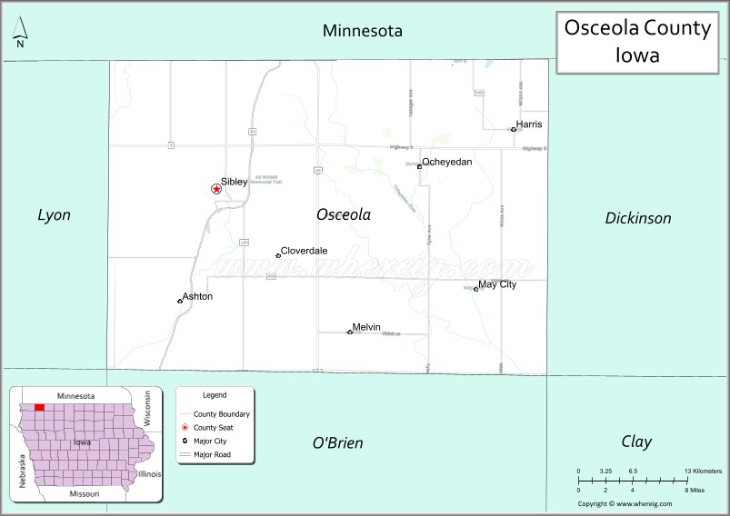
About Osceola County Map, Iowa: The map showing the county boundary, county seat, major cities, highways, water bodies and neighbouring counties.
More Iowa Maps & Info
| Iowa Map | Iowa County Map | Iowa Cities Map |
| Iowa Zip codes | Where is Iowa | Airports in Iowa |
| Iowa Area Codes | Iowa Blank Map | Iowa River Map |
| Iowa Physical Map | Iowa Road Map | Where is Des Moines |
Map of Osceola County, Iowa
Osceola County is a county located in the U.S. state of Iowa. It's county seat is Sibley. As per 2020 census, the population of Osceola County is 6159 people and population density is square miles. According to the United States Census Bureau, the county has a total area of 399 sq mi (1,033 km2). Osceola County was established on -17881.
Osceola County Facts
| Continent | North America |
| Country | United States |
| State | Iowa |
| County Seat | Sibley |
| Largest City/Town | Sibley |
| Established | January 15, 1851 |
| Total Area | 400 sq mi (1,036 sq km) |
| Land Area | 399 sq mi (1,033 sq km) |
| Water Area | 1 sq mi (3 sq km) |
| Population | 5,949 (Census 2020) |
| Population Density | 14.9 people per sq mi |
| Time Zone | Central Time Zone (CT) |
| Major Highways | U.S. Highway 59, Iowa Highway 9, Iowa Highway 60 |
| Major Rivers | Little Rock River, Otter Creek |
| Neighboring Counties | Rock County (MN), Nobles County (MN), Dickinson County, O'Brien County, Lyon County |
| Famous For | Sibley, agricultural production, northwest Iowa prairie landscapes, small-town communities |
| Top Attractions | Sibley Central Park, Prairie Heritage exhibits, Baker Township Park, Osceola County Historical Society Museum |
| Official Website | Official Website |
About Osceola County, Iowa
Osceola County is located in northwestern Iowa along the Minnesota border and was established in 1851. The county seat and largest city is Sibley. Agriculture dominates the local economy, with corn, soybeans, and livestock production being major industries. Osceola County is characterized by fertile farmland, welcoming small communities, and a strong agricultural heritage.
Cities and Towns in Osceola County, Iowa
| City/Town | Population (Census 2020) | Latitude & Longitude |
|---|---|---|
| Sibley (county seat) | 2,798 | 43.4036°N, 95.7592°W |
| Ashton | 971 | 43.3125°N, 95.7925°W |
| Ocheyedan | 436 | 43.4158°N, 95.5347°W |
| Harris | 214 | 43.4475°N, 95.4344°W |
| Allendorf | 42 | 43.4147°N, 95.6172°W |
| Melvin | 205 | 43.3242°N, 95.5961°W |
Best Golf Courses in Osceola County, Iowa
| Golf Course | Location | Latitude & Longitude |
|---|---|---|
| Sibley Golf & Country Club | Sibley | 43.3975°N, 95.7714°W |
| Ocheyedan Golf Course | Ocheyedan | 43.4189°N, 95.5458°W |
| Harris Lake Park Golf Area | Harris | 43.4462°N, 95.4418°W |
What are Major Roads and Highways in Osceola County
Major highways connect the county to nearby regions and cities.
- U.S. Highway 59 - major north-south route serving Sibley and connecting Iowa with Minnesota
- Iowa Highway 9 - east-west highway linking Osceola County with Dickinson and Lyon counties
- Iowa Highway 60 - important four-lane corridor connecting the county to Sioux Center and Worthington, Minnesota
Neighboring Counties of Osceola County
- Rock County, Minnesota (northwest)
- Nobles County, Minnesota (north)
- Dickinson County (east)
- O'Brien County (south)
- Lyon County (west)
What are Top Attractions in Osceola County, Iowa
The county offers a mix of natural and cultural attractions.
| Main Sight Name | City | Famous For |
|---|---|---|
| Osceola County Historical Society Museum | Sibley | County history and pioneer exhibits |
| Sibley Central Park | Sibley | Community events and recreation |
| Baker Township Park | Near Sibley | Camping, fishing, and outdoor recreation |
| Ocheyedan Mound Area | Ocheyedan | Historic and geological significance |
| Harris Lake Park | Harris | Fishing, boating, and nature activities |
| Ashton Community Heritage Center | Ashton | Local history and cultural exhibits |
| Little Rock River Corridor | Countywide | Wildlife viewing and scenic landscapes |
| Melvin Community Park | Melvin | Family recreation and local events |
| Allendorf Historic Area | Allendorf | Historic rural community landmarks |
| Prairie Restoration Areas | Countywide | Native prairie conservation and education |
| Osceola County Fairgrounds | Sibley | Agricultural fairs and community gatherings |
| Northwest Iowa Scenic Farmland Routes | Countywide | Rural scenery and photography opportunities |
Distance from Osceola County to Nearby Cities
The following distances are measured by road (driving).
- Sibley to Ashton (Osceola County), Iowa - 7 mi (11 km)
- Sibley to Ocheyedan (Osceola County), Iowa - 14 mi (23 km)
- Sibley to Harris (Osceola County), Iowa - 20 mi (32 km)
- Sibley to Melvin (Osceola County), Iowa - 10 mi (16 km)
- Sibley to Rock Rapids (Lyon County), Iowa - 20 mi (32 km)
- Sibley to Spencer (Clay County), Iowa - 29 mi (47 km)
- Sibley to Primghar (O'Brien County), Iowa - 20 mi (32 km)
- Sibley to Spirit Lake (Dickinson County), Iowa - 28 mi (45 km)
- Sibley to Worthington, Minnesota - 31 mi (50 km)
- Sibley to Luverne, Minnesota - 28 mi (45 km)
- Sibley to Sioux Falls, South Dakota - 57 mi (92 km)
- Sibley to Sioux City (Woodbury County), Iowa - 89 mi (143 km)
- Sibley to Storm Lake (Buena Vista County), Iowa - 69 mi (111 km)
- Sibley to Des Moines (Polk County), Iowa - 229 mi (369 km)
- Sibley to Minneapolis, Minnesota - 207 mi (333 km)
Nearest Airports
Nearest airport of Osceola is Des Moines International Airport (DSM / KDSM).
References
- QuickFacts - U.S. Census Bureau
- United States Census Bureau
- United States Geological Survey (USGS)
- National Geodetic Survey
- Official Osceola County Website
- Adair County Map
- Adams County Map
- Allamakee County Map
- Appanoose County Map
- Audubon County Map
- Benton County Map
- Black Hawk County Map
- Boone County Map
- Bremer County Map
- Buchanan County Map
- Buena Vista County Map
- Butler County Map
- Calhoun County Map
- Carroll County Map
- Cass County Map
- Cedar County Map
- Cerro Gordo County Map
- Cherokee County Map
- Chickasaw County Map
- Clarke County Map
- Clay County Map
- Clayton County Map
- Clinton County Map
- Crawford County Map
- Dallas County Map
- Davis County Map
- Decatur County Map
- Delaware County Map
- Des Moines County Map
- Dickinson County Map
- Dubuque County Map
- Emmet County Map
- Fayette County Map
- Floyd County Map
- Franklin County Map
- Fremont County Map
- Greene County Map
- Grundy County Map
- Guthrie County Map
- Hamilton County Map
- Hancock County Map
- Hardin County Map
- Harrison County Map
- Henry County Map
- Howard County Map
- Humboldt County Map
- Ida County Map
- Iowa County Map
- Jackson County Map
- Jasper County Map
- Jefferson County Map
- Johnson County Map
- Jones County Map
- Keokuk County Map
- Kossuth County Map
- Lee County Map
- Linn County Map
- Louisa County Map
- Lucas County Map
- Lyon County Map
- Madison County Map
- Mahaska County Map
- Marion County Map
- Marshall County Map
- Mills County Map
- Mitchell County Map
- Monona County Map
- Monroe County Map
- Montgomery County Map
- Muscatine County Map
- O'Brien County Map
- Osceola County Map
- Page County Map
- Palo Alto County Map
- Plymouth County Map
- Pocahontas County Map
- Polk County Map
- Pottawattamie County Map
- Poweshiek County Map
- Ringgold County Map
- Sac County Map
- Scott County Map
- Shelby County Map
- Sioux County Map
- Story County Map
- Tama County Map
- Taylor County Map
- Union County Map
- Van Buren County Map
- Wapello County Map
- Warren County Map
- Washington County Map
- Wayne County Map
- Webster County Map
- Winnebago County Map
- Winneshiek County Map
- Woodbury County Map
- Worth County Map
- Wright County Map
- Alabama Counties
- Alaska boroughs
- Arizona Counties
- Arkansas Counties
- California County Map
- Colorado Counties
- Connecticut Counties
- Delaware Counties
- Florida County Map
- Georgia County Map
- Hawaii Counties
- Idaho Counties
- Illinois Counties
- Indiana Counties
- Iowa Counties
- Kansas Counties
- Kentucky Counties
- Louisiana Counties
- Maine Counties
- Maryland Counties
- Massachusetts Counties
- Michigan County Map
- Minnesota Counties
- Mississippi Counties
- Missouri Counties
- Montana Counties
- Nebraska Counties
- Nevada Counties
- New York Counties
- New Hampshire Counties
- New Jersey Counties
- New Mexico Counties
- North Carolina Counties
- North Dakota Counties
- Ohio County Map
- Oklahoma Counties
- Oregon Counties
- Pennsylvania Counties
- Rhode Island Counties
- South Carolina Counties
- South Dakota Counties
- Map of Tennessee
- Texas County Map
- Utah Counties
- Vermont Counties
- Virginia Counties
- Washington Counties
- West Virginia Counties
- Wisconsin Counties
- Wyoming Counties