Written and Fact-checked by Whereig Editors | Last Updated On: June 10, 2026
Map of Jasper County - Jasper County is a county located in the U.S. state of Iowa. Jasper County Map showing cities, highways, important places and water bodies. Get Where is Jasper County located in the map, major cities in Jasper county, population, areas, and places of interest.
Jasper County Map, Iowa
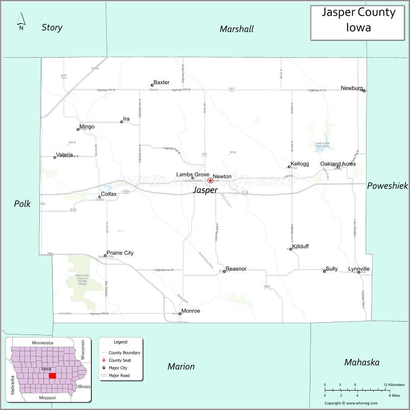
About Jasper County Map, Iowa: The map showing the county boundary, county seat, major cities, highways, water bodies and neighbouring counties.
More Iowa Maps & Info
| Iowa Map | Iowa County Map | Iowa Cities Map |
| Iowa Zip codes | Where is Iowa | Airports in Iowa |
| Iowa Area Codes | Iowa Blank Map | Iowa River Map |
| Iowa Physical Map | Iowa Road Map | Where is Des Moines |
Map of Jasper County, Iowa
Jasper County is a county located in the U.S. state of Iowa. It's county seat is Newton. As per 2020 census, the population of Jasper County is 37764 people and population density is square miles. According to the United States Census Bureau, the county has a total area of 730 sq mi (1,891 km2). Jasper County was established on -19709.
Jasper County Facts
| Continent | North America |
| Country | United States |
| State | Iowa |
| County Seat | Newton |
| Largest City/Town | Newton |
| Established | January 13, 1846 |
| Total Area | 730 sq mi (1,891 sq km) |
| Land Area | 730 sq mi (1,891 sq km) |
| Water Area | 0.5 sq mi (1 sq km) |
| Population | 37,813 (Census 2020) |
| Population Density | 51.8 people per sq mi |
| Time Zone | Central Time Zone (CT) |
| Major Highways | Interstate 80, U.S. Highway 6, Iowa Highway 14, Iowa Highway 163, Iowa Highway 117 |
| Major Rivers | Skunk River, North Skunk River |
| Neighboring Counties | Marshall County, Poweshiek County, Mahaska County, Marion County, Polk County, Story County |
| Famous For | Newton, Iowa Speedway, Maytag heritage, Neal Smith National Wildlife Refuge |
| Top Attractions | Iowa Speedway, Neal Smith National Wildlife Refuge, Maytag Dairy Farms, Jasper County Historical Museum |
| Official Website | Official Website |
About Jasper County, Iowa
Jasper County is located in central Iowa and was established in 1846. The county seat and largest city is Newton. The county is known for its manufacturing heritage, particularly its long association with the Maytag Company, as well as major recreational and conservation attractions. Jasper County combines thriving communities, rich farmland, and natural prairie restoration projects that attract visitors from across the Midwest.
Cities and Towns in Jasper County, Iowa
| City/Town | Population (Census 2020) | Latitude & Longitude |
|---|---|---|
| Newton (county seat) | 15,760 | 41.6995°N, 93.0547°W |
| Colfax | 2,093 | 41.6778°N, 93.2458°W |
| Monroe | 1,830 | 41.5227°N, 93.1027°W |
| Prairie City | 1,761 | 41.5981°N, 93.2433°W |
| Baxter | 1,101 | 41.8260°N, 93.1516°W |
| Mingo | 302 | 41.7897°N, 93.2837°W |
| Sully | 950 | 41.5785°N, 92.8458°W |
| Lambs Grove | 172 | 41.6950°N, 93.0830°W |
| Lynnville | 379 | 41.5730°N, 92.8205°W |
| Reasnor | 143 | 41.5780°N, 93.0276°W |
| Valeria | 57 | 41.7527°N, 93.3210°W |
| Kellogg | 599 | 41.7190°N, 92.9072°W |
Best Golf Courses in Jasper County, Iowa
| Golf Course | Location | Latitude & Longitude |
|---|---|---|
| Westwood Golf Course | Newton | 41.6858°N, 93.0725°W |
| Colfax Country Club | Colfax | 41.6752°N, 93.2586°W |
| Oakmoor Golf Club | Prairie City | 41.5948°N, 93.2524°W |
| Jasper County Golf Club | Baxter | 41.8297°N, 93.1599°W |
| Gateway Recreation Golf Area | Monroe | 41.5242°N, 93.1108°W |
What are Major Roads and Highways in Jasper County
Major highways connect the county to nearby regions and cities.
- Interstate 80 - major east-west interstate connecting Newton with Des Moines, Iowa City, and the Quad Cities
- U.S. Highway 6 - historic route serving Newton, Colfax, and surrounding communities
- Iowa Highway 14 - north-south corridor linking Jasper County with Marshalltown and Knoxville
- Iowa Highway 163 - expressway connecting Prairie City, Monroe, and Des Moines
- Iowa Highway 117 - regional route serving Colfax, Mingo, and northern Jasper County
Neighboring Counties of Jasper County
- Story County (north)
- Marshall County (northeast)
- Poweshiek County (east)
- Mahaska County (southeast)
- Marion County (south)
- Polk County (west)
What are Top Attractions in Jasper County, Iowa
The county offers a mix of natural and cultural attractions.
| Main Sight Name | City | Famous For |
|---|---|---|
| Iowa Speedway | Newton | Major motorsports venue hosting national racing events |
| Neal Smith National Wildlife Refuge | Prairie City | Prairie restoration, bison, elk, and wildlife viewing |
| Jasper County Historical Museum | Newton | County history exhibits and heritage collections |
| Maytag Dairy Farms | Newton | Historic dairy operation famous for blue cheese production |
| Agnes Patterson Memorial Park | Newton | Walking trails, gardens, and recreation facilities |
| Westwood Golf Course | Newton | Popular public golf destination |
| Rock Creek State Park | Kellogg Area | Camping, boating, fishing, and hiking |
| Prairie City Historical Museum | Prairie City | Local history and cultural exhibits |
| Colfax Railroad Museum | Colfax | Railroad heritage and community history |
| Monroe City Park | Monroe | Family recreation and community events |
| Jacob Krumm Nature Preserve | Newton Area | Nature trails and wildlife observation |
| Skunk River Greenbelt | Countywide | Fishing, kayaking, and scenic landscapes |
Distance from Jasper County to Nearby Cities
The following distances are measured by road (driving).
- Newton to Colfax (Jasper County), Iowa - 11 mi (18 km)
- Newton to Prairie City (Jasper County), Iowa - 14 mi (23 km)
- Newton to Marshalltown (Marshall County), Iowa - 31 mi (50 km)
- Newton to Grinnell (Poweshiek County), Iowa - 18 mi (29 km)
- Newton to Oskaloosa (Mahaska County), Iowa - 39 mi (63 km)
- Newton to Knoxville (Marion County), Iowa - 34 mi (55 km)
- Newton to Des Moines (Polk County), Iowa - 35 mi (56 km)
- Newton to Ames (Story County), Iowa - 39 mi (63 km)
- Newton to Pella (Marion County), Iowa - 21 mi (34 km)
- Newton to Altoona (Polk County), Iowa - 25 mi (40 km)
- Newton to Iowa City (Johnson County), Iowa - 73 mi (117 km)
- Newton to Cedar Rapids (Linn County), Iowa - 83 mi (134 km)
- Newton to Davenport (Scott County), Iowa - 119 mi (191 km)
- Newton to Omaha, Nebraska - 167 mi (269 km)
- Newton to Minneapolis, Minnesota - 248 mi (399 km)
Nearest Airports
Nearest airport of Jasper is Evansville (EVV) Airport.
References
- QuickFacts - U.S. Census Bureau
- United States Census Bureau
- United States Geological Survey (USGS)
- National Geodetic Survey
- Official County Website
- Adair County Map
- Adams County Map
- Allamakee County Map
- Appanoose County Map
- Audubon County Map
- Benton County Map
- Black Hawk County Map
- Boone County Map
- Bremer County Map
- Buchanan County Map
- Buena Vista County Map
- Butler County Map
- Calhoun County Map
- Carroll County Map
- Cass County Map
- Cedar County Map
- Cerro Gordo County Map
- Cherokee County Map
- Chickasaw County Map
- Clarke County Map
- Clay County Map
- Clayton County Map
- Clinton County Map
- Crawford County Map
- Dallas County Map
- Davis County Map
- Decatur County Map
- Delaware County Map
- Des Moines County Map
- Dickinson County Map
- Dubuque County Map
- Emmet County Map
- Fayette County Map
- Floyd County Map
- Franklin County Map
- Fremont County Map
- Greene County Map
- Grundy County Map
- Guthrie County Map
- Hamilton County Map
- Hancock County Map
- Hardin County Map
- Harrison County Map
- Henry County Map
- Howard County Map
- Humboldt County Map
- Ida County Map
- Iowa County Map
- Jackson County Map
- Jasper County Map
- Jefferson County Map
- Johnson County Map
- Jones County Map
- Keokuk County Map
- Kossuth County Map
- Lee County Map
- Linn County Map
- Louisa County Map
- Lucas County Map
- Lyon County Map
- Madison County Map
- Mahaska County Map
- Marion County Map
- Marshall County Map
- Mills County Map
- Mitchell County Map
- Monona County Map
- Monroe County Map
- Montgomery County Map
- Muscatine County Map
- O'Brien County Map
- Osceola County Map
- Page County Map
- Palo Alto County Map
- Plymouth County Map
- Pocahontas County Map
- Polk County Map
- Pottawattamie County Map
- Poweshiek County Map
- Ringgold County Map
- Sac County Map
- Scott County Map
- Shelby County Map
- Sioux County Map
- Story County Map
- Tama County Map
- Taylor County Map
- Union County Map
- Van Buren County Map
- Wapello County Map
- Warren County Map
- Washington County Map
- Wayne County Map
- Webster County Map
- Winnebago County Map
- Winneshiek County Map
- Woodbury County Map
- Worth County Map
- Wright County Map
- Alabama Counties
- Alaska boroughs
- Arizona Counties
- Arkansas Counties
- California County Map
- Colorado Counties
- Connecticut Counties
- Delaware Counties
- Florida County Map
- Georgia County Map
- Hawaii Counties
- Idaho Counties
- Illinois Counties
- Indiana Counties
- Iowa Counties
- Kansas Counties
- Kentucky Counties
- Louisiana Counties
- Maine Counties
- Maryland Counties
- Massachusetts Counties
- Michigan County Map
- Minnesota Counties
- Mississippi Counties
- Missouri Counties
- Montana Counties
- Nebraska Counties
- Nevada Counties
- New York Counties
- New Hampshire Counties
- New Jersey Counties
- New Mexico Counties
- North Carolina Counties
- North Dakota Counties
- Ohio County Map
- Oklahoma Counties
- Oregon Counties
- Pennsylvania Counties
- Rhode Island Counties
- South Carolina Counties
- South Dakota Counties
- Map of Tennessee
- Texas County Map
- Utah Counties
- Vermont Counties
- Virginia Counties
- Washington Counties
- West Virginia Counties
- Wisconsin Counties
- Wyoming Counties