Written and Fact-checked by Whereig Editors | Last Updated On: June 10, 2026
Map of Harrison County - Harrison County is a county located in the U.S. state of Iowa. Harrison County Map showing cities, highways, important places and water bodies. Get Where is Harrison County located in the map, major cities in Harrison county, population, areas, and places of interest.
Harrison County Map, Iowa
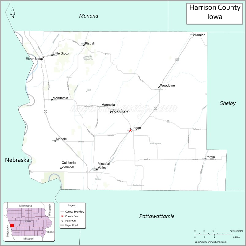
About Harrison County Map, Iowa: The map showing the county boundary, county seat, major cities, highways, water bodies and neighbouring counties.
More Iowa Maps & Info
| Iowa Map | Iowa County Map | Iowa Cities Map |
| Iowa Zip codes | Where is Iowa | Airports in Iowa |
| Iowa Area Codes | Iowa Blank Map | Iowa River Map |
| Iowa Physical Map | Iowa Road Map | Where is Des Moines |
Map of Harrison County, Iowa
Harrison County is a county located in the U.S. state of Iowa. It's county seat is Logan. As per 2020 census, the population of Harrison County is 14669 people and population density is square miles. According to the United States Census Bureau, the county has a total area of 697 sq mi (1,805 km2). Harrison County was established on -17881.
Harrison County Facts
| Continent | North America |
| Country | United States |
| State | Iowa |
| County Seat | Logan |
| Largest City/Town | Missouri Valley |
| Established | January 15, 1851 |
| Total Area | 697 sq mi (1,805 sq km) |
| Land Area | 694 sq mi (1,797 sq km) |
| Water Area | 3 sq mi (8 sq km) |
| Population | 14,582 (Census 2020) |
| Population Density | 21.0 people per sq mi |
| Time Zone | Central Time Zone (CT) |
| Major Highways | Interstate 29, U.S. Highway 30, U.S. Highway 75, Iowa Highway 37, Iowa Highway 127 |
| Major Rivers | Missouri River, Boyer River, Little Sioux River |
| Neighboring Counties | Monona County, Shelby County, Pottawattamie County, Douglas County (NE), Washington County (NE), Burt County (NE) |
| Famous For | Loess Hills, DeSoto National Wildlife Refuge, Missouri River Valley, scenic byways |
| Top Attractions | DeSoto National Wildlife Refuge, Loess Hills State Forest, Wilson Island State Recreation Area, Harrison County Historical Village |
| Official Website | Official Website |
About Harrison County, Iowa
Harrison County is located in western Iowa along the Missouri River and was established in 1851. The county seat is Logan, while Missouri Valley is the largest city. The county is known for its dramatic Loess Hills landscapes, extensive wildlife habitats, and rich agricultural heritage. Harrison County offers a unique combination of scenic natural areas, outdoor recreation, and historic communities.
Cities and Towns in Harrison County, Iowa
| City/Town | Population (Census 2020) | Latitude & Longitude |
|---|---|---|
| Logan (county seat) | 1,455 | 41.6449°N, 95.7886°W |
| Missouri Valley | 2,678 | 41.5566°N, 95.8878°W |
| Dunlap | 951 | 41.8567°N, 95.6027°W |
| Woodbine | 1,319 | 41.7369°N, 95.7025°W |
| Modale | 273 | 41.6231°N, 96.0115°W |
| Mondamin | 363 | 41.7097°N, 96.0200°W |
| Persia | 298 | 41.8395°N, 95.6338°W |
| Magnolia | 183 | 41.7011°N, 95.8775°W |
| Pisgah | 249 | 41.8268°N, 95.9311°W |
| Little Sioux | 170 | 41.8133°N, 96.0008°W |
Best Golf Courses in Harrison County, Iowa
| Golf Course | Location | Latitude & Longitude |
|---|---|---|
| Logan-Missouri Valley Country Club | Logan | 41.6507°N, 95.7994°W |
| Dunlap Golf Course | Dunlap | 41.8611°N, 95.6118°W |
| Woodbine Golf Course | Woodbine | 41.7427°N, 95.7134°W |
| Magnolia Golf Club | Magnolia | 41.7056°N, 95.8834°W |
What are Major Roads and Highways in Harrison County
Major highways connect the county to nearby regions and cities.
- Interstate 29 - major north-south interstate following the Missouri River Valley and connecting the county with Council Bluffs and Sioux City
- U.S. Highway 30 - important east-west route serving Missouri Valley and Logan
- U.S. Highway 75 - major corridor linking western Iowa communities and Nebraska destinations
- Iowa Highway 37 - serves northern Harrison County and connects local communities
- Iowa Highway 127 - scenic route through the Loess Hills region and county seat of Logan
Neighboring Counties of Harrison County
- Monona County (north)
- Shelby County (east)
- Pottawattamie County (south)
- Burt County, Nebraska (west)
- Washington County, Nebraska (southwest)
- Douglas County, Nebraska (southwest)
What are Top Attractions in Harrison County, Iowa
The county offers a mix of natural and cultural attractions.
| Main Sight Name | City | Famous For |
|---|---|---|
| DeSoto National Wildlife Refuge | Missouri Valley | Wildlife viewing, migratory birds, and visitor center exhibits |
| Loess Hills State Forest | Pisgah | Hiking, scenic overlooks, and unique landforms |
| Wilson Island State Recreation Area | Missouri Valley | Camping, boating, fishing, and Missouri River access |
| Harrison County Historical Village | Missouri Valley | Historic buildings and pioneer heritage |
| Murray Hill Scenic Overlook | Loess Hills Region | Panoramic views of the Missouri River Valley |
| Preparation Canyon State Park | Pisgah Area | Backcountry hiking and natural beauty |
| Loess Hills Scenic Byway | Countywide | One of Iowa's most scenic driving routes |
| Woodbine Main Street District | Woodbine | Historic downtown and local shops |
| Pisgah Historical Museum | Pisgah | Local history and pioneer exhibits |
| Boyer River Corridor | Countywide | Fishing, kayaking, and wildlife habitat |
| Little Sioux Recreation Area | Little Sioux | Outdoor recreation and nature viewing |
| Magnolia Heritage Center | Magnolia | Community history and cultural displays |
Distance from Harrison County to Nearby Cities
The following distances are measured by road (driving).
- Logan to Missouri Valley (Harrison County), Iowa - 8 mi (13 km)
- Logan to Dunlap (Harrison County), Iowa - 18 mi (29 km)
- Logan to Woodbine (Harrison County), Iowa - 11 mi (18 km)
- Logan to Onawa (Monona County), Iowa - 34 mi (55 km)
- Logan to Harlan (Shelby County), Iowa - 28 mi (45 km)
- Logan to Council Bluffs (Pottawattamie County), Iowa - 28 mi (45 km)
- Logan to Blair (Washington County), Nebraska - 26 mi (42 km)
- Logan to Tekamah (Burt County), Nebraska - 29 mi (47 km)
- Logan to Omaha, Nebraska - 35 mi (56 km)
- Logan to Sioux City (Woodbury County), Iowa - 74 mi (119 km)
- Logan to Atlantic (Cass County), Iowa - 55 mi (89 km)
- Logan to Carroll (Carroll County), Iowa - 52 mi (84 km)
- Logan to Des Moines (Polk County), Iowa - 89 mi (143 km)
- Logan to Lincoln, Nebraska - 89 mi (143 km)
- Logan to Cedar Rapids (Linn County), Iowa - 191 mi (307 km)
Nearest Airports
Nearest airport of Harrison is Waterloo Regional Airport (ALO / KALO).
References
- QuickFacts - U.S. Census Bureau
- United States Census Bureau
- United States Geological Survey (USGS)
- National Geodetic Survey
- Official County Website
- Adair County Map
- Adams County Map
- Allamakee County Map
- Appanoose County Map
- Audubon County Map
- Benton County Map
- Black Hawk County Map
- Boone County Map
- Bremer County Map
- Buchanan County Map
- Buena Vista County Map
- Butler County Map
- Calhoun County Map
- Carroll County Map
- Cass County Map
- Cedar County Map
- Cerro Gordo County Map
- Cherokee County Map
- Chickasaw County Map
- Clarke County Map
- Clay County Map
- Clayton County Map
- Clinton County Map
- Crawford County Map
- Dallas County Map
- Davis County Map
- Decatur County Map
- Delaware County Map
- Des Moines County Map
- Dickinson County Map
- Dubuque County Map
- Emmet County Map
- Fayette County Map
- Floyd County Map
- Franklin County Map
- Fremont County Map
- Greene County Map
- Grundy County Map
- Guthrie County Map
- Hamilton County Map
- Hancock County Map
- Hardin County Map
- Harrison County Map
- Henry County Map
- Howard County Map
- Humboldt County Map
- Ida County Map
- Iowa County Map
- Jackson County Map
- Jasper County Map
- Jefferson County Map
- Johnson County Map
- Jones County Map
- Keokuk County Map
- Kossuth County Map
- Lee County Map
- Linn County Map
- Louisa County Map
- Lucas County Map
- Lyon County Map
- Madison County Map
- Mahaska County Map
- Marion County Map
- Marshall County Map
- Mills County Map
- Mitchell County Map
- Monona County Map
- Monroe County Map
- Montgomery County Map
- Muscatine County Map
- O'Brien County Map
- Osceola County Map
- Page County Map
- Palo Alto County Map
- Plymouth County Map
- Pocahontas County Map
- Polk County Map
- Pottawattamie County Map
- Poweshiek County Map
- Ringgold County Map
- Sac County Map
- Scott County Map
- Shelby County Map
- Sioux County Map
- Story County Map
- Tama County Map
- Taylor County Map
- Union County Map
- Van Buren County Map
- Wapello County Map
- Warren County Map
- Washington County Map
- Wayne County Map
- Webster County Map
- Winnebago County Map
- Winneshiek County Map
- Woodbury County Map
- Worth County Map
- Wright County Map
- Alabama Counties
- Alaska boroughs
- Arizona Counties
- Arkansas Counties
- California County Map
- Colorado Counties
- Connecticut Counties
- Delaware Counties
- Florida County Map
- Georgia County Map
- Hawaii Counties
- Idaho Counties
- Illinois Counties
- Indiana Counties
- Iowa Counties
- Kansas Counties
- Kentucky Counties
- Louisiana Counties
- Maine Counties
- Maryland Counties
- Massachusetts Counties
- Michigan County Map
- Minnesota Counties
- Mississippi Counties
- Missouri Counties
- Montana Counties
- Nebraska Counties
- Nevada Counties
- New York Counties
- New Hampshire Counties
- New Jersey Counties
- New Mexico Counties
- North Carolina Counties
- North Dakota Counties
- Ohio County Map
- Oklahoma Counties
- Oregon Counties
- Pennsylvania Counties
- Rhode Island Counties
- South Carolina Counties
- South Dakota Counties
- Map of Tennessee
- Texas County Map
- Utah Counties
- Vermont Counties
- Virginia Counties
- Washington Counties
- West Virginia Counties
- Wisconsin Counties
- Wyoming Counties