Written and Fact-checked by Whereig Editors | Last Updated On: June 10, 2026
Map of Crawford County - Crawford County is a county located in the U.S. state of Iowa. Crawford County Map showing cities, highways, important places and water bodies. Get Where is Crawford County located in the map, major cities in Crawford county, population, areas, and places of interest.
Crawford County Map, Iowa
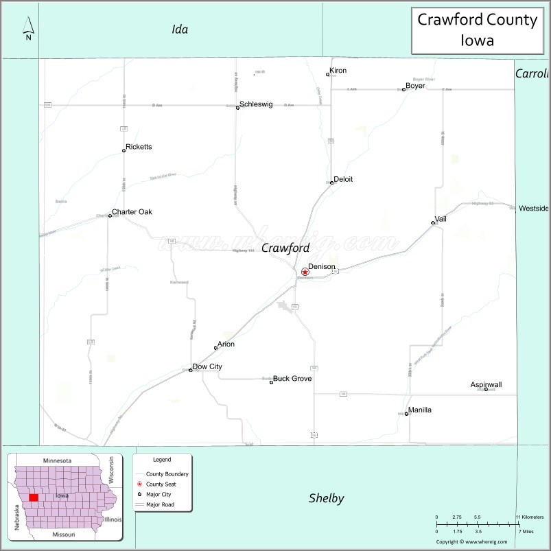
About Crawford County Map, Iowa: The map showing the county boundary, county seat, major cities, highways, water bodies and neighbouring counties.
More Iowa Maps & Info
| Iowa Map | Iowa County Map | Iowa Cities Map |
| Iowa Zip codes | Where is Iowa | Airports in Iowa |
| Iowa Area Codes | Iowa Blank Map | Iowa River Map |
| Iowa Physical Map | Iowa Road Map | Where is Des Moines |
Map of Crawford County, Iowa
Crawford County is a county located in the U.S. state of Iowa. It's county seat is Denison. As per 2020 census, the population of Crawford County is 16193 people and population density is square miles. According to the United States Census Bureau, the county has a total area of 714 sq mi (1,849 km2). Crawford County was established on -17881.
Crawford County Facts
| Continent | North America |
| Country | United States |
| State | Iowa |
| County Seat | Denison |
| Largest City/Town | Denison |
| Established | January 15, 1851 |
| Total Area | 715 sq mi (1,852 sq km) |
| Land Area | 714 sq mi (1,849 sq km) |
| Water Area | 1 sq mi (3 sq km) |
| Population | 16,525 (Census 2020) |
| Population Density | 23.1 people per sq mi |
| Time Zone | Central Time Zone (CT) |
| Major Highways | U.S. Highway 30, U.S. Highway 59, Iowa Highway 39, Iowa Highway 141 |
| Major Rivers | Boyer River, Soldier River |
| Neighboring Counties | Sac County, Carroll County, Shelby County, Monona County, Harrison County, Ida County |
| Famous For | Denison, Donna Reed heritage, agriculture, Boyer River Valley, diverse cultural community |
| Top Attractions | Donna Reed Birthplace Museum, Yellow Smoke Park, Crawford County Nature Center, Dow House Historic Site |
| Official Website | Official Website |
About Crawford County, Iowa
Crawford County is located in west-central Iowa and was established in 1851. The county seat is Denison, which is also the largest city. The county is known for its rolling hills, productive farmland, and the scenic Boyer River Valley. Crawford County has a strong agricultural economy and is recognized for its cultural diversity and historic ties to actress Donna Reed.
Cities and Towns in Crawford County, Iowa
| City Name | Type | Population (2020) | Pop. Density | Area | Incorporated |
|---|---|---|---|---|---|
| Flat Rock | Village | 323 | 377.3/sq mi (145.7/km2) | 0.856 sq mi (2.22 km2) | |
| Hutsonville | Village | 478 | 768.5/sq mi (296.7/km2) | 0.622 sq mi (1.61 km2) | |
| Oblong | Village | 1,371 | 1,262.4/sq mi (487.4/km2) | 1.086 sq mi (2.81 km2) | |
| Palestine | Village | 1,233 | 1,562.7/sq mi (603.4/km2) | 0.789 sq mi (2.04 km2) | |
| Robinson | City | 7,150 | 1,521.6/sq mi (587.5/km2) | 4.699 sq mi (12.17 km2) | |
| Stoy | Village | 108 | 115.9/sq mi (44.7/km2) | 0.932 sq mi (2.41 km2) | |
| Arion | 97 | 0.47 sq mi (1.2 km2) | May 31, 1894 | ||
| Aspinwall | 33 | 0.18 sq mi (0.47 km2) | November 10, 1914 | ||
| Buck Grove | 34 | 0.36 sq mi (0.93 km2) | June 29, 1906 | ||
| Charter Oak | 0.48 sq mi (1.2 km2) | February 6, 1891 | |||
| Deloit | 0.42 sq mi (1.1 km2) | May 19, 1900 | |||
| Denison | 6.54 sq mi (16.9 km2) | October 2, 1875 | |||
| Dow City | 0.32 sq mi (0.83 km2) | February 22, 1884 | |||
| Kiron | 0.21 sq mi (0.54 km2) | June 22, 1900 | |||
| Manilla | 1.03 sq mi (2.7 km2) | October 3, 1887 | |||
| Ricketts | 0.26 sq mi (0.67 km2) | March 19, 1902 | |||
| Schleswig | 1.3 sq mi (3.4 km2) | February 15, 1900 | |||
| Vail | 0.57 sq mi (1.5 km2) | October 1, 1875 | |||
| Westside | 1.47 sq mi (3.8 km2) | 1871 | |||
| Dunlap | 1.13 sq mi (2.9 km2) | January 1871 |
Best Golf Courses in Crawford County, Iowa
| Golf Course | Location | Latitude & Longitude |
|---|---|---|
| Denison Golf Club | Denison | 42.0318°N, 95.3512°W |
| Yellow Smoke Golf Course | Denison | 42.0156°N, 95.3845°W |
| Dunlap Golf Club | Dow City Area | 41.8565°N, 95.6078°W |
| Arcadia Golf Course | Arcadia | 42.0853°N, 95.0468°W |
What are Major Roads and Highways in Crawford County
Major highways connect the county to nearby regions and cities.
- U.S. Highway 30 - major east-west route connecting Denison with Carroll, Boone, and the Omaha region
- U.S. Highway 59 - north-south corridor linking Denison with Cherokee, Shenandoah, and western Iowa communities
- Iowa Highway 39 - connects Denison with communities in Shelby and Crawford counties
- Iowa Highway 141 - serves southern Crawford County and provides access to regional destinations
Neighboring Counties of Crawford County
- Sac County (north)
- Carroll County (east)
- Shelby County (southeast)
- Harrison County (south)
- Monona County (west)
- Ida County (northwest)
What are Top Attractions in Crawford County, Iowa
The county offers a mix of natural and cultural attractions.
| Main Sight Name | City | Famous For |
|---|---|---|
| Donna Reed Birthplace Museum | Denison | Museum dedicated to Academy Award-winning actress Donna Reed |
| Yellow Smoke Park | Denison | Camping, fishing, hiking trails, and outdoor recreation |
| Crawford County Nature Center | Denison | Environmental education and nature exhibits |
| Dow House Historic Site | Dow City | Historic home and local heritage attraction |
| Boyer River Valley Scenic Area | Countywide | Rolling hills, wildlife viewing, and scenic drives |
| Denison City Park | Denison | Family recreation and community events |
| Crawford County Historical Museum | Denison | Regional history and pioneer exhibits |
| Schleswig Community Park | Schleswig | Outdoor recreation and local events |
| Westside Historical Area | Westside | Small-town history and community heritage |
| Charter Oak Historic District | Charter Oak | Historic architecture and local culture |
| Soldier River Corridor | Countywide | Wildlife habitat and outdoor recreation |
| Denison Aquatic Fun Center | Denison | Family-friendly water recreation |
Distance from Crawford County to Nearby Cities
The following distances are measured by road (driving).
- Denison to Carroll (Carroll County), Iowa - 31 mi (50 km)
- Denison to Ida Grove (Ida County), Iowa - 25 mi (40 km)
- Denison to Harlan (Shelby County), Iowa - 32 mi (52 km)
- Denison to Logan (Harrison County), Iowa - 35 mi (56 km)
- Denison to Onawa (Monona County), Iowa - 39 mi (63 km)
- Denison to Storm Lake (Buena Vista County), Iowa - 38 mi (61 km)
- Denison to Cherokee (Cherokee County), Iowa - 55 mi (89 km)
- Denison to Council Bluffs (Pottawattamie County), Iowa - 58 mi (93 km)
- Denison to Sioux City (Woodbury County), Iowa - 65 mi (105 km)
- Denison to Fort Dodge (Webster County), Iowa - 88 mi (142 km)
- Denison to Omaha, Nebraska - 67 mi (108 km)
- Denison to Ames (Story County), Iowa - 104 mi (167 km)
- Denison to Des Moines (Polk County), Iowa - 118 mi (190 km)
- Denison to Sioux Falls, South Dakota - 138 mi (222 km)
- Denison to Kansas City, Missouri - 194 mi (312 km)
Nearest Airports
Nearest airport of Crawford is Sioux Gateway Airport (SUX / KSUX).
References
- QuickFacts - U.S. Census Bureau
- United States Census Bureau
- United States Geological Survey (USGS)
- National Geodetic Survey
- Official County Website
- Adair County Map
- Adams County Map
- Allamakee County Map
- Appanoose County Map
- Audubon County Map
- Benton County Map
- Black Hawk County Map
- Boone County Map
- Bremer County Map
- Buchanan County Map
- Buena Vista County Map
- Butler County Map
- Calhoun County Map
- Carroll County Map
- Cass County Map
- Cedar County Map
- Cerro Gordo County Map
- Cherokee County Map
- Chickasaw County Map
- Clarke County Map
- Clay County Map
- Clayton County Map
- Clinton County Map
- Crawford County Map
- Dallas County Map
- Davis County Map
- Decatur County Map
- Delaware County Map
- Des Moines County Map
- Dickinson County Map
- Dubuque County Map
- Emmet County Map
- Fayette County Map
- Floyd County Map
- Franklin County Map
- Fremont County Map
- Greene County Map
- Grundy County Map
- Guthrie County Map
- Hamilton County Map
- Hancock County Map
- Hardin County Map
- Harrison County Map
- Henry County Map
- Howard County Map
- Humboldt County Map
- Ida County Map
- Iowa County Map
- Jackson County Map
- Jasper County Map
- Jefferson County Map
- Johnson County Map
- Jones County Map
- Keokuk County Map
- Kossuth County Map
- Lee County Map
- Linn County Map
- Louisa County Map
- Lucas County Map
- Lyon County Map
- Madison County Map
- Mahaska County Map
- Marion County Map
- Marshall County Map
- Mills County Map
- Mitchell County Map
- Monona County Map
- Monroe County Map
- Montgomery County Map
- Muscatine County Map
- O'Brien County Map
- Osceola County Map
- Page County Map
- Palo Alto County Map
- Plymouth County Map
- Pocahontas County Map
- Polk County Map
- Pottawattamie County Map
- Poweshiek County Map
- Ringgold County Map
- Sac County Map
- Scott County Map
- Shelby County Map
- Sioux County Map
- Story County Map
- Tama County Map
- Taylor County Map
- Union County Map
- Van Buren County Map
- Wapello County Map
- Warren County Map
- Washington County Map
- Wayne County Map
- Webster County Map
- Winnebago County Map
- Winneshiek County Map
- Woodbury County Map
- Worth County Map
- Wright County Map
- Alabama Counties
- Alaska boroughs
- Arizona Counties
- Arkansas Counties
- California County Map
- Colorado Counties
- Connecticut Counties
- Delaware Counties
- Florida County Map
- Georgia County Map
- Hawaii Counties
- Idaho Counties
- Illinois Counties
- Indiana Counties
- Iowa Counties
- Kansas Counties
- Kentucky Counties
- Louisiana Counties
- Maine Counties
- Maryland Counties
- Massachusetts Counties
- Michigan County Map
- Minnesota Counties
- Mississippi Counties
- Missouri Counties
- Montana Counties
- Nebraska Counties
- Nevada Counties
- New York Counties
- New Hampshire Counties
- New Jersey Counties
- New Mexico Counties
- North Carolina Counties
- North Dakota Counties
- Ohio County Map
- Oklahoma Counties
- Oregon Counties
- Pennsylvania Counties
- Rhode Island Counties
- South Carolina Counties
- South Dakota Counties
- Map of Tennessee
- Texas County Map
- Utah Counties
- Vermont Counties
- Virginia Counties
- Washington Counties
- West Virginia Counties
- Wisconsin Counties
- Wyoming Counties