Written and Fact-checked by Whereig Editors | Last Updated On: June 10, 2026
Map of Tama County - Tama County is a county located in the U.S. state of Iowa. Tama County Map showing cities, highways, important places and water bodies. Get Where is Tama County located in the map, major cities in Tama county, population, areas, and places of interest.
Tama County Map, Iowa
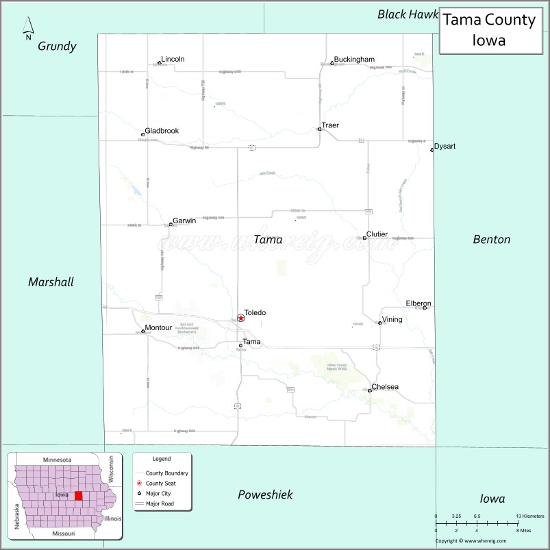
About Tama County Map, Iowa: The map showing the county boundary, county seat, major cities, highways, water bodies and neighbouring counties.
More Iowa Maps & Info
| Iowa Map | Iowa County Map | Iowa Cities Map |
| Iowa Zip codes | Where is Iowa | Airports in Iowa |
| Iowa Area Codes | Iowa Blank Map | Iowa River Map |
| Iowa Physical Map | Iowa Road Map | Where is Des Moines |
Map of Tama County, Iowa
Tama County is a county located in the U.S. state of Iowa. It's county seat is Toledo. As per 2020 census, the population of Tama County is 16867 people and population density is square miles. According to the United States Census Bureau, the county has a total area of 721 sq mi (1,867 km2). Tama County was established on -20770.
Tama County Facts
| Continent | North America |
| Country | United States |
| State | Iowa |
| County Seat | Toledo |
| Largest City/Town | Tama |
| Established | February 17, 1843 |
| Total Area | 722 sq mi (1,870 sq km) |
| Land Area | 721 sq mi (1,868 sq km) |
| Water Area | 1 sq mi (2 sq km) |
| Population | 17,135 (Census 2020) |
| Population Density | 23.8 people per sq mi |
| Time Zone | Central Time Zone (CT) |
| Major Highways | U.S. Highway 30, U.S. Highway 63, Iowa Highway 21, Iowa Highway 96 |
| Major Rivers | Iowa River, Salt Creek, Wolf Creek |
| Neighboring Counties | Grundy County, Benton County, Iowa County, Poweshiek County, Marshall County, Black Hawk County |
| Famous For | Meskwaki Settlement, Meskwaki Nation, Tama-Toledo communities, agriculture, cultural heritage |
| Top Attractions | Meskwaki Cultural Center and Museum, Meskwaki Powwow, Otter Creek Lake and Park, Wieting Theatre |
| Official Website | Official Website |
About Tama County, Iowa
Tama County is located in central-eastern Iowa and was established in 1843. The county seat is Toledo, while Tama is the largest city. The county is best known as the home of the Meskwaki Nation, the only federally recognized Indian settlement in Iowa. Agriculture, manufacturing, education, and cultural tourism contribute significantly to the local economy. Tama County offers a unique blend of Native American heritage, small-town charm, and outdoor recreation.
Cities and Towns in Tama County, Iowa
| City/Town | Population (Census 2020) | Latitude & Longitude |
|---|---|---|
| Tama | 2,877 | 41.9667°N, 92.5763°W |
| Toledo (county seat) | 2,369 | 41.9933°N, 92.5810°W |
| Traer | 1,547 | 42.1931°N, 92.4655°W |
| Dysart | 1,281 | 42.1714°N, 92.3074°W |
| Gladbrook | 946 | 42.1878°N, 92.7164°W |
| Chelsea | 267 | 41.9475°N, 92.3952°W |
| Montour | 255 | 42.0644°N, 92.7158°W |
| Clutier | 213 | 41.9386°N, 92.4039°W |
| Garwin | 485 | 42.0925°N, 92.6775°W |
| Elberon | 196 | 42.0031°N, 92.3181°W |
| Buckingham | 27 | 42.2467°N, 92.4225°W |
| Vining | 43 | 42.1678°N, 92.3817°W |
| Meskwaki Settlement | 1,277 | 41.9964°N, 92.6314°W |
Best Golf Courses in Tama County, Iowa
| Golf Course | Location | Latitude & Longitude |
|---|---|---|
| Tama Toledo Country Club | Tama | 41.9583°N, 92.5928°W |
| Traer Golf & Country Club | Traer | 42.2014°N, 92.4758°W |
| Dysart Golf Club | Dysart | 42.1806°N, 92.3153°W |
| Otter Creek Golf Area | Toledo Area | 41.9806°N, 92.6475°W |
What are Major Roads and Highways in Tama County
Major highways provide convenient transportation access throughout central and eastern Iowa.
- U.S. Highway 30 - major east-west corridor crossing the county through Tama and Toledo
- U.S. Highway 63 - north-south route connecting Tama County with Waterloo and Oskaloosa
- Iowa Highway 21 - serves communities including Dysart and Belle Plaine connections
- Iowa Highway 96 - regional route serving northern Tama County communities
Neighboring Counties of Tama County
- Grundy County (north)
- Black Hawk County (northeast)
- Benton County (east)
- Iowa County (south)
- Poweshiek County (southwest)
- Marshall County (west)
What are Top Attractions in Tama County, Iowa
Tama County offers a combination of Native American heritage, outdoor recreation, and local history.
| Main Sight Name | City | Famous For |
|---|---|---|
| Meskwaki Cultural Center and Museum | Meskwaki Settlement | Native American history, culture, and exhibits |
| Meskwaki Annual Powwow | Meskwaki Settlement | Traditional dancing, music, and cultural celebrations |
| Otter Creek Lake and Park | Toledo Area | Camping, fishing, hiking, and boating |
| Wieting Theatre | Toledo | Historic opera house and performing arts venue |
| Tama County Historical Society Museum | Toledo | County history and pioneer exhibits |
| Traer Historical Museum | Traer | Local heritage and railroad history |
| Dysart Historical Center | Dysart | Community history and exhibits |
| Union Grove State Park | Near Gladbrook | Camping, fishing, and outdoor recreation |
| Meskwaki Bingo Casino Hotel | Meskwaki Settlement | Gaming, entertainment, and events |
| Salt Creek Recreation Areas | Countywide | Wildlife viewing and outdoor activities |
| Tama County Fairgrounds | Gladbrook | Agricultural fairs and annual events |
| Iowa River Corridor | Countywide | Scenic landscapes and nature recreation |
Distance from Tama County to Nearby Cities
The following distances are measured by road (driving) from Toledo.
- Toledo to Tama (Tama County), Iowa - 2 mi (3 km)
- Toledo to Traer (Tama County), Iowa - 15 mi (24 km)
- Toledo to Dysart (Tama County), Iowa - 16 mi (26 km)
- Toledo to Gladbrook (Tama County), Iowa - 15 mi (24 km)
- Toledo to Marshalltown (Marshall County), Iowa - 18 mi (29 km)
- Toledo to Grundy Center (Grundy County), Iowa - 29 mi (47 km)
- Toledo to Waterloo (Black Hawk County), Iowa - 43 mi (69 km)
- Toledo to Vinton (Benton County), Iowa - 31 mi (50 km)
- Toledo to Marengo (Iowa County), Iowa - 34 mi (55 km)
- Toledo to Grinnell (Poweshiek County), Iowa - 29 mi (47 km)
- Toledo to Ames (Story County), Iowa - 51 mi (82 km)
- Toledo to Cedar Rapids (Linn County), Iowa - 52 mi (84 km)
- Toledo to Iowa City (Johnson County), Iowa - 63 mi (101 km)
- Toledo to Des Moines (Polk County), Iowa - 75 mi (121 km)
- Toledo to Davenport (Scott County), Iowa - 110 mi (177 km)
Nearest Airports
Nearest airport of Tama is Eastern Iowa Airport (CID / KCID).
References
- U.S. Census Bureau - Tama County QuickFacts
- Tama County Official Website
- Meskwaki Nation Official Website
- United States Geological Survey (USGS)
- National Geodetic Survey (NGS)
- Adair County Map
- Adams County Map
- Allamakee County Map
- Appanoose County Map
- Audubon County Map
- Benton County Map
- Black Hawk County Map
- Boone County Map
- Bremer County Map
- Buchanan County Map
- Buena Vista County Map
- Butler County Map
- Calhoun County Map
- Carroll County Map
- Cass County Map
- Cedar County Map
- Cerro Gordo County Map
- Cherokee County Map
- Chickasaw County Map
- Clarke County Map
- Clay County Map
- Clayton County Map
- Clinton County Map
- Crawford County Map
- Dallas County Map
- Davis County Map
- Decatur County Map
- Delaware County Map
- Des Moines County Map
- Dickinson County Map
- Dubuque County Map
- Emmet County Map
- Fayette County Map
- Floyd County Map
- Franklin County Map
- Fremont County Map
- Greene County Map
- Grundy County Map
- Guthrie County Map
- Hamilton County Map
- Hancock County Map
- Hardin County Map
- Harrison County Map
- Henry County Map
- Howard County Map
- Humboldt County Map
- Ida County Map
- Iowa County Map
- Jackson County Map
- Jasper County Map
- Jefferson County Map
- Johnson County Map
- Jones County Map
- Keokuk County Map
- Kossuth County Map
- Lee County Map
- Linn County Map
- Louisa County Map
- Lucas County Map
- Lyon County Map
- Madison County Map
- Mahaska County Map
- Marion County Map
- Marshall County Map
- Mills County Map
- Mitchell County Map
- Monona County Map
- Monroe County Map
- Montgomery County Map
- Muscatine County Map
- O'Brien County Map
- Osceola County Map
- Page County Map
- Palo Alto County Map
- Plymouth County Map
- Pocahontas County Map
- Polk County Map
- Pottawattamie County Map
- Poweshiek County Map
- Ringgold County Map
- Sac County Map
- Scott County Map
- Shelby County Map
- Sioux County Map
- Story County Map
- Tama County Map
- Taylor County Map
- Union County Map
- Van Buren County Map
- Wapello County Map
- Warren County Map
- Washington County Map
- Wayne County Map
- Webster County Map
- Winnebago County Map
- Winneshiek County Map
- Woodbury County Map
- Worth County Map
- Wright County Map
- Alabama Counties
- Alaska boroughs
- Arizona Counties
- Arkansas Counties
- California County Map
- Colorado Counties
- Connecticut Counties
- Delaware Counties
- Florida County Map
- Georgia County Map
- Hawaii Counties
- Idaho Counties
- Illinois Counties
- Indiana Counties
- Iowa Counties
- Kansas Counties
- Kentucky Counties
- Louisiana Counties
- Maine Counties
- Maryland Counties
- Massachusetts Counties
- Michigan County Map
- Minnesota Counties
- Mississippi Counties
- Missouri Counties
- Montana Counties
- Nebraska Counties
- Nevada Counties
- New York Counties
- New Hampshire Counties
- New Jersey Counties
- New Mexico Counties
- North Carolina Counties
- North Dakota Counties
- Ohio County Map
- Oklahoma Counties
- Oregon Counties
- Pennsylvania Counties
- Rhode Island Counties
- South Carolina Counties
- South Dakota Counties
- Map of Tennessee
- Texas County Map
- Utah Counties
- Vermont Counties
- Virginia Counties
- Washington Counties
- West Virginia Counties
- Wisconsin Counties
- Wyoming Counties