Written and Fact-checked by Whereig Editors | Last Updated On: June 10, 2026
Map of Clinton County - Clinton County is a county located in the U.S. state of Iowa. Clinton County Map showing cities, highways, important places and water bodies. Get Where is Clinton County located in the map, major cities in Clinton county, population, areas, and places of interest.
Clinton County Map, Iowa
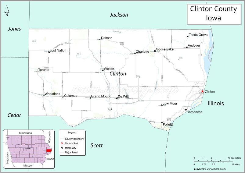
About Clinton County Map, Iowa: The map showing the county boundary, county seat, major cities, highways, water bodies and neighbouring counties.
More Iowa Maps & Info
| Iowa Map | Iowa County Map | Iowa Cities Map |
| Iowa Zip codes | Where is Iowa | Airports in Iowa |
| Iowa Area Codes | Iowa Blank Map | Iowa River Map |
| Iowa Physical Map | Iowa Road Map | Where is Des Moines |
Map of Clinton County, Iowa
Clinton County is a county located in the U.S. state of Iowa. It's county seat is Clinton. As per 2020 census, the population of Clinton County is 46463 people and population density is square miles. According to the United States Census Bureau, the county has a total area of 695 sq mi (1,800 km2). Clinton County was established on -22654.
Clinton County Facts
| Continent | North America |
| Country | United States |
| State | Iowa |
| County Seat | Clinton |
| Largest City/Town | Clinton |
| Established | December 21, 1837 |
| Total Area | 718 sq mi (1,860 sq km) |
| Land Area | 695 sq mi (1,800 sq km) |
| Water Area | 23 sq mi (60 sq km) |
| Population | 46,460 (Census 2020) |
| Population Density | 66.8 people per sq mi |
| Time Zone | Central Time Zone (CT) |
| Major Highways | Interstate 80, U.S. Highway 30, U.S. Highway 61, U.S. Highway 67, Iowa Highway 136 |
| Major Rivers | Mississippi River, Wapsipinicon River |
| Neighboring Counties | Jackson County, Jones County, Cedar County, Scott County, Whiteside County (IL), Carroll County (IL) |
| Famous For | Mississippi River frontage, lumber industry history, Eagle Point Park, riverfront communities |
| Top Attractions | Eagle Point Park, Sawmill Museum, Bickelhaupt Arboretum, Wide River Winery |
| Official Website | Official Website |
About Clinton County, Iowa
Clinton County is located in eastern Iowa along the Mississippi River and was established in 1837. The county seat is Clinton, which is also the largest city. The county developed as a major lumber and manufacturing center during the nineteenth century and remains an important transportation and industrial hub. Its riverfront location provides scenic views, recreational opportunities, and strong economic ties with neighboring Illinois communities.
Cities and Towns in Clinton County, Iowa
| City Name | Type | Population (2020) | Pop. Density | Area | Incorporated |
|---|---|---|---|---|---|
| Albers | Village | 1,121 | 1,325.1/sq mi (511.6/km2) | 0.846 sq mi (2.19 km2) | |
| Aviston | Village | 2,340 | 1,462.5/sq mi (564.7/km2) | 1.6 sq mi (4.14 km2) | |
| Bartelso | Village | 635 | 1,473.3/sq mi (568.9/km2) | 0.431 sq mi (1.12 km2) | |
| Beckemeyer | Village | 923 | 1,505.7/sq mi (581.4/km2) | 0.613 sq mi (1.59 km2) | |
| Breese | City | 4,641 | 1,738.9/sq mi (671.4/km2) | 2.669 sq mi (6.91 km2) | |
| Carlyle | City | 3,253 | 949.8/sq mi (366.7/km2) | 3.425 sq mi (8.87 km2) | |
| Damiansville | Village | 564 | 686.1/sq mi (264.9/km2) | 0.822 sq mi (2.13 km2) | |
| Germantown | Village | 1,324 | 1,305.7/sq mi (504.1/km2) | 1.014 sq mi (2.63 km2) | |
| Hoffman | Village | 439 | 867.6/sq mi (335.0/km2) | 0.506 sq mi (1.31 km2) | |
| Huey | Village | 160 | 740.7/sq mi (286.0/km2) | 0.216 sq mi (0.56 km2) | |
| St. Rose[b] | Village | 459 | 776.6/sq mi (299.9/km2) | 0.591 sq mi (1.53 km2) | |
| Trenton | City | 2,690 | 1,430.9/sq mi (552.5/km2) | 1.88 sq mi (4.87 km2) | |
| Andover | 109 | 0.19 sq mi (0.49 km2) | January 12, 1910 | ||
| Calamus | 356 | 0.48 sq mi (1.2 km2) | October 6, 1875 | ||
| Camanche | 8.68 sq mi (22.5 km2) | January 28, 1857 | |||
| Charlotte | 0.58 sq mi (1.5 km2) | December 5, 1904 | |||
| Clinton | 35.15 sq mi (91 km2) | January 26, 1857 | |||
| DeWitt | 5.98 sq mi (15.5 km2) | September 20, 1858 | |||
| Delmar | 0.76 sq mi (2 km2) | June 10, 1876 | |||
| Goose Lake | 0.32 sq mi (0.83 km2) | December 26, 1908 | |||
| Grand Mound | 1.82 sq mi (4.7 km2) | February 11, 1884 | |||
| Lost Nation | 0.64 sq mi (1.7 km2) | June 9, 1903 | |||
| Low Moor | 0.46 sq mi (1.2 km2) | February 10, 1897 | |||
| Toronto | 0.19 sq mi (0.49 km2) | July 26, 1909 | |||
| Welton | 0.27 sq mi (0.7 km2) | April 25, 1908 | |||
| Wheatland | 0.6 sq mi (1.6 km2) | July 13, 1869 | |||
| Keyesport | Village | 406 | 563.9/sq mi (217.7/km2) | 0.72 sq mi (1.86 km2) | |
| Wamac | City | 985 | 701.1/sq mi (270.7/km2) | 1.405 sq mi (3.64 km2) | |
| New Baden | Village | 3,428 | 1,878.4/sq mi (725.2/km2) | 1.825 sq mi (4.73 km2) | |
| Maquoketa | 4.33 sq mi (11.2 km2) | January 27, 1857 | |||
| Centralia | City | 12,182 | 1,485.6/sq mi (573.6/km2) | 8.2 sq mi (21.24 km2) |
Best Golf Courses in Clinton County, Iowa
| Golf Course | Location | Latitude & Longitude |
|---|---|---|
| Clinton Country Club | Clinton | 41.8671°N, 90.2425°W |
| Camanche Deanna Lynn Country Club | Camanche | 41.7826°N, 90.2665°W |
| Springbrook Country Club | DeWitt | 41.8114°N, 90.5582°W |
| Prairie Creek Golf | Low Moor | 41.8015°N, 90.3607°W |
| Lincoln Valley Golf Course | Camanche | 41.7907°N, 90.2298°W |
What are Major Roads and Highways in Clinton County
Major highways connect the county to nearby regions and cities.
- Interstate 80 - crosses southern Clinton County and connects the area with Davenport, Iowa City, and Chicago
- U.S. Highway 30 - major east-west route linking DeWitt, Clinton, and eastern Iowa communities
- U.S. Highway 61 - north-south corridor connecting Clinton with Dubuque and the Quad Cities
- U.S. Highway 67 - follows the Mississippi River corridor through riverfront communities
- Iowa Highway 136 - provides access to northeastern portions of the county and neighboring counties
Neighboring Counties of Clinton County
- Jackson County (north)
- Jones County (northwest)
- Cedar County (west)
- Scott County (south)
- Whiteside County, Illinois (east)
- Carroll County, Illinois (northeast)
What are Top Attractions in Clinton County, Iowa
The county offers a mix of natural and cultural attractions.
| Main Sight Name | City | Famous For |
|---|---|---|
| Eagle Point Park | Clinton | Mississippi River overlooks and scenic limestone structures |
| Sawmill Museum | Clinton | History of the lumber industry and river commerce |
| Bickelhaupt Arboretum | Clinton | Botanical collections and walking trails |
| Wide River Winery | Clinton | Local wines and river bluff views |
| Clinton Riverfront | Clinton | Mississippi River recreation and public events |
| George M. Curtis Mansion | Clinton | Historic Victorian architecture |
| DeWitt Historical Museum | DeWitt | Local history and pioneer exhibits |
| Rock Creek Marina | Camanche | Boating and fishing on the Mississippi River |
| Wapsipinicon State Park Access Area | DeWitt Area | Outdoor recreation and nature viewing |
| Lincoln Park | Clinton | Community recreation and green space |
| Grand Mound Heritage Museum | Grand Mound | Regional history exhibits |
| Mississippi River Scenic Corridor | Countywide | River views, wildlife habitat, and recreation |
Distance from Clinton County to Nearby Cities
The following distances are measured by road (driving).
- Clinton to DeWitt (Clinton County), Iowa - 23 mi (37 km)
- Clinton to Davenport (Scott County), Iowa - 40 mi (64 km)
- Clinton to Maquoketa (Jackson County), Iowa - 25 mi (40 km)
- Clinton to Tipton (Cedar County), Iowa - 39 mi (63 km)
- Clinton to Iowa City (Johnson County), Iowa - 71 mi (114 km)
- Clinton to Dubuque (Dubuque County), Iowa - 71 mi (114 km)
- Clinton to Cedar Rapids (Linn County), Iowa - 83 mi (134 km)
- Clinton to Moline (Rock Island County), Illinois - 44 mi (71 km)
- Clinton to Sterling (Whiteside County), Illinois - 15 mi (24 km)
- Clinton to Freeport (Stephenson County), Illinois - 52 mi (84 km)
- Clinton to Galena (Jo Daviess County), Illinois - 52 mi (84 km)
- Clinton to Rockford (Winnebago County), Illinois - 85 mi (137 km)
- Clinton to Madison (Dane County), Wisconsin - 121 mi (195 km)
- Clinton to Chicago (Cook County), Illinois - 140 mi (225 km)
- Clinton to Des Moines (Polk County), Iowa - 180 mi (290 km)
Nearest Airports
Nearest airport of Clinton is Quad City International Airport (MLI / KMLI).
References
- QuickFacts - U.S. Census Bureau
- United States Census Bureau
- United States Geological Survey (USGS)
- National Geodetic Survey
- Official County Website
- Adair County Map
- Adams County Map
- Allamakee County Map
- Appanoose County Map
- Audubon County Map
- Benton County Map
- Black Hawk County Map
- Boone County Map
- Bremer County Map
- Buchanan County Map
- Buena Vista County Map
- Butler County Map
- Calhoun County Map
- Carroll County Map
- Cass County Map
- Cedar County Map
- Cerro Gordo County Map
- Cherokee County Map
- Chickasaw County Map
- Clarke County Map
- Clay County Map
- Clayton County Map
- Clinton County Map
- Crawford County Map
- Dallas County Map
- Davis County Map
- Decatur County Map
- Delaware County Map
- Des Moines County Map
- Dickinson County Map
- Dubuque County Map
- Emmet County Map
- Fayette County Map
- Floyd County Map
- Franklin County Map
- Fremont County Map
- Greene County Map
- Grundy County Map
- Guthrie County Map
- Hamilton County Map
- Hancock County Map
- Hardin County Map
- Harrison County Map
- Henry County Map
- Howard County Map
- Humboldt County Map
- Ida County Map
- Iowa County Map
- Jackson County Map
- Jasper County Map
- Jefferson County Map
- Johnson County Map
- Jones County Map
- Keokuk County Map
- Kossuth County Map
- Lee County Map
- Linn County Map
- Louisa County Map
- Lucas County Map
- Lyon County Map
- Madison County Map
- Mahaska County Map
- Marion County Map
- Marshall County Map
- Mills County Map
- Mitchell County Map
- Monona County Map
- Monroe County Map
- Montgomery County Map
- Muscatine County Map
- O'Brien County Map
- Osceola County Map
- Page County Map
- Palo Alto County Map
- Plymouth County Map
- Pocahontas County Map
- Polk County Map
- Pottawattamie County Map
- Poweshiek County Map
- Ringgold County Map
- Sac County Map
- Scott County Map
- Shelby County Map
- Sioux County Map
- Story County Map
- Tama County Map
- Taylor County Map
- Union County Map
- Van Buren County Map
- Wapello County Map
- Warren County Map
- Washington County Map
- Wayne County Map
- Webster County Map
- Winnebago County Map
- Winneshiek County Map
- Woodbury County Map
- Worth County Map
- Wright County Map
- Alabama Counties
- Alaska boroughs
- Arizona Counties
- Arkansas Counties
- California County Map
- Colorado Counties
- Connecticut Counties
- Delaware Counties
- Florida County Map
- Georgia County Map
- Hawaii Counties
- Idaho Counties
- Illinois Counties
- Indiana Counties
- Iowa Counties
- Kansas Counties
- Kentucky Counties
- Louisiana Counties
- Maine Counties
- Maryland Counties
- Massachusetts Counties
- Michigan County Map
- Minnesota Counties
- Mississippi Counties
- Missouri Counties
- Montana Counties
- Nebraska Counties
- Nevada Counties
- New York Counties
- New Hampshire Counties
- New Jersey Counties
- New Mexico Counties
- North Carolina Counties
- North Dakota Counties
- Ohio County Map
- Oklahoma Counties
- Oregon Counties
- Pennsylvania Counties
- Rhode Island Counties
- South Carolina Counties
- South Dakota Counties
- Map of Tennessee
- Texas County Map
- Utah Counties
- Vermont Counties
- Virginia Counties
- Washington Counties
- West Virginia Counties
- Wisconsin Counties
- Wyoming Counties