Written and Fact-checked by Whereig Editors | Last Updated On: June 10, 2026
Map of Louisa County - Louisa County is a county located in the U.S. state of Iowa. Louisa County Map showing cities, highways, important places and water bodies. Get Where is Louisa County located in the map, major cities in Louisa county, population, areas, and places of interest.
Louisa County Map, Iowa
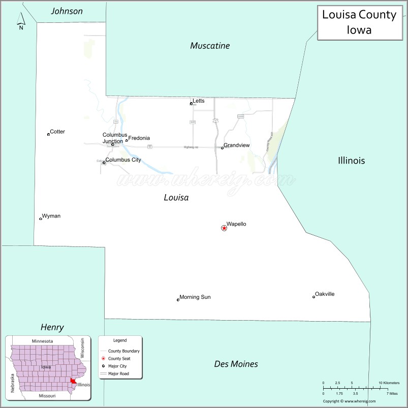
About Louisa County Map, Iowa: The map showing the county boundary, county seat, major cities, highways, water bodies and neighbouring counties.
More Iowa Maps & Info
| Iowa Map | Iowa County Map | Iowa Cities Map |
| Iowa Zip codes | Where is Iowa | Airports in Iowa |
| Iowa Area Codes | Iowa Blank Map | Iowa River Map |
| Iowa Physical Map | Iowa Road Map | Where is Des Moines |
Map of Louisa County, Iowa
Louisa County is a county located in the U.S. state of Iowa. It's county seat is Wapello. As per 2020 census, the population of Louisa County is 10749 people and population density is square miles. According to the United States Census Bureau, the county has a total area of 402 sq mi (1,041 km2). Louisa County was established on -23033.
Louisa County Facts
| Continent | North America |
| Country | United States |
| State | Iowa |
| County Seat | Wapello |
| Largest City/Town | Wapello |
| Established | December 7, 1836 |
| Total Area | 418 sq mi (1,083 sq km) |
| Land Area | 402 sq mi (1,041 sq km) |
| Water Area | 16 sq mi (41 sq km) |
| Population | 10,837 (Census 2020) |
| Population Density | 27.0 people per sq mi |
| Time Zone | Central Time Zone (CT) |
| Major Highways | U.S. Highway 61, Iowa Highway 70, Iowa Highway 78, Iowa Highway 92 |
| Major Rivers | Mississippi River, Iowa River, Cedar River |
| Neighboring Counties | Muscatine County, Johnson County, Washington County, Henry County, Des Moines County, Rock Island County (IL), Mercer County (IL) |
| Famous For | Port Louisa National Wildlife Refuge, Mississippi River, Toolesboro Indian Mounds, agricultural heritage |
| Top Attractions | Port Louisa National Wildlife Refuge, Toolesboro Mounds, Mississippi River recreation, Louisa County Historical Museum |
| Official Website | Official Website |
About Louisa County, Iowa
Louisa County is located in southeastern Iowa along the Mississippi River and was established in 1836. The county seat and largest city is Wapello. The county is known for its fertile farmland, river landscapes, wildlife refuges, and Native American archaeological sites. The Mississippi River forms much of the county's eastern boundary and provides important recreational and environmental resources. :contentReference[oaicite:0]{index=0}
Cities and Towns in Louisa County, Iowa
| City/Town | Population (Census 2020) | Latitude & Longitude |
|---|---|---|
| Wapello (county seat) | 2,084 | 41.1817°N, 91.1854°W |
| Columbus Junction | 1,830 | 41.2804°N, 91.3607°W |
| Morning Sun | 752 | 41.0955°N, 91.2579°W |
| Grandview | 437 | 41.2766°N, 91.1888°W |
| Columbus City | 392 | 41.2898°N, 91.3591°W |
| Letts | 362 | 41.3270°N, 91.2412°W |
| Fredonia | 222 | 41.3164°N, 91.2976°W |
| Oakville | 200 | 41.1018°N, 91.0530°W |
| Cotter | 39 | 41.3057°N, 91.4010°W |
| Toolesboro (CDP) | 123 | 41.1428°N, 91.1356°W |
| Cairo (CDP) | 67 | 41.2258°N, 91.1127°W |
Best Golf Courses in Louisa County, Iowa
| Golf Course | Location | Latitude & Longitude |
|---|---|---|
| Heritage Oaks Golf & Country Club | Wapello | 41.1868°N, 91.2076°W |
| Columbus Junction Golf Course | Columbus Junction | 41.2818°N, 91.3739°W |
| Morning Sun Golf Club | Morning Sun | 41.0998°N, 91.2651°W |
What are Major Roads and Highways in Louisa County
Major highways connect the county to nearby regions and cities.
- U.S. Highway 61 - north-south route connecting Muscatine, Wapello, and Burlington
- Iowa Highway 92 - east-west corridor linking Louisa County with Washington County and Muscatine County
- Iowa Highway 78 - route connecting Morning Sun, Wapello, and neighboring communities
- Iowa Highway 70 - serves northern portions of the county and connects with Columbus Junction
Neighboring Counties of Louisa County
- Muscatine County (north)
- Johnson County (northwest)
- Washington County (west)
- Henry County (southwest)
- Des Moines County (south)
- Rock Island County, Illinois (northeast)
- Mercer County, Illinois (east)
What are Top Attractions in Louisa County, Iowa
The county offers a mix of natural and cultural attractions.
| Main Sight Name | City | Famous For |
|---|---|---|
| Port Louisa National Wildlife Refuge | Wapello Area | Migratory birds, wetlands, and wildlife viewing |
| Toolesboro Indian Mounds National Historic Landmark | Toolesboro | Ancient Native American burial mounds |
| Louisa County Historical Museum | Wapello | Local history exhibits and pioneer artifacts |
| Mississippi River Scenic Areas | Oakville | River views, fishing, and boating |
| Cone Marsh Wildlife Area | Columbus Junction | Birdwatching and outdoor recreation |
| Heritage Oaks Golf & Country Club | Wapello | Golf and scenic countryside views |
| Morning Sun City Park | Morning Sun | Community recreation and events |
| Grandview Heritage District | Grandview | Historic small-town architecture |
| Columbus Junction Swinging Bridge Area | Columbus Junction | Historic local landmark and river scenery |
| Louisa County Fairgrounds | Wapello | Agricultural fairs and community events |
Distance from Louisa County to Nearby Cities
The following distances are measured by road (driving).
- Wapello to Columbus Junction (Louisa County), Iowa - 11 mi (18 km)
- Wapello to Morning Sun (Louisa County), Iowa - 14 mi (23 km)
- Wapello to Muscatine (Muscatine County), Iowa - 27 mi (43 km)
- Wapello to Washington (Washington County), Iowa - 32 mi (52 km)
- Wapello to Mount Pleasant (Henry County), Iowa - 27 mi (43 km)
- Wapello to Burlington (Des Moines County), Iowa - 31 mi (50 km)
- Wapello to Iowa City (Johnson County), Iowa - 45 mi (72 km)
- Wapello to Davenport (Scott County), Iowa - 57 mi (92 km)
- Wapello to Cedar Rapids (Linn County), Iowa - 72 mi (116 km)
- Wapello to Moline, Illinois - 50 mi (80 km)
- Wapello to Rock Island, Illinois - 52 mi (84 km)
- Wapello to Galesburg, Illinois - 61 mi (98 km)
- Wapello to Des Moines (Polk County), Iowa - 127 mi (204 km)
- Wapello to Peoria, Illinois - 106 mi (171 km)
- Wapello to Chicago, Illinois - 222 mi (357 km)
Nearest Airports
Nearest airport of Louisa is Southeast Iowa Regional Airport (BRL / KBRL).
References
- QuickFacts - U.S. Census Bureau
- United States Census Bureau
- United States Geological Survey (USGS)
- National Geodetic Survey
- Official Louisa County Website
- Adair County Map
- Adams County Map
- Allamakee County Map
- Appanoose County Map
- Audubon County Map
- Benton County Map
- Black Hawk County Map
- Boone County Map
- Bremer County Map
- Buchanan County Map
- Buena Vista County Map
- Butler County Map
- Calhoun County Map
- Carroll County Map
- Cass County Map
- Cedar County Map
- Cerro Gordo County Map
- Cherokee County Map
- Chickasaw County Map
- Clarke County Map
- Clay County Map
- Clayton County Map
- Clinton County Map
- Crawford County Map
- Dallas County Map
- Davis County Map
- Decatur County Map
- Delaware County Map
- Des Moines County Map
- Dickinson County Map
- Dubuque County Map
- Emmet County Map
- Fayette County Map
- Floyd County Map
- Franklin County Map
- Fremont County Map
- Greene County Map
- Grundy County Map
- Guthrie County Map
- Hamilton County Map
- Hancock County Map
- Hardin County Map
- Harrison County Map
- Henry County Map
- Howard County Map
- Humboldt County Map
- Ida County Map
- Iowa County Map
- Jackson County Map
- Jasper County Map
- Jefferson County Map
- Johnson County Map
- Jones County Map
- Keokuk County Map
- Kossuth County Map
- Lee County Map
- Linn County Map
- Louisa County Map
- Lucas County Map
- Lyon County Map
- Madison County Map
- Mahaska County Map
- Marion County Map
- Marshall County Map
- Mills County Map
- Mitchell County Map
- Monona County Map
- Monroe County Map
- Montgomery County Map
- Muscatine County Map
- O'Brien County Map
- Osceola County Map
- Page County Map
- Palo Alto County Map
- Plymouth County Map
- Pocahontas County Map
- Polk County Map
- Pottawattamie County Map
- Poweshiek County Map
- Ringgold County Map
- Sac County Map
- Scott County Map
- Shelby County Map
- Sioux County Map
- Story County Map
- Tama County Map
- Taylor County Map
- Union County Map
- Van Buren County Map
- Wapello County Map
- Warren County Map
- Washington County Map
- Wayne County Map
- Webster County Map
- Winnebago County Map
- Winneshiek County Map
- Woodbury County Map
- Worth County Map
- Wright County Map
- Alabama Counties
- Alaska boroughs
- Arizona Counties
- Arkansas Counties
- California County Map
- Colorado Counties
- Connecticut Counties
- Delaware Counties
- Florida County Map
- Georgia County Map
- Hawaii Counties
- Idaho Counties
- Illinois Counties
- Indiana Counties
- Iowa Counties
- Kansas Counties
- Kentucky Counties
- Louisiana Counties
- Maine Counties
- Maryland Counties
- Massachusetts Counties
- Michigan County Map
- Minnesota Counties
- Mississippi Counties
- Missouri Counties
- Montana Counties
- Nebraska Counties
- Nevada Counties
- New York Counties
- New Hampshire Counties
- New Jersey Counties
- New Mexico Counties
- North Carolina Counties
- North Dakota Counties
- Ohio County Map
- Oklahoma Counties
- Oregon Counties
- Pennsylvania Counties
- Rhode Island Counties
- South Carolina Counties
- South Dakota Counties
- Map of Tennessee
- Texas County Map
- Utah Counties
- Vermont Counties
- Virginia Counties
- Washington Counties
- West Virginia Counties
- Wisconsin Counties
- Wyoming Counties