Written and Fact-checked by Whereig Editors | Last Updated On: June 10, 2026
Map of Chickasaw County - Chickasaw County is a county located in the U.S. state of Iowa. Chickasaw County Map showing cities, highways, important places and water bodies. Get Where is Chickasaw County located in the map, major cities in Chickasaw county, population, areas, and places of interest.
Chickasaw County Map, Iowa
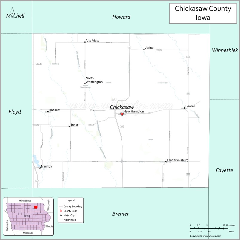
About Chickasaw County Map, Iowa: The map showing the county boundary, county seat, major cities, highways, water bodies and neighbouring counties.
More Iowa Maps & Info
| Iowa Map | Iowa County Map | Iowa Cities Map |
| Iowa Zip codes | Where is Iowa | Airports in Iowa |
| Iowa Area Codes | Iowa Blank Map | Iowa River Map |
| Iowa Physical Map | Iowa Road Map | Where is Des Moines |
Map of Chickasaw County, Iowa
Chickasaw County is a county located in the U.S. state of Iowa. It's county seat is New Hampton. As per 2020 census, the population of Chickasaw County is 11887 people and population density is square miles. According to the United States Census Bureau, the county has a total area of 505 sq mi (1,308 km2). Chickasaw County was established on -17881.
Chickasaw County Facts
| Continent | North America |
| Country | United States |
| State | Iowa |
| County Seat | New Hampton |
| Largest City/Town | New Hampton |
| Established | January 15, 1851 |
| Total Area | 505 sq mi (1,308 sq km) |
| Land Area | 504 sq mi (1,305 sq km) |
| Water Area | 1 sq mi (3 sq km) |
| Population | 12,012 (Census 2020) |
| Population Density | 23.8 people per sq mi |
| Time Zone | Central Time Zone (CT) |
| Major Highways | U.S. Highway 18, U.S. Highway 63, Iowa Highway 24, Iowa Highway 27 |
| Major Rivers | Little Cedar River, Wapsipinicon River |
| Neighboring Counties | Howard County, Winneshiek County, Fayette County, Bremer County, Butler County, Floyd County |
| Famous For | New Hampton, Little Brown Church nearby region, agriculture, Little Cedar River Valley |
| Top Attractions | Chickasaw County Heritage Center, Mikkelson Park, New Hampton Trail System, Crane Creek Recreation Area |
| Official Website | Official Website |
About Chickasaw County, Iowa
Chickasaw County is located in northeastern Iowa and was established in 1851. The county seat is New Hampton, which is also the largest city. The county features fertile farmland, scenic river valleys, and welcoming small communities. Agriculture remains the primary economic driver, while recreation areas along the Little Cedar and Wapsipinicon rivers provide outdoor opportunities throughout the county.
Cities and Towns in Chickasaw County, Iowa
| City Name | Type | Population (2020) | Pop. Density | Area | Incorporated |
|---|---|---|---|---|---|
| Alta Vista | 227 | 0.76 sq mi (2 km2) | September 18, 1894 | ||
| Bassett | 45 | 0.37 sq mi (0.96 km2) | November 7, 1896 | ||
| Fredericksburg | 0.86 sq mi (2.2 km2) | December 18, 1894 | |||
| Ionia | 0.55 sq mi (1.4 km2) | April 23, 1891 | |||
| Lawler | 0.88 sq mi (2.3 km2) | April 28, 1873 | |||
| New Hampton | 3.16 sq mi (8.2 km2) | April 26, 1873 | |||
| North Washington | 0.2 sq mi (0.52 km2) | April 16, 1904 | |||
| Nashua | 2.88 sq mi (7.5 km2) | January 29, 1857 | |||
| Protivin | 0.48 sq mi (1.2 km2) | August 1, 1894 |
Best Golf Courses in Chickasaw County, Iowa
| Golf Course | Location | Latitude & Longitude |
|---|---|---|
| New Hampton Golf & Country Club | New Hampton | 43.0476°N, 92.3217°W |
| Nashua Town & Country Club | Nashua | 42.9458°N, 92.5298°W |
| Fredericksburg Golf Course | Fredericksburg | 42.9587°N, 92.2072°W |
What are Major Roads and Highways in Chickasaw County
Major highways connect the county to nearby regions and cities.
- U.S. Highway 18 - major east-west route connecting New Hampton with Charles City, Decorah and surrounding communities
- U.S. Highway 63 - north-south corridor linking New Hampton with Waterloo, Rochester and Mason City
- Iowa Highway 24 - serves southern Chickasaw County and connects Nashua with neighboring counties
- Iowa Highway 27 (Avenue of the Saints) - regional transportation route providing access across eastern Iowa
Neighboring Counties of Chickasaw County
- Howard County (north)
- Winneshiek County (northeast)
- Fayette County (southeast)
- Bremer County (south)
- Butler County (southwest)
- Floyd County (west)
What are Top Attractions in Chickasaw County, Iowa
The county offers a mix of natural and cultural attractions.
| Main Sight Name | City | Famous For |
|---|---|---|
| Chickasaw County Heritage Center | New Hampton | County history museum and pioneer exhibits |
| Mikkelson Park | New Hampton | Recreation facilities, trails and community events |
| Crane Creek Recreation Area | New Hampton | Camping, fishing and outdoor recreation |
| New Hampton Trail System | New Hampton | Walking and cycling opportunities |
| Nashua River Park | Nashua | Little Cedar River access and recreation |
| Fredericksburg Historical Museum | Fredericksburg | Local history and community heritage |
| Little Cedar River Corridor | Countywide | Fishing, kayaking and wildlife viewing |
| Alta Vista Community Park | Alta Vista | Outdoor recreation and family activities |
| Lawler Historical District | Lawler | Historic churches and small-town heritage |
| Jackson Junction Heritage Site | Jackson Junction | Norwegian immigrant history |
| Ionia Community Park | Ionia | Picnic areas and local events |
| Wapsipinicon River Recreation Area | Countywide | Scenic river landscapes and wildlife habitat |
Distance from Chickasaw County to Nearby Cities
The following distances are measured by road (driving).
- New Hampton to Charles City (Floyd County), Iowa - 17 mi (27 km)
- New Hampton to Waverly (Bremer County), Iowa - 28 mi (45 km)
- New Hampton to Decorah (Winneshiek County), Iowa - 33 mi (53 km)
- New Hampton to Cresco (Howard County), Iowa - 25 mi (40 km)
- New Hampton to Oelwein (Fayette County), Iowa - 29 mi (47 km)
- New Hampton to Allison (Butler County), Iowa - 35 mi (56 km)
- New Hampton to Mason City (Cerro Gordo County), Iowa - 36 mi (58 km)
- New Hampton to Waterloo (Black Hawk County), Iowa - 49 mi (79 km)
- New Hampton to Cedar Falls (Black Hawk County), Iowa - 52 mi (84 km)
- New Hampton to Dubuque (Dubuque County), Iowa - 88 mi (142 km)
- New Hampton to Rochester, Minnesota - 71 mi (114 km)
- New Hampton to Cedar Rapids (Linn County), Iowa - 90 mi (145 km)
- New Hampton to La Crosse, Wisconsin - 95 mi (153 km)
- New Hampton to Ames (Story County), Iowa - 105 mi (169 km)
- New Hampton to Des Moines (Polk County), Iowa - 142 mi (229 km)
Nearest Airports
Nearest airport of Chickasaw is Waterloo Regional Airport (ALO / KALO).
References
- QuickFacts - U.S. Census Bureau
- United States Census Bureau
- United States Geological Survey (USGS)
- National Geodetic Survey
- Official County Website
- Adair County Map
- Adams County Map
- Allamakee County Map
- Appanoose County Map
- Audubon County Map
- Benton County Map
- Black Hawk County Map
- Boone County Map
- Bremer County Map
- Buchanan County Map
- Buena Vista County Map
- Butler County Map
- Calhoun County Map
- Carroll County Map
- Cass County Map
- Cedar County Map
- Cerro Gordo County Map
- Cherokee County Map
- Chickasaw County Map
- Clarke County Map
- Clay County Map
- Clayton County Map
- Clinton County Map
- Crawford County Map
- Dallas County Map
- Davis County Map
- Decatur County Map
- Delaware County Map
- Des Moines County Map
- Dickinson County Map
- Dubuque County Map
- Emmet County Map
- Fayette County Map
- Floyd County Map
- Franklin County Map
- Fremont County Map
- Greene County Map
- Grundy County Map
- Guthrie County Map
- Hamilton County Map
- Hancock County Map
- Hardin County Map
- Harrison County Map
- Henry County Map
- Howard County Map
- Humboldt County Map
- Ida County Map
- Iowa County Map
- Jackson County Map
- Jasper County Map
- Jefferson County Map
- Johnson County Map
- Jones County Map
- Keokuk County Map
- Kossuth County Map
- Lee County Map
- Linn County Map
- Louisa County Map
- Lucas County Map
- Lyon County Map
- Madison County Map
- Mahaska County Map
- Marion County Map
- Marshall County Map
- Mills County Map
- Mitchell County Map
- Monona County Map
- Monroe County Map
- Montgomery County Map
- Muscatine County Map
- O'Brien County Map
- Osceola County Map
- Page County Map
- Palo Alto County Map
- Plymouth County Map
- Pocahontas County Map
- Polk County Map
- Pottawattamie County Map
- Poweshiek County Map
- Ringgold County Map
- Sac County Map
- Scott County Map
- Shelby County Map
- Sioux County Map
- Story County Map
- Tama County Map
- Taylor County Map
- Union County Map
- Van Buren County Map
- Wapello County Map
- Warren County Map
- Washington County Map
- Wayne County Map
- Webster County Map
- Winnebago County Map
- Winneshiek County Map
- Woodbury County Map
- Worth County Map
- Wright County Map
- Alabama Counties
- Alaska boroughs
- Arizona Counties
- Arkansas Counties
- California County Map
- Colorado Counties
- Connecticut Counties
- Delaware Counties
- Florida County Map
- Georgia County Map
- Hawaii Counties
- Idaho Counties
- Illinois Counties
- Indiana Counties
- Iowa Counties
- Kansas Counties
- Kentucky Counties
- Louisiana Counties
- Maine Counties
- Maryland Counties
- Massachusetts Counties
- Michigan County Map
- Minnesota Counties
- Mississippi Counties
- Missouri Counties
- Montana Counties
- Nebraska Counties
- Nevada Counties
- New York Counties
- New Hampshire Counties
- New Jersey Counties
- New Mexico Counties
- North Carolina Counties
- North Dakota Counties
- Ohio County Map
- Oklahoma Counties
- Oregon Counties
- Pennsylvania Counties
- Rhode Island Counties
- South Carolina Counties
- South Dakota Counties
- Map of Tennessee
- Texas County Map
- Utah Counties
- Vermont Counties
- Virginia Counties
- Washington Counties
- West Virginia Counties
- Wisconsin Counties
- Wyoming Counties