Written and Fact-checked by Whereig Editors | Last Updated On: June 10, 2026
Map of Washington County - Washington County is a county located in the U.S. state of Iowa. Washington County Map showing cities, highways, important places and water bodies. Get Where is Washington County located in the map, major cities in Washington county, population, areas, and places of interest.
Washington County Map, Iowa
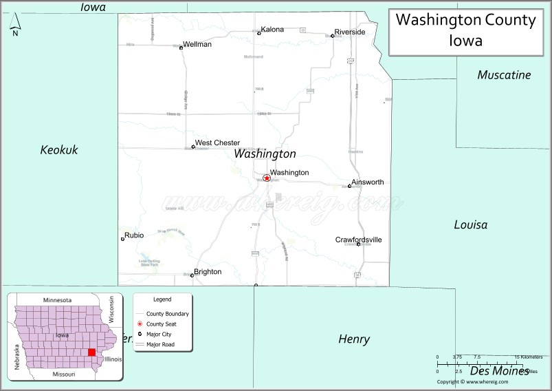
About Washington County Map, Iowa: The map showing the county boundary, county seat, major cities, highways, water bodies and neighbouring counties.
More Iowa Maps & Info
| Iowa Map | Iowa County Map | Iowa Cities Map |
| Iowa Zip codes | Where is Iowa | Airports in Iowa |
| Iowa Area Codes | Iowa Blank Map | Iowa River Map |
| Iowa Physical Map | Iowa Road Map | Where is Des Moines |
Map of Washington County, Iowa
Washington County is a county located in the U.S. state of Iowa. It's county seat is Washington. As per 2020 census, the population of Washington County is 22491 people and population density is square miles. According to the United States Census Bureau, the county has a total area of 569 sq mi (1,474 km2). Washington County was established on -22254.
Washington County Facts
| Continent | North America |
| Country | United States |
| State | Iowa |
| County Seat | Washington |
| Largest City/Town | Washington |
| Established | February 17, 1838 |
| Total Area | 569 sq mi (1,474 sq km) |
| Land Area | 569 sq mi (1,474 sq km) |
| Water Area | 0.3 sq mi (0.8 sq km) |
| Population | 22,190 (Census 2020) |
| Population Density | 39.0 people per sq mi |
| Time Zone | Central Time Zone (CT) |
| Major Highways | U.S. Highway 218, Iowa Highway 1, Iowa Highway 22, Iowa Highway 92 |
| Major Rivers | English River, Skunk River, Crooked Creek |
| Neighboring Counties | Johnson County, Louisa County, Henry County, Jefferson County, Keokuk County, Iowa County |
| Famous For | Washington, Kalona Amish community, agriculture, manufacturing, historic downtown districts |
| Top Attractions | Kalona Historical Village, Riverside Casino & Golf Resort, Washington Square, Marr Park |
| Official Website | Official Website |
About Washington County, Iowa
Washington County is located in southeastern Iowa and was established in 1838. The county seat and largest city is Washington. The county is known for its strong agricultural economy, Amish and Mennonite heritage around Kalona, manufacturing industries, and historic communities. Washington County serves as an important economic and cultural center between Iowa City and the Mississippi River region.
Cities and Towns in Washington County, Iowa
| City/Town | Population (Census 2020) | Latitude & Longitude |
|---|---|---|
| Washington (county seat) | 7,352 | 41.3014°N, 91.6929°W |
| Kalona (partly) | 2,458 | 41.4847°N, 91.7066°W |
| Riverside (partly) | 1,114 | 41.4792°N, 91.5782°W |
| Ainsworth | 523 | 41.2864°N, 91.5524°W |
| Crawfordsville | 281 | 41.2289°N, 91.5391°W |
| Brighton | 652 | 41.1744°N, 91.8191°W |
| Wellman | 1,524 | 41.4644°N, 91.8385°W |
| West Chester | 146 | 41.3381°N, 91.8116°W |
| Keota (partly) | 1,019 | 41.3631°N, 91.9627°W |
| Richland (partly) | 587 | 41.1944°N, 91.9941°W |
Best Golf Courses in Washington County, Iowa
| Golf Course | Location | Latitude & Longitude |
|---|---|---|
| Riverside Casino & Golf Resort - Blue Top Ridge | Riverside | 41.4972°N, 91.5856°W |
| Washington Golf & Country Club | Washington | 41.3067°N, 91.7064°W |
| Kalona Golf Club | Kalona | 41.4878°N, 91.7211°W |
| Wellman Golf Course | Wellman | 41.4686°N, 91.8467°W |
What are Major Roads and Highways in Washington County
Washington County is served by major highways that connect southeastern Iowa communities and regional markets.
- U.S. Highway 218 - major north-south corridor connecting Iowa City and Mount Pleasant
- Iowa Highway 1 - scenic route through Washington and Kalona
- Iowa Highway 22 - east-west route serving northern portions of the county
- Iowa Highway 92 - major east-west highway crossing southern Washington County
Neighboring Counties of Washington County
- Johnson County (north)
- Iowa County (northwest)
- Louisa County (east)
- Henry County (southeast)
- Jefferson County (southwest)
- Keokuk County (west)
What are Top Attractions in Washington County, Iowa
Washington County offers a combination of cultural heritage, outdoor recreation, and historic attractions.
| Main Sight Name | City | Famous For |
|---|---|---|
| Kalona Historical Village | Kalona | Amish and Mennonite heritage exhibits |
| Riverside Casino & Golf Resort | Riverside | Gaming, entertainment, golf, and resort accommodations |
| Washington Square | Washington | Historic downtown district and courthouse square |
| Marr Park | Ainsworth | Camping, fishing, hiking, and environmental education |
| Central Park | Washington | Community events and outdoor recreation |
| Washington County Historical Society Museum | Washington | Local history and pioneer collections |
| Kalona Cheese Factory Area | Kalona | Traditional Amish food and local products |
| Wellman Heritage Museum | Wellman | Community history and cultural exhibits |
| Crawfordsville Community Park | Crawfordsville | Family recreation and outdoor activities |
| English River Corridor | Countywide | Wildlife viewing and scenic landscapes |
| Washington County Fairgrounds | Washington | Agricultural fairs and annual events |
| Amish Countryside Tours | Kalona Area | Rural heritage, crafts, and traditional farming culture |
Distance from Washington County to Nearby Cities
The following distances are measured by road (driving) from Washington.
- Washington to Kalona (Washington County), Iowa - 14 mi (23 km)
- Washington to Wellman (Washington County), Iowa - 11 mi (18 km)
- Washington to Riverside (Washington County), Iowa - 18 mi (29 km)
- Washington to Brighton (Washington County), Iowa - 13 mi (21 km)
- Washington to Iowa City (Johnson County), Iowa - 34 mi (55 km)
- Washington to Wapello (Louisa County), Iowa - 27 mi (43 km)
- Washington to Mount Pleasant (Henry County), Iowa - 26 mi (42 km)
- Washington to Fairfield (Jefferson County), Iowa - 32 mi (52 km)
- Washington to Sigourney (Keokuk County), Iowa - 25 mi (40 km)
- Washington to Marengo (Iowa County), Iowa - 33 mi (53 km)
- Washington to Cedar Rapids (Linn County), Iowa - 60 mi (97 km)
- Washington to Davenport (Scott County), Iowa - 74 mi (119 km)
- Washington to Des Moines (Polk County), Iowa - 117 mi (188 km)
- Washington to Burlington (Des Moines County), Iowa - 54 mi (87 km)
- Washington to Chicago, Illinois - 228 mi (367 km)
References
- U.S. Census Bureau - Washington County QuickFacts
- Washington County Official Website
- City of Washington
- United States Geological Survey (USGS)
- National Geodetic Survey (NGS)
- Adair County Map
- Adams County Map
- Allamakee County Map
- Appanoose County Map
- Audubon County Map
- Benton County Map
- Black Hawk County Map
- Boone County Map
- Bremer County Map
- Buchanan County Map
- Buena Vista County Map
- Butler County Map
- Calhoun County Map
- Carroll County Map
- Cass County Map
- Cedar County Map
- Cerro Gordo County Map
- Cherokee County Map
- Chickasaw County Map
- Clarke County Map
- Clay County Map
- Clayton County Map
- Clinton County Map
- Crawford County Map
- Dallas County Map
- Davis County Map
- Decatur County Map
- Delaware County Map
- Des Moines County Map
- Dickinson County Map
- Dubuque County Map
- Emmet County Map
- Fayette County Map
- Floyd County Map
- Franklin County Map
- Fremont County Map
- Greene County Map
- Grundy County Map
- Guthrie County Map
- Hamilton County Map
- Hancock County Map
- Hardin County Map
- Harrison County Map
- Henry County Map
- Howard County Map
- Humboldt County Map
- Ida County Map
- Iowa County Map
- Jackson County Map
- Jasper County Map
- Jefferson County Map
- Johnson County Map
- Jones County Map
- Keokuk County Map
- Kossuth County Map
- Lee County Map
- Linn County Map
- Louisa County Map
- Lucas County Map
- Lyon County Map
- Madison County Map
- Mahaska County Map
- Marion County Map
- Marshall County Map
- Mills County Map
- Mitchell County Map
- Monona County Map
- Monroe County Map
- Montgomery County Map
- Muscatine County Map
- O'Brien County Map
- Osceola County Map
- Page County Map
- Palo Alto County Map
- Plymouth County Map
- Pocahontas County Map
- Polk County Map
- Pottawattamie County Map
- Poweshiek County Map
- Ringgold County Map
- Sac County Map
- Scott County Map
- Shelby County Map
- Sioux County Map
- Story County Map
- Tama County Map
- Taylor County Map
- Union County Map
- Van Buren County Map
- Wapello County Map
- Warren County Map
- Washington County Map
- Wayne County Map
- Webster County Map
- Winnebago County Map
- Winneshiek County Map
- Woodbury County Map
- Worth County Map
- Wright County Map
- Alabama Counties
- Alaska boroughs
- Arizona Counties
- Arkansas Counties
- California County Map
- Colorado Counties
- Connecticut Counties
- Delaware Counties
- Florida County Map
- Georgia County Map
- Hawaii Counties
- Idaho Counties
- Illinois Counties
- Indiana Counties
- Iowa Counties
- Kansas Counties
- Kentucky Counties
- Louisiana Counties
- Maine Counties
- Maryland Counties
- Massachusetts Counties
- Michigan County Map
- Minnesota Counties
- Mississippi Counties
- Missouri Counties
- Montana Counties
- Nebraska Counties
- Nevada Counties
- New York Counties
- New Hampshire Counties
- New Jersey Counties
- New Mexico Counties
- North Carolina Counties
- North Dakota Counties
- Ohio County Map
- Oklahoma Counties
- Oregon Counties
- Pennsylvania Counties
- Rhode Island Counties
- South Carolina Counties
- South Dakota Counties
- Map of Tennessee
- Texas County Map
- Utah Counties
- Vermont Counties
- Virginia Counties
- Washington Counties
- West Virginia Counties
- Wisconsin Counties
- Wyoming Counties