Written and Fact-checked by Whereig Editors | Last Updated On: June 10, 2026
Map of Pottawattamie County - Pottawattamie County is a county located in the U.S. state of Iowa. Pottawattamie County Map showing cities, highways, important places and water bodies. Get Where is Pottawattamie County located in the map, major cities in Pottawattamie county, population, areas, and places of interest.
Pottawattamie County Map, Iowa
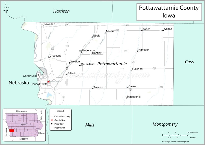
About Pottawattamie County Map, Iowa: The map showing the county boundary, county seat, major cities, highways, water bodies and neighbouring counties.
More Iowa Maps & Info
| Iowa Map | Iowa County Map | Iowa Cities Map |
| Iowa Zip codes | Where is Iowa | Airports in Iowa |
| Iowa Area Codes | Iowa Blank Map | Iowa River Map |
| Iowa Physical Map | Iowa Road Map | Where is Des Moines |
Map of Pottawattamie County, Iowa
Pottawattamie County is a county located in the U.S. state of Iowa. It's county seat is Council Bluffs. As per 2020 census, the population of Pottawattamie County is 93304 people and population density is square miles. According to the United States Census Bureau, the county has a total area of 954 sq mi (2,471 km2). Pottawattamie County was established on -19302.
Pottawattamie County Facts
| Continent | North America |
| Country | United States |
| State | Iowa |
| County Seat | Council Bluffs |
| Largest City/Town | Council Bluffs |
| Established | February 24, 1847 |
| Total Area | 960 sq mi (2,486 sq km) |
| Land Area | 950 sq mi (2,461 sq km) |
| Water Area | 10 sq mi (25 sq km) |
| Population | 93,667 (Census 2020) |
| Population Density | 98.6 people per sq mi |
| Time Zone | Central Time Zone (CT) |
| Major Highways | Interstate 29, Interstate 80, Interstate 680, U.S. Highway 6, U.S. Highway 59, U.S. Highway 275, U.S. Highway 34, Iowa Highway 92 |
| Major Rivers | Missouri River, Nishnabotna River, Mosquito Creek |
| Neighboring Counties | Harrison County, Shelby County, Cass County, Mills County, Douglas County (NE), Sarpy County (NE), Washington County (NE) |
| Famous For | Council Bluffs, Missouri River, Union Pacific Railroad, Loess Hills, Omaha metropolitan area |
| Top Attractions | Union Pacific Railroad Museum, Lake Manawa State Park, Hitchcock Nature Center, Bob Kerrey Pedestrian Bridge |
| Official Website | Official Website |
About Pottawattamie County, Iowa
Pottawattamie County is located in western Iowa along the Missouri River and was established in 1847. The county seat and largest city is Council Bluffs. As part of the Omaha-Council Bluffs metropolitan area, the county serves as an important transportation, business, and cultural hub. The county is known for its railroad heritage, scenic Loess Hills, and role in westward expansion.
Cities and Towns in Pottawattamie County, Iowa
| City/Town | Population (Census 2020) | Latitude & Longitude |
|---|---|---|
| Council Bluffs (county seat) | 62,799 | 41.2619°N, 95.8608°W |
| Carter Lake | 3,791 | 41.2844°N, 95.9183°W |
| Avoca | 1,369 | 41.4769°N, 95.3386°W |
| Treynor | 1,083 | 41.2328°N, 95.6144°W |
| Oakland | 1,369 | 41.3094°N, 95.3961°W |
| Underwood | 917 | 41.3892°N, 95.6769°W |
| Walnut | 778 | 41.4761°N, 95.2228°W |
| Neola | 842 | 41.4494°N, 95.6203°W |
| Crescent | 617 | 41.3644°N, 95.8586°W |
| Minden | 599 | 41.4689°N, 95.5469°W |
| McClelland | 131 | 41.3161°N, 95.6742°W |
| Carson (partly) | 812 | 41.2339°N, 95.4186°W |
| Hancock (partly) | 176 | 41.3894°N, 95.3656°W |
Best Golf Courses in Pottawattamie County, Iowa
| Golf Course | Location | Latitude & Longitude |
|---|---|---|
| Dodge Riverside Golf Club | Council Bluffs | 41.2532°N, 95.8897°W |
| Bent Tree Golf Club | Council Bluffs | 41.3004°N, 95.8126°W |
| Council Bluffs Country Club | Council Bluffs | 41.2741°N, 95.7923°W |
| American Legion Country Club | Avoca | 41.4815°N, 95.3478°W |
What are Major Roads and Highways in Pottawattamie County
Major highways make the county one of Iowa's most important transportation centers.
- Interstate 29 - major north-south route along the Missouri River corridor
- Interstate 80 - major transcontinental east-west interstate
- Interstate 680 - bypass route connecting Iowa and Nebraska
- U.S. Highways 6, 34, 59, and 275 - important regional transportation corridors
- Iowa Highway 92 - connects Council Bluffs with communities to the east
Neighboring Counties of Pottawattamie County
- Harrison County (north)
- Shelby County (northeast)
- Cass County (east)
- Mills County (south)
- Douglas County, Nebraska (west)
- Sarpy County, Nebraska (west)
- Washington County, Nebraska (northwest)
What are Top Attractions in Pottawattamie County, Iowa
The county offers a mix of historical, cultural, and outdoor attractions.
| Main Sight Name | City | Famous For |
|---|---|---|
| Union Pacific Railroad Museum | Council Bluffs | Railroad history and interactive exhibits |
| Lake Manawa State Park | Council Bluffs | Boating, camping, fishing, and recreation |
| Hitchcock Nature Center | Honey Creek | Loess Hills hiking and wildlife observation |
| Bob Kerrey Pedestrian Bridge | Council Bluffs | Bridge connecting Iowa and Nebraska |
| Lewis and Clark Monument | Council Bluffs | Historic expedition overlook |
| Mid-America Center | Council Bluffs | Concerts, sports, and conventions |
| Western Historic Trails Center | Council Bluffs | Oregon, Mormon, and California trail history |
| Loess Hills Scenic Byway | Countywide | Unique geological formations and scenic drives |
| Historic Squirrel Cage Jail | Council Bluffs | Rare rotating jail structure |
| Avoca Main Street District | Avoca | Historic downtown and local businesses |
| Walnut Antique City | Walnut | Antique shops and annual festivals |
| Pottawattamie County Fairgrounds | Avoca | Agricultural fairs and community events |
Distance from Pottawattamie County to Nearby Cities
The following distances are measured by road (driving) from Council Bluffs.
- Council Bluffs to Carter Lake (Pottawattamie County), Iowa - 4 mi (6 km)
- Council Bluffs to Treynor (Pottawattamie County), Iowa - 12 mi (19 km)
- Council Bluffs to Oakland (Pottawattamie County), Iowa - 20 mi (32 km)
- Council Bluffs to Avoca (Pottawattamie County), Iowa - 39 mi (63 km)
- Council Bluffs to Underwood (Pottawattamie County), Iowa - 11 mi (18 km)
- Council Bluffs to Logan (Harrison County), Iowa - 27 mi (43 km)
- Council Bluffs to Harlan (Shelby County), Iowa - 45 mi (72 km)
- Council Bluffs to Atlantic (Cass County), Iowa - 52 mi (84 km)
- Council Bluffs to Glenwood (Mills County), Iowa - 20 mi (32 km)
- Council Bluffs to Omaha, Nebraska - 4 mi (6 km)
- Council Bluffs to Lincoln, Nebraska - 58 mi (93 km)
- Council Bluffs to Sioux City (Woodbury County), Iowa - 99 mi (159 km)
- Council Bluffs to Des Moines (Polk County), Iowa - 135 mi (217 km)
- Council Bluffs to Cedar Rapids (Linn County), Iowa - 255 mi (410 km)
- Council Bluffs to Kansas City, Missouri - 189 mi (304 km)
Nearest Airports
Nearest airport of Pottawattamie is Council Bluffs Municipal Airport.
References
- QuickFacts - U.S. Census Bureau
- United States Census Bureau
- United States Geological Survey (USGS)
- National Geodetic Survey
- Official Pottawattamie County Website
- Adair County Map
- Adams County Map
- Allamakee County Map
- Appanoose County Map
- Audubon County Map
- Benton County Map
- Black Hawk County Map
- Boone County Map
- Bremer County Map
- Buchanan County Map
- Buena Vista County Map
- Butler County Map
- Calhoun County Map
- Carroll County Map
- Cass County Map
- Cedar County Map
- Cerro Gordo County Map
- Cherokee County Map
- Chickasaw County Map
- Clarke County Map
- Clay County Map
- Clayton County Map
- Clinton County Map
- Crawford County Map
- Dallas County Map
- Davis County Map
- Decatur County Map
- Delaware County Map
- Des Moines County Map
- Dickinson County Map
- Dubuque County Map
- Emmet County Map
- Fayette County Map
- Floyd County Map
- Franklin County Map
- Fremont County Map
- Greene County Map
- Grundy County Map
- Guthrie County Map
- Hamilton County Map
- Hancock County Map
- Hardin County Map
- Harrison County Map
- Henry County Map
- Howard County Map
- Humboldt County Map
- Ida County Map
- Iowa County Map
- Jackson County Map
- Jasper County Map
- Jefferson County Map
- Johnson County Map
- Jones County Map
- Keokuk County Map
- Kossuth County Map
- Lee County Map
- Linn County Map
- Louisa County Map
- Lucas County Map
- Lyon County Map
- Madison County Map
- Mahaska County Map
- Marion County Map
- Marshall County Map
- Mills County Map
- Mitchell County Map
- Monona County Map
- Monroe County Map
- Montgomery County Map
- Muscatine County Map
- O'Brien County Map
- Osceola County Map
- Page County Map
- Palo Alto County Map
- Plymouth County Map
- Pocahontas County Map
- Polk County Map
- Pottawattamie County Map
- Poweshiek County Map
- Ringgold County Map
- Sac County Map
- Scott County Map
- Shelby County Map
- Sioux County Map
- Story County Map
- Tama County Map
- Taylor County Map
- Union County Map
- Van Buren County Map
- Wapello County Map
- Warren County Map
- Washington County Map
- Wayne County Map
- Webster County Map
- Winnebago County Map
- Winneshiek County Map
- Woodbury County Map
- Worth County Map
- Wright County Map
- Alabama Counties
- Alaska boroughs
- Arizona Counties
- Arkansas Counties
- California County Map
- Colorado Counties
- Connecticut Counties
- Delaware Counties
- Florida County Map
- Georgia County Map
- Hawaii Counties
- Idaho Counties
- Illinois Counties
- Indiana Counties
- Iowa Counties
- Kansas Counties
- Kentucky Counties
- Louisiana Counties
- Maine Counties
- Maryland Counties
- Massachusetts Counties
- Michigan County Map
- Minnesota Counties
- Mississippi Counties
- Missouri Counties
- Montana Counties
- Nebraska Counties
- Nevada Counties
- New York Counties
- New Hampshire Counties
- New Jersey Counties
- New Mexico Counties
- North Carolina Counties
- North Dakota Counties
- Ohio County Map
- Oklahoma Counties
- Oregon Counties
- Pennsylvania Counties
- Rhode Island Counties
- South Carolina Counties
- South Dakota Counties
- Map of Tennessee
- Texas County Map
- Utah Counties
- Vermont Counties
- Virginia Counties
- Washington Counties
- West Virginia Counties
- Wisconsin Counties
- Wyoming Counties