Written and Fact-checked by Whereig Editors | Last Updated On: June 10, 2026
Map of Guthrie County - Guthrie County is a county located in the U.S. state of Iowa. Guthrie County Map showing cities, highways, important places and water bodies. Get Where is Guthrie County located in the map, major cities in Guthrie county, population, areas, and places of interest.
Guthrie County Map, Iowa
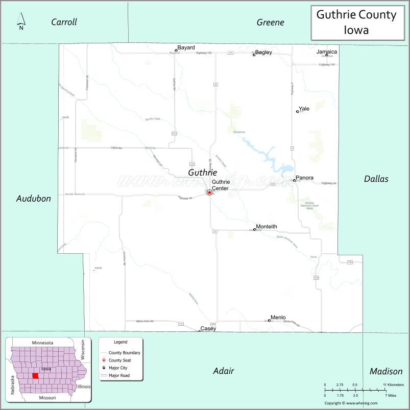
About Guthrie County Map, Iowa: The map showing the county boundary, county seat, major cities, highways, water bodies and neighbouring counties.
More Iowa Maps & Info
| Iowa Map | Iowa County Map | Iowa Cities Map |
| Iowa Zip codes | Where is Iowa | Airports in Iowa |
| Iowa Area Codes | Iowa Blank Map | Iowa River Map |
| Iowa Physical Map | Iowa Road Map | Where is Des Moines |
Map of Guthrie County, Iowa
Guthrie County is a county located in the U.S. state of Iowa. It's county seat is Guthrie Center. As per 2020 census, the population of Guthrie County is 10567 people and population density is square miles. According to the United States Census Bureau, the county has a total area of 591 sq mi (1,531 km2). Guthrie County was established on -17707.
Guthrie County Facts
| Continent | North America |
| Country | United States |
| State | Iowa |
| County Seat | Guthrie Center |
| Largest City/Town | Panora |
| Established | January 15, 1851 |
| Total Area | 593 sq mi (1,536 sq km) |
| Land Area | 591 sq mi (1,531 sq km) |
| Water Area | 2 sq mi (5 sq km) |
| Population | 10,623 (Census 2020) |
| Population Density | 18.0 people per sq mi |
| Time Zone | Central Time Zone (CT) |
| Major Highways | U.S. Highway 44, Iowa Highway 4, Iowa Highway 25, Iowa Highway 141 |
| Major Rivers | South Raccoon River, Middle Raccoon River, North Raccoon River |
| Neighboring Counties | Greene County, Dallas County, Adair County, Cass County, Audubon County, Carroll County |
| Famous For | Lake Panorama, historic small towns, Raccoon River Valley, outdoor recreation |
| Top Attractions | Lake Panorama, Whiterock Conservancy, Guthrie County Historical Village, Springbrook State Park |
| Official Website | Official Website |
About Guthrie County, Iowa
Guthrie County is located in west-central Iowa and was established in 1851. The county seat is Guthrie Center, while Panora is the largest community. The county is known for its rolling countryside, scenic river valleys, and Lake Panorama, one of Iowa's largest private lakes. Agriculture, recreation, and tourism play important roles in the local economy, while several historic communities preserve the county's rich heritage.
Cities and Towns in Guthrie County, Iowa
| City/Town | Population (Census 2020) | Latitude & Longitude |
|---|---|---|
| Guthrie Center (county seat) | 1,569 | 41.6776°N, 94.5030°W |
| Panora | 1,142 | 41.6914°N, 94.3636°W |
| Bayard | 405 | 41.8516°N, 94.5575°W |
| Casey | 387 | 41.5053°N, 94.5194°W |
| Jamaica | 208 | 41.8780°N, 94.3066°W |
| Menlo | 345 | 41.5189°N, 94.4044°W |
| Stuart (part) | 1,648 | 41.5003°N, 94.3183°W |
| Yale | 246 | 41.7744°N, 94.3558°W |
| Bagley | 283 | 41.8472°N, 94.4305°W |
| Coon Rapids (part) | 1,305 | 41.8703°N, 94.6783°W |
| Linden | 191 | 41.6420°N, 94.2730°W |
| Monteith (CDP) | 45 | 41.6997°N, 94.4239°W |
Best Golf Courses in Guthrie County, Iowa
| Golf Course | Location | Latitude & Longitude |
|---|---|---|
| Lake Panorama National Golf Course | Panora | 41.7144°N, 94.3751°W |
| Panora Golf Club | Panora | 41.6947°N, 94.3612°W |
| Guthrie Center Golf Club | Guthrie Center | 41.6825°N, 94.5141°W |
| Twin Cedars Golf Course | Bagley | 41.8486°N, 94.4418°W |
What are Major Roads and Highways in Guthrie County
Major highways connect the county to nearby regions and cities.
- U.S. Highway 44 - east-west route connecting Guthrie Center, Panora, and neighboring counties
- Iowa Highway 4 - major north-south route serving communities throughout the county
- Iowa Highway 25 - important corridor linking Panora with Interstate 80 and northern Iowa
- Iowa Highway 141 - regional route providing access to western and central Iowa destinations
Neighboring Counties of Guthrie County
- Greene County (north)
- Carroll County (northwest)
- Audubon County (west)
- Cass County (southwest)
- Adair County (south)
- Dallas County (east)
What are Top Attractions in Guthrie County, Iowa
The county offers a mix of natural and cultural attractions.
| Main Sight Name | City | Famous For |
|---|---|---|
| Lake Panorama | Panora | Boating, fishing, waterfront recreation, and scenic views |
| Whiterock Conservancy | Coon Rapids Area | Hiking, biking, camping, and prairie landscapes |
| Springbrook State Park | Guthrie Center | Camping, trails, fishing, and wildlife observation |
| Guthrie County Historical Village | Panora | Historic buildings and local heritage exhibits |
| Raccoon River Valley | Countywide | Scenic river landscapes and outdoor recreation |
| Lenon Mill Park | Panora | Historic mill site and community recreation |
| Panora Town Square | Panora | Historic downtown shopping and dining |
| Casey Historical Museum | Casey | Local history and railroad heritage |
| Bagley City Park | Bagley | Family recreation and community events |
| Yale Ballpark Museum | Yale | Historic baseball exhibits and local history |
| Middle Raccoon River Access | Countywide | Canoeing, kayaking, and fishing opportunities |
| Monteith Nature Area | Monteith | Wildlife viewing and prairie landscapes |
Distance from Guthrie County to Nearby Cities
The following distances are measured by road (driving).
- Guthrie Center to Panora (Guthrie County), Iowa - 8 mi (13 km)
- Guthrie Center to Perry (Dallas County), Iowa - 26 mi (42 km)
- Guthrie Center to Jefferson (Greene County), Iowa - 26 mi (42 km)
- Guthrie Center to Atlantic (Cass County), Iowa - 33 mi (53 km)
- Guthrie Center to Audubon (Audubon County), Iowa - 29 mi (47 km)
- Guthrie Center to Greenfield (Adair County), Iowa - 23 mi (37 km)
- Guthrie Center to Carroll (Carroll County), Iowa - 36 mi (58 km)
- Guthrie Center to Boone (Boone County), Iowa - 40 mi (64 km)
- Guthrie Center to Ames (Story County), Iowa - 52 mi (84 km)
- Guthrie Center to Council Bluffs (Pottawattamie County), Iowa - 71 mi (114 km)
- Guthrie Center to Des Moines (Polk County), Iowa - 47 mi (76 km)
- Guthrie Center to Fort Dodge (Webster County), Iowa - 72 mi (116 km)
- Guthrie Center to Omaha, Nebraska - 77 mi (124 km)
- Guthrie Center to Sioux City (Woodbury County), Iowa - 115 mi (185 km)
- Guthrie Center to Cedar Rapids (Linn County), Iowa - 139 mi (224 km)
Nearest Airports
Nearest airport of Guthrie is Des Moines International Airport (DSM / KDSM).
References
- QuickFacts - U.S. Census Bureau
- United States Census Bureau
- United States Geological Survey (USGS)
- National Geodetic Survey
- Official County Website
- Adair County Map
- Adams County Map
- Allamakee County Map
- Appanoose County Map
- Audubon County Map
- Benton County Map
- Black Hawk County Map
- Boone County Map
- Bremer County Map
- Buchanan County Map
- Buena Vista County Map
- Butler County Map
- Calhoun County Map
- Carroll County Map
- Cass County Map
- Cedar County Map
- Cerro Gordo County Map
- Cherokee County Map
- Chickasaw County Map
- Clarke County Map
- Clay County Map
- Clayton County Map
- Clinton County Map
- Crawford County Map
- Dallas County Map
- Davis County Map
- Decatur County Map
- Delaware County Map
- Des Moines County Map
- Dickinson County Map
- Dubuque County Map
- Emmet County Map
- Fayette County Map
- Floyd County Map
- Franklin County Map
- Fremont County Map
- Greene County Map
- Grundy County Map
- Guthrie County Map
- Hamilton County Map
- Hancock County Map
- Hardin County Map
- Harrison County Map
- Henry County Map
- Howard County Map
- Humboldt County Map
- Ida County Map
- Iowa County Map
- Jackson County Map
- Jasper County Map
- Jefferson County Map
- Johnson County Map
- Jones County Map
- Keokuk County Map
- Kossuth County Map
- Lee County Map
- Linn County Map
- Louisa County Map
- Lucas County Map
- Lyon County Map
- Madison County Map
- Mahaska County Map
- Marion County Map
- Marshall County Map
- Mills County Map
- Mitchell County Map
- Monona County Map
- Monroe County Map
- Montgomery County Map
- Muscatine County Map
- O'Brien County Map
- Osceola County Map
- Page County Map
- Palo Alto County Map
- Plymouth County Map
- Pocahontas County Map
- Polk County Map
- Pottawattamie County Map
- Poweshiek County Map
- Ringgold County Map
- Sac County Map
- Scott County Map
- Shelby County Map
- Sioux County Map
- Story County Map
- Tama County Map
- Taylor County Map
- Union County Map
- Van Buren County Map
- Wapello County Map
- Warren County Map
- Washington County Map
- Wayne County Map
- Webster County Map
- Winnebago County Map
- Winneshiek County Map
- Woodbury County Map
- Worth County Map
- Wright County Map
- Alabama Counties
- Alaska boroughs
- Arizona Counties
- Arkansas Counties
- California County Map
- Colorado Counties
- Connecticut Counties
- Delaware Counties
- Florida County Map
- Georgia County Map
- Hawaii Counties
- Idaho Counties
- Illinois Counties
- Indiana Counties
- Iowa Counties
- Kansas Counties
- Kentucky Counties
- Louisiana Counties
- Maine Counties
- Maryland Counties
- Massachusetts Counties
- Michigan County Map
- Minnesota Counties
- Mississippi Counties
- Missouri Counties
- Montana Counties
- Nebraska Counties
- Nevada Counties
- New York Counties
- New Hampshire Counties
- New Jersey Counties
- New Mexico Counties
- North Carolina Counties
- North Dakota Counties
- Ohio County Map
- Oklahoma Counties
- Oregon Counties
- Pennsylvania Counties
- Rhode Island Counties
- South Carolina Counties
- South Dakota Counties
- Map of Tennessee
- Texas County Map
- Utah Counties
- Vermont Counties
- Virginia Counties
- Washington Counties
- West Virginia Counties
- Wisconsin Counties
- Wyoming Counties