Written and Fact-checked by Whereig Editors | Last Updated On: June 10, 2026
Map of Scott County - Scott County is a county located in the U.S. state of Iowa. Scott County Map showing cities, highways, important places and water bodies. Get Where is Scott County located in the map, major cities in Scott county, population, areas, and places of interest.
Scott County Map, Iowa
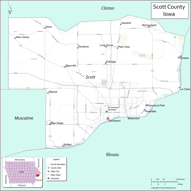
About Scott County Map, Iowa: The map showing the county boundary, county seat, major cities, highways, water bodies and neighbouring counties.
More Iowa Maps & Info
| Iowa Map | Iowa County Map | Iowa Cities Map |
| Iowa Zip codes | Where is Iowa | Airports in Iowa |
| Iowa Area Codes | Iowa Blank Map | Iowa River Map |
| Iowa Physical Map | Iowa Road Map | Where is Des Moines |
Map of Scott County, Iowa
Scott County is a county located in the U.S. state of Iowa. It's county seat is Davenport. As per 2020 census, the population of Scott County is 174170 people and population density is square miles. According to the United States Census Bureau, the county has a total area of 458 sq mi (1,186 km2). Scott County was established on -22654.
Scott County Facts
| Continent | North America |
| Country | United States |
| State | Iowa |
| County Seat | Davenport |
| Largest City/Town | Davenport |
| Established | December 21, 1837 |
| Total Area | 468 sq mi (1,212 sq km) |
| Land Area | 458 sq mi (1,186 sq km) |
| Water Area | 10 sq mi (26 sq km) |
| Population | 174,669 (Census 2020) |
| Population Density | 381.3 people per sq mi |
| Time Zone | Central Time Zone (CT) |
| Major Highways | Interstate 74, Interstate 80, Interstate 280, U.S. Highway 6, U.S. Highway 61, U.S. Highway 67, Iowa Highway 22, Iowa Highway 130 |
| Major Rivers | Mississippi River, Wapsipinicon River |
| Neighboring Counties | Clinton County, Cedar County, Muscatine County, Rock Island County (IL) |
| Famous For | Davenport, Quad Cities, Mississippi River, manufacturing, transportation, riverfront attractions |
| Top Attractions | Figge Art Museum, Mississippi Riverfront, Vander Veer Botanical Park, Putnam Museum, Freight House Farmers Market |
| Official Website | Official Website |
About Scott County, Iowa
Scott County is located in eastern Iowa along the Mississippi River and was established in 1837. The county seat and largest city is Davenport, which forms part of the Quad Cities metropolitan area. Scott County is the third-most populous county in Iowa and serves as a major center for manufacturing, transportation, healthcare, education, and river commerce. Its location along the Mississippi River has played an important role in the county's economic and cultural development. :contentReference[oaicite:0]{index=0}
Cities and Towns in Scott County, Iowa
| City Name | Type | Population (2020) | Pop. Density | Area | Incorporated |
|---|---|---|---|---|---|
| Durant | 1.15 sq mi (3 km2) | July 1, 1867 | |||
| Bettendorf | 39,102 | 21.22 sq mi (55 km2) | June 5, 1903 | ||
| Buffalo | 1,176 | 6.45 sq mi (16.7 km2) | July 15, 1875 | ||
| Davenport | 101,724 | 62.95 sq mi (163 km2) | February 5, 1881 | ||
| Dixon | 0.15 sq mi (0.39 km2) | May 12, 1909 | |||
| Donahue | 0.35 sq mi (0.91 km2) | May 1, 1909 | |||
| Eldridge | 9.48 sq mi (24.6 km2) | May 1, 1900 | |||
| Le Claire | 4.67 sq mi (12.1 km2) | January 13, 1855 | |||
| Long Grove | 1.02 sq mi (2.6 km2) | August 1, 1912 | |||
| Maysville | 0.27 sq mi (0.7 km2) | June 21, 1909 | |||
| McCausland | 0.54 sq mi (1.4 km2) | May 28, 1909 | |||
| New Liberty | 0.1 sq mi (0.26 km2) | June 26, 1909 | |||
| Panorama Park | 0.05 sq mi (0.13 km2) | July 7, 1953 | |||
| Princeton | 2.56 sq mi (6.6 km2) | January 29, 1857 | |||
| Riverdale | 1.84 sq mi (4.8 km2) | December 27, 1950 | |||
| Blue Grass | 1,666 | 2.89 sq mi (7.5 km2) | December 10, 1903 | ||
| Walcott | 3.47 sq mi (9 km2) | July 10, 1894 |
Best Golf Courses in Scott County, Iowa
| Golf Course | Location | Latitude & Longitude |
|---|---|---|
| TPC Deere Run | Silvis (near Davenport) | 41.4689°N, 90.3501°W |
| Crow Valley Golf Club | Davenport | 41.5712°N, 90.5316°W |
| Palmer Hills Golf Course | Bettendorf | 41.5531°N, 90.4722°W |
| Emeis Golf Course | Davenport | 41.5615°N, 90.6324°W |
| Red Hawk Golf Course | Davenport | 41.6132°N, 90.6039°W |
What are Major Roads and Highways in Scott County
Scott County serves as a major transportation hub in eastern Iowa.
- Interstate 74 - connects Davenport with Illinois and the Quad Cities region
- Interstate 80 - major transcontinental east-west interstate
- Interstate 280 - bypass route around the Quad Cities metropolitan area
- U.S. Highway 6 - important regional east-west route
- U.S. Highway 61 - major north-south corridor along eastern Iowa
- U.S. Highway 67 - Mississippi River route connecting river communities
- Iowa Highway 22 - serves southern Scott County communities
- Iowa Highway 130 - connects Davenport with Clinton County communities
Neighboring Counties of Scott County
- Clinton County (north)
- Cedar County (west)
- Muscatine County (southwest)
- Rock Island County, Illinois (east and south)
What are Top Attractions in Scott County, Iowa
Scott County offers a wide range of cultural, historical, and recreational attractions centered around the Mississippi River and the Quad Cities region.
| Main Sight Name | City | Famous For |
|---|---|---|
| Figge Art Museum | Davenport | Major regional art museum overlooking the Mississippi River |
| Putnam Museum and Science Center | Davenport | Science exhibits, history collections, and theater |
| Vander Veer Botanical Park | Davenport | Historic botanical gardens and conservatory |
| Freight House Farmers Market | Davenport | Popular riverfront market and local food destination |
| Mississippi Riverfront | Davenport | Scenic walking paths and river views |
| Isle Casino Hotel | Bettendorf | Gaming and entertainment venue |
| Buffalo Bill Museum | Le Claire | History of Buffalo Bill Cody and river heritage |
| Antique Archaeology | Le Claire | Popular shop featured on television |
| Scott County Park | Eldridge | Camping, trails, and outdoor recreation |
| Nahant Marsh | Davenport | Environmental education and wildlife habitat |
| Celebration Belle River Cruises | Davenport | Mississippi River sightseeing cruises |
| Quad City Botanical Areas | Countywide | Parks, trails, and nature recreation |
Distance from Scott County to Nearby Cities
The following distances are measured by road (driving) from Davenport.
- Davenport to Bettendorf (Scott County), Iowa - 5 mi (8 km)
- Davenport to Eldridge (Scott County), Iowa - 12 mi (19 km)
- Davenport to Le Claire (Scott County), Iowa - 15 mi (24 km)
- Davenport to Walcott (Scott County), Iowa - 15 mi (24 km)
- Davenport to Princeton (Scott County), Iowa - 20 mi (32 km)
- Davenport to Clinton (Clinton County), Iowa - 40 mi (64 km)
- Davenport to Tipton (Cedar County), Iowa - 31 mi (50 km)
- Davenport to Muscatine (Muscatine County), Iowa - 30 mi (48 km)
- Davenport to Iowa City (Johnson County), Iowa - 56 mi (90 km)
- Davenport to Cedar Rapids (Linn County), Iowa - 76 mi (122 km)
- Davenport to Dubuque (Dubuque County), Iowa - 92 mi (148 km)
- Davenport to Des Moines (Polk County), Iowa - 168 mi (270 km)
- Davenport to Chicago, Illinois - 170 mi (274 km)
- Davenport to Peoria, Illinois - 92 mi (148 km)
- Davenport to Minneapolis, Minnesota - 322 mi (518 km)
Nearest Airports
Nearest airport of Scott is Quad City International Airport (MLI / KMLI).
References
- QuickFacts - U.S. Census Bureau
- Official Scott County Website
- Scott County Profile
- United States Geological Survey (USGS)
- National Geodetic Survey
- Adair County Map
- Adams County Map
- Allamakee County Map
- Appanoose County Map
- Audubon County Map
- Benton County Map
- Black Hawk County Map
- Boone County Map
- Bremer County Map
- Buchanan County Map
- Buena Vista County Map
- Butler County Map
- Calhoun County Map
- Carroll County Map
- Cass County Map
- Cedar County Map
- Cerro Gordo County Map
- Cherokee County Map
- Chickasaw County Map
- Clarke County Map
- Clay County Map
- Clayton County Map
- Clinton County Map
- Crawford County Map
- Dallas County Map
- Davis County Map
- Decatur County Map
- Delaware County Map
- Des Moines County Map
- Dickinson County Map
- Dubuque County Map
- Emmet County Map
- Fayette County Map
- Floyd County Map
- Franklin County Map
- Fremont County Map
- Greene County Map
- Grundy County Map
- Guthrie County Map
- Hamilton County Map
- Hancock County Map
- Hardin County Map
- Harrison County Map
- Henry County Map
- Howard County Map
- Humboldt County Map
- Ida County Map
- Iowa County Map
- Jackson County Map
- Jasper County Map
- Jefferson County Map
- Johnson County Map
- Jones County Map
- Keokuk County Map
- Kossuth County Map
- Lee County Map
- Linn County Map
- Louisa County Map
- Lucas County Map
- Lyon County Map
- Madison County Map
- Mahaska County Map
- Marion County Map
- Marshall County Map
- Mills County Map
- Mitchell County Map
- Monona County Map
- Monroe County Map
- Montgomery County Map
- Muscatine County Map
- O'Brien County Map
- Osceola County Map
- Page County Map
- Palo Alto County Map
- Plymouth County Map
- Pocahontas County Map
- Polk County Map
- Pottawattamie County Map
- Poweshiek County Map
- Ringgold County Map
- Sac County Map
- Scott County Map
- Shelby County Map
- Sioux County Map
- Story County Map
- Tama County Map
- Taylor County Map
- Union County Map
- Van Buren County Map
- Wapello County Map
- Warren County Map
- Washington County Map
- Wayne County Map
- Webster County Map
- Winnebago County Map
- Winneshiek County Map
- Woodbury County Map
- Worth County Map
- Wright County Map
- Alabama Counties
- Alaska boroughs
- Arizona Counties
- Arkansas Counties
- California County Map
- Colorado Counties
- Connecticut Counties
- Delaware Counties
- Florida County Map
- Georgia County Map
- Hawaii Counties
- Idaho Counties
- Illinois Counties
- Indiana Counties
- Iowa Counties
- Kansas Counties
- Kentucky Counties
- Louisiana Counties
- Maine Counties
- Maryland Counties
- Massachusetts Counties
- Michigan County Map
- Minnesota Counties
- Mississippi Counties
- Missouri Counties
- Montana Counties
- Nebraska Counties
- Nevada Counties
- New York Counties
- New Hampshire Counties
- New Jersey Counties
- New Mexico Counties
- North Carolina Counties
- North Dakota Counties
- Ohio County Map
- Oklahoma Counties
- Oregon Counties
- Pennsylvania Counties
- Rhode Island Counties
- South Carolina Counties
- South Dakota Counties
- Map of Tennessee
- Texas County Map
- Utah Counties
- Vermont Counties
- Virginia Counties
- Washington Counties
- West Virginia Counties
- Wisconsin Counties
- Wyoming Counties