Written and Fact-checked by Whereig Editors | Last Updated On: June 10, 2026
Map of Cedar County - Cedar County is a county located in the U.S. state of Iowa. Cedar County Map showing cities, highways, important places and water bodies. Get Where is Cedar County located in the map, major cities in Cedar county, population, areas, and places of interest.
Cedar County Map, Iowa
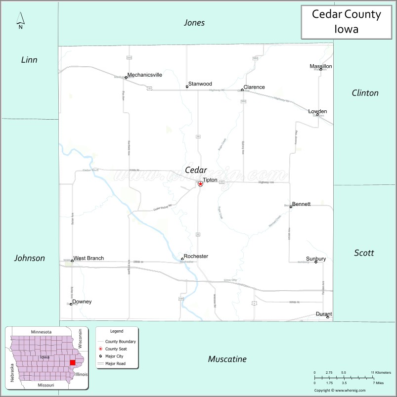
About Cedar County Map, Iowa: The map showing the county boundary, county seat, major cities, highways, water bodies and neighbouring counties.
More Iowa Maps & Info
| Iowa Map | Iowa County Map | Iowa Cities Map |
| Iowa Zip codes | Where is Iowa | Airports in Iowa |
| Iowa Area Codes | Iowa Blank Map | Iowa River Map |
| Iowa Physical Map | Iowa Road Map | Where is Des Moines |
Map of Cedar County, Iowa
Cedar County is a county located in the U.S. state of Iowa. It's county seat is Tipton. As per 2020 census, the population of Cedar County is 18410 people and population density is square miles. According to the United States Census Bureau, the county has a total area of 580 sq mi (1,502 km2). Cedar County was established on -22654.
Cedar County Facts
| Continent | North America |
| Country | United States |
| State | Iowa |
| County Seat | Tipton |
| Largest City/Town | Tipton |
| Established | December 21, 1837 |
| Total Area | 582 sq mi (1,507 sq km) |
| Land Area | 579 sq mi (1,500 sq km) |
| Water Area | 3 sq mi (8 sq km) |
| Population | 18,505 (Census 2020) |
| Population Density | 32.0 people per sq mi |
| Time Zone | Central Time Zone (CT) |
| Major Highways | Interstate 80, U.S. Highway 30, U.S. Highway 61, Iowa Highway 38, Iowa Highway 130 |
| Major Rivers | Cedar River, Wapsinonoc Creek |
| Neighboring Counties | Jones County, Clinton County, Scott County, Muscatine County, Johnson County, Linn County |
| Famous For | Tipton, Cedar River Valley, historic Lincoln Highway, agriculture, the Hardacre Theater |
| Top Attractions | Cedar Valley Park, Hardacre Theater, Rochester Cemetery, Hoover Nature Trail |
| Official Website | Official Website |
About Cedar County, Iowa
Cedar County is located in eastern Iowa and was established in 1837. The county seat is Tipton, which is also the largest city. The county lies between the Cedar River and the Iowa City-Quad Cities region, making it an important agricultural and transportation corridor. Cedar County is known for its historic communities, productive farmland, and strong connection to Iowa's early settlement history.
Cities and Towns in Cedar County, Iowa
| City/Town | Population (Census 2020) | Latitude & Longitude |
|---|---|---|
| Tipton (county seat) | 3,221 | 41.7692°N, 91.1271°W |
| West Branch (part) | 2,509 | 41.6714°N, 91.3460°W |
| Durant | 1,832 | 41.5998°N, 90.9107°W |
| Bennett | 405 | 41.7417°N, 90.9726°W |
| Clarence | 974 | 41.8887°N, 91.0578°W |
| Lowden | 789 | 41.8576°N, 90.9249°W |
| Mechanicsville | 1,020 | 41.9048°N, 91.2543°W |
| Stanwood | 684 | 41.8894°N, 91.1516°W |
| Springdale | 182 | 41.7519°N, 91.4413°W |
| Oasis (CDP) | 130 | 41.7010°N, 91.3119°W |
| Rochester (CDP) | 133 | 41.6776°N, 91.1607°W |
Best Golf Courses in Cedar County, Iowa
| Golf Course | Location | Latitude & Longitude |
|---|---|---|
| Cedar County Country Club | Tipton | 41.7678°N, 91.1424°W |
| Durant Golf Club | Durant | 41.5974°N, 90.9196°W |
| Tri-County Golf Club | Lowden | 41.8657°N, 90.9388°W |
| Blue Top Ridge Golf Course | Rural Cedar County (near Riverside area) | 41.6395°N, 91.5162°W |
What are Major Roads and Highways in Cedar County
Major highways connect the county to nearby regions and cities.
- Interstate 80 - major east-west interstate connecting the county with Iowa City, Davenport and Des Moines
- U.S. Highway 30 - crosses northern Cedar County and connects Mechanicsville, Stanwood and neighboring counties
- U.S. Highway 61 - north-south route linking the county with Muscatine, Clinton and the Quad Cities region
- Iowa Highway 38 - connects Tipton with Interstate 80 and Jones County
- Iowa Highway 130 - serves Durant and southern Cedar County communities
Neighboring Counties of Cedar County
- Jones County (north)
- Clinton County (northeast)
- Scott County (east)
- Muscatine County (south)
- Johnson County (west)
- Linn County (northwest)
What are Top Attractions in Cedar County, Iowa
The county offers a mix of natural and cultural attractions.
| Main Sight Name | City | Famous For |
|---|---|---|
| Hardacre Theater | Tipton | Historic restored movie theater and performing arts venue |
| Cedar County Historical Museum | Tipton | County history exhibits and pioneer collections |
| Cedar Valley Park | Tipton | Camping, hiking and outdoor recreation |
| Hoover Nature Trail | West Branch | Popular cycling and walking trail |
| Herbert Hoover National Historic Site | West Branch | Birthplace and childhood home of President Herbert Hoover |
| Rochester Cemetery | Rochester | Historic cemetery associated with early Iowa settlers |
| Stanwood Historical District | Stanwood | Historic architecture and small-town heritage |
| Lowden City Park | Lowden | Community recreation and events |
| Mechanicsville Historic Downtown | Mechanicsville | Historic business district and local culture |
| Wapsinonoc Creek Corridor | Tipton | Scenic waterway and wildlife habitat |
| Springdale Quaker Heritage Area | Springdale | Historic Quaker settlement and abolitionist history |
| Cedar River Recreation Area | Countywide | Fishing, boating and natural scenery |
Distance from Cedar County to Nearby Cities
The following distances are measured by road (driving).
- Tipton to Iowa City (Johnson County), Iowa - 28 mi (45 km)
- Tipton to Cedar Rapids (Linn County), Iowa - 33 mi (53 km)
- Tipton to Muscatine (Muscatine County), Iowa - 25 mi (40 km)
- Tipton to Davenport (Scott County), Iowa - 34 mi (55 km)
- Tipton to Clinton (Clinton County), Iowa - 39 mi (63 km)
- Tipton to Anamosa (Jones County), Iowa - 27 mi (43 km)
- Tipton to Maquoketa (Jackson County), Iowa - 40 mi (64 km)
- Tipton to Washington (Washington County), Iowa - 48 mi (77 km)
- Tipton to Mount Vernon (Linn County), Iowa - 20 mi (32 km)
- Tipton to Coralville (Johnson County), Iowa - 30 mi (48 km)
- Tipton to DeWitt (Clinton County), Iowa - 23 mi (37 km)
- Tipton to Dubuque (Dubuque County), Iowa - 77 mi (124 km)
- Tipton to Burlington (Des Moines County), Iowa - 86 mi (138 km)
- Tipton to Waterloo (Black Hawk County), Iowa - 79 mi (127 km)
- Tipton to Des Moines (Polk County), Iowa - 131 mi (211 km)
Nearest Airports
Nearest airport of Cedar is Eastern Iowa Airport (CID / KCID).
References
- QuickFacts - U.S. Census Bureau
- United States Census Bureau
- United States Geological Survey (USGS)
- National Geodetic Survey
- Official County Website
- Adair County Map
- Adams County Map
- Allamakee County Map
- Appanoose County Map
- Audubon County Map
- Benton County Map
- Black Hawk County Map
- Boone County Map
- Bremer County Map
- Buchanan County Map
- Buena Vista County Map
- Butler County Map
- Calhoun County Map
- Carroll County Map
- Cass County Map
- Cedar County Map
- Cerro Gordo County Map
- Cherokee County Map
- Chickasaw County Map
- Clarke County Map
- Clay County Map
- Clayton County Map
- Clinton County Map
- Crawford County Map
- Dallas County Map
- Davis County Map
- Decatur County Map
- Delaware County Map
- Des Moines County Map
- Dickinson County Map
- Dubuque County Map
- Emmet County Map
- Fayette County Map
- Floyd County Map
- Franklin County Map
- Fremont County Map
- Greene County Map
- Grundy County Map
- Guthrie County Map
- Hamilton County Map
- Hancock County Map
- Hardin County Map
- Harrison County Map
- Henry County Map
- Howard County Map
- Humboldt County Map
- Ida County Map
- Iowa County Map
- Jackson County Map
- Jasper County Map
- Jefferson County Map
- Johnson County Map
- Jones County Map
- Keokuk County Map
- Kossuth County Map
- Lee County Map
- Linn County Map
- Louisa County Map
- Lucas County Map
- Lyon County Map
- Madison County Map
- Mahaska County Map
- Marion County Map
- Marshall County Map
- Mills County Map
- Mitchell County Map
- Monona County Map
- Monroe County Map
- Montgomery County Map
- Muscatine County Map
- O'Brien County Map
- Osceola County Map
- Page County Map
- Palo Alto County Map
- Plymouth County Map
- Pocahontas County Map
- Polk County Map
- Pottawattamie County Map
- Poweshiek County Map
- Ringgold County Map
- Sac County Map
- Scott County Map
- Shelby County Map
- Sioux County Map
- Story County Map
- Tama County Map
- Taylor County Map
- Union County Map
- Van Buren County Map
- Wapello County Map
- Warren County Map
- Washington County Map
- Wayne County Map
- Webster County Map
- Winnebago County Map
- Winneshiek County Map
- Woodbury County Map
- Worth County Map
- Wright County Map
- Alabama Counties
- Alaska boroughs
- Arizona Counties
- Arkansas Counties
- California County Map
- Colorado Counties
- Connecticut Counties
- Delaware Counties
- Florida County Map
- Georgia County Map
- Hawaii Counties
- Idaho Counties
- Illinois Counties
- Indiana Counties
- Iowa Counties
- Kansas Counties
- Kentucky Counties
- Louisiana Counties
- Maine Counties
- Maryland Counties
- Massachusetts Counties
- Michigan County Map
- Minnesota Counties
- Mississippi Counties
- Missouri Counties
- Montana Counties
- Nebraska Counties
- Nevada Counties
- New York Counties
- New Hampshire Counties
- New Jersey Counties
- New Mexico Counties
- North Carolina Counties
- North Dakota Counties
- Ohio County Map
- Oklahoma Counties
- Oregon Counties
- Pennsylvania Counties
- Rhode Island Counties
- South Carolina Counties
- South Dakota Counties
- Map of Tennessee
- Texas County Map
- Utah Counties
- Vermont Counties
- Virginia Counties
- Washington Counties
- West Virginia Counties
- Wisconsin Counties
- Wyoming Counties