Written and Fact-checked by Whereig Editors | Last Updated On: June 10, 2026
Map of Carroll County - Carroll County is a county located in the U.S. state of Iowa. Carroll County Map showing cities, highways, important places and water bodies. Get Where is Carroll County located in the map, major cities in Carroll county, population, areas, and places of interest.
Carroll County Map, Iowa
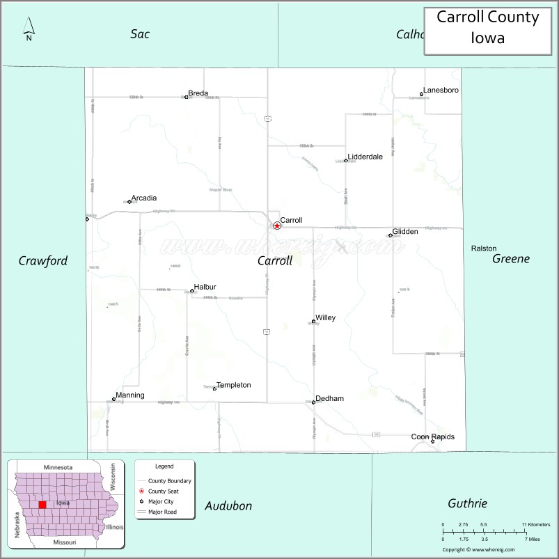
About Carroll County Map, Iowa: The map showing the county boundary, county seat, major cities, highways, water bodies and neighbouring counties.
More Iowa Maps & Info
| Iowa Map | Iowa County Map | Iowa Cities Map |
| Iowa Zip codes | Where is Iowa | Airports in Iowa |
| Iowa Area Codes | Iowa Blank Map | Iowa River Map |
| Iowa Physical Map | Iowa Road Map | Where is Des Moines |
Map of Carroll County, Iowa
Carroll County is a county located in the U.S. state of Iowa. It's county seat is Carroll. As per 2020 census, the population of Carroll County is 20692 people and population density is square miles. According to the United States Census Bureau, the county has a total area of 569 sq mi (1,474 km2). Carroll County was established on -17881.
Carroll County Facts
| Continent | North America |
| Country | United States |
| State | Iowa |
| County Seat | Carroll |
| Largest City/Town | Carroll |
| Established | January 15, 1851 |
| Total Area | 570 sq mi (1,476 sq km) |
| Land Area | 569 sq mi (1,474 sq km) |
| Water Area | 1 sq mi (2 sq km) |
| Population | 20,760 (Census 2020) |
| Population Density | 36.5 people per sq mi |
| Time Zone | Central Time Zone (CT) |
| Major Highways | U.S. Highway 30, U.S. Highway 71, Iowa Highway 141, Iowa Highway 210 |
| Major Rivers | Middle Raccoon River, North Raccoon River, Willow Creek |
| Neighboring Counties | Crawford County, Sac County, Calhoun County, Greene County, Guthrie County, Audubon County |
| Famous For | Agriculture, Swan Lake State Park, Catholic heritage, historic downtown Carroll |
| Top Attractions | Swan Lake State Park, Carroll Depot Museum, Graham Park, Kuemper Catholic heritage sites |
| Official Website | Official Website |
About Carroll County, Iowa
Carroll County is located in west-central Iowa and was established in 1851. The county seat is Carroll, which is also the largest city. The county is known for its productive farmland, strong agricultural economy, and vibrant communities. Carroll County has a rich German Catholic heritage and serves as a regional center for education, healthcare, and commerce in western Iowa.
Cities and Towns in Carroll County, Iowa
| City Name | Type | Population (2020) | Pop. Density | Area | Incorporated |
|---|---|---|---|---|---|
| Chadwick | Village | 481 | 1,546.6/sq mi (597.2/km2) | 0.311 sq mi (0.81 km2) | |
| Lanark | City | 1,504 | 1,341.7/sq mi (518.0/km2) | 1.121 sq mi (2.9 km2) | |
| Milledgeville | Village | 1,026 | 1,487.0/sq mi (574.1/km2) | 0.69 sq mi (1.79 km2) | |
| Mount Carroll | City | 1,479 | 738.4/sq mi (285.1/km2) | 2.003 sq mi (5.19 km2) | |
| Savanna | City | 2,783 | 1,063.8/sq mi (410.8/km2) | 2.616 sq mi (6.78 km2) | |
| Shannon | Village | 801 | 1,661.8/sq mi (641.6/km2) | 0.482 sq mi (1.25 km2) | |
| Thomson | Village | 1,610 | 725.6/sq mi (280.1/km2) | 2.219 sq mi (5.75 km2) | |
| Arcadia | 525 | 0.98 sq mi (2.5 km2) | November 3, 1881 | ||
| Breda | 500 | 0.74 sq mi (1.9 km2) | October 30, 1883 | ||
| Carroll | 5.69 sq mi (14.7 km2) | September 27, 1869 | |||
| Dedham | 0.58 sq mi (1.5 km2) | April 2, 1884 | |||
| Glidden | 1.11 sq mi (2.9 km2) | August 22, 1873 | |||
| Halbur | 0.19 sq mi (0.49 km2) | April 22, 1902 | |||
| Lanesboro | 0.74 sq mi (1.9 km2) | April 30, 1903 | |||
| Lidderdale | 2.42 sq mi (6.3 km2) | November 27, 1905 | |||
| Manning | 2.49 sq mi (6.4 km2) | February 17, 1882 | |||
| Templeton | 0.43 sq mi (1.1 km2) | September 28, 1883 | |||
| Willey | 0.25 sq mi (0.65 km2) | February 29, 1912 | |||
| Albany | 759 | 74 sq mi | 1766 | ||
| Bartlett | 3,200 | 74.9 sq mi | 1790 | ||
| Brookfield | 755 | 22.9 sq mi | 1794 | ||
| Chatham | 341 | 56.7 sq mi | 1767 | ||
| Conway | 9,822 | 69.4 sq mi | 1765 | ||
| Eaton | 405 | 24.3 sq mi | 1766 | ||
| Effingham | 1,691 | 38.4 sq mi | 1778 | ||
| Freedom | 1,689 | 35 sq mi | 1831 | ||
| Hart's Location | 68 | 18.5 sq mi | 1795 | ||
| Jackson | 1,028 | 66.9 sq mi | 1800 | ||
| Madison | 2,565 | 38.5 sq mi | 1852 | ||
| Moultonborough | 4,918 | 59.5 sq mi | 1777 | ||
| Ossipee | 4,372 | 70.8 sq mi | 1785 | ||
| Sandwich | 1,466 | 90.2 sq mi | 1763 | ||
| Tamworth | 2,812 | 59.7 sq mi | 1766 | ||
| Tuftonboro | 2,467 | 41 sq mi | 1795 | ||
| Wakefield | 5,201 | 39.5 sq mi | 1774 | ||
| Wolfeboro | 6,416 | 47.9 sq mi | 1770 | ||
| Ralston | 1.99 sq mi (5.2 km2) | October 31, 1903 | |||
| Coon Rapids | 1.78 sq mi (4.6 km2) | November 2, 1882 |
Best Golf Courses in Carroll County, Iowa
| Golf Course | Location | Latitude & Longitude |
|---|---|---|
| Carroll Country Club | Carroll | 42.0551°N, 94.8767°W |
| Carroll Municipal Golf Course | Carroll | 42.0725°N, 94.8475°W |
| Coon Rapids Country Club | Coon Rapids | 41.8726°N, 94.6865°W |
| Manning Manilla Golf Course | Manning | 41.9054°N, 95.0697°W |
| Breda Golf Club | Breda | 42.1793°N, 94.9872°W |
What are Major Roads and Highways in Carroll County
Major highways connect the county to nearby regions and cities.
- U.S. Highway 30 - major east-west route connecting Carroll with Denison, Boone and central Iowa
- U.S. Highway 71 - north-south corridor linking Carroll with Storm Lake, Audubon and surrounding counties
- Iowa Highway 141 - crosses the southern portion of the county and connects Coon Rapids with western Iowa communities
- Iowa Highway 210 - serves eastern Carroll County and connects with Greene and Guthrie counties
Neighboring Counties of Carroll County
- Sac County (north)
- Calhoun County (northeast)
- Greene County (east)
- Guthrie County (southeast)
- Audubon County (south)
- Crawford County (west)
What are Top Attractions in Carroll County, Iowa
The county offers a mix of natural and cultural attractions.
| Main Sight Name | City | Famous For |
|---|---|---|
| Swan Lake State Park | Carroll | Camping, fishing, boating and wildlife viewing |
| Carroll Depot Museum | Carroll | Historic railroad exhibits and local history |
| Graham Park | Carroll | Sports facilities, trails and family recreation |
| Kuemper Catholic Campus | Carroll | Historic educational and religious heritage |
| Merchants Park | Carroll | Historic baseball stadium and community events |
| Carroll County Historical Museum | Carroll | Regional history and cultural exhibits |
| Templeton Rye Heritage Area | Templeton | Historic connection to Templeton Rye whiskey |
| Manning Hausbarn Heritage Park | Manning | German heritage exhibits and historic buildings |
| Coon Rapids Historical Museum | Coon Rapids | Community history collections |
| Breda City Park | Breda | Outdoor recreation and local events |
| Arcadia Historical District | Arcadia | Historic architecture and cultural heritage |
| Middle Raccoon River Corridor | Countywide | Scenic landscapes, fishing and wildlife habitat |
Distance from Carroll County to Nearby Cities
The following distances are measured by road (driving).
- Carroll to Denison (Crawford County), Iowa - 31 mi (50 km)
- Carroll to Sac City (Sac County), Iowa - 24 mi (39 km)
- Carroll to Rockwell City (Calhoun County), Iowa - 36 mi (58 km)
- Carroll to Jefferson (Greene County), Iowa - 30 mi (48 km)
- Carroll to Guthrie Center (Guthrie County), Iowa - 34 mi (55 km)
- Carroll to Audubon (Audubon County), Iowa - 29 mi (47 km)
- Carroll to Storm Lake (Buena Vista County), Iowa - 39 mi (63 km)
- Carroll to Perry (Dallas County), Iowa - 48 mi (77 km)
- Carroll to Fort Dodge (Webster County), Iowa - 52 mi (84 km)
- Carroll to Ames (Story County), Iowa - 70 mi (113 km)
- Carroll to Council Bluffs (Pottawattamie County), Iowa - 82 mi (132 km)
- Carroll to Des Moines (Polk County), Iowa - 89 mi (143 km)
- Carroll to Sioux City (Woodbury County), Iowa - 92 mi (148 km)
- Carroll to Omaha, Nebraska - 95 mi (153 km)
- Carroll to Mason City (Cerro Gordo County), Iowa - 102 mi (164 km)
Nearest Airports
Nearest airport of Carroll is Des Moines International Airport (DSM / KDSM).
References
- QuickFacts - U.S. Census Bureau
- United States Census Bureau
- United States Geological Survey (USGS)
- National Geodetic Survey
- Official County Website
- Adair County Map
- Adams County Map
- Allamakee County Map
- Appanoose County Map
- Audubon County Map
- Benton County Map
- Black Hawk County Map
- Boone County Map
- Bremer County Map
- Buchanan County Map
- Buena Vista County Map
- Butler County Map
- Calhoun County Map
- Carroll County Map
- Cass County Map
- Cedar County Map
- Cerro Gordo County Map
- Cherokee County Map
- Chickasaw County Map
- Clarke County Map
- Clay County Map
- Clayton County Map
- Clinton County Map
- Crawford County Map
- Dallas County Map
- Davis County Map
- Decatur County Map
- Delaware County Map
- Des Moines County Map
- Dickinson County Map
- Dubuque County Map
- Emmet County Map
- Fayette County Map
- Floyd County Map
- Franklin County Map
- Fremont County Map
- Greene County Map
- Grundy County Map
- Guthrie County Map
- Hamilton County Map
- Hancock County Map
- Hardin County Map
- Harrison County Map
- Henry County Map
- Howard County Map
- Humboldt County Map
- Ida County Map
- Iowa County Map
- Jackson County Map
- Jasper County Map
- Jefferson County Map
- Johnson County Map
- Jones County Map
- Keokuk County Map
- Kossuth County Map
- Lee County Map
- Linn County Map
- Louisa County Map
- Lucas County Map
- Lyon County Map
- Madison County Map
- Mahaska County Map
- Marion County Map
- Marshall County Map
- Mills County Map
- Mitchell County Map
- Monona County Map
- Monroe County Map
- Montgomery County Map
- Muscatine County Map
- O'Brien County Map
- Osceola County Map
- Page County Map
- Palo Alto County Map
- Plymouth County Map
- Pocahontas County Map
- Polk County Map
- Pottawattamie County Map
- Poweshiek County Map
- Ringgold County Map
- Sac County Map
- Scott County Map
- Shelby County Map
- Sioux County Map
- Story County Map
- Tama County Map
- Taylor County Map
- Union County Map
- Van Buren County Map
- Wapello County Map
- Warren County Map
- Washington County Map
- Wayne County Map
- Webster County Map
- Winnebago County Map
- Winneshiek County Map
- Woodbury County Map
- Worth County Map
- Wright County Map
- Alabama Counties
- Alaska boroughs
- Arizona Counties
- Arkansas Counties
- California County Map
- Colorado Counties
- Connecticut Counties
- Delaware Counties
- Florida County Map
- Georgia County Map
- Hawaii Counties
- Idaho Counties
- Illinois Counties
- Indiana Counties
- Iowa Counties
- Kansas Counties
- Kentucky Counties
- Louisiana Counties
- Maine Counties
- Maryland Counties
- Massachusetts Counties
- Michigan County Map
- Minnesota Counties
- Mississippi Counties
- Missouri Counties
- Montana Counties
- Nebraska Counties
- Nevada Counties
- New York Counties
- New Hampshire Counties
- New Jersey Counties
- New Mexico Counties
- North Carolina Counties
- North Dakota Counties
- Ohio County Map
- Oklahoma Counties
- Oregon Counties
- Pennsylvania Counties
- Rhode Island Counties
- South Carolina Counties
- South Dakota Counties
- Map of Tennessee
- Texas County Map
- Utah Counties
- Vermont Counties
- Virginia Counties
- Washington Counties
- West Virginia Counties
- Wisconsin Counties
- Wyoming Counties