Written and Fact-checked by Whereig Editors | Last Updated On: June 10, 2026
Map of Des Moines County - Des Moines County is a county located in the U.S. state of Iowa. Des Moines County Map showing cities, highways, important places and water bodies. Get Where is Des Moines County located in the map, major cities in Des Moines county, population, areas, and places of interest.
Des Moines County Map, Iowa
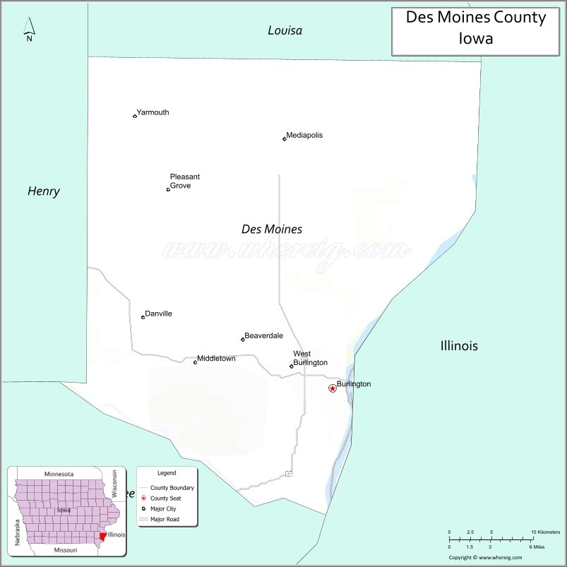
About Des Moines County Map, Iowa: The map showing the county boundary, county seat, major cities, highways, water bodies and neighbouring counties.
More Iowa Maps & Info
| Iowa Map | Iowa County Map | Iowa Cities Map |
| Iowa Zip codes | Where is Iowa | Airports in Iowa |
| Iowa Area Codes | Iowa Blank Map | Iowa River Map |
| Iowa Physical Map | Iowa Road Map | Where is Des Moines |
Map of Des Moines County, Iowa
Des Moines County is a county located in the U.S. state of Iowa. It's county seat is Burlington. As per 2020 census, the population of Des Moines County is 38491 people and population density is square miles. According to the United States Census Bureau, the county has a total area of 416 sq mi (1,077 km2). Des Moines County was established on -23856.
Des Moines County Facts
| Continent | North America |
| Country | United States |
| State | Iowa |
| County Seat | Burlington |
| Largest City/Town | Burlington |
| Established | September 6, 1834 |
| Total Area | 416 sq mi (1,077 sq km) |
| Land Area | 408 sq mi (1,057 sq km) |
| Water Area | 8 sq mi (20 sq km) |
| Population | 38,910 (Census 2020) |
| Population Density | 95.4 people per sq mi |
| Time Zone | Central Time Zone (CT) |
| Major Highways | U.S. Highway 34, U.S. Highway 61, Iowa Highway 99, Iowa Highway 406 |
| Major Rivers | Mississippi River, Skunk River |
| Neighboring Counties | Louisa County, Henry County, Lee County, Henderson County (IL), Hancock County (IL) |
| Famous For | Burlington riverfront, Snake Alley, Mississippi River history, manufacturing heritage |
| Top Attractions | Snake Alley, Port of Burlington Welcome Center, Crapo Park, FunCity Resort |
| Official Website | Official Website |
About Des Moines County, Iowa
Des Moines County is located in southeastern Iowa along the Mississippi River and was established in 1834, making it one of Iowa's oldest counties. The county seat is Burlington, which is also the largest city. The county played an important role in the early settlement of Iowa Territory and remains a regional center for industry, healthcare, transportation, and tourism. Its riverfront setting provides scenic views, historic landmarks, and recreational opportunities.
Cities and Towns in Des Moines County, Iowa
| City/Town | Population (Census 2020) | Latitude & Longitude |
|---|---|---|
| Burlington (county seat) | 23,982 | 40.8075°N, 91.1129°W |
| Mediapolis | 1,688 | 41.0081°N, 91.1643°W |
| West Burlington | 2,968 | 40.8256°N, 91.1588°W |
| Danville | 934 | 40.8598°N, 91.3149°W |
| Middletown | 363 | 40.8267°N, 91.2602°W |
| Sperry | 124 | 40.9689°N, 91.1538°W |
| Augusta (part) | 427 | 40.7519°N, 91.2749°W |
| Yarmouth (part) | 78 | 40.9147°N, 91.3474°W |
Best Golf Courses in Des Moines County, Iowa
| Golf Course | Location | Latitude & Longitude |
|---|---|---|
| Spirit Hollow Golf Course | Burlington | 40.8638°N, 91.1748°W |
| Burlington Golf Club | Burlington | 40.8324°N, 91.1185°W |
| Flint Hills Municipal Golf Course | Burlington | 40.8361°N, 91.1264°W |
| Hidden Hills Golf Course | Middletown | 40.8184°N, 91.2435°W |
What are Major Roads and Highways in Des Moines County
Major highways connect the county to nearby regions and cities.
- U.S. Highway 34 - major east-west route crossing Burlington and connecting southeastern Iowa with Illinois
- U.S. Highway 61 - north-south corridor linking Burlington with Muscatine, Davenport, and Missouri
- Iowa Highway 99 - serves western portions of the county and connects rural communities
- Iowa Highway 406 - connector route providing access to Burlington and nearby transportation corridors
Neighboring Counties of Des Moines County
- Louisa County (north)
- Henry County (west)
- Lee County (south)
- Henderson County, Illinois (east)
- Hancock County, Illinois (southeast)
What are Top Attractions in Des Moines County, Iowa
The county offers a mix of natural and cultural attractions.
| Main Sight Name | City | Famous For |
|---|---|---|
| Snake Alley | Burlington | Historic winding brick street often called the crookedest street in the world |
| Crapo Park | Burlington | Scenic Mississippi River overlooks and gardens |
| Port of Burlington Welcome Center | Burlington | Riverfront visitor center and Mississippi River exhibits |
| FunCity Resort | West Burlington | Family entertainment, water park, and gaming facilities |
| Des Moines County Heritage Center Museum | Burlington | Regional history exhibits and artifacts |
| Capitol Theater | Burlington | Historic performing arts venue |
| Mosquito Park | Burlington | Blufftop Mississippi River views |
| Dankwardt Memorial Park | Burlington | Sports facilities, trails, and outdoor recreation |
| Hawkeye Creek Trail | Burlington | Walking and cycling opportunities |
| Big Hollow Recreation Area | Sperry | Fishing, boating, camping, and hiking |
| Mediapolis Historical Museum | Mediapolis | Local history and community heritage |
| Mississippi River Scenic Corridor | Countywide | Riverfront scenery, wildlife viewing, and recreation |
Distance from Des Moines County to Nearby Cities
The following distances are measured by road (driving).
- Burlington to West Burlington (Des Moines County), Iowa - 3 mi (5 km)
- Burlington to Mediapolis (Des Moines County), Iowa - 12 mi (19 km)
- Burlington to Mount Pleasant (Henry County), Iowa - 27 mi (43 km)
- Burlington to Wapello (Louisa County), Iowa - 28 mi (45 km)
- Burlington to Fort Madison (Lee County), Iowa - 21 mi (34 km)
- Burlington to Keokuk (Lee County), Iowa - 42 mi (68 km)
- Burlington to Monmouth (Warren County), Illinois - 30 mi (48 km)
- Burlington to Macomb (McDonough County), Illinois - 42 mi (68 km)
- Burlington to Iowa City (Johnson County), Iowa - 78 mi (126 km)
- Burlington to Quincy, Illinois - 67 mi (108 km)
- Burlington to Cedar Rapids (Linn County), Iowa - 88 mi (142 km)
- Burlington to Davenport (Scott County), Iowa - 79 mi (127 km)
- Burlington to Peoria, Illinois - 96 mi (154 km)
- Burlington to Springfield, Illinois - 111 mi (179 km)
- Burlington to Des Moines (Polk County), Iowa - 170 mi (274 km)
Nearest Airports
Nearest airport of Des Moines are Des Moines International Airport, Southeast Iowa Regional Airport (IATA code BRL).
References
- QuickFacts - U.S. Census Bureau
- United States Census Bureau
- United States Geological Survey (USGS)
- National Geodetic Survey
- Official County Website
- Adair County Map
- Adams County Map
- Allamakee County Map
- Appanoose County Map
- Audubon County Map
- Benton County Map
- Black Hawk County Map
- Boone County Map
- Bremer County Map
- Buchanan County Map
- Buena Vista County Map
- Butler County Map
- Calhoun County Map
- Carroll County Map
- Cass County Map
- Cedar County Map
- Cerro Gordo County Map
- Cherokee County Map
- Chickasaw County Map
- Clarke County Map
- Clay County Map
- Clayton County Map
- Clinton County Map
- Crawford County Map
- Dallas County Map
- Davis County Map
- Decatur County Map
- Delaware County Map
- Des Moines County Map
- Dickinson County Map
- Dubuque County Map
- Emmet County Map
- Fayette County Map
- Floyd County Map
- Franklin County Map
- Fremont County Map
- Greene County Map
- Grundy County Map
- Guthrie County Map
- Hamilton County Map
- Hancock County Map
- Hardin County Map
- Harrison County Map
- Henry County Map
- Howard County Map
- Humboldt County Map
- Ida County Map
- Iowa County Map
- Jackson County Map
- Jasper County Map
- Jefferson County Map
- Johnson County Map
- Jones County Map
- Keokuk County Map
- Kossuth County Map
- Lee County Map
- Linn County Map
- Louisa County Map
- Lucas County Map
- Lyon County Map
- Madison County Map
- Mahaska County Map
- Marion County Map
- Marshall County Map
- Mills County Map
- Mitchell County Map
- Monona County Map
- Monroe County Map
- Montgomery County Map
- Muscatine County Map
- O'Brien County Map
- Osceola County Map
- Page County Map
- Palo Alto County Map
- Plymouth County Map
- Pocahontas County Map
- Polk County Map
- Pottawattamie County Map
- Poweshiek County Map
- Ringgold County Map
- Sac County Map
- Scott County Map
- Shelby County Map
- Sioux County Map
- Story County Map
- Tama County Map
- Taylor County Map
- Union County Map
- Van Buren County Map
- Wapello County Map
- Warren County Map
- Washington County Map
- Wayne County Map
- Webster County Map
- Winnebago County Map
- Winneshiek County Map
- Woodbury County Map
- Worth County Map
- Wright County Map
- Alabama Counties
- Alaska boroughs
- Arizona Counties
- Arkansas Counties
- California County Map
- Colorado Counties
- Connecticut Counties
- Delaware Counties
- Florida County Map
- Georgia County Map
- Hawaii Counties
- Idaho Counties
- Illinois Counties
- Indiana Counties
- Iowa Counties
- Kansas Counties
- Kentucky Counties
- Louisiana Counties
- Maine Counties
- Maryland Counties
- Massachusetts Counties
- Michigan County Map
- Minnesota Counties
- Mississippi Counties
- Missouri Counties
- Montana Counties
- Nebraska Counties
- Nevada Counties
- New York Counties
- New Hampshire Counties
- New Jersey Counties
- New Mexico Counties
- North Carolina Counties
- North Dakota Counties
- Ohio County Map
- Oklahoma Counties
- Oregon Counties
- Pennsylvania Counties
- Rhode Island Counties
- South Carolina Counties
- South Dakota Counties
- Map of Tennessee
- Texas County Map
- Utah Counties
- Vermont Counties
- Virginia Counties
- Washington Counties
- West Virginia Counties
- Wisconsin Counties
- Wyoming Counties