Written and Fact-checked by Whereig Editors | Last Updated On: June 10, 2026
Map of Greene County - Greene County is a county located in the U.S. state of Iowa. Greene County Map showing cities, highways, important places and water bodies. Get Where is Greene County located in the map, major cities in Greene county, population, areas, and places of interest.
Greene County Map, Iowa
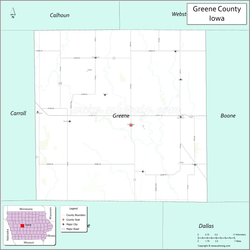
About Greene County Map, Iowa: The map showing the county boundary, county seat, major cities, highways, water bodies and neighbouring counties.
More Iowa Maps & Info
| Iowa Map | Iowa County Map | Iowa Cities Map |
| Iowa Zip codes | Where is Iowa | Airports in Iowa |
| Iowa Area Codes | Iowa Blank Map | Iowa River Map |
| Iowa Physical Map | Iowa Road Map | Where is Des Moines |
Map of Greene County, Iowa
Greene County is a county located in the U.S. state of Iowa. It's county seat is Jefferson. As per 2020 census, the population of Greene County is 8717 people and population density is square miles. According to the United States Census Bureau, the county has a total area of 568 sq mi (1,471 km2). Greene County was established on -17881.
Greene County Facts
| Continent | North America |
| Country | United States |
| State | Iowa |
| County Seat | Jefferson |
| Largest City/Town | Jefferson |
| Established | January 15, 1851 |
| Total Area | 571 sq mi (1,479 sq km) |
| Land Area | 570 sq mi (1,476 sq km) |
| Water Area | 1 sq mi (3 sq km) |
| Population | 8,999 (Census 2020) |
| Population Density | 15.8 people per sq mi |
| Time Zone | Central Time Zone (CT) |
| Major Highways | U.S. Highway 30, Iowa Highway 4, Iowa Highway 25, Iowa Highway 144 |
| Major Rivers | Raccoon River, North Raccoon River |
| Neighboring Counties | Calhoun County, Carroll County, Guthrie County, Boone County, Webster County, Dallas County |
| Famous For | Jefferson, Mahanay Bell Tower, historic Lincoln Highway corridor, agriculture |
| Top Attractions | Mahanay Bell Tower, Greene County Historical Museum, Spring Lake Park, Lincoln Highway Heritage Byway |
| Official Website | Official Website |
About Greene County, Iowa
Greene County is located in west-central Iowa and was established in 1851. The county seat and largest city is Jefferson. The county is known for its rich agricultural heritage, historic communities, and the iconic Mahanay Bell Tower that dominates the Jefferson skyline. Greene County also lies along the historic Lincoln Highway, one of America's earliest transcontinental roads.
Cities and Towns in Greene County, Iowa
| City/Town | Population (Census 2020) | Latitude & Longitude |
|---|---|---|
| Jefferson (county seat) | 4,182 | 42.0153°N, 94.3775°W |
| Grand Junction | 756 | 42.0328°N, 94.2341°W |
| Scranton | 549 | 42.0214°N, 94.5478°W |
| Rippey | 268 | 41.9336°N, 94.2022°W |
| Paton | 225 | 42.1689°N, 94.2491°W |
| Dana | 71 | 42.1069°N, 94.2452°W |
| Churdan | 365 | 42.1625°N, 94.4844°W |
Best Golf Courses in Greene County, Iowa
| Golf Course | Location | Latitude & Longitude |
|---|---|---|
| Jefferson Community Golf Course | Jefferson | 42.0179°N, 94.3897°W |
| Coon Rapids Golf Association Course | Jefferson Area | 42.0364°N, 94.4125°W |
| Spring Lake Country Club | Jefferson | 42.0068°N, 94.3654°W |
What are Major Roads and Highways in Greene County
Major highways connect the county to nearby regions and cities.
- U.S. Highway 30 - major east-west route crossing Jefferson and connecting the county with Ames, Carroll, and regional destinations
- Iowa Highway 4 - north-south corridor serving Jefferson and connecting neighboring counties
- Iowa Highway 25 - provides access to communities in the eastern and southern portions of the county
- Iowa Highway 144 - links rural communities with U.S. Highway 30 and surrounding regions
Neighboring Counties of Greene County
- Calhoun County (north)
- Carroll County (west)
- Guthrie County (south)
- Dallas County (southeast)
- Boone County (east)
- Webster County (northeast)
What are Top Attractions in Greene County, Iowa
The county offers a mix of natural and cultural attractions.
| Main Sight Name | City | Famous For |
|---|---|---|
| Mahanay Bell Tower | Jefferson | 168-foot landmark tower with panoramic views |
| Greene County Historical Museum | Jefferson | County history exhibits and artifacts |
| Spring Lake Park | Jefferson | Camping, fishing, trails, and outdoor recreation |
| Lincoln Highway Heritage Byway | Countywide | Historic transcontinental highway route |
| Thomas Jefferson Gardens | Jefferson | Beautiful themed gardens and walking paths |
| Jefferson Community Center | Jefferson | Community events and recreation |
| Paton House Museum | Paton | Historic local heritage exhibits |
| Raccoon River Valley | Countywide | Scenic landscapes and wildlife viewing |
| Grand Junction Depot Museum | Grand Junction | Railroad history and local heritage |
| Scranton City Park | Scranton | Family recreation and community events |
| Churdan Heritage Center | Churdan | Small-town history and cultural exhibits |
| Spring Lake Marina Area | Jefferson | Boating and lakeside recreation |
Distance from Greene County to Nearby Cities
The following distances are measured by road (driving).
- Jefferson to Carroll (Carroll County), Iowa - 16 mi (26 km)
- Jefferson to Boone (Boone County), Iowa - 29 mi (47 km)
- Jefferson to Guthrie Center (Guthrie County), Iowa - 27 mi (43 km)
- Jefferson to Fort Dodge (Webster County), Iowa - 43 mi (69 km)
- Jefferson to Rockwell City (Calhoun County), Iowa - 28 mi (45 km)
- Jefferson to Perry (Dallas County), Iowa - 30 mi (48 km)
- Jefferson to Ames (Story County), Iowa - 42 mi (68 km)
- Jefferson to Atlantic (Cass County), Iowa - 53 mi (85 km)
- Jefferson to Storm Lake (Buena Vista County), Iowa - 54 mi (87 km)
- Jefferson to Council Bluffs (Pottawattamie County), Iowa - 88 mi (142 km)
- Jefferson to Des Moines (Polk County), Iowa - 58 mi (93 km)
- Jefferson to Sioux City (Woodbury County), Iowa - 101 mi (163 km)
- Jefferson to Waterloo (Black Hawk County), Iowa - 109 mi (175 km)
- Jefferson to Omaha, Nebraska - 96 mi (154 km)
- Jefferson to Cedar Rapids (Linn County), Iowa - 128 mi (206 km)
Nearest Airports
Nearest airport of Greene is Waterloo Regional Airport.
References
- QuickFacts - U.S. Census Bureau
- United States Census Bureau
- United States Geological Survey (USGS)
- National Geodetic Survey
- Official County Website
- Adair County Map
- Adams County Map
- Allamakee County Map
- Appanoose County Map
- Audubon County Map
- Benton County Map
- Black Hawk County Map
- Boone County Map
- Bremer County Map
- Buchanan County Map
- Buena Vista County Map
- Butler County Map
- Calhoun County Map
- Carroll County Map
- Cass County Map
- Cedar County Map
- Cerro Gordo County Map
- Cherokee County Map
- Chickasaw County Map
- Clarke County Map
- Clay County Map
- Clayton County Map
- Clinton County Map
- Crawford County Map
- Dallas County Map
- Davis County Map
- Decatur County Map
- Delaware County Map
- Des Moines County Map
- Dickinson County Map
- Dubuque County Map
- Emmet County Map
- Fayette County Map
- Floyd County Map
- Franklin County Map
- Fremont County Map
- Greene County Map
- Grundy County Map
- Guthrie County Map
- Hamilton County Map
- Hancock County Map
- Hardin County Map
- Harrison County Map
- Henry County Map
- Howard County Map
- Humboldt County Map
- Ida County Map
- Iowa County Map
- Jackson County Map
- Jasper County Map
- Jefferson County Map
- Johnson County Map
- Jones County Map
- Keokuk County Map
- Kossuth County Map
- Lee County Map
- Linn County Map
- Louisa County Map
- Lucas County Map
- Lyon County Map
- Madison County Map
- Mahaska County Map
- Marion County Map
- Marshall County Map
- Mills County Map
- Mitchell County Map
- Monona County Map
- Monroe County Map
- Montgomery County Map
- Muscatine County Map
- O'Brien County Map
- Osceola County Map
- Page County Map
- Palo Alto County Map
- Plymouth County Map
- Pocahontas County Map
- Polk County Map
- Pottawattamie County Map
- Poweshiek County Map
- Ringgold County Map
- Sac County Map
- Scott County Map
- Shelby County Map
- Sioux County Map
- Story County Map
- Tama County Map
- Taylor County Map
- Union County Map
- Van Buren County Map
- Wapello County Map
- Warren County Map
- Washington County Map
- Wayne County Map
- Webster County Map
- Winnebago County Map
- Winneshiek County Map
- Woodbury County Map
- Worth County Map
- Wright County Map
- Alabama Counties
- Alaska boroughs
- Arizona Counties
- Arkansas Counties
- California County Map
- Colorado Counties
- Connecticut Counties
- Delaware Counties
- Florida County Map
- Georgia County Map
- Hawaii Counties
- Idaho Counties
- Illinois Counties
- Indiana Counties
- Iowa Counties
- Kansas Counties
- Kentucky Counties
- Louisiana Counties
- Maine Counties
- Maryland Counties
- Massachusetts Counties
- Michigan County Map
- Minnesota Counties
- Mississippi Counties
- Missouri Counties
- Montana Counties
- Nebraska Counties
- Nevada Counties
- New York Counties
- New Hampshire Counties
- New Jersey Counties
- New Mexico Counties
- North Carolina Counties
- North Dakota Counties
- Ohio County Map
- Oklahoma Counties
- Oregon Counties
- Pennsylvania Counties
- Rhode Island Counties
- South Carolina Counties
- South Dakota Counties
- Map of Tennessee
- Texas County Map
- Utah Counties
- Vermont Counties
- Virginia Counties
- Washington Counties
- West Virginia Counties
- Wisconsin Counties
- Wyoming Counties