Written and Fact-checked by Whereig Editors | Last Updated On: June 10, 2026
Map of Muscatine County - Muscatine County is a county located in the U.S. state of Iowa. Muscatine County Map showing cities, highways, important places and water bodies. Get Where is Muscatine County located in the map, major cities in Muscatine county, population, areas, and places of interest.
Muscatine County Map, Iowa
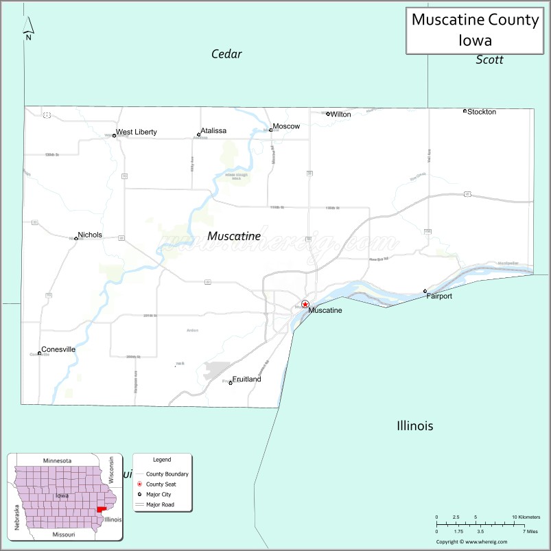
About Muscatine County Map, Iowa: The map showing the county boundary, county seat, major cities, highways, water bodies and neighbouring counties.
More Iowa Maps & Info
| Iowa Map | Iowa County Map | Iowa Cities Map |
| Iowa Zip codes | Where is Iowa | Airports in Iowa |
| Iowa Area Codes | Iowa Blank Map | Iowa River Map |
| Iowa Physical Map | Iowa Road Map | Where is Des Moines |
Map of Muscatine County, Iowa
Muscatine County is a county located in the U.S. state of Iowa. It's county seat is Muscatine. As per 2020 census, the population of Muscatine County is 42688 people and population density is square miles. According to the United States Census Bureau, the county has a total area of 439 sq mi (1,137 km2). Muscatine County was established on -23033.
Muscatine County Facts
| Continent | North America |
| Country | United States |
| State | Iowa |
| County Seat | Muscatine |
| Largest City/Town | Muscatine |
| Established | December 7, 1836 |
| Total Area | 449 sq mi (1,163 sq km) |
| Land Area | 437 sq mi (1,132 sq km) |
| Water Area | 12 sq mi (31 sq km) |
| Population | 42,745 (Census 2020) |
| Population Density | 97.8 people per sq mi |
| Time Zone | Central Time Zone (CT) |
| Major Highways | Interstate 80, U.S. Highway 61, U.S. Highway 6, Iowa Highway 22, Iowa Highway 38 |
| Major Rivers | Mississippi River, Cedar River |
| Neighboring Counties | Cedar County, Johnson County, Louisa County, Scott County, Rock Island County (IL) |
| Famous For | Muscatine, Pearl Button Industry, Mississippi River, agricultural production |
| Top Attractions | Mississippi Riverfront, Muscatine History and Industry Center, Wildcat Den State Park, Pine Creek Grist Mill |
| Official Website | Official Website |
About Muscatine County, Iowa
Muscatine County is located in eastern Iowa along the Mississippi River and was established in 1836. The county seat and largest city is Muscatine. Historically known as the "Pearl Button Capital of the World," the county developed around river commerce, manufacturing, and agriculture. Today, Muscatine County combines a strong industrial economy with scenic riverfront landscapes and recreational opportunities.
Cities and Towns in Muscatine County, Iowa
| City/Town | Population (Census 2020) | Latitude & Longitude |
|---|---|---|
| Muscatine (county seat) | 23,797 | 41.4245°N, 91.0432°W |
| West Liberty | 3,858 | 41.5706°N, 91.2632°W |
| Wilton | 2,904 | 41.5884°N, 91.0154°W |
| Nichols | 374 | 41.4864°N, 91.3082°W |
| Fruitland | 1,027 | 41.3458°N, 91.1235°W |
| Atalissa | 311 | 41.5667°N, 91.1690°W |
| Conesville | 308 | 41.4028°N, 91.3468°W |
| Stockton | 682 | 41.5900°N, 91.0010°W |
| Moscow | 267 | 41.5733°N, 91.0735°W |
| Blue Grass (partly) | 1,282 | 41.5092°N, 90.7657°W |
Best Golf Courses in Muscatine County, Iowa
| Golf Course | Location | Latitude & Longitude |
|---|---|---|
| Muscatine Municipal Golf Course | Muscatine | 41.4406°N, 91.0607°W |
| Geneva Golf & Country Club | Muscatine | 41.4514°N, 91.0843°W |
| West Liberty Country Club | West Liberty | 41.5746°N, 91.2768°W |
| Wilton Candy Kitchen Golf Area | Wilton | 41.5901°N, 91.0192°W |
What are Major Roads and Highways in Muscatine County
Major highways connect the county to nearby regions and cities.
- Interstate 80 - major east-west interstate crossing the northern part of the county
- U.S. Highway 61 - principal north-south route connecting Muscatine with Davenport and Burlington
- U.S. Highway 6 - historic east-west route serving Wilton and West Liberty
- Iowa Highway 22 - scenic route along the Mississippi River corridor
- Iowa Highway 38 - connects Muscatine with Tipton and Cedar County
Neighboring Counties of Muscatine County
- Cedar County (north)
- Johnson County (northwest)
- Louisa County (southwest)
- Scott County (east)
- Rock Island County, Illinois (east across the Mississippi River)
What are Top Attractions in Muscatine County, Iowa
The county offers a mix of natural and cultural attractions.
| Main Sight Name | City | Famous For |
|---|---|---|
| Mississippi Riverfront | Muscatine | Scenic river views, trails, and recreation |
| Muscatine History and Industry Center | Muscatine | Pearl button industry and local history exhibits |
| Wildcat Den State Park | Near Muscatine | Hiking, rock formations, and natural beauty |
| Pine Creek Grist Mill | Wildcat Den State Park | Historic 1848 grist mill |
| Weed Park | Muscatine | Gardens, zoo, and recreation facilities |
| Discovery Park | Muscatine | Family recreation and playgrounds |
| Muscatine Art Center | Muscatine | Art collections and historic mansion |
| Pearl City Station | Muscatine | Historic railroad heritage site |
| West Liberty Heritage Museum | West Liberty | Local cultural history exhibits |
| Wilton Candy Kitchen | Wilton | Historic soda fountain and confectionery |
| Cedar River Access Areas | Countywide | Fishing and boating opportunities |
| Muscatine Arboretum | Muscatine | Nature trails and native plant collections |
Distance from Muscatine County to Nearby Cities
The following distances are measured by road (driving).
- Muscatine to West Liberty (Muscatine County), Iowa - 14 mi (23 km)
- Muscatine to Wilton (Muscatine County), Iowa - 11 mi (18 km)
- Muscatine to Fruitland (Muscatine County), Iowa - 4 mi (6 km)
- Muscatine to Tipton (Cedar County), Iowa - 21 mi (34 km)
- Muscatine to Iowa City (Johnson County), Iowa - 33 mi (53 km)
- Muscatine to Wapello (Louisa County), Iowa - 28 mi (45 km)
- Muscatine to Davenport (Scott County), Iowa - 30 mi (48 km)
- Muscatine to Moline, Illinois - 33 mi (53 km)
- Muscatine to Burlington (Des Moines County), Iowa - 69 mi (111 km)
- Muscatine to Cedar Rapids (Linn County), Iowa - 63 mi (101 km)
- Muscatine to Dubuque (Dubuque County), Iowa - 103 mi (166 km)
- Muscatine to Des Moines (Polk County), Iowa - 166 mi (267 km)
- Muscatine to Chicago, Illinois - 176 mi (283 km)
- Muscatine to Springfield, Illinois - 191 mi (307 km)
- Muscatine to St. Louis, Missouri - 247 mi (398 km)
Nearest Airports
Nearest airport of Muscatine is Quad City International Airport (MLI / KMLI).
References
- QuickFacts - U.S. Census Bureau
- United States Census Bureau
- United States Geological Survey (USGS)
- National Geodetic Survey
- Official Muscatine County Website
- Adair County Map
- Adams County Map
- Allamakee County Map
- Appanoose County Map
- Audubon County Map
- Benton County Map
- Black Hawk County Map
- Boone County Map
- Bremer County Map
- Buchanan County Map
- Buena Vista County Map
- Butler County Map
- Calhoun County Map
- Carroll County Map
- Cass County Map
- Cedar County Map
- Cerro Gordo County Map
- Cherokee County Map
- Chickasaw County Map
- Clarke County Map
- Clay County Map
- Clayton County Map
- Clinton County Map
- Crawford County Map
- Dallas County Map
- Davis County Map
- Decatur County Map
- Delaware County Map
- Des Moines County Map
- Dickinson County Map
- Dubuque County Map
- Emmet County Map
- Fayette County Map
- Floyd County Map
- Franklin County Map
- Fremont County Map
- Greene County Map
- Grundy County Map
- Guthrie County Map
- Hamilton County Map
- Hancock County Map
- Hardin County Map
- Harrison County Map
- Henry County Map
- Howard County Map
- Humboldt County Map
- Ida County Map
- Iowa County Map
- Jackson County Map
- Jasper County Map
- Jefferson County Map
- Johnson County Map
- Jones County Map
- Keokuk County Map
- Kossuth County Map
- Lee County Map
- Linn County Map
- Louisa County Map
- Lucas County Map
- Lyon County Map
- Madison County Map
- Mahaska County Map
- Marion County Map
- Marshall County Map
- Mills County Map
- Mitchell County Map
- Monona County Map
- Monroe County Map
- Montgomery County Map
- Muscatine County Map
- O'Brien County Map
- Osceola County Map
- Page County Map
- Palo Alto County Map
- Plymouth County Map
- Pocahontas County Map
- Polk County Map
- Pottawattamie County Map
- Poweshiek County Map
- Ringgold County Map
- Sac County Map
- Scott County Map
- Shelby County Map
- Sioux County Map
- Story County Map
- Tama County Map
- Taylor County Map
- Union County Map
- Van Buren County Map
- Wapello County Map
- Warren County Map
- Washington County Map
- Wayne County Map
- Webster County Map
- Winnebago County Map
- Winneshiek County Map
- Woodbury County Map
- Worth County Map
- Wright County Map
- Alabama Counties
- Alaska boroughs
- Arizona Counties
- Arkansas Counties
- California County Map
- Colorado Counties
- Connecticut Counties
- Delaware Counties
- Florida County Map
- Georgia County Map
- Hawaii Counties
- Idaho Counties
- Illinois Counties
- Indiana Counties
- Iowa Counties
- Kansas Counties
- Kentucky Counties
- Louisiana Counties
- Maine Counties
- Maryland Counties
- Massachusetts Counties
- Michigan County Map
- Minnesota Counties
- Mississippi Counties
- Missouri Counties
- Montana Counties
- Nebraska Counties
- Nevada Counties
- New York Counties
- New Hampshire Counties
- New Jersey Counties
- New Mexico Counties
- North Carolina Counties
- North Dakota Counties
- Ohio County Map
- Oklahoma Counties
- Oregon Counties
- Pennsylvania Counties
- Rhode Island Counties
- South Carolina Counties
- South Dakota Counties
- Map of Tennessee
- Texas County Map
- Utah Counties
- Vermont Counties
- Virginia Counties
- Washington Counties
- West Virginia Counties
- Wisconsin Counties
- Wyoming Counties