Written and Fact-checked by Whereig Editors | Last Updated On: June 10, 2026
Map of Calhoun County - Calhoun County is a county located in the U.S. state of Iowa. Calhoun County Map showing cities, highways, important places and water bodies. Get Where is Calhoun County located in the map, major cities in Calhoun county, population, areas, and places of interest.
Calhoun County Map, Iowa
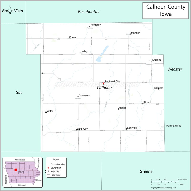
About Calhoun County Map, Iowa: The map showing the county boundary, county seat, major cities, highways, water bodies and neighbouring counties.
More Iowa Maps & Info
| Iowa Map | Iowa County Map | Iowa Cities Map |
| Iowa Zip codes | Where is Iowa | Airports in Iowa |
| Iowa Area Codes | Iowa Blank Map | Iowa River Map |
| Iowa Physical Map | Iowa Road Map | Where is Des Moines |
Map of Calhoun County, Iowa
Calhoun County is a county located in the U.S. state of Iowa. It's county seat is Rockwell City. As per 2020 census, the population of Calhoun County is 9915 people and population density is square miles. According to the United States Census Bureau, the county has a total area of 570 sq mi (1,476 km2). Calhoun County was established on -17881.
Calhoun County Facts
| Continent | North America |
| Country | United States |
| State | Iowa |
| County Seat | Rockwell City |
| Largest City/Town | Rockwell City |
| Established | January 15, 1851 |
| Total Area | 572 sq mi (1,481 sq km) |
| Land Area | 570 sq mi (1,476 sq km) |
| Water Area | 2 sq mi (5 sq km) |
| Population | 9,927 (Census 2020) |
| Population Density | 17.4 people per sq mi |
| Time Zone | Central Time Zone (CT) |
| Major Highways | U.S. Highway 20, Iowa Highway 4, Iowa Highway 7, Iowa Highway 175 |
| Major Rivers | North Raccoon River, Cedar Creek |
| Neighboring Counties | Pocahontas County, Webster County, Greene County, Carroll County, Sac County |
| Famous For | Twin Lakes, agriculture, Manson Impact Crater region, Pomeroy tornado history, rural recreation |
| Top Attractions | Twin Lakes State Park, Manson Impact Crater, Freedom Rock, Calhoun County Courthouse |
| Official Website | Official Website |
About Calhoun County, Iowa
Calhoun County is located in northwestern Iowa and was established in 1851. The county seat is Rockwell City, which is also the largest city. The county is situated within the Des Moines Lobe region, known for its gently rolling glacial landscape, fertile farmland, and numerous natural lakes. Agriculture remains the foundation of the local economy, while Twin Lakes provides one of the county's most popular recreation destinations.
Cities and Towns in Calhoun County, Iowa
| City Name | Type | Population (2020) | Pop. Density | Area | Incorporated |
|---|---|---|---|---|---|
| Batchtown | Village | 170 | 91.3/sq mi (35.2/km2) | 1.863 sq mi (4.83 km2) | |
| Brussels | Village | 116 | 207.9/sq mi (80.3/km2) | 0.558 sq mi (1.45 km2) | |
| Hamburg | Village | 99 | 189.7/sq mi (73.2/km2) | 0.522 sq mi (1.35 km2) | |
| Hardin | Village | 801 | 376.4/sq mi (145.3/km2) | 2.128 sq mi (5.51 km2) | |
| Kampsville | Village | 310 | 303.9/sq mi (117.3/km2) | 1.02 sq mi (2.64 km2) | |
| Jolley | 0.11 sq mi (0.28 km2) | November 16, 1895 | |||
| Knierim | 1.01 sq mi (2.6 km2) | June 13, 1901 | |||
| Lake City | 4.81 sq mi (12.5 km2) | March 14, 1887 | |||
| Lohrville | 2.14 sq mi (5.5 km2) | December 14, 1882 | |||
| Manson | 3.18 sq mi (8.2 km2) | May 5, 1877 | |||
| Pomeroy | 2.04 sq mi (5.3 km2) | April 22, 1880 | |||
| Rinard | 1 sq mi (2.6 km2) | December 29, 1914 | |||
| Rockwell City | 4.21 sq mi (10.9 km2) | May 2, 1882 | |||
| Somers | 0.35 sq mi (0.91 km2) | April 26, 1902 | |||
| Yetter | 0.13 sq mi (0.34 km2) | January 11, 1904 |
Best Golf Courses in Calhoun County, Iowa
| Golf Course | Location | Latitude & Longitude |
|---|---|---|
| Lake City Country Club | Lake City | 42.2664°N, 94.7325°W |
| Twin Lakes Golf Club | Twin Lakes | 42.3078°N, 94.7002°W |
| Manson Golf & Country Club | Manson | 42.5325°N, 94.5451°W |
| Lake Creek Country Club | Rockwell City | 42.4048°N, 94.6450°W |
What are Major Roads and Highways in Calhoun County
Major highways connect the county to nearby regions and cities.
- U.S. Highway 20 - major east-west corridor linking the county with Fort Dodge, Sioux City and surrounding communities
- Iowa Highway 4 - north-south route connecting Manson, Rockwell City and communities across western Iowa
- Iowa Highway 7 - serves northern Calhoun County and connects Manson with neighboring counties
- Iowa Highway 175 - crosses the southern portion of the county and links Lake City with regional communities
Neighboring Counties of Calhoun County
- Pocahontas County (north)
- Webster County (east)
- Greene County (southeast)
- Carroll County (south)
- Sac County (west)
What are Top Attractions in Calhoun County, Iowa
The county offers a mix of natural and cultural attractions.
| Main Sight Name | City | Famous For |
|---|---|---|
| Twin Lakes State Park | Twin Lakes | Boating, fishing, swimming and camping |
| North Twin Lake | Twin Lakes | Popular fishing and water recreation destination |
| South Twin Lake | Twin Lakes | Boating, kayaking and scenic lake views |
| Manson Impact Crater Geological Site | Manson | One of the largest meteor impact structures in North America |
| Calhoun County Courthouse | Rockwell City | Historic 1914 courthouse and county landmark |
| Freedom Rock | Rockwell City | Veterans memorial artwork |
| Rainbow Bridge | Rockwell City | Historic bridge on old Highway 20 |
| Lake City Town Square | Lake City | Historic downtown district and community events |
| Pomeroy Historical Museum | Pomeroy | Local history and tornado heritage exhibits |
| Manson Museum | Manson | Community history and geological exhibits |
| Lohrville City Park | Lohrville | Outdoor recreation and community activities |
| North Raccoon River Corridor | Countywide | Wildlife viewing, fishing and natural scenery |
Distance from Calhoun County to Nearby Cities
The following distances are measured by road (driving).
- Rockwell City to Fort Dodge (Webster County), Iowa - 29 mi (47 km)
- Rockwell City to Pocahontas (Pocahontas County), Iowa - 24 mi (39 km)
- Rockwell City to Sac City (Sac County), Iowa - 22 mi (35 km)
- Rockwell City to Carroll (Carroll County), Iowa - 36 mi (58 km)
- Rockwell City to Jefferson (Greene County), Iowa - 39 mi (63 km)
- Rockwell City to Storm Lake (Buena Vista County), Iowa - 38 mi (61 km)
- Rockwell City to Webster City (Hamilton County), Iowa - 42 mi (68 km)
- Rockwell City to Humboldt (Humboldt County), Iowa - 28 mi (45 km)
- Rockwell City to Denison (Crawford County), Iowa - 57 mi (92 km)
- Rockwell City to Ames (Story County), Iowa - 73 mi (117 km)
- Rockwell City to Mason City (Cerro Gordo County), Iowa - 76 mi (122 km)
- Rockwell City to Sioux City (Woodbury County), Iowa - 96 mi (154 km)
- Rockwell City to Des Moines (Polk County), Iowa - 102 mi (164 km)
- Rockwell City to Council Bluffs (Pottawattamie County), Iowa - 118 mi (190 km)
- Rockwell City to Omaha, Nebraska - 126 mi (203 km)
Nearest Airports
Nearest airport of Calhoun is Peterson Airport.
References
- QuickFacts - U.S. Census Bureau
- United States Census Bureau
- United States Geological Survey (USGS)
- National Geodetic Survey
- Official County Website
- Adair County Map
- Adams County Map
- Allamakee County Map
- Appanoose County Map
- Audubon County Map
- Benton County Map
- Black Hawk County Map
- Boone County Map
- Bremer County Map
- Buchanan County Map
- Buena Vista County Map
- Butler County Map
- Calhoun County Map
- Carroll County Map
- Cass County Map
- Cedar County Map
- Cerro Gordo County Map
- Cherokee County Map
- Chickasaw County Map
- Clarke County Map
- Clay County Map
- Clayton County Map
- Clinton County Map
- Crawford County Map
- Dallas County Map
- Davis County Map
- Decatur County Map
- Delaware County Map
- Des Moines County Map
- Dickinson County Map
- Dubuque County Map
- Emmet County Map
- Fayette County Map
- Floyd County Map
- Franklin County Map
- Fremont County Map
- Greene County Map
- Grundy County Map
- Guthrie County Map
- Hamilton County Map
- Hancock County Map
- Hardin County Map
- Harrison County Map
- Henry County Map
- Howard County Map
- Humboldt County Map
- Ida County Map
- Iowa County Map
- Jackson County Map
- Jasper County Map
- Jefferson County Map
- Johnson County Map
- Jones County Map
- Keokuk County Map
- Kossuth County Map
- Lee County Map
- Linn County Map
- Louisa County Map
- Lucas County Map
- Lyon County Map
- Madison County Map
- Mahaska County Map
- Marion County Map
- Marshall County Map
- Mills County Map
- Mitchell County Map
- Monona County Map
- Monroe County Map
- Montgomery County Map
- Muscatine County Map
- O'Brien County Map
- Osceola County Map
- Page County Map
- Palo Alto County Map
- Plymouth County Map
- Pocahontas County Map
- Polk County Map
- Pottawattamie County Map
- Poweshiek County Map
- Ringgold County Map
- Sac County Map
- Scott County Map
- Shelby County Map
- Sioux County Map
- Story County Map
- Tama County Map
- Taylor County Map
- Union County Map
- Van Buren County Map
- Wapello County Map
- Warren County Map
- Washington County Map
- Wayne County Map
- Webster County Map
- Winnebago County Map
- Winneshiek County Map
- Woodbury County Map
- Worth County Map
- Wright County Map
- Alabama Counties
- Alaska boroughs
- Arizona Counties
- Arkansas Counties
- California County Map
- Colorado Counties
- Connecticut Counties
- Delaware Counties
- Florida County Map
- Georgia County Map
- Hawaii Counties
- Idaho Counties
- Illinois Counties
- Indiana Counties
- Iowa Counties
- Kansas Counties
- Kentucky Counties
- Louisiana Counties
- Maine Counties
- Maryland Counties
- Massachusetts Counties
- Michigan County Map
- Minnesota Counties
- Mississippi Counties
- Missouri Counties
- Montana Counties
- Nebraska Counties
- Nevada Counties
- New York Counties
- New Hampshire Counties
- New Jersey Counties
- New Mexico Counties
- North Carolina Counties
- North Dakota Counties
- Ohio County Map
- Oklahoma Counties
- Oregon Counties
- Pennsylvania Counties
- Rhode Island Counties
- South Carolina Counties
- South Dakota Counties
- Map of Tennessee
- Texas County Map
- Utah Counties
- Vermont Counties
- Virginia Counties
- Washington Counties
- West Virginia Counties
- Wisconsin Counties
- Wyoming Counties