Written and Fact-checked by Whereig Editors | Last Updated On: June 10, 2026
Map of Lucas County - Lucas County is a county located in the U.S. state of Iowa. Lucas County Map showing cities, highways, important places and water bodies. Get Where is Lucas County located in the map, major cities in Lucas county, population, areas, and places of interest.
Lucas County Map, Iowa
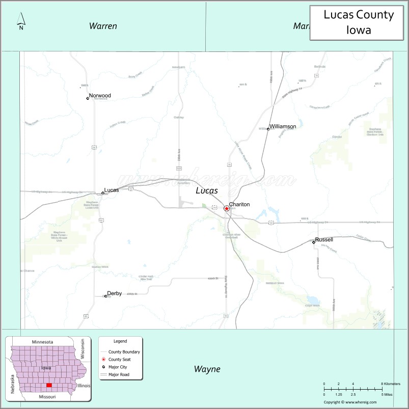
About Lucas County Map, Iowa: The map showing the county boundary, county seat, major cities, highways, water bodies and neighbouring counties.
More Iowa Maps & Info
| Iowa Map | Iowa County Map | Iowa Cities Map |
| Iowa Zip codes | Where is Iowa | Airports in Iowa |
| Iowa Area Codes | Iowa Blank Map | Iowa River Map |
| Iowa Physical Map | Iowa Road Map | Where is Des Moines |
Map of Lucas County, Iowa
Lucas County is a county located in the U.S. state of Iowa. It's county seat is Chariton. As per 2020 census, the population of Lucas County is 8710 people and population density is square miles. According to the United States Census Bureau, the county has a total area of 431 sq mi (1,116 km2). Lucas County was established on -19709.
Lucas County Facts
| Continent | North America |
| Country | United States |
| State | Iowa |
| County Seat | Chariton |
| Largest City/Town | Chariton |
| Established | January 13, 1846 |
| Total Area | 434 sq mi (1,124 sq km) |
| Land Area | 431 sq mi (1,116 sq km) |
| Water Area | 3 sq mi (8 sq km) |
| Population | 8,634 (Census 2020) |
| Population Density | 20.0 people per sq mi |
| Time Zone | Central Time Zone (CT) |
| Major Highways | U.S. Highway 34, Iowa Highway 14, Iowa Highway 5 |
| Major Rivers | Chariton River, White Breast Creek |
| Neighboring Counties | Marion County, Monroe County, Appanoose County, Wayne County, Clarke County, Warren County |
| Famous For | Red Haw State Park, Stephens State Forest, coal mining history, Chariton |
| Top Attractions | Red Haw State Park, Stephens State Forest, Lucas County Historical Museum, Johnson Machine Works Nature Trail |
| Official Website | Official Website |
About Lucas County, Iowa
Lucas County is located in south-central Iowa and was established in 1846. The county seat and largest city is Chariton. The county is known for its rolling countryside, coal mining heritage, outdoor recreation areas, and agricultural economy. Large forested areas and scenic waterways make it a popular destination for camping, hiking, fishing, and wildlife viewing. :contentReference[oaicite:0]{index=0}
Cities and Towns in Lucas County, Iowa
| City/Town | Population (Census 2020) | Latitude & Longitude |
|---|---|---|
| Chariton (county seat) | 4,193 | 41.0139°N, 93.3063°W |
| Russell | 554 | 40.9969°N, 93.1974°W |
| Williamson | 152 | 41.0796°N, 93.2694°W |
| Lucas | 172 | 41.0224°N, 93.4613°W |
| Derby | 90 | 40.9386°N, 93.4779°W |
Best Golf Courses in Lucas County, Iowa
| Golf Course | Location | Latitude & Longitude |
|---|---|---|
| Chariton Country Club | Chariton | 41.0275°N, 93.3004°W |
| Red Haw Golf & Country Club | Chariton | 41.0114°N, 93.2898°W |
What are Major Roads and Highways in Lucas County
Major highways connect the county to nearby regions and cities.
- U.S. Highway 34 - east-west route connecting Chariton with Creston, Albia, and southern Iowa communities
- Iowa Highway 14 - north-south route connecting Chariton with Knoxville and Leon
- Iowa Highway 5 - passes through the southern part of the county and connects to Centerville and Interstate 35
Neighboring Counties of Lucas County
- Marion County (north)
- Monroe County (east)
- Appanoose County (southeast)
- Wayne County (south)
- Clarke County (west)
- Warren County (northwest)
What are Top Attractions in Lucas County, Iowa
The county offers a mix of natural and cultural attractions.
| Main Sight Name | City | Famous For |
|---|---|---|
| Red Haw State Park | Chariton | Lake recreation, hiking, camping, and fishing |
| Stephens State Forest | Lucas | One of Iowa's largest state forests |
| Lucas County Historical Museum | Chariton | Local history exhibits and artifacts |
| Johnson Machine Works Nature Trail | Chariton | Walking trails and wildlife viewing |
| Chariton Square Historic District | Chariton | Historic downtown architecture |
| Lake Ellis | Chariton | Fishing and outdoor recreation |
| Coal Mining Heritage Sites | Lucas | Historic mining landmarks |
| Derby Community Park | Derby | Local recreation and events |
| Williamson City Park | Williamson | Small-town outdoor recreation |
| Russell Community Center Area | Russell | Community events and gatherings |
Distance from Lucas County to Nearby Cities
The following distances are measured by road (driving).
- Chariton to Russell (Lucas County), Iowa - 8 mi (13 km)
- Chariton to Lucas (Lucas County), Iowa - 10 mi (16 km)
- Chariton to Albia (Monroe County), Iowa - 26 mi (42 km)
- Chariton to Knoxville (Marion County), Iowa - 31 mi (50 km)
- Chariton to Osceola (Clarke County), Iowa - 32 mi (51 km)
- Chariton to Corydon (Wayne County), Iowa - 28 mi (45 km)
- Chariton to Centerville (Appanoose County), Iowa - 36 mi (58 km)
- Chariton to Indianola (Warren County), Iowa - 47 mi (76 km)
- Chariton to Pella (Marion County), Iowa - 45 mi (72 km)
- Chariton to Oskaloosa (Mahaska County), Iowa - 49 mi (79 km)
- Chariton to Des Moines (Polk County), Iowa - 55 mi (89 km)
- Chariton to Ottumwa (Wapello County), Iowa - 57 mi (92 km)
- Chariton to Creston (Union County), Iowa - 45 mi (72 km)
- Chariton to Ames (Story County), Iowa - 92 mi (148 km)
- Chariton to Cedar Rapids (Linn County), Iowa - 118 mi (190 km)
Nearest Airports
Nearest airport of Lucas is Des Moines International Airport (DSM / KDSM).
References
- QuickFacts - U.S. Census Bureau
- United States Census Bureau Profile
- United States Geological Survey (USGS)
- National Geodetic Survey
- Official Lucas County Website
- Adair County Map
- Adams County Map
- Allamakee County Map
- Appanoose County Map
- Audubon County Map
- Benton County Map
- Black Hawk County Map
- Boone County Map
- Bremer County Map
- Buchanan County Map
- Buena Vista County Map
- Butler County Map
- Calhoun County Map
- Carroll County Map
- Cass County Map
- Cedar County Map
- Cerro Gordo County Map
- Cherokee County Map
- Chickasaw County Map
- Clarke County Map
- Clay County Map
- Clayton County Map
- Clinton County Map
- Crawford County Map
- Dallas County Map
- Davis County Map
- Decatur County Map
- Delaware County Map
- Des Moines County Map
- Dickinson County Map
- Dubuque County Map
- Emmet County Map
- Fayette County Map
- Floyd County Map
- Franklin County Map
- Fremont County Map
- Greene County Map
- Grundy County Map
- Guthrie County Map
- Hamilton County Map
- Hancock County Map
- Hardin County Map
- Harrison County Map
- Henry County Map
- Howard County Map
- Humboldt County Map
- Ida County Map
- Iowa County Map
- Jackson County Map
- Jasper County Map
- Jefferson County Map
- Johnson County Map
- Jones County Map
- Keokuk County Map
- Kossuth County Map
- Lee County Map
- Linn County Map
- Louisa County Map
- Lucas County Map
- Lyon County Map
- Madison County Map
- Mahaska County Map
- Marion County Map
- Marshall County Map
- Mills County Map
- Mitchell County Map
- Monona County Map
- Monroe County Map
- Montgomery County Map
- Muscatine County Map
- O'Brien County Map
- Osceola County Map
- Page County Map
- Palo Alto County Map
- Plymouth County Map
- Pocahontas County Map
- Polk County Map
- Pottawattamie County Map
- Poweshiek County Map
- Ringgold County Map
- Sac County Map
- Scott County Map
- Shelby County Map
- Sioux County Map
- Story County Map
- Tama County Map
- Taylor County Map
- Union County Map
- Van Buren County Map
- Wapello County Map
- Warren County Map
- Washington County Map
- Wayne County Map
- Webster County Map
- Winnebago County Map
- Winneshiek County Map
- Woodbury County Map
- Worth County Map
- Wright County Map
- Alabama Counties
- Alaska boroughs
- Arizona Counties
- Arkansas Counties
- California County Map
- Colorado Counties
- Connecticut Counties
- Delaware Counties
- Florida County Map
- Georgia County Map
- Hawaii Counties
- Idaho Counties
- Illinois Counties
- Indiana Counties
- Iowa Counties
- Kansas Counties
- Kentucky Counties
- Louisiana Counties
- Maine Counties
- Maryland Counties
- Massachusetts Counties
- Michigan County Map
- Minnesota Counties
- Mississippi Counties
- Missouri Counties
- Montana Counties
- Nebraska Counties
- Nevada Counties
- New York Counties
- New Hampshire Counties
- New Jersey Counties
- New Mexico Counties
- North Carolina Counties
- North Dakota Counties
- Ohio County Map
- Oklahoma Counties
- Oregon Counties
- Pennsylvania Counties
- Rhode Island Counties
- South Carolina Counties
- South Dakota Counties
- Map of Tennessee
- Texas County Map
- Utah Counties
- Vermont Counties
- Virginia Counties
- Washington Counties
- West Virginia Counties
- Wisconsin Counties
- Wyoming Counties