Written and Fact-checked by Whereig Editors | Last Updated On: June 10, 2026
Map of Page County - Page County is a county located in the U.S. state of Iowa. Page County Map showing cities, highways, important places and water bodies. Get Where is Page County located in the map, major cities in Page county, population, areas, and places of interest.
Page County Map, Iowa
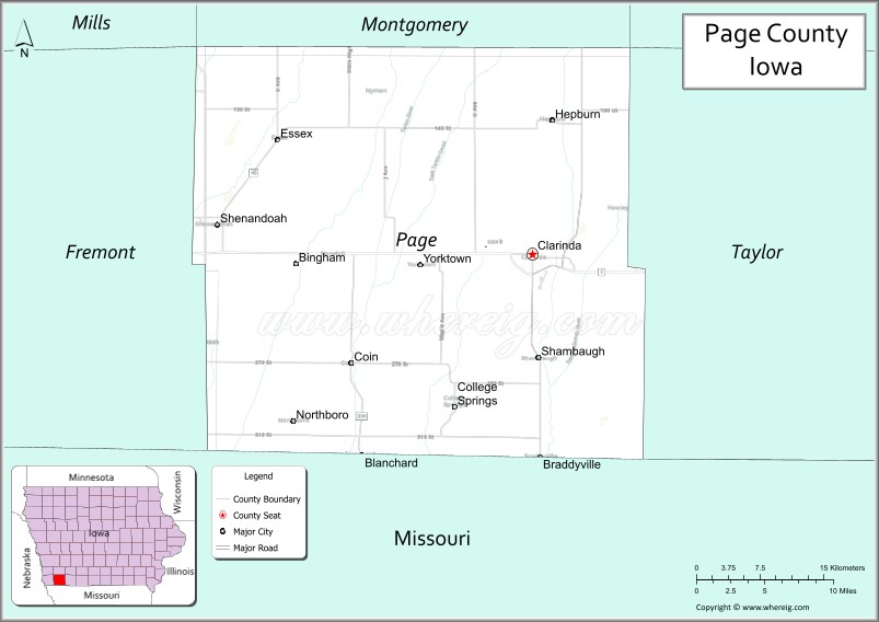
About Page County Map, Iowa: The map showing the county boundary, county seat, major cities, highways, water bodies and neighbouring counties.
More Iowa Maps & Info
| Iowa Map | Iowa County Map | Iowa Cities Map |
| Iowa Zip codes | Where is Iowa | Airports in Iowa |
| Iowa Area Codes | Iowa Blank Map | Iowa River Map |
| Iowa Physical Map | Iowa Road Map | Where is Des Moines |
Map of Page County, Iowa
Page County is a county located in the U.S. state of Iowa. It's county seat is Clarinda. As per 2020 census, the population of Page County is 15197 people and population density is square miles. According to the United States Census Bureau, the county has a total area of 535 sq mi (1,386 km2). Page County was established on -19302.
Page County Facts
| Continent | North America |
| Country | United States |
| State | Iowa |
| County Seat | Clarinda |
| Largest City/Town | Clarinda |
| Established | February 24, 1847 |
| Total Area | 535 sq mi (1,386 sq km) |
| Land Area | 535 sq mi (1,386 sq km) |
| Water Area | 0.3 sq mi (0.8 sq km) |
| Population | 15,095 (Census 2020) |
| Population Density | 28.2 people per sq mi |
| Time Zone | Central Time Zone (CT) |
| Major Highways | U.S. Highway 71, U.S. Highway 2, Iowa Highway 48 |
| Major Rivers | Nodaway River, East Nishnabotna River |
| Neighboring Counties | Montgomery County, Adams County, Taylor County, Fremont County, Nodaway County (MO) |
| Famous For | Clarinda, Glenn Miller birthplace, agricultural heritage, Nodaway Valley |
| Top Attractions | Glenn Miller Birthplace Museum, Clarinda Carnegie Art Museum, Page County Historical Museum, Sportsman Park |
| Official Website | Official Website |
About Page County, Iowa
Page County is located in southwestern Iowa along the Missouri border and was established in 1847. The county seat and largest city is Clarinda. The county is best known as the birthplace of legendary bandleader Glenn Miller and for its rich agricultural traditions. Rolling farmland, historic communities, and cultural attractions make Page County an important part of southwestern Iowa.
Cities and Towns in Page County, Iowa
| City/Town | Population (Census 2020) | Latitude & Longitude |
|---|---|---|
| Clarinda (county seat) | 5,369 | 40.7397°N, 95.0380°W |
| Shenandoah | 5,150 | 40.7650°N, 95.3725°W |
| Essex | 730 | 40.8242°N, 95.3083°W |
| Coin | 193 | 40.6555°N, 95.2194°W |
| College Springs | 208 | 40.6203°N, 95.1108°W |
| Northboro | 58 | 40.6041°N, 95.3227°W |
| Braddyville | 159 | 40.5836°N, 95.1297°W |
| Blanchard | 38 | 40.5800°N, 95.2167°W |
| Hepburn | 22 | 40.6947°N, 95.3881°W |
| New Market | 355 | 40.7197°N, 95.0050°W |
Best Golf Courses in Page County, Iowa
| Golf Course | Location | Latitude & Longitude |
|---|---|---|
| Clarinda Country Club | Clarinda | 40.7448°N, 95.0565°W |
| Shenandoah Medical Center Golf Course | Shenandoah | 40.7684°N, 95.3807°W |
| Essex Golf Club | Essex | 40.8278°N, 95.3146°W |
What are Major Roads and Highways in Page County
Major highways connect the county to nearby regions and cities.
- U.S. Highway 71 - major north-south route connecting Clarinda with Carroll and Missouri communities
- U.S. Highway 2 - east-west corridor serving southern Iowa and linking Shenandoah and Clarinda
- Iowa Highway 48 - regional route connecting Page County with Montgomery and Fremont counties
Neighboring Counties of Page County
- Montgomery County (north)
- Adams County (east)
- Taylor County (south)
- Fremont County (west)
- Nodaway County, Missouri (south)
What are Top Attractions in Page County, Iowa
The county offers a mix of natural and cultural attractions.
| Main Sight Name | City | Famous For |
|---|---|---|
| Glenn Miller Birthplace Museum | Clarinda | Birthplace and memorabilia of the famous bandleader |
| Clarinda Carnegie Art Museum | Clarinda | Regional art collections and exhibits |
| Page County Historical Museum | Clarinda | County history and pioneer artifacts |
| Sportsman Park | Shenandoah | Fishing, camping, and outdoor recreation |
| Wabash Trace Nature Trail | Shenandoah | Popular biking and hiking trail |
| Greater Shenandoah Historical Museum | Shenandoah | Local history and seed industry heritage |
| Clarinda Lied Public Library | Clarinda | Historic community landmark |
| Nodaway Valley Scenic Areas | Countywide | Rural landscapes and wildlife viewing |
| College Springs Heritage Area | College Springs | Historic educational community |
| Essex Community Park | Essex | Family recreation and events |
| Clarinda Municipal Airport Museum Displays | Clarinda | Aviation and local history exhibits |
| Page County Fairgrounds | Clarinda | Agricultural fairs and annual events |
Distance from Page County to Nearby Cities
The following distances are measured by road (driving).
- Clarinda to Shenandoah (Page County), Iowa - 17 mi (27 km)
- Clarinda to Essex (Page County), Iowa - 17 mi (27 km)
- Clarinda to New Market (Page County), Iowa - 9 mi (14 km)
- Clarinda to Red Oak (Montgomery County), Iowa - 32 mi (52 km)
- Clarinda to Corning (Adams County), Iowa - 31 mi (50 km)
- Clarinda to Bedford (Taylor County), Iowa - 26 mi (42 km)
- Clarinda to Sidney (Fremont County), Iowa - 32 mi (52 km)
- Clarinda to Maryville, Missouri - 28 mi (45 km)
- Clarinda to Nebraska City, Nebraska - 55 mi (89 km)
- Clarinda to Council Bluffs (Pottawattamie County), Iowa - 71 mi (114 km)
- Clarinda to Omaha, Nebraska - 78 mi (126 km)
- Clarinda to Des Moines (Polk County), Iowa - 102 mi (164 km)
- Clarinda to Sioux City (Woodbury County), Iowa - 163 mi (262 km)
- Clarinda to Cedar Rapids (Linn County), Iowa - 217 mi (349 km)
- Clarinda to Kansas City, Missouri - 113 mi (182 km)
Nearest Airports
Nearest airport of Page is Des Moines (DSM) Airport.
References
- QuickFacts - U.S. Census Bureau
- United States Census Bureau
- United States Geological Survey (USGS)
- National Geodetic Survey
- Official Page County Website
- Adair County Map
- Adams County Map
- Allamakee County Map
- Appanoose County Map
- Audubon County Map
- Benton County Map
- Black Hawk County Map
- Boone County Map
- Bremer County Map
- Buchanan County Map
- Buena Vista County Map
- Butler County Map
- Calhoun County Map
- Carroll County Map
- Cass County Map
- Cedar County Map
- Cerro Gordo County Map
- Cherokee County Map
- Chickasaw County Map
- Clarke County Map
- Clay County Map
- Clayton County Map
- Clinton County Map
- Crawford County Map
- Dallas County Map
- Davis County Map
- Decatur County Map
- Delaware County Map
- Des Moines County Map
- Dickinson County Map
- Dubuque County Map
- Emmet County Map
- Fayette County Map
- Floyd County Map
- Franklin County Map
- Fremont County Map
- Greene County Map
- Grundy County Map
- Guthrie County Map
- Hamilton County Map
- Hancock County Map
- Hardin County Map
- Harrison County Map
- Henry County Map
- Howard County Map
- Humboldt County Map
- Ida County Map
- Iowa County Map
- Jackson County Map
- Jasper County Map
- Jefferson County Map
- Johnson County Map
- Jones County Map
- Keokuk County Map
- Kossuth County Map
- Lee County Map
- Linn County Map
- Louisa County Map
- Lucas County Map
- Lyon County Map
- Madison County Map
- Mahaska County Map
- Marion County Map
- Marshall County Map
- Mills County Map
- Mitchell County Map
- Monona County Map
- Monroe County Map
- Montgomery County Map
- Muscatine County Map
- O'Brien County Map
- Osceola County Map
- Page County Map
- Palo Alto County Map
- Plymouth County Map
- Pocahontas County Map
- Polk County Map
- Pottawattamie County Map
- Poweshiek County Map
- Ringgold County Map
- Sac County Map
- Scott County Map
- Shelby County Map
- Sioux County Map
- Story County Map
- Tama County Map
- Taylor County Map
- Union County Map
- Van Buren County Map
- Wapello County Map
- Warren County Map
- Washington County Map
- Wayne County Map
- Webster County Map
- Winnebago County Map
- Winneshiek County Map
- Woodbury County Map
- Worth County Map
- Wright County Map
- Alabama Counties
- Alaska boroughs
- Arizona Counties
- Arkansas Counties
- California County Map
- Colorado Counties
- Connecticut Counties
- Delaware Counties
- Florida County Map
- Georgia County Map
- Hawaii Counties
- Idaho Counties
- Illinois Counties
- Indiana Counties
- Iowa Counties
- Kansas Counties
- Kentucky Counties
- Louisiana Counties
- Maine Counties
- Maryland Counties
- Massachusetts Counties
- Michigan County Map
- Minnesota Counties
- Mississippi Counties
- Missouri Counties
- Montana Counties
- Nebraska Counties
- Nevada Counties
- New York Counties
- New Hampshire Counties
- New Jersey Counties
- New Mexico Counties
- North Carolina Counties
- North Dakota Counties
- Ohio County Map
- Oklahoma Counties
- Oregon Counties
- Pennsylvania Counties
- Rhode Island Counties
- South Carolina Counties
- South Dakota Counties
- Map of Tennessee
- Texas County Map
- Utah Counties
- Vermont Counties
- Virginia Counties
- Washington Counties
- West Virginia Counties
- Wisconsin Counties
- Wyoming Counties