Written and Fact-checked by Whereig Editors | Last Updated On: June 10, 2026
Map of Allamakee County - Allamakee County is a county located in the U.S. state of Iowa. Allamakee County Map showing cities, highways, important places and water bodies. Get Where is Allamakee County located in the map, major cities in Allamakee county, population, areas, and places of interest.
Allamakee County Map, Iowa
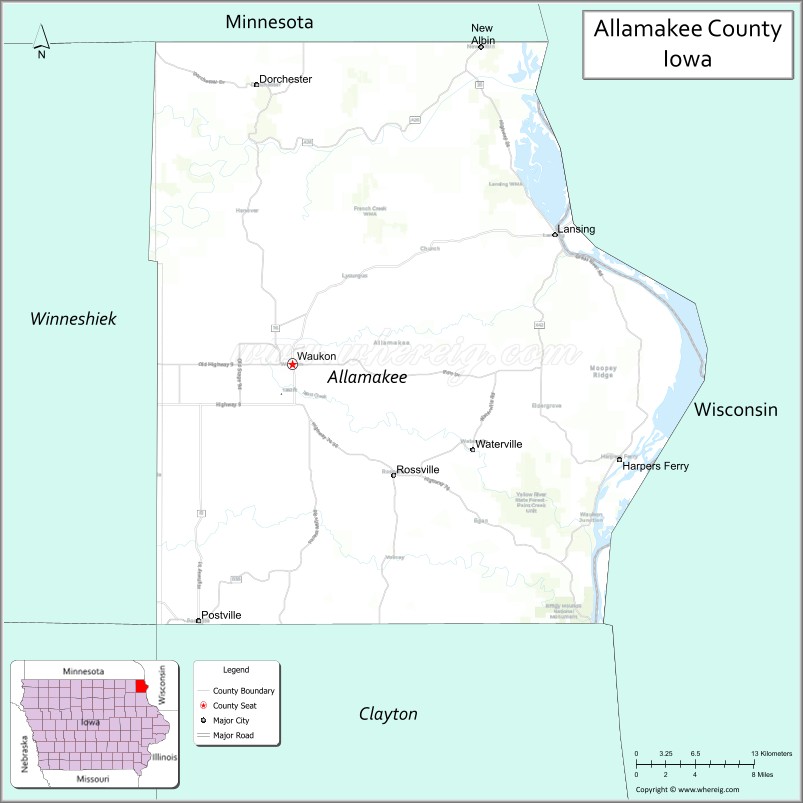
About Allamakee County Map, Iowa: The map showing the county boundary, county seat, major cities, highways, water bodies and neighbouring counties.
More Iowa Maps & Info
| Iowa Map | Iowa County Map | Iowa Cities Map |
| Iowa Zip codes | Where is Iowa | Airports in Iowa |
| Iowa Area Codes | Iowa Blank Map | Iowa River Map |
| Iowa Physical Map | Iowa Road Map | Where is Des Moines |
Map of Allamakee County, Iowa
Allamakee County is a county located in the U.S. state of Iowa. It's county seat is Waukon. As per 2020 census, the population of Allamakee County is 13926 people and population density is square miles. According to the United States Census Bureau, the county has a total area of 640 sq mi (1,658 km2). Allamakee County was established on -19306.
Allamakee County Facts
| Continent | North America |
| Country | United States |
| State | Iowa |
| County Seat | Waukon |
| Largest City/Town | Waukon |
| Established | 1847 |
| Total Area | 659 sq mi (1,707 sq km) |
| Land Area | 639 sq mi (1,655 sq km) |
| Water Area | 20 sq mi (52 sq km) |
| Population | 14,061 (Census 2020) |
| Population Density | 22.0 people per sq mi |
| Time Zone | Central Time Zone (CT) |
| Major Highways | U.S. Highway 18, U.S. Highway 52, Iowa Highway 9, Iowa Highway 26, Iowa Highway 76 |
| Major Rivers | Mississippi River, Upper Iowa River, Yellow River |
| Neighboring Counties | Houston County (MN), Vernon County (WI), Crawford County (WI), Clayton County, Winneshiek County, Fayette County |
| Famous For | Effigy Mounds National Monument, Yellow River State Forest, Driftless Area landscapes, Mississippi River bluffs |
| Top Attractions | Effigy Mounds National Monument, Yellow River State Forest, Mount Hosmer, Mississippi River |
| Official Website | Official Website |
About Allamakee County, Iowa
Allamakee County is located in the northeastern corner of Iowa and was established in 1847. The county seat is Waukon, which is also the largest city. The county lies within Iowa's scenic Driftless Area, a region known for steep bluffs, deep valleys, and landscapes untouched by glaciers. The Mississippi River forms the county's eastern border and contributes to its outdoor recreation and tourism economy.
Cities and Towns in Allamakee County, Iowa
| City/Town | Population (Census 2020) | Latitude & Longitude |
|---|---|---|
| Waukon (county seat) | 3,827 | 43.2697°N, 91.4757°W |
| Postville | 2,228 | 43.0858°N, 91.5682°W |
| Lansing | 968 | 43.3617°N, 91.2182°W |
| New Albin | 432 | 43.4976°N, 91.2890°W |
| Harpers Ferry | 262 | 43.2035°N, 91.3895°W |
| Waterville | 109 | 43.1940°N, 91.2986°W |
Best Golf Courses in Allamakee County, Iowa
| Golf Course | Location | Latitude & Longitude |
|---|---|---|
| Waukon Golf & Country Club | Waukon | 43.2560°N, 91.4940°W |
| Lansing Country Club | Lansing | 43.3794°N, 91.2340°W |
What are Major Roads and Highways in Allamakee County
Major highways connect the county to nearby regions and cities.
- U.S. Highway 18 - crosses the county west to east and connects Postville, Waukon and neighboring counties
- U.S. Highway 52 - serves the southwestern part of the county and connects to Decorah and Dubuque
- Iowa Highway 9 - provides access to Lansing and the Mississippi River corridor
- Iowa Highway 26 - follows the Mississippi River and links Lansing with river communities
- Iowa Highway 76 - connects Waukon with rural northern Allamakee County and Minnesota
Neighboring Counties of Allamakee County
- Houston County, Minnesota (north)
- Vernon County, Wisconsin (northeast)
- Crawford County, Wisconsin (east)
- Clayton County, Iowa (south)
- Fayette County, Iowa (southwest)
- Winneshiek County, Iowa (west)
What are Top Attractions in Allamakee County, Iowa
The county offers a mix of natural and cultural attractions.
| Main Sight Name | City | Famous For |
|---|---|---|
| Effigy Mounds National Monument | Harpers Ferry | Ancient Native American mound structures and hiking trails |
| Yellow River State Forest | Harpers Ferry | Camping, hiking, trout streams and scenic valleys |
| Mount Hosmer | Lansing | Panoramic views of the Mississippi River Valley |
| Upper Mississippi River National Wildlife and Fish Refuge | Lansing | Wildlife viewing, boating and birdwatching |
| Driftless Area Scenic Byway | Countywide | Scenic driving route through rugged terrain |
| Lansing Fish Hatchery | Lansing | Historic fish hatchery and educational exhibits |
| Allamakee County Historical Museum | Waukon | County history and local heritage exhibits |
| Stone School Museum | Lansing | Historic school building and local history |
| Village Creek Area | Rural Allamakee County | Scenic trout streams and outdoor recreation |
| Black Hawk Bridge Area | Lansing | Historic Mississippi River crossing location |
| Iowa River Access Sites | New Albin | Fishing, kayaking and wildlife observation |
| Paint Creek Unit | Waukon | Trout fishing and natural scenery |
Distance from Allamakee County to Nearby Cities
The following distances are measured by road (driving).
- Waukon to Decorah (Winneshiek County), Iowa - 17 mi (27 km)
- Waukon to Postville (Allamakee County), Iowa - 18 mi (29 km)
- Waukon to Lansing (Allamakee County), Iowa - 18 mi (29 km)
- Waukon to Monona (Clayton County), Iowa - 23 mi (37 km)
- Waukon to Prairie du Chien, Wisconsin - 33 mi (53 km)
- Waukon to Elkader (Clayton County), Iowa - 39 mi (63 km)
- Waukon to West Union (Fayette County), Iowa - 34 mi (55 km)
- Waukon to Caledonia, Minnesota - 31 mi (50 km)
- Waukon to La Crosse, Wisconsin - 56 mi (90 km)
- Waukon to Cresco (Howard County), Iowa - 47 mi (76 km)
- Waukon to Oelwein (Fayette County), Iowa - 55 mi (89 km)
- Waukon to Dubuque (Dubuque County), Iowa - 84 mi (135 km)
- Waukon to Rochester, Minnesota - 87 mi (140 km)
- Waukon to Waterloo (Black Hawk County), Iowa - 90 mi (145 km)
- Waukon to Cedar Rapids (Linn County), Iowa - 116 mi (187 km)
Nearest Airports
Nearest airport of Allamakee is La Crosse Municipal Airport (LSE / KLSE).
References
- QuickFacts - U.S. Census Bureau
- United States Census Bureau
- United States Geological Survey (USGS)
- National Geodetic Survey
- Official County Website
- Adair County Map
- Adams County Map
- Allamakee County Map
- Appanoose County Map
- Audubon County Map
- Benton County Map
- Black Hawk County Map
- Boone County Map
- Bremer County Map
- Buchanan County Map
- Buena Vista County Map
- Butler County Map
- Calhoun County Map
- Carroll County Map
- Cass County Map
- Cedar County Map
- Cerro Gordo County Map
- Cherokee County Map
- Chickasaw County Map
- Clarke County Map
- Clay County Map
- Clayton County Map
- Clinton County Map
- Crawford County Map
- Dallas County Map
- Davis County Map
- Decatur County Map
- Delaware County Map
- Des Moines County Map
- Dickinson County Map
- Dubuque County Map
- Emmet County Map
- Fayette County Map
- Floyd County Map
- Franklin County Map
- Fremont County Map
- Greene County Map
- Grundy County Map
- Guthrie County Map
- Hamilton County Map
- Hancock County Map
- Hardin County Map
- Harrison County Map
- Henry County Map
- Howard County Map
- Humboldt County Map
- Ida County Map
- Iowa County Map
- Jackson County Map
- Jasper County Map
- Jefferson County Map
- Johnson County Map
- Jones County Map
- Keokuk County Map
- Kossuth County Map
- Lee County Map
- Linn County Map
- Louisa County Map
- Lucas County Map
- Lyon County Map
- Madison County Map
- Mahaska County Map
- Marion County Map
- Marshall County Map
- Mills County Map
- Mitchell County Map
- Monona County Map
- Monroe County Map
- Montgomery County Map
- Muscatine County Map
- O'Brien County Map
- Osceola County Map
- Page County Map
- Palo Alto County Map
- Plymouth County Map
- Pocahontas County Map
- Polk County Map
- Pottawattamie County Map
- Poweshiek County Map
- Ringgold County Map
- Sac County Map
- Scott County Map
- Shelby County Map
- Sioux County Map
- Story County Map
- Tama County Map
- Taylor County Map
- Union County Map
- Van Buren County Map
- Wapello County Map
- Warren County Map
- Washington County Map
- Wayne County Map
- Webster County Map
- Winnebago County Map
- Winneshiek County Map
- Woodbury County Map
- Worth County Map
- Wright County Map
- Alabama Counties
- Alaska boroughs
- Arizona Counties
- Arkansas Counties
- California County Map
- Colorado Counties
- Connecticut Counties
- Delaware Counties
- Florida County Map
- Georgia County Map
- Hawaii Counties
- Idaho Counties
- Illinois Counties
- Indiana Counties
- Iowa Counties
- Kansas Counties
- Kentucky Counties
- Louisiana Counties
- Maine Counties
- Maryland Counties
- Massachusetts Counties
- Michigan County Map
- Minnesota Counties
- Mississippi Counties
- Missouri Counties
- Montana Counties
- Nebraska Counties
- Nevada Counties
- New York Counties
- New Hampshire Counties
- New Jersey Counties
- New Mexico Counties
- North Carolina Counties
- North Dakota Counties
- Ohio County Map
- Oklahoma Counties
- Oregon Counties
- Pennsylvania Counties
- Rhode Island Counties
- South Carolina Counties
- South Dakota Counties
- Map of Tennessee
- Texas County Map
- Utah Counties
- Vermont Counties
- Virginia Counties
- Washington Counties
- West Virginia Counties
- Wisconsin Counties
- Wyoming Counties