Written and Fact-checked by Whereig Editors | Last Updated On: June 10, 2026
Map of Decatur County - Decatur County is a county located in the U.S. state of Iowa. Decatur County Map showing cities, highways, important places and water bodies. Get Where is Decatur County located in the map, major cities in Decatur county, population, areas, and places of interest.
Decatur County Map, Iowa
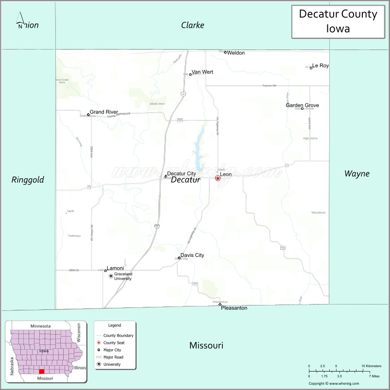
About Decatur County Map, Iowa: The map showing the county boundary, county seat, major cities, highways, water bodies and neighbouring counties.
More Iowa Maps & Info
| Iowa Map | Iowa County Map | Iowa Cities Map |
| Iowa Zip codes | Where is Iowa | Airports in Iowa |
| Iowa Area Codes | Iowa Blank Map | Iowa River Map |
| Iowa Physical Map | Iowa Road Map | Where is Des Moines |
Map of Decatur County, Iowa
Decatur County is a county located in the U.S. state of Iowa. It's county seat is Leon. As per 2020 census, the population of Decatur County is 7659 people and population density is square miles. According to the United States Census Bureau, the county has a total area of 532 sq mi (1,378 km2). Decatur County was established on -19709.
Decatur County Facts
| Continent | North America |
| Country | United States |
| State | Iowa |
| County Seat | Leon |
| Largest City/Town | Leon |
| Established | January 13, 1846 |
| Total Area | 533 sq mi (1,380 sq km) |
| Land Area | 532 sq mi (1,378 sq km) |
| Water Area | 1 sq mi (2 sq km) |
| Population | 7,645 (Census 2020) |
| Population Density | 14.4 people per sq mi |
| Time Zone | Central Time Zone (CT) |
| Major Highways | Interstate 35, U.S. Highway 69, Iowa Highway 2 |
| Major Rivers | Grand River, Weldon River, Little River |
| Neighboring Counties | Clarke County, Lucas County, Wayne County, Ringgold County, Mercer County (MO), Harrison County (MO) |
| Famous For | Little River Lake Recreation Area, Nine Eagles State Park, Amish communities, southern Iowa countryside |
| Top Attractions | Nine Eagles State Park, Little River Recreation Area, Decatur County Museum, Slip Bluff County Park |
| Official Website | Official Website |
About Decatur County, Iowa
Decatur County is located in south-central Iowa along the Missouri border and was established in 1846. The county seat is Leon, which is also the largest city. The county is known for its rolling hills, scenic lakes, wildlife areas, and outdoor recreation opportunities. Agriculture remains important to the local economy, while parks and conservation areas attract visitors throughout the year.
Cities and Towns in Decatur County, Iowa
| City/Town | Population (Census 2020) | Latitude & Longitude |
|---|---|---|
| Leon (county seat) | 1,822 | 40.7392°N, 93.7474°W |
| Lamoni | 2,324 | 40.6236°N, 93.9347°W |
| Davis City | 173 | 40.6386°N, 93.8127°W |
| Garden Grove | 195 | 40.7878°N, 93.6158°W |
| Grand River | 236 | 40.8158°N, 93.9528°W |
| Van Wert | 177 | 40.8708°N, 93.8213°W |
| Pleasanton | 37 | 40.8086°N, 93.2857°W |
| Kellerton | 315 | 40.8564°N, 94.0557°W |
| Decatur City | 149 | 40.7381°N, 93.7868°W |
| High Point | 29 | 40.7036°N, 93.6029°W |
| Weldon | 125 | 40.8769°N, 93.7357°W |
| Le Roy | 11 | 40.8789°N, 93.5825°W |
Best Golf Courses in Decatur County, Iowa
| Golf Course | Location | Latitude & Longitude |
|---|---|---|
| Leon Golf & Country Club | Leon | 40.7361°N, 93.7665°W |
| Lamoni Golf & Country Club | Lamoni | 40.6207°N, 93.9448°W |
| Little River Recreation Area Golf Course | Leon Area | 40.7228°N, 93.7389°W |
What are Major Roads and Highways in Decatur County
Major highways connect the county to nearby regions and cities.
- Interstate 35 - major north-south interstate connecting Decatur County with Des Moines, Kansas City, and surrounding regions
- U.S. Highway 69 - parallels Interstate 35 and serves Lamoni, Leon, and nearby communities
- Iowa Highway 2 - east-west route connecting Decatur County with southern Iowa counties and regional destinations
Neighboring Counties of Decatur County
- Clarke County (north)
- Lucas County (northeast)
- Wayne County (east)
- Ringgold County (west)
- Mercer County, Missouri (south)
- Harrison County, Missouri (southeast)
What are Top Attractions in Decatur County, Iowa
The county offers a mix of natural and cultural attractions.
| Main Sight Name | City | Famous For |
|---|---|---|
| Nine Eagles State Park | Davis City Area | Camping, hiking, fishing, and wildlife viewing |
| Little River Recreation Area | Leon | Boating, fishing, camping, and lake recreation |
| Decatur County Historical Museum | Leon | County history exhibits and pioneer artifacts |
| Slip Bluff County Park | Leon Area | Scenic overlooks and outdoor recreation |
| Graceland University Campus | Lamoni | Historic university and cultural events |
| Little River Lake | Leon Area | Fishing, boating, and camping opportunities |
| Leon Town Square | Leon | Historic courthouse square and local shops |
| Garden Grove Historic Trail Site | Garden Grove | Mormon Trail history landmark |
| Weldon River Corridor | Countywide | Wildlife habitat and scenic landscapes |
| Lamoni Community Center | Lamoni | Community events and regional gatherings |
| Grand River Wildlife Area | Countywide | Outdoor recreation and hunting opportunities |
| Kellerton Heritage Park | Kellerton | Local history and family recreation |
Distance from Decatur County to Nearby Cities
The following distances are measured by road (driving).
- Leon to Osceola (Clarke County), Iowa - 31 mi (50 km)
- Leon to Chariton (Lucas County), Iowa - 39 mi (63 km)
- Leon to Corydon (Wayne County), Iowa - 28 mi (45 km)
- Leon to Mount Ayr (Ringgold County), Iowa - 32 mi (52 km)
- Leon to Lamoni (Decatur County), Iowa - 12 mi (19 km)
- Leon to Creston (Union County), Iowa - 44 mi (71 km)
- Leon to Indianola (Warren County), Iowa - 63 mi (101 km)
- Leon to Des Moines (Polk County), Iowa - 72 mi (116 km)
- Leon to Ottumwa (Wapello County), Iowa - 79 mi (127 km)
- Leon to Council Bluffs (Pottawattamie County), Iowa - 113 mi (182 km)
- Leon to Bethany, Missouri - 25 mi (40 km)
- Leon to Trenton, Missouri - 58 mi (93 km)
- Leon to St. Joseph, Missouri - 97 mi (156 km)
- Leon to Kansas City, Missouri - 112 mi (180 km)
- Leon to Omaha, Nebraska - 141 mi (227 km)
References
- QuickFacts - U.S. Census Bureau
- United States Census Bureau
- United States Geological Survey (USGS)
- National Geodetic Survey
- Official County Website
- Adair County Map
- Adams County Map
- Allamakee County Map
- Appanoose County Map
- Audubon County Map
- Benton County Map
- Black Hawk County Map
- Boone County Map
- Bremer County Map
- Buchanan County Map
- Buena Vista County Map
- Butler County Map
- Calhoun County Map
- Carroll County Map
- Cass County Map
- Cedar County Map
- Cerro Gordo County Map
- Cherokee County Map
- Chickasaw County Map
- Clarke County Map
- Clay County Map
- Clayton County Map
- Clinton County Map
- Crawford County Map
- Dallas County Map
- Davis County Map
- Decatur County Map
- Delaware County Map
- Des Moines County Map
- Dickinson County Map
- Dubuque County Map
- Emmet County Map
- Fayette County Map
- Floyd County Map
- Franklin County Map
- Fremont County Map
- Greene County Map
- Grundy County Map
- Guthrie County Map
- Hamilton County Map
- Hancock County Map
- Hardin County Map
- Harrison County Map
- Henry County Map
- Howard County Map
- Humboldt County Map
- Ida County Map
- Iowa County Map
- Jackson County Map
- Jasper County Map
- Jefferson County Map
- Johnson County Map
- Jones County Map
- Keokuk County Map
- Kossuth County Map
- Lee County Map
- Linn County Map
- Louisa County Map
- Lucas County Map
- Lyon County Map
- Madison County Map
- Mahaska County Map
- Marion County Map
- Marshall County Map
- Mills County Map
- Mitchell County Map
- Monona County Map
- Monroe County Map
- Montgomery County Map
- Muscatine County Map
- O'Brien County Map
- Osceola County Map
- Page County Map
- Palo Alto County Map
- Plymouth County Map
- Pocahontas County Map
- Polk County Map
- Pottawattamie County Map
- Poweshiek County Map
- Ringgold County Map
- Sac County Map
- Scott County Map
- Shelby County Map
- Sioux County Map
- Story County Map
- Tama County Map
- Taylor County Map
- Union County Map
- Van Buren County Map
- Wapello County Map
- Warren County Map
- Washington County Map
- Wayne County Map
- Webster County Map
- Winnebago County Map
- Winneshiek County Map
- Woodbury County Map
- Worth County Map
- Wright County Map
- Alabama Counties
- Alaska boroughs
- Arizona Counties
- Arkansas Counties
- California County Map
- Colorado Counties
- Connecticut Counties
- Delaware Counties
- Florida County Map
- Georgia County Map
- Hawaii Counties
- Idaho Counties
- Illinois Counties
- Indiana Counties
- Iowa Counties
- Kansas Counties
- Kentucky Counties
- Louisiana Counties
- Maine Counties
- Maryland Counties
- Massachusetts Counties
- Michigan County Map
- Minnesota Counties
- Mississippi Counties
- Missouri Counties
- Montana Counties
- Nebraska Counties
- Nevada Counties
- New York Counties
- New Hampshire Counties
- New Jersey Counties
- New Mexico Counties
- North Carolina Counties
- North Dakota Counties
- Ohio County Map
- Oklahoma Counties
- Oregon Counties
- Pennsylvania Counties
- Rhode Island Counties
- South Carolina Counties
- South Dakota Counties
- Map of Tennessee
- Texas County Map
- Utah Counties
- Vermont Counties
- Virginia Counties
- Washington Counties
- West Virginia Counties
- Wisconsin Counties
- Wyoming Counties