Written and Fact-checked by Whereig Editors | Last Updated On: June 10, 2026
Map of Dallas County - Dallas County is a county located in the U.S. state of Iowa. Dallas County Map showing cities, highways, important places and water bodies. Get Where is Dallas County located in the map, major cities in Dallas county, population, areas, and places of interest.
Dallas County Map, Iowa
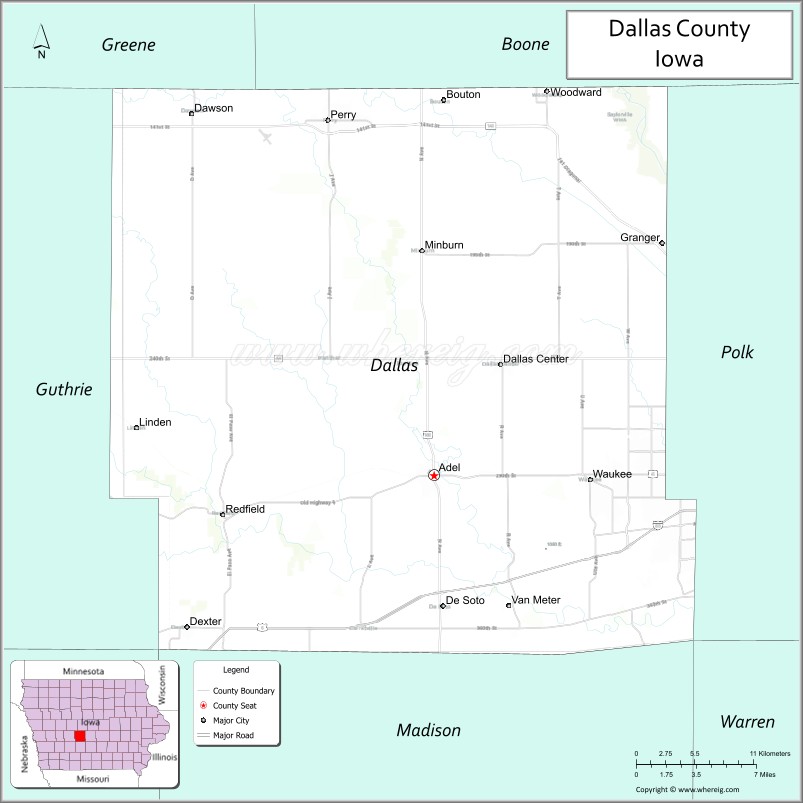
About Dallas County Map, Iowa: The map showing the county boundary, county seat, major cities, highways, water bodies and neighbouring counties.
More Iowa Maps & Info
| Iowa Map | Iowa County Map | Iowa Cities Map |
| Iowa Zip codes | Where is Iowa | Airports in Iowa |
| Iowa Area Codes | Iowa Blank Map | Iowa River Map |
| Iowa Physical Map | Iowa Road Map | Where is Des Moines |
Map of Dallas County, Iowa
Dallas County is a county located in the U.S. state of Iowa. It's county seat is Adel. As per 2020 census, the population of Dallas County is 103796 people and population density is square miles. According to the United States Census Bureau, the county has a total area of 586 sq mi (1,518 km2). Dallas County was established on -19709.
Dallas County Facts
| Continent | North America |
| Country | United States |
| State | Iowa |
| County Seat | Adel |
| Largest City/Town | Waukee |
| Established | January 13, 1846 |
| Total Area | 592 sq mi (1,533 sq km) |
| Land Area | 588 sq mi (1,523 sq km) |
| Water Area | 4 sq mi (10 sq km) |
| Population | 99,678 (Census 2020) |
| Population Density | 169.5 people per sq mi |
| Time Zone | Central Time Zone (CT) |
| Major Highways | Interstate 80, Interstate 35, U.S. Highway 6, U.S. Highway 169, Iowa Highway 44, Iowa Highway 141 |
| Major Rivers | Raccoon River, North Raccoon River, South Raccoon River |
| Neighboring Counties | Boone County, Polk County, Warren County, Madison County, Guthrie County, Greene County |
| Famous For | Rapid population growth, Waukee, suburban Des Moines communities, Raccoon River Valley Trail |
| Top Attractions | Raccoon River Valley Trail, Hanging Rock Park, Historic Adel Courthouse, Sugar Creek Golf Course |
| Official Website | Official Website |
About Dallas County, Iowa
Dallas County is located in central Iowa and was established in 1846. The county seat is Adel, while Waukee is the largest city. The county forms part of the Des Moines metropolitan area and has been one of the fastest-growing counties in the United States in recent decades. Dallas County combines rapidly expanding suburban communities with farmland, rivers, parks, and extensive recreational trails.
Cities and Towns in Dallas County, Iowa
| City/Town | Population (Census 2020) | Latitude & Longitude |
|---|---|---|
| Adel (county seat) | 6,153 | 41.6144°N, 94.0175°W |
| Waukee | 23,428 | 41.6111°N, 93.8852°W |
| Perry (part) | 7,836 | 41.8386°N, 94.1069°W |
| Grimes | 15,392 | 41.6883°N, 93.7911°W |
| West Des Moines (part) | 68,723 | 41.5772°N, 93.7113°W |
| Perry | 7,836 | 41.8386°N, 94.1069°W |
| Van Meter | 1,374 | 41.5325°N, 93.9544°W |
| Dallas Center | 1,945 | 41.6847°N, 93.9616°W |
| De Soto | 1,143 | 41.5317°N, 94.0094°W |
| Minburn | 338 | 41.7567°N, 94.0136°W |
| Dawson | 103 | 41.8425°N, 94.2186°W |
| Woodward | 1,346 | 41.8564°N, 93.9222°W |
| Redfield | 835 | 41.5900°N, 94.1964°W |
| Clive (part) | 18,601 | 41.6039°N, 93.7752°W |
| Urbandale (part) | 45,580 | 41.6267°N, 93.7122°W |
Best Golf Courses in Dallas County, Iowa
| Golf Course | Location | Latitude & Longitude |
|---|---|---|
| Sugar Creek Golf Course | Waukee | 41.6274°N, 93.8835°W |
| The Legacy Golf Club | Norwalk/Waukee Area | 41.5659°N, 93.8417°W |
| Des Moines Golf & Country Club | West Des Moines | 41.6176°N, 93.8073°W |
| River Valley Golf Course | Adel | 41.6088°N, 94.0306°W |
| Woodland Hills Golf Course | Desoto | 41.5329°N, 94.0198°W |
| Pheasant Ridge Golf Course | Cumming/West Des Moines Area | 41.4821°N, 93.7815°W |
| Beaver Creek Golf Club | Grimes | 41.7038°N, 93.7895°W |
| Lakeview Golf & Country Club | Panora Area | 41.6912°N, 94.3635°W |
What are Major Roads and Highways in Dallas County
Major highways connect the county to nearby regions and cities.
- Interstate 80 - major east-west interstate connecting Dallas County with Des Moines, Omaha, and eastern Iowa
- Interstate 35 - passes through eastern Dallas County and links central Iowa with Minnesota and Missouri
- U.S. Highway 6 - serves Waukee, Adel, and other communities across the county
- U.S. Highway 169 - north-south route connecting Dallas County with Boone County and Madison County
- Iowa Highway 44 - provides access to Dallas Center, Minburn, and surrounding rural areas
- Iowa Highway 141 - major commuter corridor connecting western suburbs to Des Moines
Neighboring Counties of Dallas County
- Boone County (north)
- Polk County (east)
- Warren County (southeast)
- Madison County (south)
- Guthrie County (west)
- Greene County (northwest)
What are Top Attractions in Dallas County, Iowa
The county offers a mix of natural and cultural attractions.
| Main Sight Name | City | Famous For |
|---|---|---|
| Raccoon River Valley Trail | Countywide | Popular paved trail for cycling, walking, and running |
| Historic Dallas County Courthouse | Adel | Beautiful nineteenth-century courthouse and landmark |
| Hanging Rock Park | Redfield | Unique limestone formations and scenic hiking |
| Kuehn Conservation Area | Earlham Area | Nature trails, wildlife viewing, and outdoor recreation |
| Brenton Arboretum | Dallas Center | Botanical collections and walking paths |
| Jordan Creek Town Center | West Des Moines | Major shopping and entertainment destination |
| Sugar Creek Golf Course | Waukee | Championship public golf facility |
| Adel Family Aquatic Center | Adel | Family recreation and seasonal water activities |
| Minburn Rail Trail Access | Minburn | Trailhead for outdoor recreation |
| Van Meter Visitor Center | Van Meter | Local history and tourism information |
| Dallas County Conservation Parks | Countywide | Camping, fishing, and outdoor activities |
| Raccoon River Corridor | Countywide | Scenic river landscapes and wildlife habitat |
Distance from Dallas County to Nearby Cities
The following distances are measured by road (driving).
- Adel to Waukee (Dallas County), Iowa - 10 mi (16 km)
- Adel to West Des Moines (Polk County), Iowa - 14 mi (23 km)
- Adel to Des Moines (Polk County), Iowa - 20 mi (32 km)
- Adel to Perry (Dallas County), Iowa - 23 mi (37 km)
- Adel to Boone (Boone County), Iowa - 29 mi (47 km)
- Adel to Indianola (Warren County), Iowa - 30 mi (48 km)
- Adel to Winterset (Madison County), Iowa - 20 mi (32 km)
- Adel to Guthrie Center (Guthrie County), Iowa - 28 mi (45 km)
- Adel to Jefferson (Greene County), Iowa - 40 mi (64 km)
- Adel to Ames (Story County), Iowa - 37 mi (60 km)
- Adel to Newton (Jasper County), Iowa - 49 mi (79 km)
- Adel to Marshalltown (Marshall County), Iowa - 67 mi (108 km)
- Adel to Fort Dodge (Webster County), Iowa - 74 mi (119 km)
- Adel to Council Bluffs (Pottawattamie County), Iowa - 113 mi (182 km)
- Adel to Omaha, Nebraska - 126 mi (203 km)
Nearest Airports
Nearest airport of Dallas is Des Moines International Airport (DSM / KDSM).
References
- QuickFacts - U.S. Census Bureau
- United States Census Bureau
- United States Geological Survey (USGS)
- National Geodetic Survey
- Official County Website
- Adair County Map
- Adams County Map
- Allamakee County Map
- Appanoose County Map
- Audubon County Map
- Benton County Map
- Black Hawk County Map
- Boone County Map
- Bremer County Map
- Buchanan County Map
- Buena Vista County Map
- Butler County Map
- Calhoun County Map
- Carroll County Map
- Cass County Map
- Cedar County Map
- Cerro Gordo County Map
- Cherokee County Map
- Chickasaw County Map
- Clarke County Map
- Clay County Map
- Clayton County Map
- Clinton County Map
- Crawford County Map
- Dallas County Map
- Davis County Map
- Decatur County Map
- Delaware County Map
- Des Moines County Map
- Dickinson County Map
- Dubuque County Map
- Emmet County Map
- Fayette County Map
- Floyd County Map
- Franklin County Map
- Fremont County Map
- Greene County Map
- Grundy County Map
- Guthrie County Map
- Hamilton County Map
- Hancock County Map
- Hardin County Map
- Harrison County Map
- Henry County Map
- Howard County Map
- Humboldt County Map
- Ida County Map
- Iowa County Map
- Jackson County Map
- Jasper County Map
- Jefferson County Map
- Johnson County Map
- Jones County Map
- Keokuk County Map
- Kossuth County Map
- Lee County Map
- Linn County Map
- Louisa County Map
- Lucas County Map
- Lyon County Map
- Madison County Map
- Mahaska County Map
- Marion County Map
- Marshall County Map
- Mills County Map
- Mitchell County Map
- Monona County Map
- Monroe County Map
- Montgomery County Map
- Muscatine County Map
- O'Brien County Map
- Osceola County Map
- Page County Map
- Palo Alto County Map
- Plymouth County Map
- Pocahontas County Map
- Polk County Map
- Pottawattamie County Map
- Poweshiek County Map
- Ringgold County Map
- Sac County Map
- Scott County Map
- Shelby County Map
- Sioux County Map
- Story County Map
- Tama County Map
- Taylor County Map
- Union County Map
- Van Buren County Map
- Wapello County Map
- Warren County Map
- Washington County Map
- Wayne County Map
- Webster County Map
- Winnebago County Map
- Winneshiek County Map
- Woodbury County Map
- Worth County Map
- Wright County Map
- Alabama Counties
- Alaska boroughs
- Arizona Counties
- Arkansas Counties
- California County Map
- Colorado Counties
- Connecticut Counties
- Delaware Counties
- Florida County Map
- Georgia County Map
- Hawaii Counties
- Idaho Counties
- Illinois Counties
- Indiana Counties
- Iowa Counties
- Kansas Counties
- Kentucky Counties
- Louisiana Counties
- Maine Counties
- Maryland Counties
- Massachusetts Counties
- Michigan County Map
- Minnesota Counties
- Mississippi Counties
- Missouri Counties
- Montana Counties
- Nebraska Counties
- Nevada Counties
- New York Counties
- New Hampshire Counties
- New Jersey Counties
- New Mexico Counties
- North Carolina Counties
- North Dakota Counties
- Ohio County Map
- Oklahoma Counties
- Oregon Counties
- Pennsylvania Counties
- Rhode Island Counties
- South Carolina Counties
- South Dakota Counties
- Map of Tennessee
- Texas County Map
- Utah Counties
- Vermont Counties
- Virginia Counties
- Washington Counties
- West Virginia Counties
- Wisconsin Counties
- Wyoming Counties