Written and Fact-checked by Whereig Editors | Last Updated On: June 10, 2026
Map of Emmet County - Emmet County is a county located in the U.S. state of Iowa. Emmet County Map showing cities, highways, important places and water bodies. Get Where is Emmet County located in the map, major cities in Emmet county, population, areas, and places of interest.
Emmet County Map, Iowa
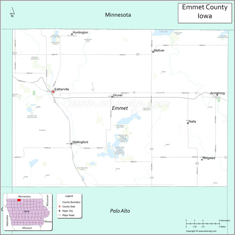
About Emmet County Map, Iowa: The map showing the county boundary, county seat, major cities, highways, water bodies and neighbouring counties.
More Iowa Maps & Info
| Iowa Map | Iowa County Map | Iowa Cities Map |
| Iowa Zip codes | Where is Iowa | Airports in Iowa |
| Iowa Area Codes | Iowa Blank Map | Iowa River Map |
| Iowa Physical Map | Iowa Road Map | Where is Des Moines |
Map of Emmet County, Iowa
Emmet County is a county located in the U.S. state of Iowa. It's county seat is Estherville. As per 2020 census, the population of Emmet County is 9321 people and population density is square miles. According to the United States Census Bureau, the county has a total area of 396 sq mi (1,026 km2). Emmet County was established on -17881.
Emmet County Facts
| Continent | North America |
| Country | United States |
| State | Iowa |
| County Seat | Estherville |
| Largest City/Town | Estherville |
| Established | January 15, 1851 |
| Total Area | 403 sq mi (1,044 sq km) |
| Land Area | 396 sq mi (1,026 sq km) |
| Water Area | 7 sq mi (18 sq km) |
| Population | 9,388 (Census 2020) |
| Population Density | 23.7 people per sq mi |
| Time Zone | Central Time Zone (CT) |
| Major Highways | U.S. Highway 4, Iowa Highway 9, Iowa Highway 15 |
| Major Rivers | Des Moines River, East Fork Des Moines River |
| Neighboring Counties | Jackson County (MN), Martin County (MN), Kossuth County, Palo Alto County, Dickinson County |
| Famous For | Estherville Meteorite, Iowa Lakes Community College, Fort Defiance State Park, glacial lakes |
| Top Attractions | Fort Defiance State Park, Estherville Meteorite Site, Swinging Bridge, Emmet County Nature Center |
| Official Website | Official Website |
About Emmet County, Iowa
Emmet County is located in north-central Iowa along the Minnesota border and was established in 1851. The county seat and largest city is Estherville. The county is known for its rich agricultural land, scenic river valleys, and the famous Estherville Meteorite that fell near the city in 1879. Emmet County also serves as an educational and recreational center for the surrounding region.
Cities and Towns in Emmet County, Iowa
| City/Town | Population (Census 2020) | Latitude & Longitude |
|---|---|---|
| Estherville (county seat) | 5,904 | 43.4011°N, 94.8322°W |
| Armstrong | 875 | 43.3964°N, 94.4789°W |
| Ringsted | 365 | 43.2977°N, 94.5144°W |
| Gruver | 94 | 43.3625°N, 94.6941°W |
| Dolliver | 66 | 43.4408°N, 94.6155°W |
| Wallingford | 189 | 43.3292°N, 94.7883°W |
Best Golf Courses in Emmet County, Iowa
| Golf Course | Location | Latitude & Longitude |
|---|---|---|
| Estherville Golf Course | Estherville | 43.4108°N, 94.8397°W |
| Gruver Golf & Recreation Club | Gruver | 43.3652°N, 94.6885°W |
| Five Island Golf Course | Estherville Area | 43.3975°N, 94.8452°W |
What are Major Roads and Highways in Emmet County
Major highways connect the county to nearby regions and cities.
- Iowa Highway 9 - east-west route connecting Estherville with Dickinson County and Kossuth County
- Iowa Highway 15 - north-south route linking Emmet County with Minnesota and southern Iowa communities
- U.S. Highway 4 - provides regional access through the eastern part of the county
Neighboring Counties of Emmet County
- Jackson County, Minnesota (northwest)
- Martin County, Minnesota (northeast)
- Kossuth County (east)
- Palo Alto County (south)
- Dickinson County (west)
What are Top Attractions in Emmet County, Iowa
The county offers a mix of natural and cultural attractions.
| Main Sight Name | City | Famous For |
|---|---|---|
| Fort Defiance State Park | Estherville | Hiking, camping, river views, and wildlife watching |
| Estherville Meteorite Site | Estherville | Location of the famous 1879 meteorite fall |
| Swinging Bridge | Estherville | Historic pedestrian bridge over the West Fork Des Moines River |
| Emmet County Nature Center | Estherville | Environmental education and nature exhibits |
| Santee Crossing | Estherville | Historic river crossing and recreation area |
| Iowa Lakes Community College Campus | Estherville | Educational institution and cultural events |
| Fort Defiance Lake | Estherville | Fishing, boating, and picnic facilities |
| High Lake | Wallingford | Fishing, wildlife viewing, and outdoor recreation |
| Tuttle Lake Recreation Area | Dolliver | Camping and lake recreation near the Minnesota border |
| Ringsted City Park | Ringsted | Community recreation and local events |
| Armstrong Heritage Museum | Armstrong | Local history and pioneer exhibits |
| Des Moines River Corridor | Countywide | Scenic landscapes and outdoor activities |
Distance from Emmet County to Nearby Cities
The following distances are measured by road (driving).
- Estherville to Spirit Lake (Dickinson County), Iowa - 18 mi (29 km)
- Estherville to Spencer (Clay County), Iowa - 32 mi (51 km)
- Estherville to Algona (Kossuth County), Iowa - 34 mi (55 km)
- Estherville to Emmetsburg (Palo Alto County), Iowa - 29 mi (47 km)
- Estherville to Fairmont, Minnesota - 21 mi (34 km)
- Estherville to Jackson, Minnesota - 34 mi (55 km)
- Estherville to Worthington, Minnesota - 53 mi (85 km)
- Estherville to Storm Lake (Buena Vista County), Iowa - 62 mi (100 km)
- Estherville to Fort Dodge (Webster County), Iowa - 86 mi (138 km)
- Estherville to Mason City (Cerro Gordo County), Iowa - 92 mi (148 km)
- Estherville to Sioux Falls, South Dakota - 105 mi (169 km)
- Estherville to Mankato, Minnesota - 88 mi (142 km)
- Estherville to Waterloo (Black Hawk County), Iowa - 145 mi (233 km)
- Estherville to Des Moines (Polk County), Iowa - 171 mi (275 km)
- Estherville to Minneapolis, Minnesota - 145 mi (233 km)
Nearest Airports
Nearest airport of Emmet is Estherville Muni Airport-Est.
References
- QuickFacts - U.S. Census Bureau
- United States Census Bureau
- United States Geological Survey (USGS)
- National Geodetic Survey
- Official County Website
- Adair County Map
- Adams County Map
- Allamakee County Map
- Appanoose County Map
- Audubon County Map
- Benton County Map
- Black Hawk County Map
- Boone County Map
- Bremer County Map
- Buchanan County Map
- Buena Vista County Map
- Butler County Map
- Calhoun County Map
- Carroll County Map
- Cass County Map
- Cedar County Map
- Cerro Gordo County Map
- Cherokee County Map
- Chickasaw County Map
- Clarke County Map
- Clay County Map
- Clayton County Map
- Clinton County Map
- Crawford County Map
- Dallas County Map
- Davis County Map
- Decatur County Map
- Delaware County Map
- Des Moines County Map
- Dickinson County Map
- Dubuque County Map
- Emmet County Map
- Fayette County Map
- Floyd County Map
- Franklin County Map
- Fremont County Map
- Greene County Map
- Grundy County Map
- Guthrie County Map
- Hamilton County Map
- Hancock County Map
- Hardin County Map
- Harrison County Map
- Henry County Map
- Howard County Map
- Humboldt County Map
- Ida County Map
- Iowa County Map
- Jackson County Map
- Jasper County Map
- Jefferson County Map
- Johnson County Map
- Jones County Map
- Keokuk County Map
- Kossuth County Map
- Lee County Map
- Linn County Map
- Louisa County Map
- Lucas County Map
- Lyon County Map
- Madison County Map
- Mahaska County Map
- Marion County Map
- Marshall County Map
- Mills County Map
- Mitchell County Map
- Monona County Map
- Monroe County Map
- Montgomery County Map
- Muscatine County Map
- O'Brien County Map
- Osceola County Map
- Page County Map
- Palo Alto County Map
- Plymouth County Map
- Pocahontas County Map
- Polk County Map
- Pottawattamie County Map
- Poweshiek County Map
- Ringgold County Map
- Sac County Map
- Scott County Map
- Shelby County Map
- Sioux County Map
- Story County Map
- Tama County Map
- Taylor County Map
- Union County Map
- Van Buren County Map
- Wapello County Map
- Warren County Map
- Washington County Map
- Wayne County Map
- Webster County Map
- Winnebago County Map
- Winneshiek County Map
- Woodbury County Map
- Worth County Map
- Wright County Map
- Alabama Counties
- Alaska boroughs
- Arizona Counties
- Arkansas Counties
- California County Map
- Colorado Counties
- Connecticut Counties
- Delaware Counties
- Florida County Map
- Georgia County Map
- Hawaii Counties
- Idaho Counties
- Illinois Counties
- Indiana Counties
- Iowa Counties
- Kansas Counties
- Kentucky Counties
- Louisiana Counties
- Maine Counties
- Maryland Counties
- Massachusetts Counties
- Michigan County Map
- Minnesota Counties
- Mississippi Counties
- Missouri Counties
- Montana Counties
- Nebraska Counties
- Nevada Counties
- New York Counties
- New Hampshire Counties
- New Jersey Counties
- New Mexico Counties
- North Carolina Counties
- North Dakota Counties
- Ohio County Map
- Oklahoma Counties
- Oregon Counties
- Pennsylvania Counties
- Rhode Island Counties
- South Carolina Counties
- South Dakota Counties
- Map of Tennessee
- Texas County Map
- Utah Counties
- Vermont Counties
- Virginia Counties
- Washington Counties
- West Virginia Counties
- Wisconsin Counties
- Wyoming Counties