Written and Fact-checked by Whereig Editors | Last Updated On: June 10, 2026
Map of Wright County - Wright County is a county located in the U.S. state of Iowa. Wright County Map showing cities, highways, important places and water bodies. Get Where is Wright County located in the map, major cities in Wright county, population, areas, and places of interest.
Wright County Map, Iowa
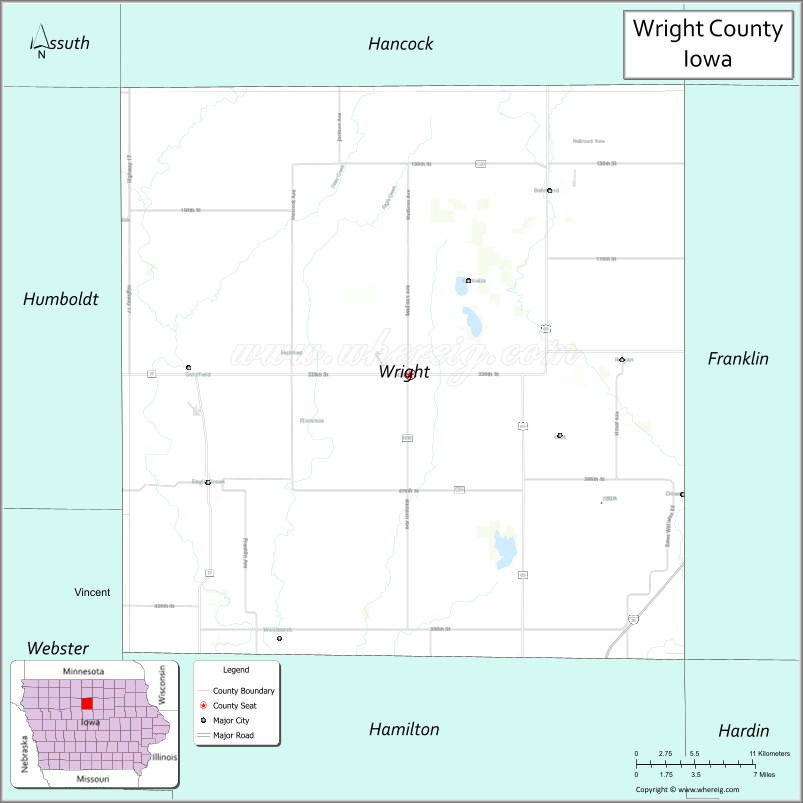
About Wright County Map, Iowa: The map showing the county boundary, county seat, major cities, highways, water bodies and neighbouring counties.
More Iowa Maps & Info
| Iowa Map | Iowa County Map | Iowa Cities Map |
| Iowa Zip codes | Where is Iowa | Airports in Iowa |
| Iowa Area Codes | Iowa Blank Map | Iowa River Map |
| Iowa Physical Map | Iowa Road Map | Where is Des Moines |
Map of Wright County, Iowa
Wright County is a county located in the U.S. state of Iowa. It's county seat is Clarion. As per 2020 census, the population of Wright County is 12785 people and population density is square miles. According to the United States Census Bureau, the county has a total area of 581 sq mi (1,505 km2). Wright County was established on -17881.
Wright County Facts
| Continent | North America |
| Country | United States |
| State | Iowa |
| County Seat | Clarion |
| Largest City/Town | Clarion |
| Established | January 15, 1851 |
| Total Area | 581 sq mi (1,505 sq km) |
| Land Area | 580 sq mi (1,502 sq km) |
| Water Area | 1 sq mi (3 sq km) |
| Population | 12,943 (Census 2020) |
| Population Density | 22.3 people per sq mi |
| Time Zone | Central Time Zone (CT) |
| Major Highways | Interstate 35, U.S. Highway 69, Iowa Highway 3, Iowa Highway 17 |
| Major Rivers | Boone River, Iowa River, Eagle Creek |
| Neighboring Counties | Hancock County, Franklin County, Hardin County, Hamilton County, Webster County, Humboldt County |
| Famous For | Clarion, Heartland Museum, agriculture, Interstate 35 corridor, prairie landscapes |
| Top Attractions | Heartland Museum, Lake Cornelia Park, Clarion Aquatic Center, Wright County Fairgrounds |
| Official Website | Official Website |
About Wright County, Iowa
Wright County is located in north-central Iowa and was established in 1851. The county seat and largest city is Clarion. Agriculture plays a central role in the county's economy, with corn, soybeans, and livestock production dominating the landscape. Wright County also benefits from its location along Interstate 35, which provides convenient access to major Iowa and Minnesota markets. The county is known for its strong rural communities, recreational parks, and local history.
Cities and Towns in Wright County, Iowa
| City/Town | Population (Census 2020) | Latitude & Longitude |
|---|---|---|
| Clarion (county seat) | 2,810 | 42.7311°N, 93.7327°W |
| Belmond | 2,376 | 42.8464°N, 93.6155°W |
| Eagle Grove | 3,602 | 42.6641°N, 93.9044°W |
| Dows | 538 | 42.6550°N, 93.5024°W |
| Galt | 28 | 42.7181°N, 93.6102°W |
| Rowan | 123 | 42.7511°N, 93.6255°W |
| Woolstock | 149 | 42.5728°N, 93.8436°W |
| Goldfield (partly) | 635 | 42.7331°N, 93.9208°W |
| Holmes (unincorporated) | 45 | 42.7811°N, 93.7250°W |
Best Golf Courses in Wright County, Iowa
| Golf Course | Location | Latitude & Longitude |
|---|---|---|
| Clarion Country Club | Clarion | 42.7247°N, 93.7444°W |
| Belmond Country Club | Belmond | 42.8489°N, 93.6278°W |
| Eagle Grove Golf Course | Eagle Grove | 42.6625°N, 93.9186°W |
| Lake Cornelia Recreation Golf Area | Clarion Area | 42.7497°N, 93.7128°W |
What are Major Roads and Highways in Wright County
Wright County is served by several major transportation routes that connect north-central Iowa with regional markets.
- Interstate 35 - major north-south interstate connecting Des Moines and Minneapolis
- U.S. Highway 69 - important route through Belmond and Clarion
- Iowa Highway 3 - major east-west highway across northern Iowa
- Iowa Highway 17 - regional north-south route serving western portions of the county
Neighboring Counties of Wright County
- Hancock County (north)
- Franklin County (east)
- Hardin County (southeast)
- Hamilton County (south)
- Webster County (southwest)
- Humboldt County (west)
What are Top Attractions in Wright County, Iowa
Wright County offers recreational facilities, historical attractions, and scenic outdoor destinations.
| Main Sight Name | City | Famous For |
|---|---|---|
| Heartland Museum | Clarion | Regional history, transportation, and agricultural exhibits |
| Lake Cornelia Park | Clarion | Camping, fishing, boating, and recreation |
| Clarion Aquatic Center | Clarion | Family recreation and summer activities |
| Belmond Historical Museum | Belmond | Community heritage and local history |
| Eagle Grove Historical Museum | Eagle Grove | Railroad history and local exhibits |
| Boone River Recreation Area | Countywide | Fishing, kayaking, and wildlife viewing |
| Dows Depot Welcome Center | Dows | Historic railroad depot and visitor information |
| Lake Cornelia Beach | Clarion Area | Swimming and outdoor recreation |
| Belmond Community Center | Belmond | Events and local gatherings |
| Wright County Fairgrounds | Eagle Grove | Agricultural fairs and annual celebrations |
| Prairie Heritage Scenic Drives | Countywide | Rural landscapes and photography opportunities |
| Clarion Historic Downtown | Clarion | Historic architecture and local businesses |
Distance from Wright County to Nearby Cities
The following distances are measured by road (driving) from Clarion.
- Clarion to Belmond (Wright County), Iowa - 11 mi (18 km)
- Clarion to Eagle Grove (Wright County), Iowa - 14 mi (23 km)
- Clarion to Dows (Wright County), Iowa - 12 mi (19 km)
- Clarion to Rowan (Wright County), Iowa - 7 mi (11 km)
- Clarion to Britt (Hancock County), Iowa - 19 mi (31 km)
- Clarion to Hampton (Franklin County), Iowa - 21 mi (34 km)
- Clarion to Eldora (Hardin County), Iowa - 38 mi (61 km)
- Clarion to Webster City (Hamilton County), Iowa - 28 mi (45 km)
- Clarion to Fort Dodge (Webster County), Iowa - 27 mi (43 km)
- Clarion to Humboldt (Humboldt County), Iowa - 30 mi (48 km)
- Clarion to Mason City (Cerro Gordo County), Iowa - 34 mi (55 km)
- Clarion to Ames (Story County), Iowa - 61 mi (98 km)
- Clarion to Des Moines (Polk County), Iowa - 95 mi (153 km)
- Clarion to Cedar Rapids (Linn County), Iowa - 130 mi (209 km)
- Clarion to Minneapolis, Minnesota - 151 mi (243 km)
Nearest Airports
Nearest airport of Wright is Cedar Rapids (CID) Airport.
References
- U.S. Census Bureau - Wright County QuickFacts
- Wright County Official Website
- City of Clarion
- United States Geological Survey (USGS)
- National Geodetic Survey (NGS)
- Adair County Map
- Adams County Map
- Allamakee County Map
- Appanoose County Map
- Audubon County Map
- Benton County Map
- Black Hawk County Map
- Boone County Map
- Bremer County Map
- Buchanan County Map
- Buena Vista County Map
- Butler County Map
- Calhoun County Map
- Carroll County Map
- Cass County Map
- Cedar County Map
- Cerro Gordo County Map
- Cherokee County Map
- Chickasaw County Map
- Clarke County Map
- Clay County Map
- Clayton County Map
- Clinton County Map
- Crawford County Map
- Dallas County Map
- Davis County Map
- Decatur County Map
- Delaware County Map
- Des Moines County Map
- Dickinson County Map
- Dubuque County Map
- Emmet County Map
- Fayette County Map
- Floyd County Map
- Franklin County Map
- Fremont County Map
- Greene County Map
- Grundy County Map
- Guthrie County Map
- Hamilton County Map
- Hancock County Map
- Hardin County Map
- Harrison County Map
- Henry County Map
- Howard County Map
- Humboldt County Map
- Ida County Map
- Iowa County Map
- Jackson County Map
- Jasper County Map
- Jefferson County Map
- Johnson County Map
- Jones County Map
- Keokuk County Map
- Kossuth County Map
- Lee County Map
- Linn County Map
- Louisa County Map
- Lucas County Map
- Lyon County Map
- Madison County Map
- Mahaska County Map
- Marion County Map
- Marshall County Map
- Mills County Map
- Mitchell County Map
- Monona County Map
- Monroe County Map
- Montgomery County Map
- Muscatine County Map
- O'Brien County Map
- Osceola County Map
- Page County Map
- Palo Alto County Map
- Plymouth County Map
- Pocahontas County Map
- Polk County Map
- Pottawattamie County Map
- Poweshiek County Map
- Ringgold County Map
- Sac County Map
- Scott County Map
- Shelby County Map
- Sioux County Map
- Story County Map
- Tama County Map
- Taylor County Map
- Union County Map
- Van Buren County Map
- Wapello County Map
- Warren County Map
- Washington County Map
- Wayne County Map
- Webster County Map
- Winnebago County Map
- Winneshiek County Map
- Woodbury County Map
- Worth County Map
- Wright County Map
- Alabama Counties
- Alaska boroughs
- Arizona Counties
- Arkansas Counties
- California County Map
- Colorado Counties
- Connecticut Counties
- Delaware Counties
- Florida County Map
- Georgia County Map
- Hawaii Counties
- Idaho Counties
- Illinois Counties
- Indiana Counties
- Iowa Counties
- Kansas Counties
- Kentucky Counties
- Louisiana Counties
- Maine Counties
- Maryland Counties
- Massachusetts Counties
- Michigan County Map
- Minnesota Counties
- Mississippi Counties
- Missouri Counties
- Montana Counties
- Nebraska Counties
- Nevada Counties
- New York Counties
- New Hampshire Counties
- New Jersey Counties
- New Mexico Counties
- North Carolina Counties
- North Dakota Counties
- Ohio County Map
- Oklahoma Counties
- Oregon Counties
- Pennsylvania Counties
- Rhode Island Counties
- South Carolina Counties
- South Dakota Counties
- Map of Tennessee
- Texas County Map
- Utah Counties
- Vermont Counties
- Virginia Counties
- Washington Counties
- West Virginia Counties
- Wisconsin Counties
- Wyoming Counties