Written and Fact-checked by Whereig Editors | Last Updated On: June 10, 2026
Map of Dickinson County - Dickinson County is a county located in the U.S. state of Iowa. Dickinson County Map showing cities, highways, important places and water bodies. Get Where is Dickinson County located in the map, major cities in Dickinson county, population, areas, and places of interest.
Dickinson County Map, Iowa
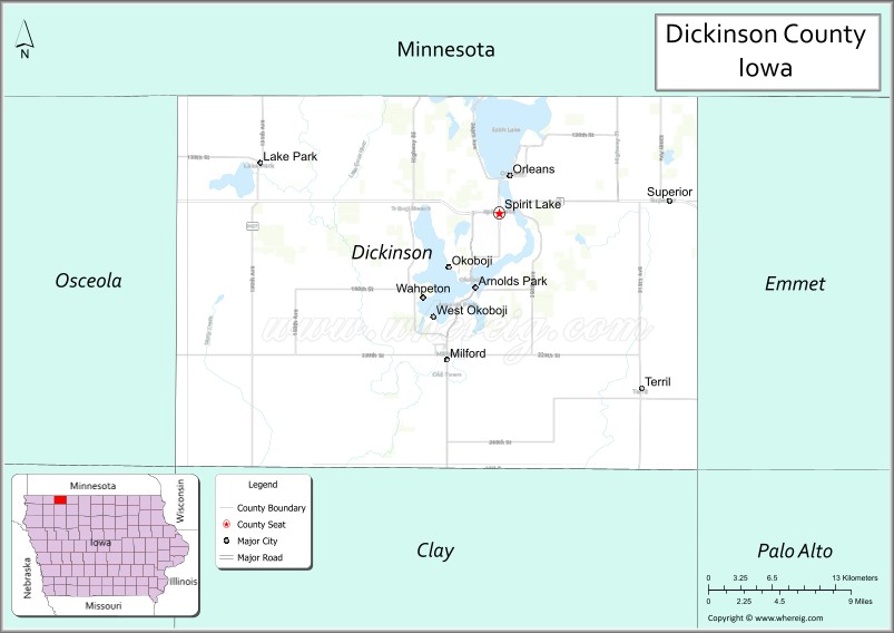
About Dickinson County Map, Iowa: The map showing the county boundary, county seat, major cities, highways, water bodies and neighbouring counties.
More Iowa Maps & Info
| Iowa Map | Iowa County Map | Iowa Cities Map |
| Iowa Zip codes | Where is Iowa | Airports in Iowa |
| Iowa Area Codes | Iowa Blank Map | Iowa River Map |
| Iowa Physical Map | Iowa Road Map | Where is Des Moines |
Map of Dickinson County, Iowa
Dickinson County is a county located in the U.S. state of Iowa. It's county seat is Spirit Lake. As per 2020 census, the population of Dickinson County is 17851 people and population density is square miles. According to the United States Census Bureau, the county has a total area of 381 sq mi (987 km2). Dickinson County was established on -17881.
Dickinson County Facts
| Continent | North America |
| Country | United States |
| State | Iowa |
| County Seat | Spirit Lake |
| Largest City/Town | Spirit Lake |
| Established | January 15, 1851 |
| Total Area | 404 sq mi (1,046 sq km) |
| Land Area | 381 sq mi (987 sq km) |
| Water Area | 23 sq mi (60 sq km) |
| Population | 17,703 (Census 2020) |
| Population Density | 46.5 people per sq mi |
| Time Zone | Central Time Zone (CT) |
| Major Highways | U.S. Highway 71, U.S. Highway 9, Iowa Highway 86 |
| Major Rivers | Little Sioux River, Milford Creek |
| Neighboring Counties | Jackson County (MN), Emmet County, Clay County, Osceola County |
| Famous For | Iowa Great Lakes, Okoboji tourism, boating, fishing, resorts, summer recreation |
| Top Attractions | West Okoboji Lake, Arnolds Park, Iowa Great Lakes Maritime Museum, Gull Point State Park |
| Official Website | Official Website |
About Dickinson County, Iowa
Dickinson County is located in northwestern Iowa along the Minnesota border and was established in 1851. The county seat is Spirit Lake, which is also the largest city. The county is home to the Iowa Great Lakes region, one of the Midwest's premier vacation destinations. Natural lakes, beaches, parks, resorts, and outdoor recreation opportunities attract visitors from across the United States throughout the year.
Cities and Towns in Dickinson County, Iowa
| City/Town | Population (Census 2020) | Latitude & Longitude |
|---|---|---|
| Spirit Lake (county seat) | 5,439 | 43.4211°N, 95.1022°W |
| Milford | 3,321 | 43.3247°N, 95.1505°W |
| Arnolds Park | 1,110 | 43.3636°N, 95.1278°W |
| Okoboji | 768 | 43.3864°N, 95.1464°W |
| Lake Park | 1,105 | 43.4544°N, 95.3216°W |
| Terril | 367 | 43.3044°N, 94.9736°W |
| Superior | 130 | 43.4014°N, 95.1794°W |
| Wahpeton | 345 | 43.3733°N, 95.1508°W |
| Orleans | 494 | 43.4436°N, 95.1092°W |
| West Okoboji | 287 | 43.3794°N, 95.1789°W |
Best Golf Courses in Dickinson County, Iowa
| Golf Course | Location | Latitude & Longitude |
|---|---|---|
| Brooks Golf Club | Okoboji | 43.3944°N, 95.1435°W |
| Emerald Hills Golf Club | Arnolds Park | 43.3697°N, 95.1194°W |
| Spencer Golf & Country Club | Spirit Lake Area | 43.4182°N, 95.0885°W |
| Indian Hills Golf Club | Spirit Lake | 43.4287°N, 95.0958°W |
| Okoboji View Golf Course | Spirit Lake | 43.4475°N, 95.0934°W |
| Pheasant Run Golf Course | Lake Park | 43.4591°N, 95.3178°W |
What are Major Roads and Highways in Dickinson County
Major highways connect the county to nearby regions and cities.
- U.S. Highway 71 - major north-south corridor connecting Spirit Lake, Arnolds Park, Milford, and Minnesota
- U.S. Highway 9 - east-west route linking Dickinson County with Emmet County, Osceola County, and regional destinations
- Iowa Highway 86 - scenic route serving the Iowa Great Lakes region and connecting major lake communities
Neighboring Counties of Dickinson County
- Jackson County, Minnesota (north)
- Emmet County (east)
- Clay County (south)
- Osceola County (west)
What are Top Attractions in Dickinson County, Iowa
The county offers a mix of natural and cultural attractions.
| Main Sight Name | City | Famous For |
|---|---|---|
| West Okoboji Lake | Okoboji | Crystal-clear waters, boating, and swimming |
| Arnolds Park Amusement Park | Arnolds Park | Historic amusement park and family entertainment |
| East Okoboji Lake | Spirit Lake | Fishing, boating, and waterfront recreation |
| Spirit Lake | Spirit Lake | Natural lake and outdoor recreation destination |
| Gull Point State Park | Milford | Camping, beaches, hiking, and lake access |
| Iowa Great Lakes Maritime Museum | Arnolds Park | Regional boating and maritime history |
| Pillsbury Point State Park | West Okoboji | Scenic lakefront camping and recreation |
| Kenue Park | Okoboji | Nature trails and outdoor recreation |
| Mini-Wakan State Park | Arnolds Park | Camping and lake views |
| Dickinson County Nature Center | Okoboji | Environmental education and wildlife exhibits |
| Abbie Gardner Cabin Museum | Arnolds Park | Historic Spirit Lake Massacre site |
| Elinor Bedell State Park | Spirit Lake | Lakeside recreation and wildlife habitat |
Distance from Dickinson County to Nearby Cities
The following distances are measured by road (driving).
- Spirit Lake to Milford (Dickinson County), Iowa - 7 mi (11 km)
- Spirit Lake to Arnolds Park (Dickinson County), Iowa - 4 mi (6 km)
- Spirit Lake to Spencer (Clay County), Iowa - 19 mi (31 km)
- Spirit Lake to Estherville (Emmet County), Iowa - 19 mi (31 km)
- Spirit Lake to Sibley (Osceola County), Iowa - 24 mi (39 km)
- Spirit Lake to Jackson, Minnesota - 31 mi (50 km)
- Spirit Lake to Worthington, Minnesota - 36 mi (58 km)
- Spirit Lake to Storm Lake (Buena Vista County), Iowa - 48 mi (77 km)
- Spirit Lake to Cherokee (Cherokee County), Iowa - 58 mi (93 km)
- Spirit Lake to Sioux City (Woodbury County), Iowa - 97 mi (156 km)
- Spirit Lake to Fort Dodge (Webster County), Iowa - 107 mi (172 km)
- Spirit Lake to Sioux Falls, South Dakota - 91 mi (146 km)
- Spirit Lake to Mankato, Minnesota - 118 mi (190 km)
- Spirit Lake to Des Moines (Polk County), Iowa - 192 mi (309 km)
- Spirit Lake to Minneapolis, Minnesota - 205 mi (330 km)
Nearest Airports
Nearest airport of Dickinson is Dickinson (DIK) Airport).
References
- QuickFacts - U.S. Census Bureau
- United States Census Bureau
- United States Geological Survey (USGS)
- National Geodetic Survey
- Official County Website
- Adair County Map
- Adams County Map
- Allamakee County Map
- Appanoose County Map
- Audubon County Map
- Benton County Map
- Black Hawk County Map
- Boone County Map
- Bremer County Map
- Buchanan County Map
- Buena Vista County Map
- Butler County Map
- Calhoun County Map
- Carroll County Map
- Cass County Map
- Cedar County Map
- Cerro Gordo County Map
- Cherokee County Map
- Chickasaw County Map
- Clarke County Map
- Clay County Map
- Clayton County Map
- Clinton County Map
- Crawford County Map
- Dallas County Map
- Davis County Map
- Decatur County Map
- Delaware County Map
- Des Moines County Map
- Dickinson County Map
- Dubuque County Map
- Emmet County Map
- Fayette County Map
- Floyd County Map
- Franklin County Map
- Fremont County Map
- Greene County Map
- Grundy County Map
- Guthrie County Map
- Hamilton County Map
- Hancock County Map
- Hardin County Map
- Harrison County Map
- Henry County Map
- Howard County Map
- Humboldt County Map
- Ida County Map
- Iowa County Map
- Jackson County Map
- Jasper County Map
- Jefferson County Map
- Johnson County Map
- Jones County Map
- Keokuk County Map
- Kossuth County Map
- Lee County Map
- Linn County Map
- Louisa County Map
- Lucas County Map
- Lyon County Map
- Madison County Map
- Mahaska County Map
- Marion County Map
- Marshall County Map
- Mills County Map
- Mitchell County Map
- Monona County Map
- Monroe County Map
- Montgomery County Map
- Muscatine County Map
- O'Brien County Map
- Osceola County Map
- Page County Map
- Palo Alto County Map
- Plymouth County Map
- Pocahontas County Map
- Polk County Map
- Pottawattamie County Map
- Poweshiek County Map
- Ringgold County Map
- Sac County Map
- Scott County Map
- Shelby County Map
- Sioux County Map
- Story County Map
- Tama County Map
- Taylor County Map
- Union County Map
- Van Buren County Map
- Wapello County Map
- Warren County Map
- Washington County Map
- Wayne County Map
- Webster County Map
- Winnebago County Map
- Winneshiek County Map
- Woodbury County Map
- Worth County Map
- Wright County Map
- Alabama Counties
- Alaska boroughs
- Arizona Counties
- Arkansas Counties
- California County Map
- Colorado Counties
- Connecticut Counties
- Delaware Counties
- Florida County Map
- Georgia County Map
- Hawaii Counties
- Idaho Counties
- Illinois Counties
- Indiana Counties
- Iowa Counties
- Kansas Counties
- Kentucky Counties
- Louisiana Counties
- Maine Counties
- Maryland Counties
- Massachusetts Counties
- Michigan County Map
- Minnesota Counties
- Mississippi Counties
- Missouri Counties
- Montana Counties
- Nebraska Counties
- Nevada Counties
- New York Counties
- New Hampshire Counties
- New Jersey Counties
- New Mexico Counties
- North Carolina Counties
- North Dakota Counties
- Ohio County Map
- Oklahoma Counties
- Oregon Counties
- Pennsylvania Counties
- Rhode Island Counties
- South Carolina Counties
- South Dakota Counties
- Map of Tennessee
- Texas County Map
- Utah Counties
- Vermont Counties
- Virginia Counties
- Washington Counties
- West Virginia Counties
- Wisconsin Counties
- Wyoming Counties