Written and Fact-checked by Whereig Editors | Last Updated On: June 10, 2026
Map of Floyd County - Floyd County is a county located in the U.S. state of Iowa. Floyd County Map showing cities, highways, important places and water bodies. Get Where is Floyd County located in the map, major cities in Floyd county, population, areas, and places of interest.
Floyd County Map, Iowa
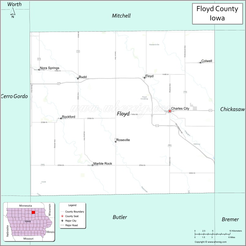
About Floyd County Map, Iowa: The map showing the county boundary, county seat, major cities, highways, water bodies and neighbouring counties.
More Iowa Maps & Info
| Iowa Map | Iowa County Map | Iowa Cities Map |
| Iowa Zip codes | Where is Iowa | Airports in Iowa |
| Iowa Area Codes | Iowa Blank Map | Iowa River Map |
| Iowa Physical Map | Iowa Road Map | Where is Des Moines |
Map of Floyd County, Iowa
Floyd County is a county located in the U.S. state of Iowa. It's county seat is Charles City. As per 2020 census, the population of Floyd County is 15413 people and population density is square miles. According to the United States Census Bureau, the county has a total area of 501 sq mi (1,298 km2). Floyd County was established on -17881.
Floyd County Facts
| Continent | North America |
| Country | United States |
| State | Iowa |
| County Seat | Charles City |
| Largest City/Town | Charles City |
| Established | January 15, 1851 |
| Total Area | 501 sq mi (1,298 sq km) |
| Land Area | 501 sq mi (1,298 sq km) |
| Water Area | 0.3 sq mi (0.8 sq km) |
| Population | 15,627 (Census 2020) |
| Population Density | 31.2 people per sq mi |
| Time Zone | Central Time Zone (CT) |
| Major Highways | U.S. Highway 18, U.S. Highway 218, Iowa Highway 14, Iowa Highway 27 (Avenue of the Saints) |
| Major Rivers | Cedar River, Shell Rock River |
| Neighboring Counties | Mitchell County, Chickasaw County, Butler County, Cerro Gordo County, Franklin County |
| Famous For | Charles City, Cedar River recreation, Carrie Chapman Catt birthplace region, agriculture and manufacturing |
| Top Attractions | Floyd County Museum, Charles City Whitewater Course, Cedar River Complex, Carrie Lane Chapman Catt Girlhood Home |
| Official Website | Official Website |
About Floyd County, Iowa
Floyd County is located in north-central Iowa and was established in 1851. The county seat and largest city is Charles City. The county lies along the Cedar River and is known for its agricultural heritage, outdoor recreation, and historic sites. Floyd County also played an important role in Iowa's industrial development and remains a regional center for manufacturing and community services.
Cities and Towns in Floyd County, Iowa
| City/Town | Population (Census 2020) | Latitude & Longitude |
|---|---|---|
| Charles City (county seat) | 7,396 | 43.0664°N, 92.6724°W |
| Nora Springs (part) | 1,431 | 43.1425°N, 93.0041°W |
| Colwell | 73 | 43.1572°N, 92.5935°W |
| Floyd | 313 | 43.1280°N, 92.7377°W |
| Marble Rock | 248 | 42.9645°N, 92.8691°W |
| Rockford | 758 | 43.0524°N, 92.9488°W |
| Rudd | 369 | 43.1288°N, 92.9027°W |
| Greene (part) | 1,099 | 42.8953°N, 92.8024°W |
| Bassett | 57 | 43.0697°N, 92.5549°W |
Best Golf Courses in Floyd County, Iowa
| Golf Course | Location | Latitude & Longitude |
|---|---|---|
| Wildwood Golf Course | Charles City | 43.0607°N, 92.6928°W |
| Cedar Bend Golf Course | Charles City | 43.0791°N, 92.6714°W |
| Rockford Country Club | Rockford | 43.0563°N, 92.9594°W |
| Nora Springs Golf Club | Nora Springs | 43.1468°N, 93.0087°W |
What are Major Roads and Highways in Floyd County
Major highways connect the county to nearby regions and cities.
- U.S. Highway 18 - major east-west route connecting Charles City with Mason City and New Hampton
- U.S. Highway 218 - important north-south corridor linking the county with Minnesota and eastern Iowa
- Iowa Highway 14 - serves central Floyd County and provides regional access
- Iowa Highway 27 (Avenue of the Saints) - major transportation corridor connecting northern and southern Iowa
Neighboring Counties of Floyd County
- Mitchell County (north)
- Chickasaw County (east)
- Butler County (south)
- Franklin County (southwest)
- Cerro Gordo County (west)
What are Top Attractions in Floyd County, Iowa
The county offers a mix of natural and cultural attractions.
| Main Sight Name | City | Famous For |
|---|---|---|
| Floyd County Museum | Charles City | Regional history exhibits and pioneer artifacts |
| Charles City Whitewater Course | Charles City | Kayaking, tubing, and river recreation |
| Cedar River Complex | Charles City | Riverfront trails, recreation, and scenic views |
| Carrie Lane Chapman Catt Girlhood Home | Charles City | Historic home of the women's suffrage leader |
| Central Park | Charles City | Community events and outdoor recreation |
| Wildwood Park | Charles City | Camping, trails, and nature activities |
| Fossil & Prairie Center | Rockford | Geological exhibits and educational programs |
| Marble Rock Historical District | Marble Rock | Historic buildings and local heritage |
| Nora Springs Trail System | Nora Springs | Walking, cycling, and outdoor recreation |
| Cedar River Greenbelt | Countywide | Fishing, canoeing, and wildlife viewing |
| Rudd Community Park | Rudd | Family recreation and local events |
| Floyd County Fairgrounds | Charles City | Agricultural fairs and community gatherings |
Distance from Floyd County to Nearby Cities
The following distances are measured by road (driving).
- Charles City to New Hampton (Chickasaw County), Iowa - 18 mi (29 km)
- Charles City to Osage (Mitchell County), Iowa - 25 mi (40 km)
- Charles City to Mason City (Cerro Gordo County), Iowa - 29 mi (47 km)
- Charles City to Hampton (Franklin County), Iowa - 33 mi (53 km)
- Charles City to Allison (Butler County), Iowa - 28 mi (45 km)
- Charles City to Waverly (Bremer County), Iowa - 36 mi (58 km)
- Charles City to Waterloo (Black Hawk County), Iowa - 49 mi (79 km)
- Charles City to Decorah (Winneshiek County), Iowa - 55 mi (89 km)
- Charles City to Clear Lake (Cerro Gordo County), Iowa - 35 mi (56 km)
- Charles City to Cedar Falls (Black Hawk County), Iowa - 53 mi (85 km)
- Charles City to Rochester, Minnesota - 72 mi (116 km)
- Charles City to Cedar Rapids (Linn County), Iowa - 92 mi (148 km)
- Charles City to Des Moines (Polk County), Iowa - 138 mi (222 km)
- Charles City to Minneapolis, Minnesota - 152 mi (245 km)
- Charles City to Madison (Dane County), Wisconsin - 181 mi (291 km)
Nearest Airports
Nearest airport of Floyd is Waterloo Regional Airport (ALO / KALO).
References
- QuickFacts - U.S. Census Bureau
- United States Census Bureau
- United States Geological Survey (USGS)
- National Geodetic Survey
- Official County Website
- Adair County Map
- Adams County Map
- Allamakee County Map
- Appanoose County Map
- Audubon County Map
- Benton County Map
- Black Hawk County Map
- Boone County Map
- Bremer County Map
- Buchanan County Map
- Buena Vista County Map
- Butler County Map
- Calhoun County Map
- Carroll County Map
- Cass County Map
- Cedar County Map
- Cerro Gordo County Map
- Cherokee County Map
- Chickasaw County Map
- Clarke County Map
- Clay County Map
- Clayton County Map
- Clinton County Map
- Crawford County Map
- Dallas County Map
- Davis County Map
- Decatur County Map
- Delaware County Map
- Des Moines County Map
- Dickinson County Map
- Dubuque County Map
- Emmet County Map
- Fayette County Map
- Floyd County Map
- Franklin County Map
- Fremont County Map
- Greene County Map
- Grundy County Map
- Guthrie County Map
- Hamilton County Map
- Hancock County Map
- Hardin County Map
- Harrison County Map
- Henry County Map
- Howard County Map
- Humboldt County Map
- Ida County Map
- Iowa County Map
- Jackson County Map
- Jasper County Map
- Jefferson County Map
- Johnson County Map
- Jones County Map
- Keokuk County Map
- Kossuth County Map
- Lee County Map
- Linn County Map
- Louisa County Map
- Lucas County Map
- Lyon County Map
- Madison County Map
- Mahaska County Map
- Marion County Map
- Marshall County Map
- Mills County Map
- Mitchell County Map
- Monona County Map
- Monroe County Map
- Montgomery County Map
- Muscatine County Map
- O'Brien County Map
- Osceola County Map
- Page County Map
- Palo Alto County Map
- Plymouth County Map
- Pocahontas County Map
- Polk County Map
- Pottawattamie County Map
- Poweshiek County Map
- Ringgold County Map
- Sac County Map
- Scott County Map
- Shelby County Map
- Sioux County Map
- Story County Map
- Tama County Map
- Taylor County Map
- Union County Map
- Van Buren County Map
- Wapello County Map
- Warren County Map
- Washington County Map
- Wayne County Map
- Webster County Map
- Winnebago County Map
- Winneshiek County Map
- Woodbury County Map
- Worth County Map
- Wright County Map
- Alabama Counties
- Alaska boroughs
- Arizona Counties
- Arkansas Counties
- California County Map
- Colorado Counties
- Connecticut Counties
- Delaware Counties
- Florida County Map
- Georgia County Map
- Hawaii Counties
- Idaho Counties
- Illinois Counties
- Indiana Counties
- Iowa Counties
- Kansas Counties
- Kentucky Counties
- Louisiana Counties
- Maine Counties
- Maryland Counties
- Massachusetts Counties
- Michigan County Map
- Minnesota Counties
- Mississippi Counties
- Missouri Counties
- Montana Counties
- Nebraska Counties
- Nevada Counties
- New York Counties
- New Hampshire Counties
- New Jersey Counties
- New Mexico Counties
- North Carolina Counties
- North Dakota Counties
- Ohio County Map
- Oklahoma Counties
- Oregon Counties
- Pennsylvania Counties
- Rhode Island Counties
- South Carolina Counties
- South Dakota Counties
- Map of Tennessee
- Texas County Map
- Utah Counties
- Vermont Counties
- Virginia Counties
- Washington Counties
- West Virginia Counties
- Wisconsin Counties
- Wyoming Counties