Written and Fact-checked by Whereig Editors | Last Updated On: June 10, 2026
Map of Audubon County - Audubon County is a county located in the U.S. state of Iowa. Audubon County Map showing cities, highways, important places and water bodies. Get Where is Audubon County located in the map, major cities in Audubon county, population, areas, and places of interest.
Audubon County Map, Iowa
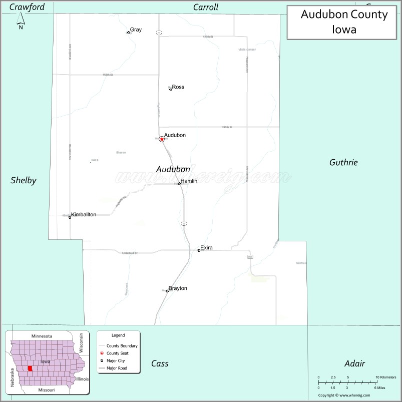
About Audubon County Map, Iowa: The map showing the county boundary, county seat, major cities, highways, water bodies and neighbouring counties.
More Iowa Maps & Info
| Iowa Map | Iowa County Map | Iowa Cities Map |
| Iowa Zip codes | Where is Iowa | Airports in Iowa |
| Iowa Area Codes | Iowa Blank Map | Iowa River Map |
| Iowa Physical Map | Iowa Road Map | Where is Des Moines |
Map of Audubon County, Iowa
Audubon County is a county located in the U.S. state of Iowa. It's county seat is Audubon. As per 2020 census, the population of Audubon County is 5635 people and population density is square miles. According to the United States Census Bureau, the county has a total area of 443 sq mi (1,147 km2). Audubon County was established on -17881.
Audubon County Facts
| Continent | North America |
| Country | United States |
| State | Iowa |
| County Seat | Audubon |
| Largest City/Town | Audubon |
| Established | 1851 |
| Total Area | 443 sq mi (1,147 sq km) |
| Land Area | 443 sq mi (1,147 sq km) |
| Water Area | 0.3 sq mi (1 sq km) |
| Population | 5,674 (Census 2020) |
| Population Density | 12.8 people per sq mi |
| Time Zone | Central Time Zone (CT) |
| Major Highways | U.S. Highway 71, Iowa Highway 44, Iowa Highway 173 |
| Major Rivers | East Nishnabotna River, West Nishnabotna River, Davids Creek |
| Neighboring Counties | Carroll County, Guthrie County, Cass County, Shelby County, Crawford County |
| Famous For | Danish heritage, Albert the Bull, rolling farmland, Audubon County Park |
| Top Attractions | Albert the Bull, Audubon County Park, Littlefield Recreation Area, Danish Windmill connections |
| Official Website | Official Website |
About Audubon County, Iowa
Audubon County is located in west-central Iowa and was established in 1851. The county seat is Audubon, which is also the largest city. The county is characterized by gently rolling farmland, scenic river valleys, and strong agricultural traditions. Named after naturalist John James Audubon, the county is known for its rural landscapes and welcoming small-town communities.
Cities and Towns in Audubon County, Iowa
| City/Town | Population (Census 2020) | Latitude & Longitude |
|---|---|---|
| Audubon (county seat) | 1,682 | 41.7203°N, 94.9327°W |
| Exira | 787 | 41.5917°N, 94.8794°W |
| Kimballton | 291 | 41.6299°N, 95.0730°W |
| Elk Horn | 601 | 41.5910°N, 95.0608°W |
| Gray | 61 | 41.8410°N, 94.8174°W |
| Hamlin | 75 | 41.6589°N, 94.8769°W |
| Brayton | 128 | 41.5456°N, 94.9336°W |
Best Golf Courses in Audubon County, Iowa
| Golf Course | Location | Latitude & Longitude |
|---|---|---|
| Audubon Golf & Country Club | Audubon | 41.7185°N, 94.9497°W |
| Camblin Hills Golf Course | Hamlin | 41.6464°N, 94.8615°W |
What are Major Roads and Highways in Audubon County
Major highways connect the county to nearby regions and cities.
- U.S. Highway 71 - north-south route connecting Audubon with Carroll, Atlantic and communities across western Iowa
- Iowa Highway 44 - east-west route linking Audubon with Guthrie Center, Harlan and surrounding counties
- Iowa Highway 173 - serves local traffic between Elk Horn, Kimballton and neighboring communities
- County Road N28 - important agricultural route through central portions of the county
- County Road F58 - provides access to rural townships and recreation areas
Neighboring Counties of Audubon County
- Carroll County (north)
- Guthrie County (east)
- Cass County (south)
- Shelby County (west)
- Crawford County (northwest)
What are Top Attractions in Audubon County, Iowa
The county offers a mix of natural and cultural attractions.
| Main Sight Name | City | Famous For |
|---|---|---|
| Albert the Bull | Audubon | Famous giant bull statue and roadside landmark |
| Audubon County Park | Audubon | Camping, hiking, fishing and family recreation |
| Littlefield Recreation Area | Audubon | Lake activities, camping and wildlife viewing |
| Danish Immigrant Museum | Elk Horn | Danish-American heritage exhibits |
| Danish Windmill | Elk Horn | Authentic Danish windmill and cultural landmark |
| Kimballton Town Square | Kimballton | Historic Danish-American community center |
| Audubon County Historical Society Museum | Audubon | Local history and pioneer exhibits |
| T-Bone Trail Access | Audubon | Walking and cycling recreation |
| Hamlin Community Area | Hamlin | Small-town Iowa scenery and local events |
| Exira City Park | Exira | Community recreation and outdoor activities |
Distance from Audubon County to Nearby Cities
The following distances are measured by road (driving).
- Audubon to Atlantic (Cass County), Iowa - 22 mi (35 km)
- Audubon to Harlan (Shelby County), Iowa - 24 mi (39 km)
- Audubon to Carroll (Carroll County), Iowa - 29 mi (47 km)
- Audubon to Guthrie Center (Guthrie County), Iowa - 29 mi (47 km)
- Audubon to Denison (Crawford County), Iowa - 34 mi (55 km)
- Audubon to Perry (Dallas County), Iowa - 47 mi (76 km)
- Audubon to Creston (Union County), Iowa - 52 mi (84 km)
- Audubon to Council Bluffs (Pottawattamie County), Iowa - 60 mi (97 km)
- Audubon to Ames (Story County), Iowa - 74 mi (119 km)
- Audubon to Omaha, Nebraska - 69 mi (111 km)
- Audubon to Des Moines (Polk County), Iowa - 77 mi (124 km)
- Audubon to Fort Dodge (Webster County), Iowa - 91 mi (146 km)
- Audubon to Sioux City (Woodbury County), Iowa - 106 mi (171 km)
- Audubon to Waterloo (Black Hawk County), Iowa - 134 mi (216 km)
- Audubon to Kansas City, Missouri - 178 mi (286 km)
Nearest Airports
Nearest airport of Audubon is Audubon County Airport.
References
- QuickFacts - U.S. Census Bureau
- United States Census Bureau
- United States Geological Survey (USGS)
- National Geodetic Survey
- Official County Website
- Adair County Map
- Adams County Map
- Allamakee County Map
- Appanoose County Map
- Audubon County Map
- Benton County Map
- Black Hawk County Map
- Boone County Map
- Bremer County Map
- Buchanan County Map
- Buena Vista County Map
- Butler County Map
- Calhoun County Map
- Carroll County Map
- Cass County Map
- Cedar County Map
- Cerro Gordo County Map
- Cherokee County Map
- Chickasaw County Map
- Clarke County Map
- Clay County Map
- Clayton County Map
- Clinton County Map
- Crawford County Map
- Dallas County Map
- Davis County Map
- Decatur County Map
- Delaware County Map
- Des Moines County Map
- Dickinson County Map
- Dubuque County Map
- Emmet County Map
- Fayette County Map
- Floyd County Map
- Franklin County Map
- Fremont County Map
- Greene County Map
- Grundy County Map
- Guthrie County Map
- Hamilton County Map
- Hancock County Map
- Hardin County Map
- Harrison County Map
- Henry County Map
- Howard County Map
- Humboldt County Map
- Ida County Map
- Iowa County Map
- Jackson County Map
- Jasper County Map
- Jefferson County Map
- Johnson County Map
- Jones County Map
- Keokuk County Map
- Kossuth County Map
- Lee County Map
- Linn County Map
- Louisa County Map
- Lucas County Map
- Lyon County Map
- Madison County Map
- Mahaska County Map
- Marion County Map
- Marshall County Map
- Mills County Map
- Mitchell County Map
- Monona County Map
- Monroe County Map
- Montgomery County Map
- Muscatine County Map
- O'Brien County Map
- Osceola County Map
- Page County Map
- Palo Alto County Map
- Plymouth County Map
- Pocahontas County Map
- Polk County Map
- Pottawattamie County Map
- Poweshiek County Map
- Ringgold County Map
- Sac County Map
- Scott County Map
- Shelby County Map
- Sioux County Map
- Story County Map
- Tama County Map
- Taylor County Map
- Union County Map
- Van Buren County Map
- Wapello County Map
- Warren County Map
- Washington County Map
- Wayne County Map
- Webster County Map
- Winnebago County Map
- Winneshiek County Map
- Woodbury County Map
- Worth County Map
- Wright County Map
- Alabama Counties
- Alaska boroughs
- Arizona Counties
- Arkansas Counties
- California County Map
- Colorado Counties
- Connecticut Counties
- Delaware Counties
- Florida County Map
- Georgia County Map
- Hawaii Counties
- Idaho Counties
- Illinois Counties
- Indiana Counties
- Iowa Counties
- Kansas Counties
- Kentucky Counties
- Louisiana Counties
- Maine Counties
- Maryland Counties
- Massachusetts Counties
- Michigan County Map
- Minnesota Counties
- Mississippi Counties
- Missouri Counties
- Montana Counties
- Nebraska Counties
- Nevada Counties
- New York Counties
- New Hampshire Counties
- New Jersey Counties
- New Mexico Counties
- North Carolina Counties
- North Dakota Counties
- Ohio County Map
- Oklahoma Counties
- Oregon Counties
- Pennsylvania Counties
- Rhode Island Counties
- South Carolina Counties
- South Dakota Counties
- Map of Tennessee
- Texas County Map
- Utah Counties
- Vermont Counties
- Virginia Counties
- Washington Counties
- West Virginia Counties
- Wisconsin Counties
- Wyoming Counties