Written and Fact-checked by Whereig Editors | Last Updated On: June 10, 2026
Map of Van Buren County - Van Buren County is a county located in the U.S. state of Iowa. Van Buren County Map showing cities, highways, important places and water bodies. Get Where is Van Buren County located in the map, major cities in Van Buren county, population, areas, and places of interest.
Van Buren County Map, Iowa
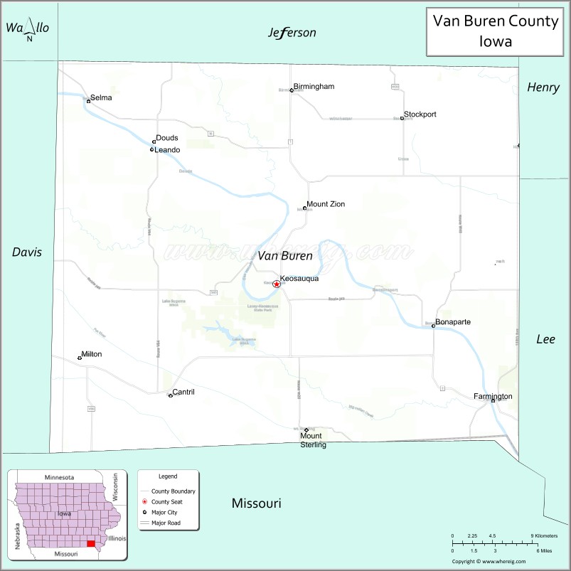
About Van Buren County Map, Iowa: The map showing the county boundary, county seat, major cities, highways, water bodies and neighbouring counties.
More Iowa Maps & Info
| Iowa Map | Iowa County Map | Iowa Cities Map |
| Iowa Zip codes | Where is Iowa | Airports in Iowa |
| Iowa Area Codes | Iowa Blank Map | Iowa River Map |
| Iowa Physical Map | Iowa Road Map | Where is Des Moines |
Map of Van Buren County, Iowa
Van Buren County is a county located in the U.S. state of Iowa. It's county seat is Keosauqua. As per 2020 census, the population of Van Buren County is 7243 people and population density is square miles. According to the United States Census Bureau, the county has a total area of 485 sq mi (1,256 km2). Van Buren County was established on -23033.
Van Buren County Facts
| Continent | North America |
| Country | United States |
| State | Iowa |
| County Seat | Keosauqua |
| Largest City/Town | Keosauqua |
| Established | December 7, 1836 |
| Total Area | 485 sq mi (1,256 sq km) |
| Land Area | 484 sq mi (1,254 sq km) |
| Water Area | 1 sq mi (2 sq km) |
| Population | 6,973 (Census 2020) |
| Population Density | 14.4 people per sq mi |
| Time Zone | Central Time Zone (CT) |
| Major Highways | Iowa Highway 1, Iowa Highway 2, Iowa Highway 16 |
| Major Rivers | Des Moines River, Fox River, Indian Creek |
| Neighboring Counties | Jefferson County, Henry County, Lee County, Davis County, Wapello County, Clark County (MO), Scotland County (MO) |
| Famous For | Villages of Van Buren, historic river towns, covered bridges, Des Moines River Valley, scenic byways |
| Top Attractions | Lacey-Keosauqua State Park, Bentonsport Historic District, Villages of Van Buren, Bonaparte Historic Riverfront |
| Official Website | Official Website |
About Van Buren County, Iowa
Van Buren County is located in southeastern Iowa along the Des Moines River and was established in 1836, making it one of Iowa's oldest counties. The county seat and largest community is Keosauqua. Named after President Martin Van Buren, the county is known for its historic river towns, covered bridges, scenic landscapes, and the nationally recognized Villages of Van Buren tourism region. Agriculture, tourism, and small businesses contribute significantly to the local economy.
Cities and Towns in Van Buren County, Iowa
| City/Town | Population (Census 2020) | Latitude & Longitude |
|---|---|---|
| Keosauqua (county seat) | 936 | 40.7306°N, 91.9621°W |
| Bonaparte | 381 | 40.6989°N, 91.8013°W |
| Birmingham | 423 | 40.8794°N, 91.9502°W |
| Cantril | 222 | 40.6414°N, 92.0677°W |
| Douds | 152 | 40.8250°N, 92.0702°W |
| Farmington | 664 | 40.6400°N, 91.7421°W |
| Hillsboro | 184 | 40.8356°N, 91.7158°W |
| Milton | 443 | 40.6689°N, 92.1613°W |
| Morrison | 94 | 40.9781°N, 91.9897°W |
| Selma | 85 | 40.8553°N, 92.0311°W |
| Stockport | 284 | 40.8575°N, 91.8338°W |
| Bentonsport (unincorporated) | 40 | 40.7269°N, 91.8530°W |
Best Golf Courses in Van Buren County, Iowa
| Golf Course | Location | Latitude & Longitude |
|---|---|---|
| Riverview Club | Keosauqua | 40.7358°N, 91.9753°W |
| Farmington Golf & Country Club | Farmington | 40.6447°N, 91.7508°W |
| Bonaparte Community Golf Course | Bonaparte | 40.7036°N, 91.8128°W |
What are Major Roads and Highways in Van Buren County
Several state highways connect Van Buren County with neighboring communities across southeastern Iowa.
- Iowa Highway 1 - major north-south route through the county
- Iowa Highway 2 - east-west highway across southern Iowa
- Iowa Highway 16 - scenic route connecting communities along the Des Moines River Valley
Neighboring Counties of Van Buren County
- Jefferson County (north)
- Henry County (northeast)
- Lee County (east)
- Davis County (west)
- Wapello County (northwest)
- Clark County, Missouri (south)
- Scotland County, Missouri (southeast)
What are Top Attractions in Van Buren County, Iowa
Van Buren County is one of Iowa's leading heritage tourism destinations and offers numerous historic and outdoor attractions.
| Main Sight Name | City | Famous For |
|---|---|---|
| Lacey-Keosauqua State Park | Keosauqua | Hiking, camping, fishing, and scenic river views |
| Bentonsport Historic District | Bentonsport | Historic river village with restored nineteenth-century buildings |
| Bonaparte Historic Riverfront | Bonaparte | Historic mills, riverfront scenery, and shops |
| Villages of Van Buren | Countywide | Collection of historic villages and cultural attractions |
| Keosauqua Pedestrian Bridge | Keosauqua | Historic suspension bridge across the Des Moines River |
| Van Buren County Courthouse | Keosauqua | Historic county courthouse architecture |
| Farmington Strawberry Festival | Farmington | Annual community celebration and events |
| Mason House Inn | Bentonsport | Historic hotel and reputed haunted landmark |
| Indian Artifact Museum | Keosauqua | Native American artifacts and regional history |
| Des Moines River Scenic Corridor | Countywide | Fishing, boating, wildlife viewing, and photography |
| Stockport Historic District | Stockport | Historic downtown and local heritage |
| Van Buren County Fairgrounds | Keosauqua | Agricultural fairs and annual community events |
Distance from Van Buren County to Nearby Cities
The following distances are measured by road (driving) from Keosauqua.
- Keosauqua to Bonaparte (Van Buren County), Iowa - 11 mi (18 km)
- Keosauqua to Farmington (Van Buren County), Iowa - 15 mi (24 km)
- Keosauqua to Birmingham (Van Buren County), Iowa - 11 mi (18 km)
- Keosauqua to Milton (Van Buren County), Iowa - 13 mi (21 km)
- Keosauqua to Fairfield (Jefferson County), Iowa - 20 mi (32 km)
- Keosauqua to Mount Pleasant (Henry County), Iowa - 33 mi (53 km)
- Keosauqua to Fort Madison (Lee County), Iowa - 39 mi (63 km)
- Keosauqua to Bloomfield (Davis County), Iowa - 22 mi (35 km)
- Keosauqua to Ottumwa (Wapello County), Iowa - 34 mi (55 km)
- Keosauqua to Memphis, Missouri - 27 mi (43 km)
- Keosauqua to Kirksville, Missouri - 53 mi (85 km)
- Keosauqua to Burlington (Des Moines County), Iowa - 47 mi (76 km)
- Keosauqua to Iowa City (Johnson County), Iowa - 79 mi (127 km)
- Keosauqua to Cedar Rapids (Linn County), Iowa - 108 mi (174 km)
- Keosauqua to Des Moines (Polk County), Iowa - 114 mi (183 km)
Nearest Airports
Nearest airport of Van Buren is Fort Smith (FSM) Airport.
References
- U.S. Census Bureau - Van Buren County QuickFacts
- Van Buren County Official Website
- Villages of Van Buren Tourism
- United States Geological Survey (USGS)
- National Geodetic Survey (NGS)
- Adair County Map
- Adams County Map
- Allamakee County Map
- Appanoose County Map
- Audubon County Map
- Benton County Map
- Black Hawk County Map
- Boone County Map
- Bremer County Map
- Buchanan County Map
- Buena Vista County Map
- Butler County Map
- Calhoun County Map
- Carroll County Map
- Cass County Map
- Cedar County Map
- Cerro Gordo County Map
- Cherokee County Map
- Chickasaw County Map
- Clarke County Map
- Clay County Map
- Clayton County Map
- Clinton County Map
- Crawford County Map
- Dallas County Map
- Davis County Map
- Decatur County Map
- Delaware County Map
- Des Moines County Map
- Dickinson County Map
- Dubuque County Map
- Emmet County Map
- Fayette County Map
- Floyd County Map
- Franklin County Map
- Fremont County Map
- Greene County Map
- Grundy County Map
- Guthrie County Map
- Hamilton County Map
- Hancock County Map
- Hardin County Map
- Harrison County Map
- Henry County Map
- Howard County Map
- Humboldt County Map
- Ida County Map
- Iowa County Map
- Jackson County Map
- Jasper County Map
- Jefferson County Map
- Johnson County Map
- Jones County Map
- Keokuk County Map
- Kossuth County Map
- Lee County Map
- Linn County Map
- Louisa County Map
- Lucas County Map
- Lyon County Map
- Madison County Map
- Mahaska County Map
- Marion County Map
- Marshall County Map
- Mills County Map
- Mitchell County Map
- Monona County Map
- Monroe County Map
- Montgomery County Map
- Muscatine County Map
- O'Brien County Map
- Osceola County Map
- Page County Map
- Palo Alto County Map
- Plymouth County Map
- Pocahontas County Map
- Polk County Map
- Pottawattamie County Map
- Poweshiek County Map
- Ringgold County Map
- Sac County Map
- Scott County Map
- Shelby County Map
- Sioux County Map
- Story County Map
- Tama County Map
- Taylor County Map
- Union County Map
- Van Buren County Map
- Wapello County Map
- Warren County Map
- Washington County Map
- Wayne County Map
- Webster County Map
- Winnebago County Map
- Winneshiek County Map
- Woodbury County Map
- Worth County Map
- Wright County Map
- Alabama Counties
- Alaska boroughs
- Arizona Counties
- Arkansas Counties
- California County Map
- Colorado Counties
- Connecticut Counties
- Delaware Counties
- Florida County Map
- Georgia County Map
- Hawaii Counties
- Idaho Counties
- Illinois Counties
- Indiana Counties
- Iowa Counties
- Kansas Counties
- Kentucky Counties
- Louisiana Counties
- Maine Counties
- Maryland Counties
- Massachusetts Counties
- Michigan County Map
- Minnesota Counties
- Mississippi Counties
- Missouri Counties
- Montana Counties
- Nebraska Counties
- Nevada Counties
- New York Counties
- New Hampshire Counties
- New Jersey Counties
- New Mexico Counties
- North Carolina Counties
- North Dakota Counties
- Ohio County Map
- Oklahoma Counties
- Oregon Counties
- Pennsylvania Counties
- Rhode Island Counties
- South Carolina Counties
- South Dakota Counties
- Map of Tennessee
- Texas County Map
- Utah Counties
- Vermont Counties
- Virginia Counties
- Washington Counties
- West Virginia Counties
- Wisconsin Counties
- Wyoming Counties