Written and Fact-checked by Whereig Editors | Last Updated On: June 10, 2026
Map of Wapello County - Wapello County is a county located in the U.S. state of Iowa. Wapello County Map showing cities, highways, important places and water bodies. Get Where is Wapello County located in the map, major cities in Wapello county, population, areas, and places of interest.
Wapello County Map, Iowa
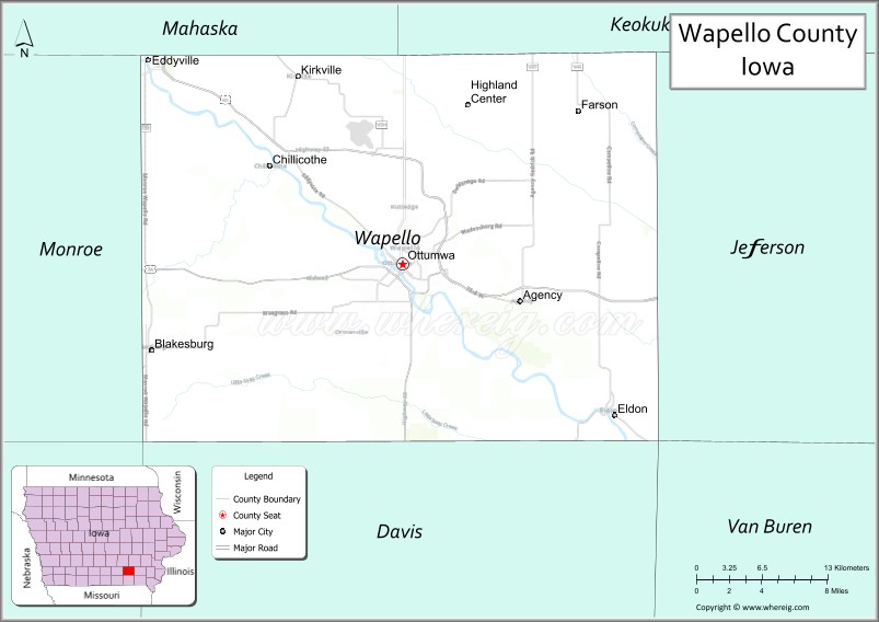
About Wapello County Map, Iowa: The map showing the county boundary, county seat, major cities, highways, water bodies and neighbouring counties.
More Iowa Maps & Info
| Iowa Map | Iowa County Map | Iowa Cities Map |
| Iowa Zip codes | Where is Iowa | Airports in Iowa |
| Iowa Area Codes | Iowa Blank Map | Iowa River Map |
| Iowa Physical Map | Iowa Road Map | Where is Des Moines |
Map of Wapello County, Iowa
Wapello County is a county located in the U.S. state of Iowa. It's county seat is Ottumwa. As per 2020 census, the population of Wapello County is 35256 people and population density is square miles. According to the United States Census Bureau, the county has a total area of 432 sq mi (1,119 km2). Wapello County was established on -20770.
<Wapello County Facts
| Continent | North America |
| Country | United States |
| State | Iowa |
| County Seat | Ottumwa |
| Largest City/Town | Ottumwa |
| Established | February 17, 1843 |
| Total Area | 436 sq mi (1,129 sq km) |
| Land Area | 432 sq mi (1,119 sq km) |
| Water Area | 4 sq mi (10 sq km) |
| Population | 35,437 (Census 2020) |
| Population Density | 82.0 people per sq mi |
| Time Zone | Central Time Zone (CT) |
| Major Highways | U.S. Highway 34, U.S. Highway 63, Iowa Highway 149 |
| Major Rivers | Des Moines River, Cedar Creek, Village Creek |
| Neighboring Counties | Mahaska County, Jefferson County, Davis County, Monroe County, Keokuk County, Washington County |
| Famous For | Ottumwa, Des Moines River, Airpower Museum, manufacturing, television character Radar O'Reilly |
| Top Attractions | American Gothic House Center, Wapello County Historical Museum, Greater Ottumwa Park, Airpower Museum |
| Official Website | Official Website |
About Wapello County, Iowa
Wapello County is located in southeastern Iowa and was established in 1843. The county seat and largest city is Ottumwa, one of the major commercial and industrial centers of southern Iowa. Named after Chief Wapello of the Meskwaki people, the county developed along the Des Moines River and became an important transportation and manufacturing hub. Today, Wapello County combines a strong industrial base with healthcare, education, agriculture, and tourism.
Cities and Towns in Wapello County, Iowa
| City/Town | Population (Census 2020) | Latitude & Longitude |
|---|---|---|
| Ottumwa (county seat) | 25,529 | 41.0200°N, 92.4113°W |
| Eldon | 907 | 40.9186°N, 92.2221°W |
| Agency | 638 | 40.9939°N, 92.3060°W |
| Blakesburg | 274 | 41.0536°N, 92.6358°W |
| Chillicothe | 81 | 41.0778°N, 92.5307°W |
| Eddyville (partly) | 1,024 | 41.1564°N, 92.6338°W |
| Kirkville | 170 | 41.1914°N, 92.4538°W |
| Ottumwa Junction (unincorporated) | 50 | 41.0094°N, 92.3828°W |
Best Golf Courses in Wapello County, Iowa
| Golf Course | Location | Latitude & Longitude |
|---|---|---|
| Cedar Creek Golf Course | Ottumwa | 41.0364°N, 92.4147°W |
| Ottumwa Country Club | Ottumwa | 41.0119°N, 92.4431°W |
| Eldon Golf Club | Eldon | 40.9142°N, 92.2333°W |
| Agency Golf Course | Agency | 40.9958°N, 92.3125°W |
What are Major Roads and Highways in Wapello County
Wapello County is served by several important highways that connect southeastern Iowa communities.
- U.S. Highway 34 - major east-west corridor through Ottumwa
- U.S. Highway 63 - north-south route connecting Ottumwa with northeast and southern Iowa
- Iowa Highway 149 - regional route linking Ottumwa with Mahaska and Keokuk counties
Neighboring Counties of Wapello County
- Mahaska County (north)
- Keokuk County (northwest)
- Jefferson County (east)
- Davis County (south)
- Monroe County (west)
- Washington County (northeast)
What are Top Attractions in Wapello County, Iowa
Wapello County offers a combination of historical attractions, museums, outdoor recreation, and cultural landmarks.
| Main Sight Name | City | Famous For |
|---|---|---|
| American Gothic House Center | Eldon | Iconic house featured in Grant Wood's American Gothic painting |
| Airpower Museum | Ottumwa | Military aviation exhibits and historic aircraft |
| Wapello County Historical Museum | Ottumwa | County history and regional heritage collections |
| Greater Ottumwa Park | Ottumwa | Sports facilities, trails, and recreation areas |
| Bridge View Center | Ottumwa | Events, concerts, conventions, and entertainment |
| Des Moines River Trail | Ottumwa | Walking, biking, and riverfront recreation |
| Chief Wapello Memorial Park | Ottumwa | Historical monuments and green space |
| Eldon Depot Museum | Eldon | Railroad history and local heritage |
| Agency Historical Site | Agency | Native American and frontier history |
| Caldwell Park | Ottumwa | Family recreation and community events |
| Ottumwa Cemetery Historic District | Ottumwa | Historic monuments and notable burials |
| Wapello County Fairgrounds | Ottumwa | Agricultural fairs and annual community events |
Distance from Wapello County to Nearby Cities
The following distances are measured by road (driving) from Ottumwa.
- Ottumwa to Eldon (Wapello County), Iowa - 15 mi (24 km)
- Ottumwa to Agency (Wapello County), Iowa - 8 mi (13 km)
- Ottumwa to Blakesburg (Wapello County), Iowa - 14 mi (23 km)
- Ottumwa to Chillicothe (Wapello County), Iowa - 10 mi (16 km)
- Ottumwa to Oskaloosa (Mahaska County), Iowa - 25 mi (40 km)
- Ottumwa to Fairfield (Jefferson County), Iowa - 24 mi (39 km)
- Ottumwa to Bloomfield (Davis County), Iowa - 23 mi (37 km)
- Ottumwa to Albia (Monroe County), Iowa - 28 mi (45 km)
- Ottumwa to Sigourney (Keokuk County), Iowa - 27 mi (43 km)
- Ottumwa to Washington (Washington County), Iowa - 45 mi (72 km)
- Ottumwa to Iowa City (Johnson County), Iowa - 78 mi (126 km)
- Ottumwa to Cedar Rapids (Linn County), Iowa - 92 mi (148 km)
- Ottumwa to Des Moines (Polk County), Iowa - 85 mi (137 km)
- Ottumwa to Davenport (Scott County), Iowa - 117 mi (188 km)
- Ottumwa to Kansas City, Missouri - 186 mi (299 km)
References
- U.S. Census Bureau - Wapello County QuickFacts
- Wapello County Official Website
- City of Ottumwa
- United States Geological Survey (USGS)
- National Geodetic Survey (NGS)
- Adair County Map
- Adams County Map
- Allamakee County Map
- Appanoose County Map
- Audubon County Map
- Benton County Map
- Black Hawk County Map
- Boone County Map
- Bremer County Map
- Buchanan County Map
- Buena Vista County Map
- Butler County Map
- Calhoun County Map
- Carroll County Map
- Cass County Map
- Cedar County Map
- Cerro Gordo County Map
- Cherokee County Map
- Chickasaw County Map
- Clarke County Map
- Clay County Map
- Clayton County Map
- Clinton County Map
- Crawford County Map
- Dallas County Map
- Davis County Map
- Decatur County Map
- Delaware County Map
- Des Moines County Map
- Dickinson County Map
- Dubuque County Map
- Emmet County Map
- Fayette County Map
- Floyd County Map
- Franklin County Map
- Fremont County Map
- Greene County Map
- Grundy County Map
- Guthrie County Map
- Hamilton County Map
- Hancock County Map
- Hardin County Map
- Harrison County Map
- Henry County Map
- Howard County Map
- Humboldt County Map
- Ida County Map
- Iowa County Map
- Jackson County Map
- Jasper County Map
- Jefferson County Map
- Johnson County Map
- Jones County Map
- Keokuk County Map
- Kossuth County Map
- Lee County Map
- Linn County Map
- Louisa County Map
- Lucas County Map
- Lyon County Map
- Madison County Map
- Mahaska County Map
- Marion County Map
- Marshall County Map
- Mills County Map
- Mitchell County Map
- Monona County Map
- Monroe County Map
- Montgomery County Map
- Muscatine County Map
- O'Brien County Map
- Osceola County Map
- Page County Map
- Palo Alto County Map
- Plymouth County Map
- Pocahontas County Map
- Polk County Map
- Pottawattamie County Map
- Poweshiek County Map
- Ringgold County Map
- Sac County Map
- Scott County Map
- Shelby County Map
- Sioux County Map
- Story County Map
- Tama County Map
- Taylor County Map
- Union County Map
- Van Buren County Map
- Wapello County Map
- Warren County Map
- Washington County Map
- Wayne County Map
- Webster County Map
- Winnebago County Map
- Winneshiek County Map
- Woodbury County Map
- Worth County Map
- Wright County Map
- Alabama Counties
- Alaska boroughs
- Arizona Counties
- Arkansas Counties
- California County Map
- Colorado Counties
- Connecticut Counties
- Delaware Counties
- Florida County Map
- Georgia County Map
- Hawaii Counties
- Idaho Counties
- Illinois Counties
- Indiana Counties
- Iowa Counties
- Kansas Counties
- Kentucky Counties
- Louisiana Counties
- Maine Counties
- Maryland Counties
- Massachusetts Counties
- Michigan County Map
- Minnesota Counties
- Mississippi Counties
- Missouri Counties
- Montana Counties
- Nebraska Counties
- Nevada Counties
- New York Counties
- New Hampshire Counties
- New Jersey Counties
- New Mexico Counties
- North Carolina Counties
- North Dakota Counties
- Ohio County Map
- Oklahoma Counties
- Oregon Counties
- Pennsylvania Counties
- Rhode Island Counties
- South Carolina Counties
- South Dakota Counties
- Map of Tennessee
- Texas County Map
- Utah Counties
- Vermont Counties
- Virginia Counties
- Washington Counties
- West Virginia Counties
- Wisconsin Counties
- Wyoming Counties