Written and Fact-checked by Whereig Editors | Last Updated On: June 10, 2026
Map of Winneshiek County - Winneshiek County is a county located in the U.S. state of Iowa. Winneshiek County Map showing cities, highways, important places and water bodies. Get Where is Winneshiek County located in the map, major cities in Winneshiek county, population, areas, and places of interest.
Winneshiek County Map, Iowa
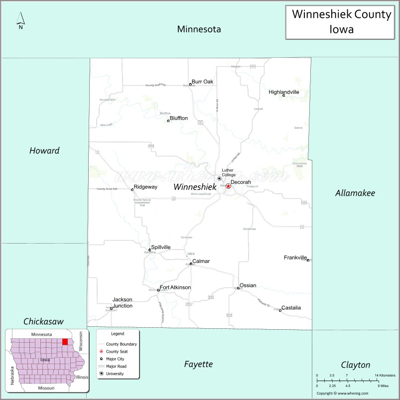
About Winneshiek County Map, Iowa: The map showing the county boundary, county seat, major cities, highways, water bodies and neighbouring counties.
More Iowa Maps & Info
| Iowa Map | Iowa County Map | Iowa Cities Map |
| Iowa Zip codes | Where is Iowa | Airports in Iowa |
| Iowa Area Codes | Iowa Blank Map | Iowa River Map |
| Iowa Physical Map | Iowa Road Map | Where is Des Moines |
Map of Winneshiek County, Iowa
Winneshiek County is a county located in the U.S. state of Iowa. It's county seat is Decorah. As per 2020 census, the population of Winneshiek County is 19892 people and population density is square miles. According to the United States Census Bureau, the county has a total area of 690 sq mi (1,787 km2). Winneshiek County was established on -19306.
Winneshiek County Facts
| Continent | North America |
| Country | United States |
| State | Iowa |
| County Seat | Decorah |
| Largest City/Town | Decorah |
| Established | February 20, 1847 |
| Total Area | 690 sq mi (1,787 sq km) |
| Land Area | 690 sq mi (1,787 sq km) |
| Water Area | 0.4 sq mi (1 sq km) |
| Population | 20,070 (Census 2020) |
| Population Density | 29.1 people per sq mi |
| Time Zone | Central Time Zone (CT) |
| Major Highways | U.S. Highway 52, Iowa Highway 9, Iowa Highway 24, Iowa Highway 139, Iowa Highway 150 |
| Major Rivers | Upper Iowa River, Turkey River, Yellow River |
| Neighboring Counties | Howard County, Chickasaw County, Fayette County, Allamakee County, Fillmore County (MN), Houston County (MN) |
| Famous For | Decorah, Norwegian heritage, Luther College, Trout Run Trail, scenic Driftless Area landscapes |
| Top Attractions | Vesterheim Norwegian-American Museum, Dunning's Spring Park, Luther College, Ice Cave State Preserve |
| Official Website | Official Website |
About Winneshiek County, Iowa
Winneshiek County is located in northeastern Iowa within the scenic Driftless Area and was established in 1847. The county seat and largest city is Decorah. Known for its rolling hills, limestone bluffs, trout streams, and strong Norwegian heritage, Winneshiek County is one of Iowa's premier tourism destinations. Agriculture, education, healthcare, manufacturing, and tourism form the backbone of the local economy, while Decorah serves as a cultural center for the region.
Cities and Towns in Winneshiek County, Iowa
| City/Town | Population (Census 2020) | Latitude & Longitude |
|---|---|---|
| Decorah (county seat) | 7,587 | 43.3033°N, 91.7857°W |
| Calmar | 1,125 | 43.1817°N, 91.8654°W |
| Ossian | 845 | 43.1456°N, 91.7646°W |
| Fort Atkinson | 349 | 43.1439°N, 91.9324°W |
| Castalia | 173 | 43.1147°N, 91.6574°W |
| Spillville | 367 | 43.2047°N, 91.9522°W |
| Ridgeway | 315 | 43.2908°N, 91.9929°W |
| Mabel (partly) | 765 | 43.5203°N, 91.7616°W |
Best Golf Courses in Winneshiek County, Iowa
| Golf Course | Location | Latitude & Longitude |
|---|---|---|
| Oneota Golf & Country Club | Decorah | 43.2925°N, 91.7969°W |
| Silvercrest Golf Club | Decorah | 43.3206°N, 91.7789°W |
| South Winn Golf & Country Club | Calmar | 43.1856°N, 91.8781°W |
| Ossian Golf Course | Ossian | 43.1508°N, 91.7747°W |
What are Major Roads and Highways in Winneshiek County
Several major highways provide access to communities throughout northeastern Iowa and southeastern Minnesota.
- U.S. Highway 52 - major north-south corridor through Decorah and Calmar
- Iowa Highway 9 - east-west route across northern Iowa
- Iowa Highway 24 - connects Decorah with nearby communities
- Iowa Highway 139 - regional route serving northern Winneshiek County
- Iowa Highway 150 - important transportation corridor in the western part of the county
Neighboring Counties of Winneshiek County
- Howard County (west)
- Chickasaw County (southwest)
- Fayette County (south)
- Allamakee County (east)
- Fillmore County, Minnesota (northwest)
- Houston County, Minnesota (northeast)
What are Top Attractions in Winneshiek County, Iowa
Winneshiek County is one of Iowa's premier tourism destinations, offering cultural attractions, outdoor recreation, and scenic landscapes.
| Main Sight Name | City | Famous For |
|---|---|---|
| Vesterheim Norwegian-American Museum | Decorah | National museum of Norwegian-American history and culture |
| Dunning's Spring Park | Decorah | Scenic waterfall and hiking trails |
| Luther College | Decorah | Private liberal arts college and cultural events |
| Ice Cave State Preserve | Decorah | Unique geological formations and hiking |
| Trout Run Trail | Decorah | Popular biking and walking trail |
| Decorah Fish Hatchery | Decorah | Trout production and educational exhibits |
| Fort Atkinson State Preserve | Fort Atkinson | Historic military fort and museum |
| Bily Clocks Museum | Spillville | Historic handcrafted clocks and cultural exhibits |
| Spillville Czech Museum | Spillville | Czech heritage and composer Antonín Dvořák history |
| Upper Iowa River | Countywide | Canoeing, kayaking, fishing, and scenic beauty |
| Seed Savers Exchange Heritage Farm | Decorah Area | Heirloom seed preservation and gardens |
| Winneshiek County Fairgrounds | Decorah | Agricultural fairs and annual events |
Distance from Winneshiek County to Nearby Cities
The following distances are measured by road (driving) from Decorah.
- Decorah to Calmar (Winneshiek County), Iowa - 11 mi (18 km)
- Decorah to Ossian (Winneshiek County), Iowa - 13 mi (21 km)
- Decorah to Spillville (Winneshiek County), Iowa - 13 mi (21 km)
- Decorah to Fort Atkinson (Winneshiek County), Iowa - 16 mi (26 km)
- Decorah to Cresco (Howard County), Iowa - 17 mi (27 km)
- Decorah to New Hampton (Chickasaw County), Iowa - 31 mi (50 km)
- Decorah to West Union (Fayette County), Iowa - 28 mi (45 km)
- Decorah to Waukon (Allamakee County), Iowa - 27 mi (43 km)
- Decorah to Preston, Minnesota - 24 mi (39 km)
- Decorah to La Crosse, Wisconsin - 65 mi (105 km)
- Decorah to Rochester, Minnesota - 72 mi (116 km)
- Decorah to Waterloo (Black Hawk County), Iowa - 72 mi (116 km)
- Decorah to Cedar Rapids (Linn County), Iowa - 112 mi (180 km)
- Decorah to Des Moines (Polk County), Iowa - 194 mi (312 km)
- Decorah to Minneapolis, Minnesota - 167 mi (269 km)
Nearest Airports
Nearest airport of Winneshiek is Decorah Municipal Airport (IATA: DEH, ICAO: KDEH, FAA LID: DEH).
References
- U.S. Census Bureau - Winneshiek County QuickFacts
- Winneshiek County Official Website
- Visit Decorah
- United States Geological Survey (USGS)
- National Geodetic Survey (NGS)
- Adair County Map
- Adams County Map
- Allamakee County Map
- Appanoose County Map
- Audubon County Map
- Benton County Map
- Black Hawk County Map
- Boone County Map
- Bremer County Map
- Buchanan County Map
- Buena Vista County Map
- Butler County Map
- Calhoun County Map
- Carroll County Map
- Cass County Map
- Cedar County Map
- Cerro Gordo County Map
- Cherokee County Map
- Chickasaw County Map
- Clarke County Map
- Clay County Map
- Clayton County Map
- Clinton County Map
- Crawford County Map
- Dallas County Map
- Davis County Map
- Decatur County Map
- Delaware County Map
- Des Moines County Map
- Dickinson County Map
- Dubuque County Map
- Emmet County Map
- Fayette County Map
- Floyd County Map
- Franklin County Map
- Fremont County Map
- Greene County Map
- Grundy County Map
- Guthrie County Map
- Hamilton County Map
- Hancock County Map
- Hardin County Map
- Harrison County Map
- Henry County Map
- Howard County Map
- Humboldt County Map
- Ida County Map
- Iowa County Map
- Jackson County Map
- Jasper County Map
- Jefferson County Map
- Johnson County Map
- Jones County Map
- Keokuk County Map
- Kossuth County Map
- Lee County Map
- Linn County Map
- Louisa County Map
- Lucas County Map
- Lyon County Map
- Madison County Map
- Mahaska County Map
- Marion County Map
- Marshall County Map
- Mills County Map
- Mitchell County Map
- Monona County Map
- Monroe County Map
- Montgomery County Map
- Muscatine County Map
- O'Brien County Map
- Osceola County Map
- Page County Map
- Palo Alto County Map
- Plymouth County Map
- Pocahontas County Map
- Polk County Map
- Pottawattamie County Map
- Poweshiek County Map
- Ringgold County Map
- Sac County Map
- Scott County Map
- Shelby County Map
- Sioux County Map
- Story County Map
- Tama County Map
- Taylor County Map
- Union County Map
- Van Buren County Map
- Wapello County Map
- Warren County Map
- Washington County Map
- Wayne County Map
- Webster County Map
- Winnebago County Map
- Winneshiek County Map
- Woodbury County Map
- Worth County Map
- Wright County Map
- Alabama Counties
- Alaska boroughs
- Arizona Counties
- Arkansas Counties
- California County Map
- Colorado Counties
- Connecticut Counties
- Delaware Counties
- Florida County Map
- Georgia County Map
- Hawaii Counties
- Idaho Counties
- Illinois Counties
- Indiana Counties
- Iowa Counties
- Kansas Counties
- Kentucky Counties
- Louisiana Counties
- Maine Counties
- Maryland Counties
- Massachusetts Counties
- Michigan County Map
- Minnesota Counties
- Mississippi Counties
- Missouri Counties
- Montana Counties
- Nebraska Counties
- Nevada Counties
- New York Counties
- New Hampshire Counties
- New Jersey Counties
- New Mexico Counties
- North Carolina Counties
- North Dakota Counties
- Ohio County Map
- Oklahoma Counties
- Oregon Counties
- Pennsylvania Counties
- Rhode Island Counties
- South Carolina Counties
- South Dakota Counties
- Map of Tennessee
- Texas County Map
- Utah Counties
- Vermont Counties
- Virginia Counties
- Washington Counties
- West Virginia Counties
- Wisconsin Counties
- Wyoming Counties