Map of Boone County - Boone County is a county located in the U.S. state of Illinois. Boone County Map showing cities, highways, important places and water bodies. Get Where is Boone County located in the map, major cities in Boone county, population, areas, and places of interest.
Boone County Map, Illinois
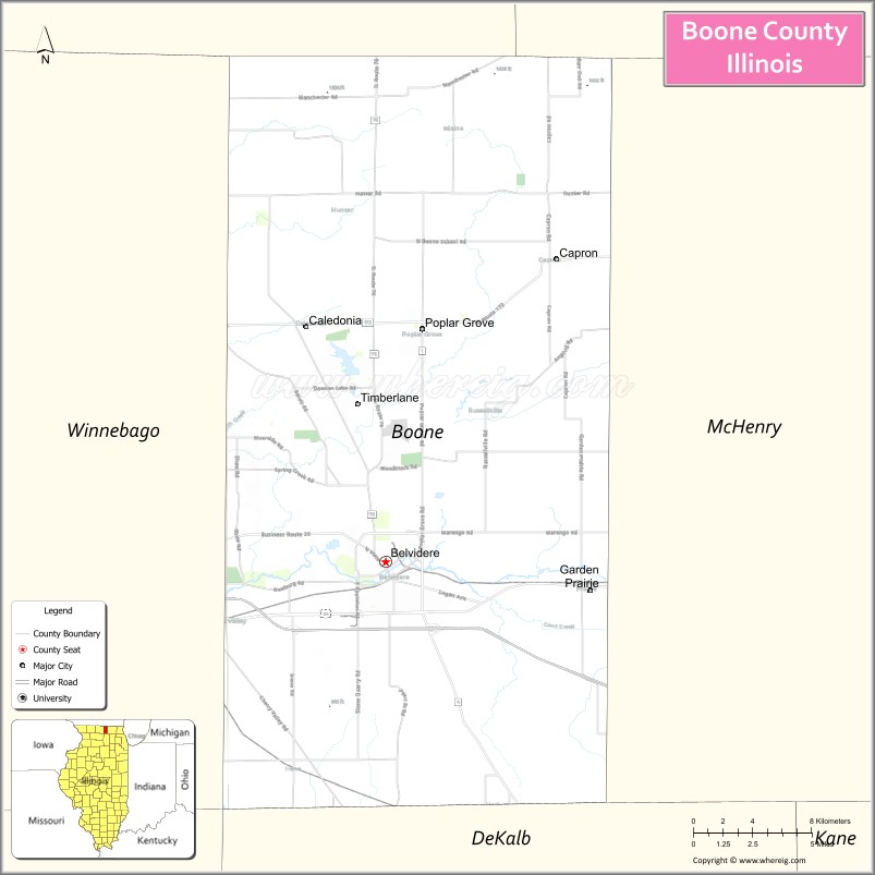
About Boone County Map, Illinois: The map showing the county boundary, county seat, major cities, highways, water bodies and neighbouring counties.
Most Viewed Links
Boone County, Illinois
Boone County is a county located in the U.S. state of Illinois. It's county seat is Belvidere. As per 2020 census, the population of Boone County is 53159 people and population density is square miles. According to the United States Census Bureau, the county has a total area of 280 sq mi (725 km2). Boone County was established on 1837.
Facts about Boone County, Illinois
| Country | United States |
| State | Illinois |
| Region | Northern Illinois |
| County Seat | Belvidere |
| Named After | Daniel Boone |
| Established | 1837 |
| Organized | 1837 |
| Coordinates | 42.32° N, 88.82° W |
| Total Area | ~281 sq mi |
| Land Area | ~280 sq mi |
| Water Area | ~1 sq mi |
| Population (2020) | ~53,448 |
| Population Rank | Mid-sized county in Illinois |
| Largest City | Belvidere |
| Main Industries | Manufacturing, Logistics, Agriculture, Healthcare |
| Major Highway | Interstate 90 |
| Time Zone | Central Time (UTC−06:00) |
| Known For | Kishwaukee River, historic Belvidere downtown, auto manufacturing heritage |
| Website | https://www.boonecountyil.gov |
Ctities in Boone county
| City Name | Type | Population (2020) | Pop. Density | Area |
|---|---|---|---|---|
| Belvidere | City | 25,339 | 2,100.4/sq mi (811.0/km2) | 12.064 sq mi (31.25 km2) |
| Caledonia | Village | 183 | 176.8/sq mi (68.3/km2) | 1.035 sq mi (2.68 km2) |
| Capron | Village | 1,395 | 1,816.4/sq mi (701.3/km2) | 0.768 sq mi (1.99 km2) |
| Poplar Grove | Village | 5,049 | 658.9/sq mi (254.4/km2) | 7.663 sq mi (19.85 km2) |
| Timberlane | Village | 906 | 518.9/sq mi (200.3/km2) | 1.746 sq mi (4.52 km2) |
| Loves Park | City | 23,397 | 1,433.2/sq mi (553.4/km2) | 16.325 sq mi (42.28 km2) |
- Adams County Map
- Alexander County Map
- Bond County Map
- Boone County Map
- Brown County Map
- Bureau County Map
- Calhoun County Map
- Carroll County Map
- Cass County Map
- Champaign County Map
- Christian County Map
- Clark County Map
- Clay County Map
- Clinton County Map
- Coles County Map
- Cook County Map
- Crawford County Map
- Cumberland County Map
- DeKalb County Map
- DeWitt County Map
- Douglas County Map
- DuPage County Map
- Edgar County Map
- Edwards County Map
- Effingham County Map
- Fayette County Map
- Ford County Map
- Franklin County Map
- Fulton County Map
- Gallatin County Map
- Greene County Map
- Grundy County Map
- Hamilton County Map
- Hancock County Map
- Hardin County Map
- Henderson County Map
- Henry County Map
- Iroquois County Map
- Jackson County Map
- Jasper County Map
- Jefferson County Map
- Jersey County Map
- Jo Daviess County Map
- Johnson County Map
- Kane County Map
- Kankakee County Map
- Kendall County Map
- Knox County Map
- Lake County Map
- LaSalle County Map
- Lawrence County Map
- Lee County Map
- Livingston County Map
- Logan County Map
- McDonough County Map
- McHenry County Map
- McLean County Map
- Macon County Map
- Macoupin County Map
- Madison County Map
- Marion County Map
- Marshall County Map
- Mason County Map
- Massac County Map
- Menard County Map
- Mercer County Map
- Monroe County Map
- Montgomery County Map
- Morgan County Map
- Moultrie County Map
- Ogle County Map
- Peoria County Map
- Perry County Map
- Piatt County Map
- Pike County Map
- Pope County Map
- Pulaski County Map
- Putnam County Map
- Randolph County Map
- Richland County Map
- Rock Island County Map
- St Clair County Map
- Saline County Map
- Sangamon County Map
- Schuyler County Map
- Scott County Map
- Shelby County Map
- Stark County Map
- Stephenson County Map
- Tazewell County Map
- Union County Map
- Vermilion County Map
- Wabash County Map
- Warren County Map
- Washington County Map
- Wayne County Map
- White County Map
- Whiteside County Map
- Will County Map
- Williamson County Map
- Winnebago County Map
- Woodford County Map
- Alabama Counties
- Alaska boroughs
- Arizona Counties
- Arkansas Counties
- California County Map
- Colorado Counties
- Connecticut Counties
- Delaware Counties
- Florida County Map
- Georgia County Map
- Hawaii Counties
- Idaho Counties
- Illinois Counties
- Indiana Counties
- Iowa Counties
- Kansas Counties
- Kentucky Counties
- Louisiana Counties
- Maine Counties
- Maryland Counties
- Massachusetts Counties
- Michigan County Map
- Minnesota Counties
- Mississippi Counties
- Missouri Counties
- Montana Counties
- Nebraska Counties
- New Hampshire Counties
- New Jersey Counties
- New Mexico Counties
- North Carolina Counties
- North Dakota Counties
- Oklahoma Counties
- Oregon Counties
- Pennsylvania Counties
- Rhode Island Counties
- South Carolina Counties
- South Dakota Counties
- Map of Tennessee
- Texas County Map
- Utah Counties
- Vermont Counties
- Virginia Counties
- Washington Counties
- West Virginia Counties
- Wisconsin Counties
- Wyoming Counties
- Nevada Counties
- New York Counties
- Ohio County Map