Map of Kendall County - Kendall County is a county located in the U.S. state of Illinois. Kendall County Map showing cities, highways, important places and water bodies. Get Where is Kendall County located in the map, major cities in Kendall county, population, areas, and places of interest.
Kendall County Map, Illinois
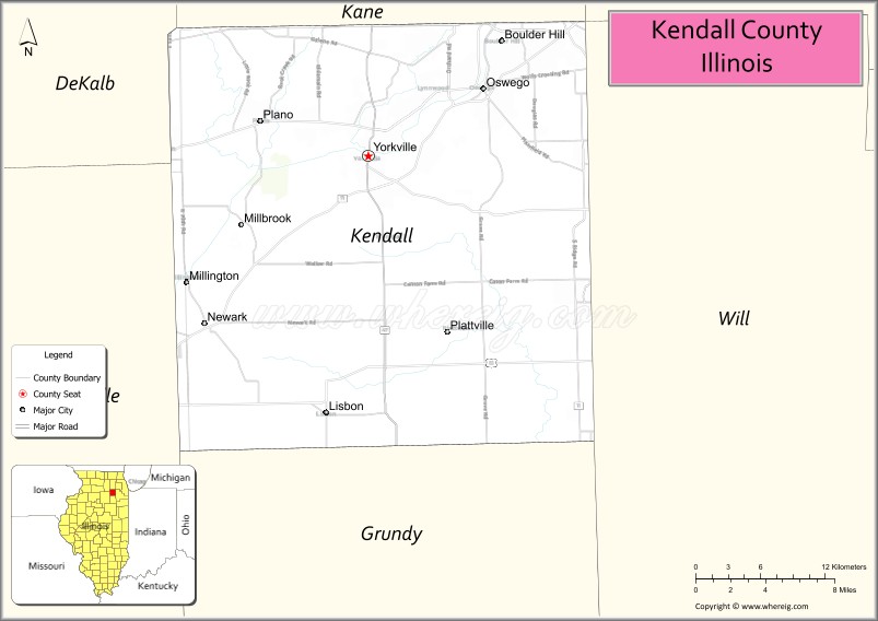
About Kendall County Map, Illinois: The map showing the county boundary, county seat, major cities, highways, water bodies and neighbouring counties.
Most Viewed Illinois Links
Kendall County, Illinois
Kendall County is a county located in the U.S. state of Illinois. It's county seat is Yorkville. As per 2020 census, the population of Kendall County is 134867 people and population density is square miles. According to the United States Census Bureau, the county has a total area of 320 sq mi (829 km2). Kendall County was established on 1841.
Facts about Kendall County, Illinois
| Country | United States |
| State | Illinois |
| Region | Northeastern Illinois |
| County Seat | Yorkville |
| Named After | Amos Kendall |
| Established | 1841 |
| Organized | 1841 |
| Coordinates | 41.58° N, 88.43° W |
| Total Area | ~322 sq mi |
| Land Area | ~320 sq mi |
| Water Area | ~2 sq mi |
| Population (2020) | ~54,570 |
| Population Rank | Mid-sized county in Illinois |
| Largest Cities | Oswego, Yorkville |
| Main Industries | Manufacturing, Logistics, Retail, Agriculture |
| Major River | Fox River |
| Time Zone | Central Time (UTC−06:00) |
| Known For | Rapid suburban growth, Fox River Valley, rural heritage |
| Website | https://www.co.kendall.il.us |
Ctities in Kendall county
| City Name | Type | Population (2020) | Pop. Density | Area |
|---|---|---|---|---|
| Sandwich | City | 7,221 | 1,524.7/sq mi (588.7/km2) | 4.736 sq mi (12.27 km2) |
| Aurora | City | 180,542 | 4,010.0/sq mi (1,548.3/km2) | 45.023 sq mi (116.61 km2) |
| Montgomery | Village | 20,262 | 2,178.9/sq mi (841.3/km2) | 9.299 sq mi (24.08 km2) |
| Lisbon | Village | 271 | 128.0/sq mi (49.4/km2) | 2.117 sq mi (5.48 km2) |
| Millbrook | Village | 277 | 150.1/sq mi (57.9/km2) | 1.846 sq mi (4.78 km2) |
| Newark | Village | 973 | 865.7/sq mi (334.2/km2) | 1.124 sq mi (2.91 km2) |
| Oswego | Village | 34,585 | 2,323.0/sq mi (896.9/km2) | 14.888 sq mi (38.56 km2) |
| Plano | City | 11,847 | 1,319.4/sq mi (509.4/km2) | 8.979 sq mi (23.26 km2) |
| Plattville | Village | 220 | 97.4/sq mi (37.6/km2) | 2.259 sq mi (5.85 km2) |
| Yorkville | City | 21,533 | 1,076.8/sq mi (415.8/km2) | 19.997 sq mi (51.79 km2) |
| Millington | Village | 617 | 871.5/sq mi (336.5/km2) | 0.708 sq mi (1.83 km2) |
| Joliet | City | 150,362 | 2,330.6/sq mi (899.9/km2) | 64.516 sq mi (167.1 km2) |
Roads and Highways in Kendall County, Illinois
Kendall County is well-connected by major highways that provide easy access to Chicago and the surrounding suburban regions.
- Interstate 80 – runs east-west through the southern part of the county, connecting Yorkville to Joliet and Ottawa
- U.S. Route 34 – runs east-west, linking Plano and Yorkville to Aurora and Oswego
- Illinois Route 47 – runs north-south, connecting Yorkville to Morris and Sugar Grove
- Illinois Route 71 – runs east-west, linking Yorkville to Ottawa and Oswego
- Illinois Route 126 – runs east-west, connecting Yorkville to Plainfield and Joliet
Neighboring Counties of Kendall County
- Kane County (north)
- DuPage County (northeast)
- Will County (east)
- Grundy County (south)
- LaSalle County (west)
Top Attractions in Kendall County, Illinois
Kendall County offers a mix of suburban growth, parks, and riverfront recreation along the Fox River.
- Silver Springs State Park – A scenic park with trails, fishing, and picnic areas.
- Fox River Park – Offers walking paths, kayaking, and riverfront views.
- Kendall County Historical Society – Preserves local history and heritage.
- Yorkville Downtown Area – Features shops, restaurants, and community events.
- Raging Waves Waterpark – A popular family attraction with slides and pools.
- Hoover Forest Preserve – Provides trails, open space, and nature viewing.
- Marne Road Park – A local park with sports fields and playgrounds.
Distance from Kendall County to Nearby Cities
- Yorkville to Chicago – 50 mi (80 km)
- Yorkville to Aurora – 10 mi (16 km)
- Yorkville to Joliet – 20 mi (32 km)
- Yorkville to Naperville – 25 mi (40 km)
- Yorkville to Ottawa – 35 mi (56 km)
FAQs about Kendall County
Kendall County is located in northeastern Illinois, southwest of Chicago.
The county is known for its fast-growing communities, parks, and access to the Fox River.
Yorkville is the county seat and the largest city in Kendall County.
Yes, visitors can enjoy parks, river activities, trails, and outdoor recreation throughout the county.
Kendall County is accessible via Interstate 80, U.S. Route 34, and several Illinois state highways.
- Adams County Map
- Alexander County Map
- Bond County Map
- Boone County Map
- Brown County Map
- Bureau County Map
- Calhoun County Map
- Carroll County Map
- Cass County Map
- Champaign County Map
- Christian County Map
- Clark County Map
- Clay County Map
- Clinton County Map
- Coles County Map
- Cook County Map
- Crawford County Map
- Cumberland County Map
- DeKalb County Map
- DeWitt County Map
- Douglas County Map
- DuPage County Map
- Edgar County Map
- Edwards County Map
- Effingham County Map
- Fayette County Map
- Ford County Map
- Franklin County Map
- Fulton County Map
- Gallatin County Map
- Greene County Map
- Grundy County Map
- Hamilton County Map
- Hancock County Map
- Hardin County Map
- Henderson County Map
- Henry County Map
- Iroquois County Map
- Jackson County Map
- Jasper County Map
- Jefferson County Map
- Jersey County Map
- Jo Daviess County Map
- Johnson County Map
- Kane County Map
- Kankakee County Map
- Kendall County Map
- Knox County Map
- Lake County Map
- LaSalle County Map
- Lawrence County Map
- Lee County Map
- Livingston County Map
- Logan County Map
- McDonough County Map
- McHenry County Map
- McLean County Map
- Macon County Map
- Macoupin County Map
- Madison County Map
- Marion County Map
- Marshall County Map
- Mason County Map
- Massac County Map
- Menard County Map
- Mercer County Map
- Monroe County Map
- Montgomery County Map
- Morgan County Map
- Moultrie County Map
- Ogle County Map
- Peoria County Map
- Perry County Map
- Piatt County Map
- Pike County Map
- Pope County Map
- Pulaski County Map
- Putnam County Map
- Randolph County Map
- Richland County Map
- Rock Island County Map
- St Clair County Map
- Saline County Map
- Sangamon County Map
- Schuyler County Map
- Scott County Map
- Shelby County Map
- Stark County Map
- Stephenson County Map
- Tazewell County Map
- Union County Map
- Vermilion County Map
- Wabash County Map
- Warren County Map
- Washington County Map
- Wayne County Map
- White County Map
- Whiteside County Map
- Will County Map
- Williamson County Map
- Winnebago County Map
- Woodford County Map
- Alabama Counties
- Alaska boroughs
- Arizona Counties
- Arkansas Counties
- California County Map
- Colorado Counties
- Connecticut Counties
- Delaware Counties
- Florida County Map
- Georgia County Map
- Hawaii Counties
- Idaho Counties
- Illinois Counties
- Indiana Counties
- Iowa Counties
- Kansas Counties
- Kentucky Counties
- Louisiana Counties
- Maine Counties
- Maryland Counties
- Massachusetts Counties
- Michigan County Map
- Minnesota Counties
- Mississippi Counties
- Missouri Counties
- Montana Counties
- Nebraska Counties
- Nevada Counties
- New York Counties
- New Hampshire Counties
- New Jersey Counties
- New Mexico Counties
- North Carolina Counties
- North Dakota Counties
- Ohio County Map
- Oklahoma Counties
- Oregon Counties
- Pennsylvania Counties
- Rhode Island Counties
- South Carolina Counties
- South Dakota Counties
- Map of Tennessee
- Texas County Map
- Utah Counties
- Vermont Counties
- Virginia Counties
- Washington Counties
- West Virginia Counties
- Wisconsin Counties
- Wyoming Counties