Map of Jackson County - Jackson County is a county located in the U.S. state of Illinois. Jackson County Map showing cities, highways, important places and water bodies. Get Where is Jackson County located in the map, major cities in Jackson county, population, areas, and places of interest.
Jackson County Map, Illinois
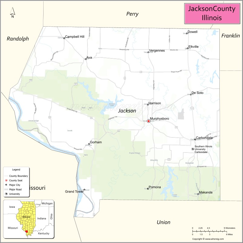
About Jackson County Map, Illinois: The map showing the county boundary, county seat, major cities, highways, water bodies and neighbouring counties.
Most Viewed Illinois Links
Jackson County, Illinois
Jackson County is a county located in the U.S. state of Illinois. It's county seat is Murphysboro. As per 2020 census, the population of Jackson County is 52565 people and population density is square miles. According to the United States Census Bureau, the county has a total area of 584 sq mi (1,513 km2). Jackson County was established on 1816.
Facts about Jackson County, Illinois
| Country | United States |
| State | Illinois |
| Region | Southern Illinois |
| County Seat | Murphysboro |
| Named After | Andrew Jackson |
| Established | 1816 |
| Organized | 1816 |
| Coordinates | 37.79° N, 89.38° W |
| Total Area | ~602 sq mi |
| Land Area | ~584 sq mi |
| Water Area | ~18 sq mi |
| Population (2020) | ~52,974 |
| Population Rank | Mid-sized county in Illinois |
| Largest City | Carbondale |
| Main Industries | Education, Healthcare, Government, Tourism |
| Major University | Southern Illinois University Carbondale |
| Time Zone | Central Time (UTC−06:00) |
| Known For | Higher education, Shawnee National Forest nearby, outdoor recreation |
| Website | https://www.jacksoncounty-il.gov |
Ctities in Jackson county
| City Name | Type | Population (2020) | Pop. Density | Area |
|---|---|---|---|---|
| Ava | City | 553 | 523.2/sq mi (202.0/km2) | 1.057 sq mi (2.74 km2) |
| Campbell Hill | Village | 309 | 668.8/sq mi (258.2/km2) | 0.462 sq mi (1.2 km2) |
| Carbondale | City | 21,857 | 1,256.4/sq mi (485.1/km2) | 17.397 sq mi (45.06 km2) |
| De Soto | Village | 1,407 | 1,542.8/sq mi (595.7/km2) | 0.912 sq mi (2.36 km2) |
| Dowell | Village | 368 | 943.6/sq mi (364.3/km2) | 0.39 sq mi (1.01 km2) |
| Elkville | Village | 838 | 1,092.6/sq mi (421.8/km2) | 0.767 sq mi (1.99 km2) |
| Gorham | Village | 173 | 141.9/sq mi (54.8/km2) | 1.219 sq mi (3.16 km2) |
| Grand Tower | City | 479 | 383.8/sq mi (148.2/km2) | 1.248 sq mi (3.23 km2) |
| Makanda | Village | 547 | 103.6/sq mi (40.0/km2) | 5.281 sq mi (13.68 km2) |
| Murphysboro | City | 7,093 | 1,351.6/sq mi (521.8/km2) | 5.248 sq mi (13.59 km2) |
| Vergennes | Village | 235 | 667.6/sq mi (257.8/km2) | 0.352 sq mi (0.91 km2) |
Roads and Highways in Jackson County, Illinois
Jackson County is well-connected by major highways that link it to southern Illinois and surrounding regions.
- Interstate 57 – runs north-south through the county, connecting Carbondale to Marion and Mount Vernon
- Illinois Route 13 – runs east-west, linking Carbondale to Murphysboro and Marion
- Illinois Route 127 – runs north-south, connecting Murphysboro to Jonesboro and Pinckneyville
- Illinois Route 149 – runs east-west, linking Murphysboro to Herrin and Hurst
- Illinois Route 3 – runs north-south along the western side, connecting the county to Chester and Cairo
Neighboring Counties of Jackson County
- Perry County (north)
- Franklin County (northeast)
- Williamson County (east)
- Union County (southwest)
- Randolph County (northwest)
Top Attractions in Jackson County, Illinois
Jackson County offers a mix of outdoor recreation, cultural sites, and college-town energy centered around Carbondale.
- Southern Illinois University – A major campus with cultural events, museums, and sports.
- Giant City State Park – Known for its unique rock formations, hiking trails, and scenic beauty.
- Little Grand Canyon – A popular hiking destination with dramatic landscapes and views.
- Murphysboro Apple Festival – A well-known annual event celebrating local culture.
- Carbondale Downtown Area – Features shops, dining, and entertainment options.
- Touch of Nature Outdoor Education Center – Offers outdoor activities, trails, and environmental programs.
- Kinkaid Lake (nearby) – A popular spot for boating, fishing, and camping.
Distance from Jackson County to Nearby Cities
- Carbondale to Marion – 15 mi (24 km)
- Carbondale to Cape Girardeau – 50 mi (80 km)
- Carbondale to Paducah – 60 mi (97 km)
- Carbondale to St. Louis – 100 mi (161 km)
- Carbondale to Evansville – 120 mi (193 km)
FAQs about Jackson County
Jackson County is located in southern Illinois, centered around the city of Carbondale.
The county is known for Southern Illinois University, Giant City State Park, and outdoor recreation.
Murphysboro is the county seat, while Carbondale is the largest city in Jackson County.
Yes, visitors can enjoy hiking, camping, lakes, and scenic natural areas throughout the county.
Jackson County is accessible via Interstate 57 and several Illinois state highways including Routes 13, 127, 149, and 3.
- Adams County Map
- Alexander County Map
- Bond County Map
- Boone County Map
- Brown County Map
- Bureau County Map
- Calhoun County Map
- Carroll County Map
- Cass County Map
- Champaign County Map
- Christian County Map
- Clark County Map
- Clay County Map
- Clinton County Map
- Coles County Map
- Cook County Map
- Crawford County Map
- Cumberland County Map
- DeKalb County Map
- DeWitt County Map
- Douglas County Map
- DuPage County Map
- Edgar County Map
- Edwards County Map
- Effingham County Map
- Fayette County Map
- Ford County Map
- Franklin County Map
- Fulton County Map
- Gallatin County Map
- Greene County Map
- Grundy County Map
- Hamilton County Map
- Hancock County Map
- Hardin County Map
- Henderson County Map
- Henry County Map
- Iroquois County Map
- Jackson County Map
- Jasper County Map
- Jefferson County Map
- Jersey County Map
- Jo Daviess County Map
- Johnson County Map
- Kane County Map
- Kankakee County Map
- Kendall County Map
- Knox County Map
- Lake County Map
- LaSalle County Map
- Lawrence County Map
- Lee County Map
- Livingston County Map
- Logan County Map
- McDonough County Map
- McHenry County Map
- McLean County Map
- Macon County Map
- Macoupin County Map
- Madison County Map
- Marion County Map
- Marshall County Map
- Mason County Map
- Massac County Map
- Menard County Map
- Mercer County Map
- Monroe County Map
- Montgomery County Map
- Morgan County Map
- Moultrie County Map
- Ogle County Map
- Peoria County Map
- Perry County Map
- Piatt County Map
- Pike County Map
- Pope County Map
- Pulaski County Map
- Putnam County Map
- Randolph County Map
- Richland County Map
- Rock Island County Map
- St Clair County Map
- Saline County Map
- Sangamon County Map
- Schuyler County Map
- Scott County Map
- Shelby County Map
- Stark County Map
- Stephenson County Map
- Tazewell County Map
- Union County Map
- Vermilion County Map
- Wabash County Map
- Warren County Map
- Washington County Map
- Wayne County Map
- White County Map
- Whiteside County Map
- Will County Map
- Williamson County Map
- Winnebago County Map
- Woodford County Map
- Alabama Counties
- Alaska boroughs
- Arizona Counties
- Arkansas Counties
- California County Map
- Colorado Counties
- Connecticut Counties
- Delaware Counties
- Florida County Map
- Georgia County Map
- Hawaii Counties
- Idaho Counties
- Illinois Counties
- Indiana Counties
- Iowa Counties
- Kansas Counties
- Kentucky Counties
- Louisiana Counties
- Maine Counties
- Maryland Counties
- Massachusetts Counties
- Michigan County Map
- Minnesota Counties
- Mississippi Counties
- Missouri Counties
- Montana Counties
- Nebraska Counties
- Nevada Counties
- New York Counties
- New Hampshire Counties
- New Jersey Counties
- New Mexico Counties
- North Carolina Counties
- North Dakota Counties
- Ohio County Map
- Oklahoma Counties
- Oregon Counties
- Pennsylvania Counties
- Rhode Island Counties
- South Carolina Counties
- South Dakota Counties
- Map of Tennessee
- Texas County Map
- Utah Counties
- Vermont Counties
- Virginia Counties
- Washington Counties
- West Virginia Counties
- Wisconsin Counties
- Wyoming Counties