Map of Livingston County - Livingston County is a county located in the U.S. state of Illinois. Livingston County Map showing cities, highways, important places and water bodies. Get Where is Livingston County located in the map, major cities in Livingston county, population, areas, and places of interest.
Livingston County Map, Illinois
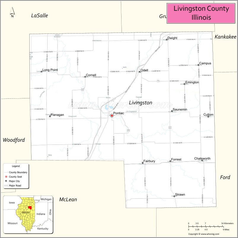
About Livingston County Map, Illinois: The map showing the county boundary, county seat, major cities, highways, water bodies and neighbouring counties.
Most Viewed Illinois Links
Livingston County, Illinois
Livingston County is a county located in the U.S. state of Illinois. It's county seat is Pontiac. As per 2020 census, the population of Livingston County is 35664 people and population density is square miles. According to the United States Census Bureau, the county has a total area of 1,043 sq mi (2,701 km2). Livingston County was established on 1837.
Facts about Livingston County, Illinois
| Country | United States |
| State | Illinois |
| Region | North Central Illinois |
| County Seat | Pontiac |
| Named After | Edward Livingston |
| Established | 1837 |
| Organized | 1837 |
| Coordinates | 40.90° N, 88.55° W |
| Total Area | ~1,046 sq mi |
| Land Area | ~1,044 sq mi |
| Water Area | ~2 sq mi |
| Population (2020) | ~35,648 |
| Population Rank | Mid-sized county in Illinois |
| Largest City | Pontiac |
| Main Industries | Agriculture, Manufacturing, Healthcare, Transportation |
| Major Highways | Interstate 55, U.S. Route 66 |
| Time Zone | Central Time (UTC−06:00) |
| Known For | Route 66 heritage, agriculture, historic downtown Pontiac |
| Website | https://www.livingstoncountyil.gov |
Ctities in Livingston county
| City Name | Type | Population (2020) | Pop. Density | Area |
|---|---|---|---|---|
| Streator | City | 12,500 | 1,714.0/sq mi (661.8/km2) | 7.293 sq mi (18.89 km2) |
| Campus | Village | 149 | 1,619.6/sq mi (625.3/km2) | 0.092 sq mi (0.24 km2) |
| Chatsworth | Town | 1,185 | 429.8/sq mi (166.0/km2) | 2.757 sq mi (7.14 km2) |
| Cornell | Village | 446 | 682.0/sq mi (263.3/km2) | 0.654 sq mi (1.69 km2) |
| Cullom | Village | 520 | 1,552.2/sq mi (599.3/km2) | 0.335 sq mi (0.87 km2) |
| Emington | Village | 101 | 1,216.9/sq mi (469.8/km2) | 0.083 sq mi (0.21 km2) |
| Fairbury | City | 3,633 | 2,008.3/sq mi (775.4/km2) | 1.809 sq mi (4.69 km2) |
| Flanagan | Village | 1,010 | 1,759.6/sq mi (679.4/km2) | 0.574 sq mi (1.49 km2) |
| Forrest | Village | 1,041 | 1,606.5/sq mi (620.3/km2) | 0.648 sq mi (1.68 km2) |
| Long Point | Village | 204 | 1,102.7/sq mi (425.8/km2) | 0.185 sq mi (0.48 km2) |
| Odell | Village | 1,003 | 931.3/sq mi (359.6/km2) | 1.077 sq mi (2.79 km2) |
| Pontiac | City | 11,150 | 1,330.2/sq mi (513.6/km2) | 8.382 sq mi (21.71 km2) |
| Reddick | Village | 199 | 832.6/sq mi (321.5/km2) | 0.239 sq mi (0.62 km2) |
| Saunemin | Village | 406 | 1,757.6/sq mi (678.6/km2) | 0.231 sq mi (0.6 km2) |
| Strawn | Village | 101 | 198.0/sq mi (76.5/km2) | 0.51 sq mi (1.32 km2) |
| Dwight | Village | 4,032 | 1,222.9/sq mi (472.2/km2) | 3.297 sq mi (8.54 km2) |
Roads and Highways in Livingston County, Illinois
Livingston County is a key transportation corridor with major interstates and highways connecting it to central and northern Illinois.
- Interstate 55 – runs north-south through the county, connecting Pontiac to Chicago and Bloomington
- Interstate 39 – runs north-south along the eastern side, linking the county to Normal and LaSalle
- U.S. Route 24 – runs east-west, connecting Pontiac to Peoria and Watseka
- Illinois Route 17 – runs east-west, linking Dwight to Kankakee and Wenona
- Illinois Route 23 – runs north-south, connecting Pontiac to Streator and Fairbury
Neighboring Counties of Livingston County
- LaSalle County (north)
- Kankakee County (northeast)
- Iroquois County (east)
- Ford County (south)
- McLean County (southwest)
- Woodford County (west)
- Grundy County (northwest)
Top Attractions in Livingston County, Illinois
Livingston County offers historic sites, parks, and small-town charm across its communities.
- Pontiac Oakland Automobile Museum – Showcases classic cars and automotive history.
- Livingston County War Museum – Features military artifacts and exhibits.
- Route 66 Hall of Fame & Museum – Highlights the history of the iconic highway.
- Humiston Woods Nature Preserve – Offers trails and scenic natural surroundings.
- Pontiac Murals – A collection of large outdoor murals throughout the city.
- Old Log Cabin – A historic site preserving early settler history.
- Livingston County Fairgrounds – Hosts annual fairs and community events.
Distance from Livingston County to Nearby Cities
- Pontiac to Bloomington – 35 mi (56 km)
- Pontiac to Joliet – 60 mi (97 km)
- Pontiac to Chicago – 95 mi (153 km)
- Pontiac to Peoria – 60 mi (97 km)
- Pontiac to Kankakee – 50 mi (80 km)
FAQs about Livingston County
Livingston County is located in central Illinois, centered around the city of Pontiac.
The county is known for Route 66 attractions, historic museums, and small-town communities.
Pontiac is the county seat and the largest city in Livingston County.
Yes, visitors can enjoy parks, nature preserves, and outdoor recreation areas throughout the county.
Livingston County is accessible via Interstates 55 and 39, along with several U.S. and state highways.
- Adams County Map
- Alexander County Map
- Bond County Map
- Boone County Map
- Brown County Map
- Bureau County Map
- Calhoun County Map
- Carroll County Map
- Cass County Map
- Champaign County Map
- Christian County Map
- Clark County Map
- Clay County Map
- Clinton County Map
- Coles County Map
- Cook County Map
- Crawford County Map
- Cumberland County Map
- DeKalb County Map
- DeWitt County Map
- Douglas County Map
- DuPage County Map
- Edgar County Map
- Edwards County Map
- Effingham County Map
- Fayette County Map
- Ford County Map
- Franklin County Map
- Fulton County Map
- Gallatin County Map
- Greene County Map
- Grundy County Map
- Hamilton County Map
- Hancock County Map
- Hardin County Map
- Henderson County Map
- Henry County Map
- Iroquois County Map
- Jackson County Map
- Jasper County Map
- Jefferson County Map
- Jersey County Map
- Jo Daviess County Map
- Johnson County Map
- Kane County Map
- Kankakee County Map
- Kendall County Map
- Knox County Map
- Lake County Map
- LaSalle County Map
- Lawrence County Map
- Lee County Map
- Livingston County Map
- Logan County Map
- McDonough County Map
- McHenry County Map
- McLean County Map
- Macon County Map
- Macoupin County Map
- Madison County Map
- Marion County Map
- Marshall County Map
- Mason County Map
- Massac County Map
- Menard County Map
- Mercer County Map
- Monroe County Map
- Montgomery County Map
- Morgan County Map
- Moultrie County Map
- Ogle County Map
- Peoria County Map
- Perry County Map
- Piatt County Map
- Pike County Map
- Pope County Map
- Pulaski County Map
- Putnam County Map
- Randolph County Map
- Richland County Map
- Rock Island County Map
- St Clair County Map
- Saline County Map
- Sangamon County Map
- Schuyler County Map
- Scott County Map
- Shelby County Map
- Stark County Map
- Stephenson County Map
- Tazewell County Map
- Union County Map
- Vermilion County Map
- Wabash County Map
- Warren County Map
- Washington County Map
- Wayne County Map
- White County Map
- Whiteside County Map
- Will County Map
- Williamson County Map
- Winnebago County Map
- Woodford County Map
- Alabama Counties
- Alaska boroughs
- Arizona Counties
- Arkansas Counties
- California County Map
- Colorado Counties
- Connecticut Counties
- Delaware Counties
- Florida County Map
- Georgia County Map
- Hawaii Counties
- Idaho Counties
- Illinois Counties
- Indiana Counties
- Iowa Counties
- Kansas Counties
- Kentucky Counties
- Louisiana Counties
- Maine Counties
- Maryland Counties
- Massachusetts Counties
- Michigan County Map
- Minnesota Counties
- Mississippi Counties
- Missouri Counties
- Montana Counties
- Nebraska Counties
- Nevada Counties
- New York Counties
- New Hampshire Counties
- New Jersey Counties
- New Mexico Counties
- North Carolina Counties
- North Dakota Counties
- Ohio County Map
- Oklahoma Counties
- Oregon Counties
- Pennsylvania Counties
- Rhode Island Counties
- South Carolina Counties
- South Dakota Counties
- Map of Tennessee
- Texas County Map
- Utah Counties
- Vermont Counties
- Virginia Counties
- Washington Counties
- West Virginia Counties
- Wisconsin Counties
- Wyoming Counties