Map of Champaign County - Champaign County is a county located in the U.S. state of Illinois. Champaign County Map showing cities, highways, important places and water bodies. Get Where is Champaign County located in the map, major cities in Champaign county, population, areas, and places of interest.
Champaign County Map, Illinois
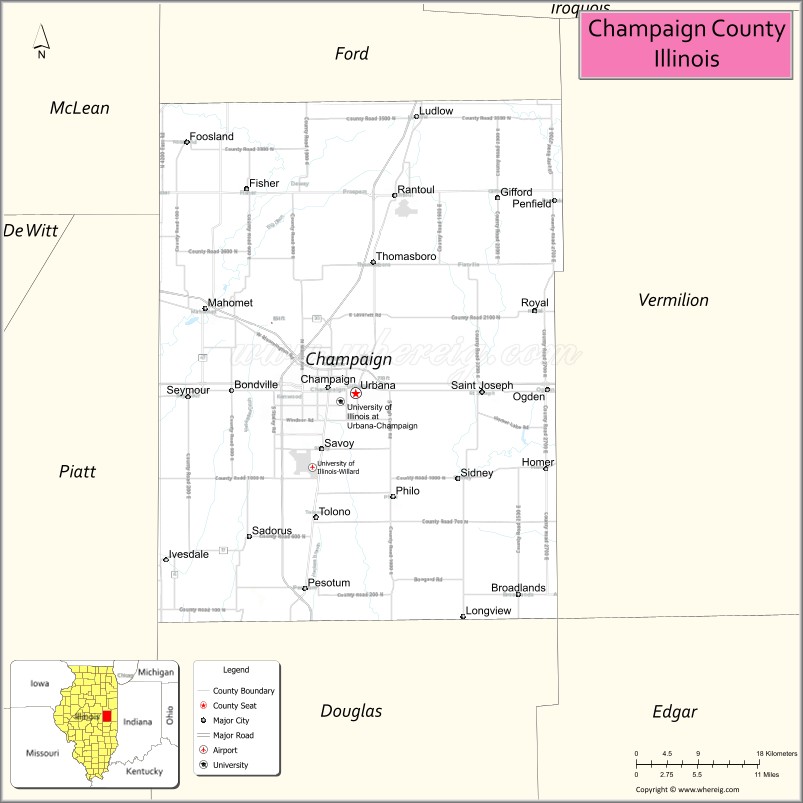
About Champaign County Map, Illinois: The map showing the county boundary, county seat, major cities, highways, water bodies and neighbouring counties.
Most Viewed Illinois Links
Champaign County, Illinois
Champaign County is a county located in the U.S. state of Illinois. It's county seat is Urbana. As per 2020 census, the population of Champaign County is 205943 people and population density is square miles. According to the United States Census Bureau, the county has a total area of 996 sq mi (2,580 km2). Champaign County was established on 1833.
Facts about Champaign County, Illinois
| Country | United States |
| State | Illinois |
| Region | East Central Illinois |
| County Seat | Urbana |
| Named After | Champaign County, Ohio |
| Established | 1833 |
| Organized | 1833 |
| Coordinates | 40.14° N, 88.20° W |
| Total Area | ~998 sq mi |
| Land Area | ~996 sq mi |
| Water Area | ~2 sq mi |
| Population (2020) | ~205,865 |
| Population Rank | One of the most populous counties in Illinois |
| Largest Cities | Champaign, Urbana |
| Main Industries | Education, Technology, Healthcare, Agriculture |
| Major University | University of Illinois Urbana–Champaign |
| Time Zone | Central Time (UTC−06:00) |
| Known For | Major research university, innovation, cultural amenities |
| Website | https://www.co.champaign.il.us |
Ctities in Champaign county
| City Name | Type | Population (2020) | Pop. Density | Area |
|---|---|---|---|---|
| Allerton | Village | 262 | 385.9/sq mi (149.0/km2) | 0.679 sq mi (1.76 km2) |
| Bondville | Village | 388 | 1,545.8/sq mi (596.8/km2) | 0.251 sq mi (0.65 km2) |
| Broadlands | Village | 316 | 981.4/sq mi (378.9/km2) | 0.322 sq mi (0.83 km2) |
| Champaign | City | 88,302 | 3,851.3/sq mi (1,487.0/km2) | 22.928 sq mi (59.38 km2) |
| Fisher | Village | 2,062 | 1,550.4/sq mi (598.6/km2) | 1.33 sq mi (3.44 km2) |
| Foosland | Village | 75 | 1,087.0/sq mi (419.7/km2) | 0.069 sq mi (0.18 km2) |
| Gifford | Village | 911 | 2,051.8/sq mi (792.2/km2) | 0.444 sq mi (1.15 km2) |
| Homer | Village | 1,073 | 1,094.9/sq mi (422.7/km2) | 0.98 sq mi (2.54 km2) |
| Ivesdale | Village | 265 | 370.1/sq mi (142.9/km2) | 0.716 sq mi (1.85 km2) |
| Longview | Village | 112 | 453.4/sq mi (175.1/km2) | 0.247 sq mi (0.64 km2) |
| Ludlow | Village | 308 | 775.8/sq mi (299.5/km2) | 0.397 sq mi (1.03 km2) |
| Mahomet | Village | 9,434 | 970.4/sq mi (374.7/km2) | 9.722 sq mi (25.18 km2) |
| Ogden | Village | 729 | 1,239.8/sq mi (478.7/km2) | 0.588 sq mi (1.52 km2) |
| Pesotum | Village | 550 | 966.6/sq mi (373.2/km2) | 0.569 sq mi (1.47 km2) |
| Philo | Village | 1,392 | 1,679.1/sq mi (648.3/km2) | 0.829 sq mi (2.15 km2) |
| Rantoul | Village | 12,371 | 1,457.1/sq mi (562.6/km2) | 8.49 sq mi (21.99 km2) |
| Royal | Village | 293 | 1,601.1/sq mi (618.2/km2) | 0.183 sq mi (0.47 km2) |
| Sadorus | Village | 402 | 391.4/sq mi (151.1/km2) | 1.027 sq mi (2.66 km2) |
| St. Joseph | Village | 3,810 | 1,829.1/sq mi (706.2/km2) | 2.083 sq mi (5.39 km2) |
| Savoy | Village | 8,857 | 2,739.6/sq mi (1,057.8/km2) | 3.233 sq mi (8.37 km2) |
| Sidney | Village | 1,208 | 1,935.9/sq mi (747.5/km2) | 0.624 sq mi (1.62 km2) |
| Thomasboro | Village | 1,034 | 1,039.2/sq mi (401.2/km2) | 0.995 sq mi (2.58 km2) |
| Tolono | Village | 3,604 | 1,748.7/sq mi (675.2/km2) | 2.061 sq mi (5.34 km2) |
| Urbana | City | 38,336 | 3,240.6/sq mi (1,251.2/km2) | 11.83 sq mi (30.64 km2) |
Roads and Highways in Champaign County, Illinois
Champaign County is a major transportation hub in east-central Illinois, with several interstates and highways connecting it to key cities across the Midwest.
- Interstate 57 – runs north-south, connecting Champaign to Chicago and southern Illinois
- Interstate 74 – runs east-west, linking Champaign-Urbana to Indianapolis and Peoria
- U.S. Route 45 – passes through the county, connecting Urbana to Rantoul and beyond
- U.S. Route 150 – runs east-west, linking Champaign to Danville and Bloomington
- Illinois Route 10 – connects Champaign to Lincoln and nearby communities
Neighboring Counties of Champaign County
- Ford County (north)
- Vermilion County (east)
- Edgar County (southeast)
- Douglas County (south)
- Piatt County (west)
- McLean County (northwest)
Top Attractions in Champaign County, Illinois
Champaign County offers a lively mix of cultural attractions, parks, and educational sites centered around the Champaign-Urbana area.
- University of Illinois Urbana-Champaign – A major campus known for its beautiful grounds and cultural events.
- Krannert Art Museum – Features diverse art collections and exhibitions.
- Spurlock Museum – Showcases global cultures and history through engaging exhibits.
- Hessel Park – A popular community park with playgrounds and walking paths.
- Meadowbrook Park – Offers scenic trails, sculptures, and open green spaces.
- Champaign County Historical Museum – Highlights the region’s history and heritage.
- Market at the Square – A vibrant farmers market in Urbana with local produce and crafts.
- Crystal Lake Park – A scenic park with a lake, trails, and recreational facilities.
Distance from Champaign County to Nearby Cities
- Champaign to Chicago – 135 mi (217 km)
- Champaign to Indianapolis – 120 mi (193 km)
- Champaign to Springfield – 85 mi (137 km)
- Champaign to Peoria – 90 mi (145 km)
- Champaign to St. Louis – 165 mi (266 km)
FAQs about Champaign County
Champaign County is located in east-central Illinois and serves as a key regional center in the state.
The county is known for the University of Illinois, cultural attractions, and a vibrant college-town atmosphere.
Champaign and Urbana are the primary cities, forming a twin-city urban area in the county.
Yes, visitors can enjoy parks, lakes, trails, and outdoor spaces throughout the county.
Champaign County is accessible via Interstates 57 and 74, along with several U.S. and state highways.
- Adams County Map
- Alexander County Map
- Bond County Map
- Boone County Map
- Brown County Map
- Bureau County Map
- Calhoun County Map
- Carroll County Map
- Cass County Map
- Champaign County Map
- Christian County Map
- Clark County Map
- Clay County Map
- Clinton County Map
- Coles County Map
- Cook County Map
- Crawford County Map
- Cumberland County Map
- DeKalb County Map
- DeWitt County Map
- Douglas County Map
- DuPage County Map
- Edgar County Map
- Edwards County Map
- Effingham County Map
- Fayette County Map
- Ford County Map
- Franklin County Map
- Fulton County Map
- Gallatin County Map
- Greene County Map
- Grundy County Map
- Hamilton County Map
- Hancock County Map
- Hardin County Map
- Henderson County Map
- Henry County Map
- Iroquois County Map
- Jackson County Map
- Jasper County Map
- Jefferson County Map
- Jersey County Map
- Jo Daviess County Map
- Johnson County Map
- Kane County Map
- Kankakee County Map
- Kendall County Map
- Knox County Map
- Lake County Map
- LaSalle County Map
- Lawrence County Map
- Lee County Map
- Livingston County Map
- Logan County Map
- McDonough County Map
- McHenry County Map
- McLean County Map
- Macon County Map
- Macoupin County Map
- Madison County Map
- Marion County Map
- Marshall County Map
- Mason County Map
- Massac County Map
- Menard County Map
- Mercer County Map
- Monroe County Map
- Montgomery County Map
- Morgan County Map
- Moultrie County Map
- Ogle County Map
- Peoria County Map
- Perry County Map
- Piatt County Map
- Pike County Map
- Pope County Map
- Pulaski County Map
- Putnam County Map
- Randolph County Map
- Richland County Map
- Rock Island County Map
- St Clair County Map
- Saline County Map
- Sangamon County Map
- Schuyler County Map
- Scott County Map
- Shelby County Map
- Stark County Map
- Stephenson County Map
- Tazewell County Map
- Union County Map
- Vermilion County Map
- Wabash County Map
- Warren County Map
- Washington County Map
- Wayne County Map
- White County Map
- Whiteside County Map
- Will County Map
- Williamson County Map
- Winnebago County Map
- Woodford County Map
- Alabama Counties
- Alaska boroughs
- Arizona Counties
- Arkansas Counties
- California County Map
- Colorado Counties
- Connecticut Counties
- Delaware Counties
- Florida County Map
- Georgia County Map
- Hawaii Counties
- Idaho Counties
- Illinois Counties
- Indiana Counties
- Iowa Counties
- Kansas Counties
- Kentucky Counties
- Louisiana Counties
- Maine Counties
- Maryland Counties
- Massachusetts Counties
- Michigan County Map
- Minnesota Counties
- Mississippi Counties
- Missouri Counties
- Montana Counties
- Nebraska Counties
- Nevada Counties
- New York Counties
- New Hampshire Counties
- New Jersey Counties
- New Mexico Counties
- North Carolina Counties
- North Dakota Counties
- Ohio County Map
- Oklahoma Counties
- Oregon Counties
- Pennsylvania Counties
- Rhode Island Counties
- South Carolina Counties
- South Dakota Counties
- Map of Tennessee
- Texas County Map
- Utah Counties
- Vermont Counties
- Virginia Counties
- Washington Counties
- West Virginia Counties
- Wisconsin Counties
- Wyoming Counties