Map of Lake County - Lake County is a county located in the U.S. state of Illinois. Lake County Map showing cities, highways, important places and water bodies. Get Where is Lake County located in the map, major cities in Lake county, population, areas, and places of interest.
Lake County Map, Illinois
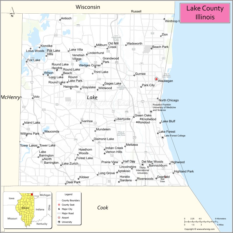
About Lake County Map, Illinois: The map showing the county boundary, county seat, major cities, highways, water bodies and neighbouring counties.
Most Viewed Illinois Links
Lake County, Illinois
Lake County is a county located in the U.S. state of Illinois. It's county seat is Waukegan. As per 2020 census, the population of Lake County is 711239 people and population density is square miles. According to the United States Census Bureau, the county has a total area of 443 sq mi (1,147 km2). Lake County was established on 1839.
Facts about Lake County, Illinois
| Country | United States |
| State | Illinois |
| Region | Northeastern Illinois |
| County Seat | Waukegan |
| Named After | Lake Michigan |
| Established | 1839 |
| Organized | 1839 |
| Coordinates | 42.33° N, 87.83° W |
| Total Area | ~1,368 sq mi |
| Land Area | ~444 sq mi |
| Water Area | ~924 sq mi |
| Population (2020) | ~714,342 |
| Population Rank | Third most populous county in Illinois |
| Largest City | Waukegan |
| Main Industries | Manufacturing, Healthcare, Technology, Defense, Retail |
| Major Water Body | Lake Michigan |
| Time Zone | Central Time (UTC−06:00) |
| Known For | Lake Michigan shoreline, forest preserves, Chicago suburbs |
| Website | https://www.lakecountyil.gov |
Ctities in Lake county
| City Name | Type | Population (2020) | Pop. Density | Area |
|---|---|---|---|---|
| Barrington | Village | 10,722 | 2,326.8/sq mi (898.4/km2) | 4.608 sq mi (11.93 km2) |
| Buffalo Grove | Village | 43,212 | 4,518.7/sq mi (1,744.7/km2) | 9.563 sq mi (24.77 km2) |
| Barrington Hills | Village | 4,114 | 152.3/sq mi (58.8/km2) | 27.004 sq mi (69.94 km2) |
| Antioch | Village | 14,622 | 1,780.3/sq mi (687.4/km2) | 8.213 sq mi (21.27 km2) |
| Bannockburn | Village | 1,013 | 499.5/sq mi (192.9/km2) | 2.028 sq mi (5.25 km2) |
| Beach Park | Village | 14,249 | 2,012.9/sq mi (777.2/km2) | 7.079 sq mi (18.33 km2) |
| Grayslake | Village | 21,248 | 1,949.4/sq mi (752.7/km2) | 10.9 sq mi (28.23 km2) |
| Green Oaks | Village | 4,128 | 1,035.9/sq mi (400.0/km2) | 3.985 sq mi (10.32 km2) |
| Gurnee | Village | 30,706 | 2,274.0/sq mi (878.0/km2) | 13.503 sq mi (34.97 km2) |
| Hainesville | Village | 3,546 | 1,919.9/sq mi (741.3/km2) | 1.847 sq mi (4.78 km2) |
| Hawthorn Woods | Village | 9,062 | 1,126.3/sq mi (434.9/km2) | 8.046 sq mi (20.84 km2) |
| Highland Park | City | 30,176 | 2,465.2/sq mi (951.8/km2) | 12.241 sq mi (31.7 km2) |
| Highwood | City | 5,074 | 7,037.4/sq mi (2,717.2/km2) | 0.721 sq mi (1.87 km2) |
| Indian Creek | Village | 536 | 2,007.5/sq mi (775.1/km2) | 0.267 sq mi (0.69 km2) |
| Kildeer | Village | 4,091 | 967.1/sq mi (373.4/km2) | 4.23 sq mi (10.96 km2) |
| Lake Barrington | Village | 5,100 | 889.1/sq mi (343.3/km2) | 5.736 sq mi (14.86 km2) |
| Lake Bluff | Village | 5,616 | 1,378.2/sq mi (532.1/km2) | 4.075 sq mi (10.55 km2) |
| Lake Forest | City | 19,367 | 1,126.0/sq mi (434.7/km2) | 17.2 sq mi (44.55 km2) |
| Lake Villa | Village | 8,741 | 1,341.7/sq mi (518.0/km2) | 6.515 sq mi (16.87 km2) |
| Lake Zurich | Village | 19,759 | 2,877.0/sq mi (1,110.8/km2) | 6.868 sq mi (17.79 km2) |
| Libertyville | Village | 20,579 | 2,336.4/sq mi (902.1/km2) | 8.808 sq mi (22.81 km2) |
| Lincolnshire | Village | 7,940 | 1,741.6/sq mi (672.4/km2) | 4.559 sq mi (11.81 km2) |
| Lindenhurst | Village | 14,406 | 3,182.2/sq mi (1,228.7/km2) | 4.527 sq mi (11.72 km2) |
| Long Grove | Village | 8,366 | 675.4/sq mi (260.8/km2) | 12.387 sq mi (32.08 km2) |
| Mettawa | Village | 533 | 97.8/sq mi (37.8/km2) | 5.449 sq mi (14.11 km2) |
| Mundelein | Village | 31,560 | 3,292.6/sq mi (1,271.3/km2) | 9.585 sq mi (24.83 km2) |
| North Barrington | Village | 3,171 | 673.0/sq mi (259.8/km2) | 4.712 sq mi (12.2 km2) |
| North Chicago | City | 30,759 | 3,848.2/sq mi (1,485.8/km2) | 7.993 sq mi (20.7 km2) |
| Old Mill Creek | Village | 162 | 15.2/sq mi (5.9/km2) | 10.671 sq mi (27.64 km2) |
| Park City | City | 7,885 | 6,815.0/sq mi (2,631.3/km2) | 1.157 sq mi (3 km2) |
| Riverwoods | Village | 3,790 | 955.4/sq mi (368.9/km2) | 3.967 sq mi (10.27 km2) |
| Round Lake | Village | 18,721 | 3,368.9/sq mi (1,300.7/km2) | 5.557 sq mi (14.39 km2) |
| Round Lake Beach | Village | 27,252 | 5,402.9/sq mi (2,086.1/km2) | 5.044 sq mi (13.06 km2) |
| Round Lake Heights | Village | 2,622 | 4,560.0/sq mi (1,760.6/km2) | 0.575 sq mi (1.49 km2) |
| Round Lake Park | Village | 7,680 | 3,722.7/sq mi (1,437.4/km2) | 2.063 sq mi (5.34 km2) |
| Third Lake | Village | 1,111 | 1,895.9/sq mi (732.0/km2) | 0.586 sq mi (1.52 km2) |
| Tower Lakes | Village | 1,226 | 1,334.1/sq mi (515.1/km2) | 0.919 sq mi (2.38 km2) |
| Vernon Hills | Village | 26,850 | 3,468.5/sq mi (1,339.2/km2) | 7.741 sq mi (20.05 km2) |
| Volo | Village | 6,122 | 1,563.7/sq mi (603.8/km2) | 3.915 sq mi (10.14 km2) |
| Wadsworth | Village | 3,517 | 356.8/sq mi (137.8/km2) | 9.857 sq mi (25.53 km2) |
| Wauconda | Village | 14,084 | 2,776.8/sq mi (1,072.1/km2) | 5.072 sq mi (13.14 km2) |
| Waukegan | City | 89,321 | 3,687.1/sq mi (1,423.6/km2) | 24.225 sq mi (62.74 km2) |
| Winthrop Harbor | Village | 6,705 | 1,446.0/sq mi (558.3/km2) | 4.637 sq mi (12.01 km2) |
| Zion | City | 24,655 | 2,489.4/sq mi (961.2/km2) | 9.904 sq mi (25.65 km2) |
| Deerfield | Village | 19,196 | 3,472.5/sq mi (1,340.7/km2) | 5.528 sq mi (14.32 km2) |
| Deer Park | Village | 3,681 | 1,007.4/sq mi (389.0/km2) | 3.654 sq mi (9.46 km2) |
| Fox Lake | Village | 10,978 | 1,401.5/sq mi (541.1/km2) | 7.833 sq mi (20.29 km2) |
| Island Lake | Village | 8,051 | 2,404.7/sq mi (928.5/km2) | 3.348 sq mi (8.67 km2) |
| Fox River Grove | Village | 4,702 | 2,748.1/sq mi (1,061.0/km2) | 1.711 sq mi (4.43 km2) |
| Lakemoor | Village | 6,182 | 1,174.6/sq mi (453.5/km2) | 5.263 sq mi (13.63 km2) |
| Port Barrington | Village | 1,584 | 1,365.5/sq mi (527.2/km2) | 1.16 sq mi (3 km2) |
Roads and Highways in Lake County, Illinois
Lake County is served by a dense network of highways that connect it to Chicago, Wisconsin, and the surrounding suburbs.
- Interstate 94 – runs north-south, connecting Waukegan to Chicago and Milwaukee
- Interstate 294 – runs along the western side, linking the county to Chicago’s western suburbs
- U.S. Route 41 – runs north-south along the Lake Michigan shoreline, connecting Waukegan to Chicago
- U.S. Route 45 – runs north-south, linking the county to Cook County and Wisconsin
- Illinois Route 120 – runs east-west, connecting Waukegan to McHenry and the Fox Lake area
- Illinois Route 132 – provides access to Gurnee and major shopping destinations
Neighboring Counties of Lake County
- McHenry County (west)
- Cook County (south)
- Kenosha County, Wisconsin (north)
Top Attractions in Lake County, Illinois
Lake County offers a mix of lakefront scenery, entertainment, shopping, and outdoor recreation.
- Six Flags Great America – A major amusement park with rides, shows, and family attractions.
- Illinois Beach State Park – Offers beaches, dunes, hiking trails, and scenic Lake Michigan views.
- Gurnee Mills – A large outlet shopping center with retail, dining, and entertainment options.
- Chain O’Lakes State Park – A popular destination for boating, fishing, and camping.
- Ravinia Festival – A well-known outdoor music venue hosting concerts and events.
- Volo Auto Museum – Features classic cars and unique exhibits.
- Waukegan Harbor and Marina – A scenic waterfront area with boating and lake views.
Distance from Lake County to Nearby Cities
- Waukegan to Chicago – 40 mi (64 km)
- Waukegan to Milwaukee – 55 mi (89 km)
- Waukegan to Rockford – 75 mi (121 km)
- Waukegan to Kenosha – 15 mi (24 km)
- Waukegan to Joliet – 70 mi (113 km)
FAQs about Lake County
Lake County is located in northeastern Illinois along Lake Michigan, north of Chicago.
The county is known for its lakefront attractions, amusement parks, shopping centers, and outdoor recreation.
Waukegan is the county seat and a major city in Lake County.
Yes, visitors can enjoy beaches, parks, lakes, trails, and outdoor recreation throughout the county.
Lake County is accessible via Interstates 94 and 294, U.S. Routes 41 and 45, and several Illinois state highways.
- Adams County Map
- Alexander County Map
- Bond County Map
- Boone County Map
- Brown County Map
- Bureau County Map
- Calhoun County Map
- Carroll County Map
- Cass County Map
- Champaign County Map
- Christian County Map
- Clark County Map
- Clay County Map
- Clinton County Map
- Coles County Map
- Cook County Map
- Crawford County Map
- Cumberland County Map
- DeKalb County Map
- DeWitt County Map
- Douglas County Map
- DuPage County Map
- Edgar County Map
- Edwards County Map
- Effingham County Map
- Fayette County Map
- Ford County Map
- Franklin County Map
- Fulton County Map
- Gallatin County Map
- Greene County Map
- Grundy County Map
- Hamilton County Map
- Hancock County Map
- Hardin County Map
- Henderson County Map
- Henry County Map
- Iroquois County Map
- Jackson County Map
- Jasper County Map
- Jefferson County Map
- Jersey County Map
- Jo Daviess County Map
- Johnson County Map
- Kane County Map
- Kankakee County Map
- Kendall County Map
- Knox County Map
- Lake County Map
- LaSalle County Map
- Lawrence County Map
- Lee County Map
- Livingston County Map
- Logan County Map
- McDonough County Map
- McHenry County Map
- McLean County Map
- Macon County Map
- Macoupin County Map
- Madison County Map
- Marion County Map
- Marshall County Map
- Mason County Map
- Massac County Map
- Menard County Map
- Mercer County Map
- Monroe County Map
- Montgomery County Map
- Morgan County Map
- Moultrie County Map
- Ogle County Map
- Peoria County Map
- Perry County Map
- Piatt County Map
- Pike County Map
- Pope County Map
- Pulaski County Map
- Putnam County Map
- Randolph County Map
- Richland County Map
- Rock Island County Map
- St Clair County Map
- Saline County Map
- Sangamon County Map
- Schuyler County Map
- Scott County Map
- Shelby County Map
- Stark County Map
- Stephenson County Map
- Tazewell County Map
- Union County Map
- Vermilion County Map
- Wabash County Map
- Warren County Map
- Washington County Map
- Wayne County Map
- White County Map
- Whiteside County Map
- Will County Map
- Williamson County Map
- Winnebago County Map
- Woodford County Map
- Alabama Counties
- Alaska boroughs
- Arizona Counties
- Arkansas Counties
- California County Map
- Colorado Counties
- Connecticut Counties
- Delaware Counties
- Florida County Map
- Georgia County Map
- Hawaii Counties
- Idaho Counties
- Illinois Counties
- Indiana Counties
- Iowa Counties
- Kansas Counties
- Kentucky Counties
- Louisiana Counties
- Maine Counties
- Maryland Counties
- Massachusetts Counties
- Michigan County Map
- Minnesota Counties
- Mississippi Counties
- Missouri Counties
- Montana Counties
- Nebraska Counties
- Nevada Counties
- New York Counties
- New Hampshire Counties
- New Jersey Counties
- New Mexico Counties
- North Carolina Counties
- North Dakota Counties
- Ohio County Map
- Oklahoma Counties
- Oregon Counties
- Pennsylvania Counties
- Rhode Island Counties
- South Carolina Counties
- South Dakota Counties
- Map of Tennessee
- Texas County Map
- Utah Counties
- Vermont Counties
- Virginia Counties
- Washington Counties
- West Virginia Counties
- Wisconsin Counties
- Wyoming Counties