Map of Rock Island County - Rock Island County is a county located in the U.S. state of Illinois. Rock Island County Map showing cities, highways, important places and water bodies. Get Where is Rock Island County located in the map, major cities in Rock Island county, population, areas, and places of interest.
Rock Island County Map, Illinois
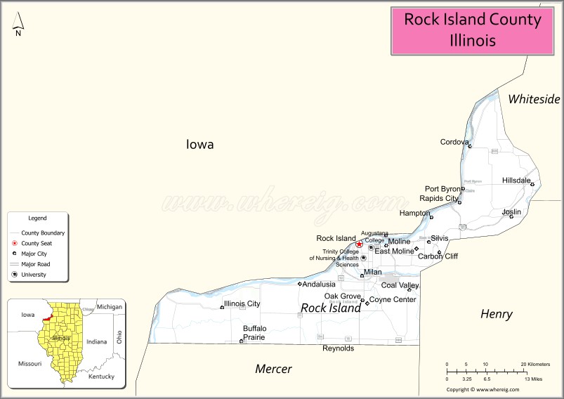
About Rock Island County Map, Illinois: The map showing the county boundary, county seat, major cities, highways, water bodies and neighbouring counties.
Most Viewed Illinois Links
Rock Island County, Illinois
Rock Island County is a county located in the U.S. state of Illinois. It's county seat is Rock Island. As per 2020 census, the population of Rock Island County is 142909 people and population density is square miles. According to the United States Census Bureau, the county has a total area of 427 sq mi (1,106 km2). Rock Island County was established on 1831.
Facts about Rock Island County, Illinois
| Country | United States |
| State | Illinois |
| Region | Northwestern Illinois / Quad Cities |
| County Seat | Rock Island |
| Named After | Rock Island (Mississippi River island) |
| Established | 1831 |
| Organized | 1831 |
| Coordinates | 41.47° N, 90.57° W |
| Total Area | ~451 sq mi |
| Land Area | ~428 sq mi |
| Water Area | ~23 sq mi |
| Population (2020) | ~144,672 |
| Population Rank | Seventh-most populous county in Illinois |
| Largest City | Moline |
| Main Industries | Manufacturing, Healthcare, Education, Logistics |
| Major Highways | Interstate 74, Interstate 280, U.S. Route 6 |
| Time Zone | Central Time (UTC−06:00) |
| Known For | Quad Cities, Mississippi River frontage, John Deere headquarters |
| Website | https://www.rockislandcountyil.gov |
Ctities in Rock county
| City Name | Type | Population (2020) | Pop. Density | Area | Incorporated |
|---|---|---|---|---|---|
| Andalusia | Village | 1,184 | 1,007.7/sq mi (389.1/km2) | 1.175 sq mi (3.04 km2) | |
| Carbon Cliff | Village | 1,846 | 881.1/sq mi (340.2/km2) | 2.095 sq mi (5.43 km2) | |
| Cordova | Village | 671 | 1,169.0/sq mi (451.3/km2) | 0.574 sq mi (1.49 km2) | |
| East Moline | City | 21,374 | 1,464.4/sq mi (565.4/km2) | 14.596 sq mi (37.8 km2) | |
| Hampton | Village | 1,779 | 1,217.7/sq mi (470.1/km2) | 1.461 sq mi (3.78 km2) | |
| Hillsdale | Village | 417 | 643.5/sq mi (248.5/km2) | 0.648 sq mi (1.68 km2) | |
| Milan | Village | 5,097 | 815.0/sq mi (314.7/km2) | 6.254 sq mi (16.2 km2) | |
| Moline | City | 42,985 | 2,565.8/sq mi (990.7/km2) | 16.753 sq mi (43.39 km2) | |
| Oak Grove | Village | 476 | 723.4/sq mi (279.3/km2) | 0.658 sq mi (1.7 km2) | |
| Port Byron | Village | 1,668 | 687.0/sq mi (265.2/km2) | 2.428 sq mi (6.29 km2) | |
| Rapids City | Village | 964 | 592.9/sq mi (228.9/km2) | 1.626 sq mi (4.21 km2) | |
| Rock Island | City | 37,108 | 2,199.4/sq mi (849.2/km2) | 16.872 sq mi (43.7 km2) | |
| Silvis | City | 8,003 | 1,867.7/sq mi (721.1/km2) | 4.285 sq mi (11.1 km2) | |
| Coal Valley | Village | 3,873 | 1,244.5/sq mi (480.5/km2) | 3.112 sq mi (8.06 km2) | |
| Reynolds | Village | 498 | 1,353.3/sq mi (522.5/km2) | 0.368 sq mi (0.95 km2) | |
| Atkinson | 7,087 | 11.2 sq mi | 1767 | ||
| Auburn | 5,946 | 25.2 sq mi | 1845 | ||
| Brentwood | 4,490 | 16.8 sq mi | 1742 | ||
| Candia | 4,013 | 30.3 sq mi | 1763 | ||
| Chester | 5,232 | 25.9 sq mi | 1722 | ||
| Danville | 4,408 | 11.7 sq mi | 1760 | ||
| Deerfield | 4,855 | 50.9 sq mi | 1766 | ||
| Derry | 34,317 | 35.6 sq mi | 1827 | ||
| East Kingston | 2,441 | 10 sq mi | 1738 | ||
| Epping | 7,125 | 26 sq mi | 1741 | ||
| Exeter | 16,049 | 19.6 sq mi | 1638 | ||
| Fremont | 4,739 | 17.2 sq mi | 1764 | ||
| Greenland | 4,067 | 10.5 sq mi | 1721 | ||
| Hampstead | 8,998 | 13.3 sq mi | 1749 | ||
| Hampton | 16,214 | 12.9 sq mi | 1639 | ||
| Hampton Falls | 2,403 | 12.2 sq mi | 1726 | ||
| Kensington | 2,095 | 11.9 sq mi | 1737 | ||
| Kingston | 6,202 | 19.7 sq mi | 1694 | ||
| Londonderry | 25,826 | 42 sq mi | 1722 | ||
| New Castle | 1,000 | 0.8 sq mi | 1693 | ||
| Newfields | 1,769 | 7 sq mi | 1849 | ||
| Newington | 811 | 8.2 sq mi | 1764 | ||
| Newmarket | 9,430 | 12.5 sq mi | 1727 | ||
| Newton | 4,820 | 9.9 sq mi | 1749 | ||
| North Hampton | 4,538 | 13.9 sq mi | 1742 | ||
| Northwood | 4,641 | 28 sq mi | 1773 | ||
| Nottingham | 5,229 | 46.5 sq mi | 1722 | ||
| Plaistow | 7,830 | 10.6 sq mi | 1749 | ||
| Portsmouth | 21,956 | 15.7 sq mi | 1631/1849 | ||
| Raymond | 10,684 | 28.8 sq mi | 1764 | ||
| Rye | 5,543 | 12.6 sq mi | 1726 | ||
| Salem | 30,089 | 24.7 sq mi | 1750 | ||
| Sandown | 6,548 | 13.9 sq mi | 1756 | ||
| Seabrook | 8,401 | 8.9 sq mi | 1768 | ||
| South Hampton | 894 | 7.9 sq mi | 1742 | ||
| Stratham | 7,669 | 15.1 sq mi | 1716 | ||
| Windham | 15,817 | 26.8 sq mi | 1742 |
Roads and Highways in Rock Island County, Illinois
Rock Island County is a major transportation hub in western Illinois, connecting the Quad Cities region with surrounding states.
- Interstate 74 – runs east-west through the county, connecting Moline to Davenport, Iowa and Galesburg
- Interstate 280 – serves as a bypass around the Quad Cities, linking Illinois and Iowa
- U.S. Route 6 – runs east-west, connecting Rock Island to Geneseo and Davenport
- U.S. Route 67 – runs north-south, linking Rock Island to Monmouth and Muscatine, Iowa
- Illinois Route 92 – runs east-west, connecting the county to Geneseo and Silvis
Neighboring Counties of Rock Island County
- Whiteside County (east)
- Henry County (south)
- Mercer County (southwest)
- Scott County, Iowa (north)
- Muscatine County, Iowa (west)
Top Attractions in Rock Island County, Illinois
Rock Island County offers a mix of riverfront scenery, cultural attractions, and urban amenities in the Quad Cities region.
- Rock Island Arsenal – A historic military installation and museum complex on the Mississippi River.
- Niabi Zoo – A family-friendly zoo with a variety of animal exhibits.
- Quad City Botanical Center – Features gardens, tropical plants, and educational exhibits.
- Mississippi Riverfront – Offers scenic views, parks, and walking trails.
- Figge Art Museum (nearby in Davenport) – A major regional art museum.
- Downtown Moline – Features shops, restaurants, and entertainment venues.
- TaxSlayer Center – Hosts concerts, sports events, and shows.
Distance from Rock Island County to Nearby Cities
- Moline to Davenport – 5 mi (8 km)
- Rock Island to Chicago – 170 mi (274 km)
- Moline to Peoria – 80 mi (129 km)
- Rock Island to Cedar Rapids – 90 mi (145 km)
- Moline to Springfield – 140 mi (225 km)
FAQs about Rock Island County
Rock Island County is located in western Illinois along the Mississippi River, part of the Quad Cities region.
The county is known for the Rock Island Arsenal, riverfront attractions, and its role in the Quad Cities metro area.
Rock Island is the county seat, while Moline is another major city in the county.
Yes, visitors can enjoy riverfront parks, trails, and outdoor recreation throughout the county.
Rock Island County is accessible via Interstates 74 and 280, U.S. Routes 6 and 67, and several Illinois state highways.
- Adams County Map
- Alexander County Map
- Bond County Map
- Boone County Map
- Brown County Map
- Bureau County Map
- Calhoun County Map
- Carroll County Map
- Cass County Map
- Champaign County Map
- Christian County Map
- Clark County Map
- Clay County Map
- Clinton County Map
- Coles County Map
- Cook County Map
- Crawford County Map
- Cumberland County Map
- DeKalb County Map
- DeWitt County Map
- Douglas County Map
- DuPage County Map
- Edgar County Map
- Edwards County Map
- Effingham County Map
- Fayette County Map
- Ford County Map
- Franklin County Map
- Fulton County Map
- Gallatin County Map
- Greene County Map
- Grundy County Map
- Hamilton County Map
- Hancock County Map
- Hardin County Map
- Henderson County Map
- Henry County Map
- Iroquois County Map
- Jackson County Map
- Jasper County Map
- Jefferson County Map
- Jersey County Map
- Jo Daviess County Map
- Johnson County Map
- Kane County Map
- Kankakee County Map
- Kendall County Map
- Knox County Map
- Lake County Map
- LaSalle County Map
- Lawrence County Map
- Lee County Map
- Livingston County Map
- Logan County Map
- McDonough County Map
- McHenry County Map
- McLean County Map
- Macon County Map
- Macoupin County Map
- Madison County Map
- Marion County Map
- Marshall County Map
- Mason County Map
- Massac County Map
- Menard County Map
- Mercer County Map
- Monroe County Map
- Montgomery County Map
- Morgan County Map
- Moultrie County Map
- Ogle County Map
- Peoria County Map
- Perry County Map
- Piatt County Map
- Pike County Map
- Pope County Map
- Pulaski County Map
- Putnam County Map
- Randolph County Map
- Richland County Map
- Rock Island County Map
- St Clair County Map
- Saline County Map
- Sangamon County Map
- Schuyler County Map
- Scott County Map
- Shelby County Map
- Stark County Map
- Stephenson County Map
- Tazewell County Map
- Union County Map
- Vermilion County Map
- Wabash County Map
- Warren County Map
- Washington County Map
- Wayne County Map
- White County Map
- Whiteside County Map
- Will County Map
- Williamson County Map
- Winnebago County Map
- Woodford County Map
- Alabama Counties
- Alaska boroughs
- Arizona Counties
- Arkansas Counties
- California County Map
- Colorado Counties
- Connecticut Counties
- Delaware Counties
- Florida County Map
- Georgia County Map
- Hawaii Counties
- Idaho Counties
- Illinois Counties
- Indiana Counties
- Iowa Counties
- Kansas Counties
- Kentucky Counties
- Louisiana Counties
- Maine Counties
- Maryland Counties
- Massachusetts Counties
- Michigan County Map
- Minnesota Counties
- Mississippi Counties
- Missouri Counties
- Montana Counties
- Nebraska Counties
- Nevada Counties
- New York Counties
- New Hampshire Counties
- New Jersey Counties
- New Mexico Counties
- North Carolina Counties
- North Dakota Counties
- Ohio County Map
- Oklahoma Counties
- Oregon Counties
- Pennsylvania Counties
- Rhode Island Counties
- South Carolina Counties
- South Dakota Counties
- Map of Tennessee
- Texas County Map
- Utah Counties
- Vermont Counties
- Virginia Counties
- Washington Counties
- West Virginia Counties
- Wisconsin Counties
- Wyoming Counties