Map of Stephenson County - Stephenson County is a county located in the U.S. state of Illinois. Stephenson County Map showing cities, highways, important places and water bodies. Get Where is Stephenson County located in the map, major cities in Stephenson county, population, areas, and places of interest.
Stephenson County Map, Illinois
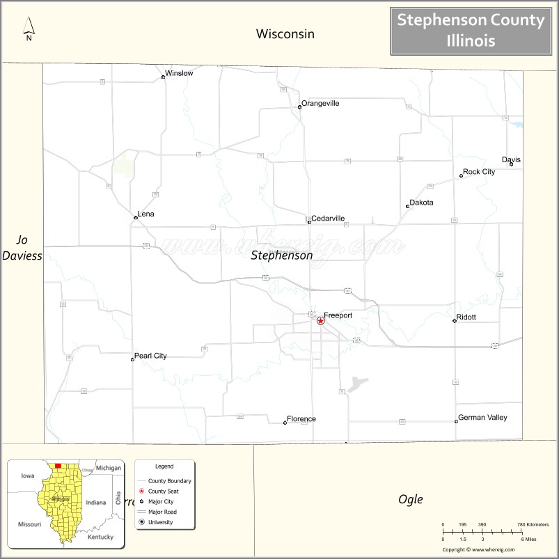
About Stephenson County Map, Illinois: The map showing the county boundary, county seat, major cities, highways, water bodies and neighbouring counties.
Most Viewed Illinois Links
Stephenson County, Illinois
Stephenson County is a county located in the U.S. state of Illinois. It's county seat is Freeport. As per 2020 census, the population of Stephenson County is 44021 people and population density is square miles. According to the United States Census Bureau, the county has a total area of 564 sq mi (1,461 km2). Stephenson County was established on 1837.
Facts about Stephenson County, Illinois
| Country | United States |
| State | Illinois |
| Region | Northwestern Illinois |
| County Seat | Freeport |
| Named After | Benjamin Stephenson |
| Established | 1837 |
| Organized | 1837 |
| Coordinates | 42.35° N, 89.65° W |
| Total Area | ~565 sq mi |
| Land Area | ~564 sq mi |
| Water Area | ~1 sq mi |
| Population (2020) | ~44,061 |
| Population Rank | Mid-sized county in Illinois |
| Largest City | Freeport |
| Main Industries | Manufacturing, Agriculture, Healthcare, Education |
| Major Highways | U.S. Route 20, Illinois Route 26 |
| Time Zone | Central Time (UTC−06:00) |
| Known For | Lincoln–Douglas Debate site, historic Freeport, rural landscape |
| Website | https://www.stephensoncountyil.gov |
Ctities in Stephenson county
| City Name | Type | Population (2020) | Pop. Density | Area |
|---|---|---|---|---|
| Cedarville | Village | 663 | 1,444.4/sq mi (557.7/km2) | 0.459 sq mi (1.19 km2) |
| Dakota | Village | 500 | 2,008.0/sq mi (775.3/km2) | 0.249 sq mi (0.64 km2) |
| Davis | Village | 589 | 1,454.3/sq mi (561.5/km2) | 0.405 sq mi (1.05 km2) |
| Freeport | City | 23,973 | 2,017.8/sq mi (779.1/km2) | 11.881 sq mi (30.77 km2) |
| German Valley | Village | 433 | 905.9/sq mi (349.8/km2) | 0.478 sq mi (1.24 km2) |
| Lena | Village | 2,772 | 1,045.6/sq mi (403.7/km2) | 2.651 sq mi (6.87 km2) |
| Orangeville | Village | 766 | 1,133.1/sq mi (437.5/km2) | 0.676 sq mi (1.75 km2) |
| Pearl City | Village | 790 | 1,232.4/sq mi (475.9/km2) | 0.641 sq mi (1.66 km2) |
| Ridott | Village | 124 | 1,675.7/sq mi (647.0/km2) | 0.074 sq mi (0.19 km2) |
| Rock City | Village | 293 | 2,186.6/sq mi (844.2/km2) | 0.134 sq mi (0.35 km2) |
| Winslow | Village | 281 | 613.5/sq mi (236.9/km2) | 0.458 sq mi (1.19 km2) |
Roads and Highways in Stephenson County, Illinois
Stephenson County is connected by major highways that provide access to northern Illinois and southern Wisconsin.
- U.S. Route 20 – runs east-west through the county, connecting Freeport to Rockford and Galena
- Illinois Route 26 – runs north-south, linking Freeport to Dixon and Monroe, Wisconsin
- Illinois Route 75 – runs east-west, connecting Freeport to Rockford and Stockton
- Illinois Route 73 – runs north-south, linking Lena to Freeport and Pearl City
Neighboring Counties of Stephenson County
- Jo Daviess County (west)
- Carroll County (southwest)
- Ogle County (southeast)
- Winnebago County (east)
- Green County, Wisconsin (north)
- Lafayette County, Wisconsin (northwest)
Top Attractions in Stephenson County, Illinois
Stephenson County offers historic sites, parks, and scenic landscapes centered around the city of Freeport.
- Lincoln-Douglas Debate Square – A historic site where Abraham Lincoln and Stephen Douglas debated.
- Krape Park – A scenic park with a lake, trails, and recreational facilities.
- Oakdale Nature Preserve – Offers hiking trails and nature viewing.
- Stephenson County Historical Society Museum – Highlights local history and heritage.
- Freeport Downtown Area – Features shops, dining, and historic architecture.
- Little Cubs Field – A replica baseball stadium for family-friendly games.
- Lake Le-Aqua-Na State Recreation Area (nearby) – Provides camping, fishing, and outdoor activities.
Distance from Stephenson County to Nearby Cities
- Freeport to Rockford – 25 mi (40 km)
- Freeport to Chicago – 115 mi (185 km)
- Freeport to Madison – 70 mi (113 km)
- Freeport to Dubuque – 70 mi (113 km)
- Freeport to Milwaukee – 120 mi (193 km)
FAQs about Stephenson County
Stephenson County is located in northwestern Illinois, near the Wisconsin border.
The county is known for its historic debate site, parks, and scenic countryside.
Freeport is the county seat and the largest city in Stephenson County.
Yes, visitors can enjoy parks, trails, lakes, and outdoor recreation throughout the county.
Stephenson County is accessible via U.S. Route 20 and several Illinois state highways.
- Adams County Map
- Alexander County Map
- Bond County Map
- Boone County Map
- Brown County Map
- Bureau County Map
- Calhoun County Map
- Carroll County Map
- Cass County Map
- Champaign County Map
- Christian County Map
- Clark County Map
- Clay County Map
- Clinton County Map
- Coles County Map
- Cook County Map
- Crawford County Map
- Cumberland County Map
- DeKalb County Map
- DeWitt County Map
- Douglas County Map
- DuPage County Map
- Edgar County Map
- Edwards County Map
- Effingham County Map
- Fayette County Map
- Ford County Map
- Franklin County Map
- Fulton County Map
- Gallatin County Map
- Greene County Map
- Grundy County Map
- Hamilton County Map
- Hancock County Map
- Hardin County Map
- Henderson County Map
- Henry County Map
- Iroquois County Map
- Jackson County Map
- Jasper County Map
- Jefferson County Map
- Jersey County Map
- Jo Daviess County Map
- Johnson County Map
- Kane County Map
- Kankakee County Map
- Kendall County Map
- Knox County Map
- Lake County Map
- LaSalle County Map
- Lawrence County Map
- Lee County Map
- Livingston County Map
- Logan County Map
- McDonough County Map
- McHenry County Map
- McLean County Map
- Macon County Map
- Macoupin County Map
- Madison County Map
- Marion County Map
- Marshall County Map
- Mason County Map
- Massac County Map
- Menard County Map
- Mercer County Map
- Monroe County Map
- Montgomery County Map
- Morgan County Map
- Moultrie County Map
- Ogle County Map
- Peoria County Map
- Perry County Map
- Piatt County Map
- Pike County Map
- Pope County Map
- Pulaski County Map
- Putnam County Map
- Randolph County Map
- Richland County Map
- Rock Island County Map
- St Clair County Map
- Saline County Map
- Sangamon County Map
- Schuyler County Map
- Scott County Map
- Shelby County Map
- Stark County Map
- Stephenson County Map
- Tazewell County Map
- Union County Map
- Vermilion County Map
- Wabash County Map
- Warren County Map
- Washington County Map
- Wayne County Map
- White County Map
- Whiteside County Map
- Will County Map
- Williamson County Map
- Winnebago County Map
- Woodford County Map
- Alabama Counties
- Alaska boroughs
- Arizona Counties
- Arkansas Counties
- California County Map
- Colorado Counties
- Connecticut Counties
- Delaware Counties
- Florida County Map
- Georgia County Map
- Hawaii Counties
- Idaho Counties
- Illinois Counties
- Indiana Counties
- Iowa Counties
- Kansas Counties
- Kentucky Counties
- Louisiana Counties
- Maine Counties
- Maryland Counties
- Massachusetts Counties
- Michigan County Map
- Minnesota Counties
- Mississippi Counties
- Missouri Counties
- Montana Counties
- Nebraska Counties
- Nevada Counties
- New York Counties
- New Hampshire Counties
- New Jersey Counties
- New Mexico Counties
- North Carolina Counties
- North Dakota Counties
- Ohio County Map
- Oklahoma Counties
- Oregon Counties
- Pennsylvania Counties
- Rhode Island Counties
- South Carolina Counties
- South Dakota Counties
- Map of Tennessee
- Texas County Map
- Utah Counties
- Vermont Counties
- Virginia Counties
- Washington Counties
- West Virginia Counties
- Wisconsin Counties
- Wyoming Counties