Map of Cass County - Cass County is a county located in the U.S. state of Illinois. Cass County Map showing cities, highways, important places and water bodies. Get Where is Cass County located in the map, major cities in Cass county, population, areas, and places of interest.
Cass County Map, Illinois
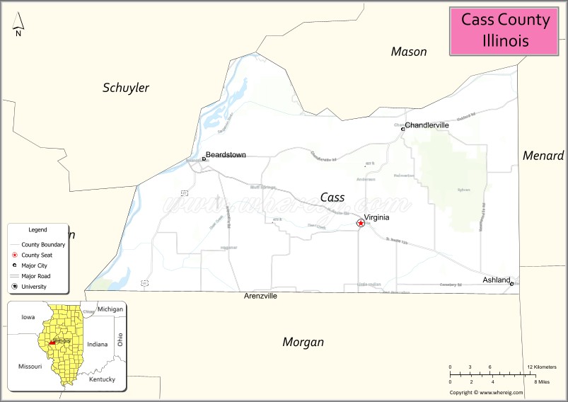
About Cass County Map, Illinois: The map showing the county boundary, county seat, major cities, highways, water bodies and neighbouring counties.
Most Viewed Illinois Links
Cass County, Illinois
Cass County is a county located in the U.S. state of Illinois. It's county seat is Virginia. As per 2020 census, the population of Cass County is 12773 people and population density is square miles. According to the United States Census Bureau, the county has a total area of 375 sq mi (971 km2). Cass County was established on 1837.
Facts about Cass County, Illinois
| Country | United States |
| State | Illinois |
| Region | West Central Illinois |
| County Seat | Virginia |
| Named After | Lewis Cass |
| Established | 1837 |
| Organized | 1837 |
| Coordinates | 39.97° N, 90.25° W |
| Total Area | ~376 sq mi |
| Land Area | ~375 sq mi |
| Water Area | ~1 sq mi |
| Population (2020) | ~12,062 |
| Population Rank | Small-sized county in Illinois |
| Largest City | Beardstown |
| Main Industries | Agriculture, Manufacturing, Food Processing |
| Major River | Illinois River |
| Time Zone | Central Time (UTC−06:00) |
| Known For | Illinois River commerce, rural farmland, historic river towns |
| Website | https://www.casscountyil.gov |
Ctities in Cass county
| City Name | Type | Population (2020) | Pop. Density | Area |
|---|---|---|---|---|
| Arenzville | Village | 367 | 477.9/sq mi (184.5/km2) | 0.768 sq mi (1.99 km2) |
| Ashland | Village | 1,218 | 1,628.3/sq mi (628.7/km2) | 0.748 sq mi (1.94 km2) |
| Beardstown | City | 5,951 | 1,644.4/sq mi (634.9/km2) | 3.619 sq mi (9.37 km2) |
| Chandlerville | Village | 527 | 663.7/sq mi (256.3/km2) | 0.794 sq mi (2.06 km2) |
| Virginia | City | 1,514 | 1,254.3/sq mi (484.3/km2) | 1.207 sq mi (3.13 km2) |
Roads and Highways in Cass County, Illinois
Cass County is served by several key highways that connect it to central Illinois and nearby river communities, making travel simple across the region.
- U.S. Route 67 – runs north-south through the county, connecting Beardstown to Jacksonville and Macomb
- Illinois Route 125 – runs east-west, linking Beardstown to Rushville and connecting to U.S. Route 24
- Illinois Route 78 – runs north-south through the eastern part of the county, connecting Virginia to Jacksonville
- Illinois Route 100 – runs along the Illinois River, connecting Beardstown to Havana and further south
Neighboring Counties of Cass County
- Morgan County (south)
- Schuyler County (west)
- Brown County (northwest)
- Mason County (northeast)
- Sangamon County (east)
Top Attractions in Cass County, Illinois
Cass County offers riverfront views, historic sites, and small-town charm centered around the city of Beardstown.
- Beardstown Historic District – A charming area with historic buildings and riverfront views.
- Lincoln Courtroom & Museum – Features the reconstructed courtroom where Abraham Lincoln practiced law.
- Illinois Riverfront Park – A relaxing area for walking, fishing, and enjoying river views.
- Chandlerville Heritage Museum – Showcases local history and community stories.
- Beardstown Marina – A popular spot for boating and fishing along the Illinois River.
- Virginia City Park – A community park with open green space and recreational facilities.
- Cass County Fairgrounds – Hosts local events and the annual county fair.
Distance from Cass County to Nearby Cities
- Beardstown to Jacksonville – 25 mi (40 km)
- Beardstown to Springfield – 45 mi (72 km)
- Beardstown to Peoria – 80 mi (129 km)
- Beardstown to Quincy – 70 mi (113 km)
- Beardstown to St. Louis – 120 mi (193 km)
FAQs about Cass County
Cass County is located in west-central Illinois along the Illinois River.
The county is known for its historic sites, riverfront areas, and connections to Abraham Lincoln’s legal career.
Virginia is the county seat, while Beardstown is the largest city in Cass County.
Yes, visitors can enjoy parks, riverfront areas, boating, and fishing along the Illinois River.
Cass County is accessible via U.S. Route 67 and several Illinois state highways including Routes 100, 125, and 78.
- Adams County Map
- Alexander County Map
- Bond County Map
- Boone County Map
- Brown County Map
- Bureau County Map
- Calhoun County Map
- Carroll County Map
- Cass County Map
- Champaign County Map
- Christian County Map
- Clark County Map
- Clay County Map
- Clinton County Map
- Coles County Map
- Cook County Map
- Crawford County Map
- Cumberland County Map
- DeKalb County Map
- DeWitt County Map
- Douglas County Map
- DuPage County Map
- Edgar County Map
- Edwards County Map
- Effingham County Map
- Fayette County Map
- Ford County Map
- Franklin County Map
- Fulton County Map
- Gallatin County Map
- Greene County Map
- Grundy County Map
- Hamilton County Map
- Hancock County Map
- Hardin County Map
- Henderson County Map
- Henry County Map
- Iroquois County Map
- Jackson County Map
- Jasper County Map
- Jefferson County Map
- Jersey County Map
- Jo Daviess County Map
- Johnson County Map
- Kane County Map
- Kankakee County Map
- Kendall County Map
- Knox County Map
- Lake County Map
- LaSalle County Map
- Lawrence County Map
- Lee County Map
- Livingston County Map
- Logan County Map
- McDonough County Map
- McHenry County Map
- McLean County Map
- Macon County Map
- Macoupin County Map
- Madison County Map
- Marion County Map
- Marshall County Map
- Mason County Map
- Massac County Map
- Menard County Map
- Mercer County Map
- Monroe County Map
- Montgomery County Map
- Morgan County Map
- Moultrie County Map
- Ogle County Map
- Peoria County Map
- Perry County Map
- Piatt County Map
- Pike County Map
- Pope County Map
- Pulaski County Map
- Putnam County Map
- Randolph County Map
- Richland County Map
- Rock Island County Map
- St Clair County Map
- Saline County Map
- Sangamon County Map
- Schuyler County Map
- Scott County Map
- Shelby County Map
- Stark County Map
- Stephenson County Map
- Tazewell County Map
- Union County Map
- Vermilion County Map
- Wabash County Map
- Warren County Map
- Washington County Map
- Wayne County Map
- White County Map
- Whiteside County Map
- Will County Map
- Williamson County Map
- Winnebago County Map
- Woodford County Map
- Alabama Counties
- Alaska boroughs
- Arizona Counties
- Arkansas Counties
- California County Map
- Colorado Counties
- Connecticut Counties
- Delaware Counties
- Florida County Map
- Georgia County Map
- Hawaii Counties
- Idaho Counties
- Illinois Counties
- Indiana Counties
- Iowa Counties
- Kansas Counties
- Kentucky Counties
- Louisiana Counties
- Maine Counties
- Maryland Counties
- Massachusetts Counties
- Michigan County Map
- Minnesota Counties
- Mississippi Counties
- Missouri Counties
- Montana Counties
- Nebraska Counties
- Nevada Counties
- New York Counties
- New Hampshire Counties
- New Jersey Counties
- New Mexico Counties
- North Carolina Counties
- North Dakota Counties
- Ohio County Map
- Oklahoma Counties
- Oregon Counties
- Pennsylvania Counties
- Rhode Island Counties
- South Carolina Counties
- South Dakota Counties
- Map of Tennessee
- Texas County Map
- Utah Counties
- Vermont Counties
- Virginia Counties
- Washington Counties
- West Virginia Counties
- Wisconsin Counties
- Wyoming Counties