Map of LaSalle County - LaSalle County is a county located in the U.S. state of Illinois. LaSalle County Map showing cities, highways, important places and water bodies. Get Where is LaSalle County located in the map, major cities in LaSalle county, population, areas, and places of interest.
LaSalle County Map, Illinois
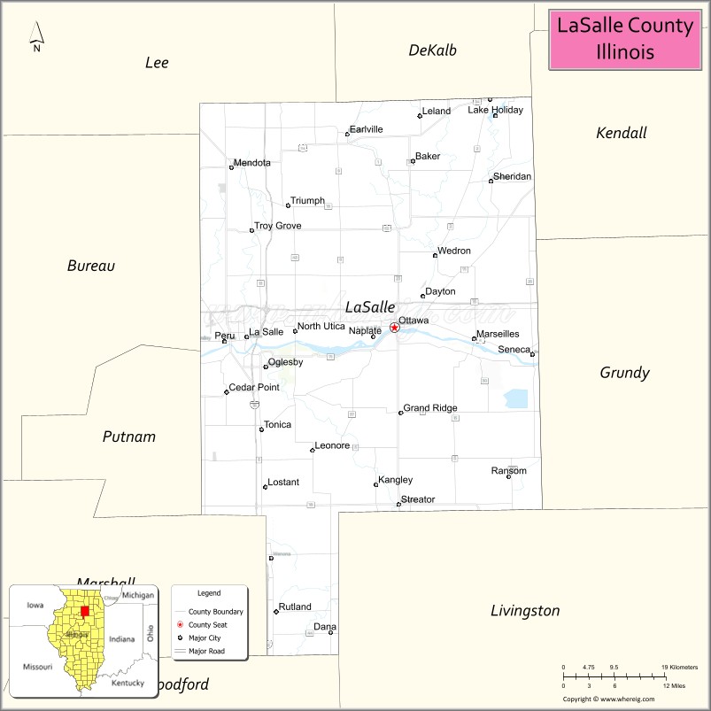
About LaSalle County Map, Illinois: The map showing the county boundary, county seat, major cities, highways, water bodies and neighbouring counties.
Most Viewed Illinois Links
LaSalle County, Illinois
LaSalle County is a county located in the U.S. state of Illinois. It's county seat is Ottawa. As per 2020 census, the population of LaSalle County is 108965 people and population density is square miles. According to the United States Census Bureau, the county has a total area of 1,135 sq mi (2,940 km2). LaSalle County was established on 1831.
Facts about LaSalle County, Illinois
| Country | United States |
| State | Illinois |
| Region | North Central Illinois |
| County Seat | Ottawa |
| Named After | René-Robert Cavelier, Sieur de La Salle |
| Established | 1831 |
| Organized | 1831 |
| Coordinates | 41.33° N, 88.90° W |
| Total Area | ~1,135 sq mi |
| Land Area | ~1,114 sq mi |
| Water Area | ~21 sq mi |
| Population (2020) | ~109,658 |
| Population Rank | One of the more populous counties in Illinois |
| Largest Cities | Ottawa, LaSalle, Peru |
| Main Industries | Manufacturing, Agriculture, Tourism, Healthcare |
| Major Rivers | Illinois River, Fox River, Vermilion River |
| Time Zone | Central Time (UTC−06:00) |
| Known For | Starved Rock State Park, canal history, river valleys |
| Website | https://www.lasallecounty.org |
Ctities in LaSalle county
| City Name | Type | Population (2020) | Pop. Density | Area |
|---|---|---|---|---|
| Somonauk | Village | 1,786 | 717.8/sq mi (277.2/km2) | 2.488 sq mi (6.44 km2) |
| Millington | Village | 617 | 871.5/sq mi (336.5/km2) | 0.708 sq mi (1.83 km2) |
| Cedar Point | Village | 266 | 260.5/sq mi (100.6/km2) | 1.021 sq mi (2.64 km2) |
| Dana | Village | 162 | 736.4/sq mi (284.3/km2) | 0.22 sq mi (0.57 km2) |
| Earlville | City | 1,613 | 1,343.0/sq mi (518.6/km2) | 1.201 sq mi (3.11 km2) |
| Grand Ridge | Village | 515 | 1,114.7/sq mi (430.4/km2) | 0.462 sq mi (1.2 km2) |
| Kangley | Village | 235 | 900.4/sq mi (347.6/km2) | 0.261 sq mi (0.68 km2) |
| LaSalle | City | 9,582 | 712.0/sq mi (274.9/km2) | 13.457 sq mi (34.85 km2) |
| Leland | Village | 951 | 1,780.9/sq mi (687.6/km2) | 0.534 sq mi (1.38 km2) |
| Leonore | Village | 121 | 1,359.6/sq mi (524.9/km2) | 0.089 sq mi (0.23 km2) |
| Lostant | Village | 423 | 377.0/sq mi (145.6/km2) | 1.122 sq mi (2.91 km2) |
| Marseilles | City | 4,845 | 533.6/sq mi (206.0/km2) | 9.08 sq mi (23.52 km2) |
| Mendota | City | 7,061 | 1,396.6/sq mi (539.2/km2) | 5.056 sq mi (13.09 km2) |
| Naplate | Village | 412 | 2,575.0/sq mi (994.2/km2) | 0.16 sq mi (0.41 km2) |
| North Utica | Village | 1,323 | 382.9/sq mi (147.8/km2) | 3.455 sq mi (8.95 km2) |
| Oglesby | City | 3,712 | 743.6/sq mi (287.1/km2) | 4.992 sq mi (12.93 km2) |
| Ottawa | City | 18,840 | 1,285.4/sq mi (496.3/km2) | 14.657 sq mi (37.96 km2) |
| Peru | City | 9,896 | 990.9/sq mi (382.6/km2) | 9.987 sq mi (25.87 km2) |
| Ransom | Village | 308 | 308.3/sq mi (119.0/km2) | 0.999 sq mi (2.59 km2) |
| Rutland | Village | 259 | 373.2/sq mi (144.1/km2) | 0.694 sq mi (1.8 km2) |
| Seneca | Village | 2,353 | 366.7/sq mi (141.6/km2) | 6.417 sq mi (16.62 km2) |
| Sheridan | Village | 2,431 | 1,146.2/sq mi (442.5/km2) | 2.121 sq mi (5.49 km2) |
| Tonica | Village | 749 | 549.5/sq mi (212.2/km2) | 1.363 sq mi (3.53 km2) |
| Troy Grove | Village | 225 | 327.5/sq mi (126.5/km2) | 0.687 sq mi (1.78 km2) |
| Streator | City | 12,500 | 1,714.0/sq mi (661.8/km2) | 7.293 sq mi (18.89 km2) |
Roads and Highways in LaSalle County, Illinois
LaSalle County is a major transportation hub with several interstates and highways connecting it to northern and central Illinois.
- Interstate 80 – runs east-west through the county, connecting Ottawa to Joliet and Peru
- Interstate 39 – runs north-south, linking LaSalle to Bloomington and Rockford
- U.S. Route 6 – parallels I-80, connecting Ottawa to Peru and surrounding areas
- U.S. Route 34 – runs east-west, linking Mendota to Princeton and Aurora
- Illinois Route 23 – runs north-south, connecting Ottawa to Streator and Marseilles
- Illinois Route 71 – runs east-west, linking Ottawa to Yorkville and Oswego
Neighboring Counties of LaSalle County
- DeKalb County (north)
- Kendall County (east)
- Grundy County (east)
- Livingston County (south)
- Marshall County (southwest)
- Bureau County (west)
- Putnam County (northwest)
Top Attractions in LaSalle County, Illinois
LaSalle County offers scenic parks, historic sites, and outdoor recreation along the Illinois River.
- Starved Rock State Park – A popular destination with canyons, waterfalls, and hiking trails.
- Matthiessen State Park – Known for rock formations, waterfalls, and scenic trails.
- Buffalo Rock State Park – Offers river views, trails, and outdoor activities.
- Illinois & Michigan Canal – A historic canal with trails for biking and walking.
- Reddick Mansion – A historic home showcasing local history and architecture.
- Downtown Ottawa – Features shops, dining, and riverfront views.
- Grand Bear Resort – A family-friendly destination near Starved Rock.
Distance from LaSalle County to Nearby Cities
- Ottawa to Chicago – 85 mi (137 km)
- Ottawa to Joliet – 50 mi (80 km)
- Ottawa to Bloomington – 70 mi (113 km)
- Ottawa to Peoria – 80 mi (129 km)
- Ottawa to Rockford – 90 mi (145 km)
FAQs about LaSalle County
LaSalle County is located in north-central Illinois, southwest of Chicago.
The county is known for Starved Rock State Park, scenic river landscapes, and outdoor recreation.
Ottawa is the county seat and a central city in LaSalle County.
Yes, visitors can enjoy hiking, parks, trails, and riverfront recreation throughout the county.
LaSalle County is accessible via Interstates 80 and 39, along with several U.S. and state highways.
- Adams County Map
- Alexander County Map
- Bond County Map
- Boone County Map
- Brown County Map
- Bureau County Map
- Calhoun County Map
- Carroll County Map
- Cass County Map
- Champaign County Map
- Christian County Map
- Clark County Map
- Clay County Map
- Clinton County Map
- Coles County Map
- Cook County Map
- Crawford County Map
- Cumberland County Map
- DeKalb County Map
- DeWitt County Map
- Douglas County Map
- DuPage County Map
- Edgar County Map
- Edwards County Map
- Effingham County Map
- Fayette County Map
- Ford County Map
- Franklin County Map
- Fulton County Map
- Gallatin County Map
- Greene County Map
- Grundy County Map
- Hamilton County Map
- Hancock County Map
- Hardin County Map
- Henderson County Map
- Henry County Map
- Iroquois County Map
- Jackson County Map
- Jasper County Map
- Jefferson County Map
- Jersey County Map
- Jo Daviess County Map
- Johnson County Map
- Kane County Map
- Kankakee County Map
- Kendall County Map
- Knox County Map
- Lake County Map
- LaSalle County Map
- Lawrence County Map
- Lee County Map
- Livingston County Map
- Logan County Map
- McDonough County Map
- McHenry County Map
- McLean County Map
- Macon County Map
- Macoupin County Map
- Madison County Map
- Marion County Map
- Marshall County Map
- Mason County Map
- Massac County Map
- Menard County Map
- Mercer County Map
- Monroe County Map
- Montgomery County Map
- Morgan County Map
- Moultrie County Map
- Ogle County Map
- Peoria County Map
- Perry County Map
- Piatt County Map
- Pike County Map
- Pope County Map
- Pulaski County Map
- Putnam County Map
- Randolph County Map
- Richland County Map
- Rock Island County Map
- St Clair County Map
- Saline County Map
- Sangamon County Map
- Schuyler County Map
- Scott County Map
- Shelby County Map
- Stark County Map
- Stephenson County Map
- Tazewell County Map
- Union County Map
- Vermilion County Map
- Wabash County Map
- Warren County Map
- Washington County Map
- Wayne County Map
- White County Map
- Whiteside County Map
- Will County Map
- Williamson County Map
- Winnebago County Map
- Woodford County Map
- Alabama Counties
- Alaska boroughs
- Arizona Counties
- Arkansas Counties
- California County Map
- Colorado Counties
- Connecticut Counties
- Delaware Counties
- Florida County Map
- Georgia County Map
- Hawaii Counties
- Idaho Counties
- Illinois Counties
- Indiana Counties
- Iowa Counties
- Kansas Counties
- Kentucky Counties
- Louisiana Counties
- Maine Counties
- Maryland Counties
- Massachusetts Counties
- Michigan County Map
- Minnesota Counties
- Mississippi Counties
- Missouri Counties
- Montana Counties
- Nebraska Counties
- Nevada Counties
- New York Counties
- New Hampshire Counties
- New Jersey Counties
- New Mexico Counties
- North Carolina Counties
- North Dakota Counties
- Ohio County Map
- Oklahoma Counties
- Oregon Counties
- Pennsylvania Counties
- Rhode Island Counties
- South Carolina Counties
- South Dakota Counties
- Map of Tennessee
- Texas County Map
- Utah Counties
- Vermont Counties
- Virginia Counties
- Washington Counties
- West Virginia Counties
- Wisconsin Counties
- Wyoming Counties