Map of Tazewell County - Tazewell County is a county located in the U.S. state of Illinois. Tazewell County Map showing cities, highways, important places and water bodies. Get Where is Tazewell County located in the map, major cities in Tazewell county, population, areas, and places of interest.
Tazewell County Map, Illinois
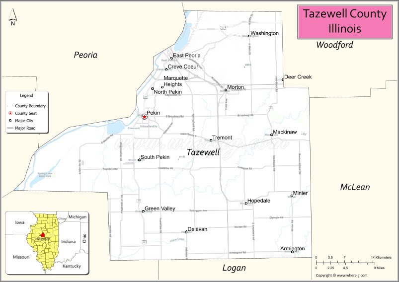
About Tazewell County Map, Illinois: The map showing the county boundary, county seat, major cities, highways, water bodies and neighbouring counties.
Most Viewed Illinois Links
Tazewell County, Illinois
Tazewell County is a county located in the U.S. state of Illinois. It's county seat is Pekin. As per 2020 census, the population of Tazewell County is 130413 people and population density is square miles. According to the United States Census Bureau, the county has a total area of 646 sq mi (1,673 km2). Tazewell County was established on 1827.
Facts about Tazewell County, Illinois
| Country | United States |
| State | Illinois |
| Region | Central Illinois |
| County Seat | Pekin |
| Named After | Littleton Waller Tazewell |
| Established | 1827 |
| Organized | 1827 |
| Coordinates | 40.51° N, 89.51° W |
| Total Area | ~649 sq mi |
| Land Area | ~646 sq mi |
| Water Area | ~3 sq mi |
| Population (2020) | ~131,803 |
| Population Rank | Eighth-most populous county in Illinois |
| Largest City | Pekin |
| Main Industries | Manufacturing, Healthcare, Agriculture, Logistics |
| Major Highways | Interstate 74, U.S. Route 24, Illinois Route 9 |
| Time Zone | Central Time (UTC−06:00) |
| Known For | Illinois River valley, Caterpillar facilities, suburban Peoria area |
| Website | https://www.tazewell.com |
Ctities in Tazewell county
| City Name | Type | Population (2020) | Pop. Density | Area |
|---|---|---|---|---|
| Armington | Village | 310 | 1,087.7/sq mi (420.0/km2) | 0.285 sq mi (0.74 km2) |
| Creve Coeur | Village | 4,934 | 1,166.2/sq mi (450.3/km2) | 4.231 sq mi (10.96 km2) |
| Deer Creek | Village | 667 | 1,246.7/sq mi (481.4/km2) | 0.535 sq mi (1.39 km2) |
| Delavan | City | 1,568 | 1,088.9/sq mi (420.4/km2) | 1.44 sq mi (3.73 km2) |
| East Peoria | City | 22,484 | 1,101.6/sq mi (425.3/km2) | 20.411 sq mi (52.86 km2) |
| Green Valley | Village | 630 | 2,093.0/sq mi (808.1/km2) | 0.301 sq mi (0.78 km2) |
| Hopedale | Village | 830 | 941.0/sq mi (363.3/km2) | 0.882 sq mi (2.28 km2) |
| Mackinaw | Village | 1,879 | 1,580.3/sq mi (610.2/km2) | 1.189 sq mi (3.08 km2) |
| Marquette Heights | City | 2,541 | 2,608.8/sq mi (1,007.3/km2) | 0.974 sq mi (2.52 km2) |
| Minier | Village | 1,154 | 2,028.1/sq mi (783.1/km2) | 0.569 sq mi (1.47 km2) |
| Morton | Village | 17,117 | 1,336.4/sq mi (516.0/km2) | 12.808 sq mi (33.17 km2) |
| North Pekin | Village | 1,478 | 1,061.8/sq mi (410.0/km2) | 1.392 sq mi (3.61 km2) |
| Pekin | City | 31,731 | 2,019.0/sq mi (779.5/km2) | 15.716 sq mi (40.7 km2) |
| South Pekin | Village | 996 | 1,934.0/sq mi (746.7/km2) | 0.515 sq mi (1.33 km2) |
| Tremont | Village | 2,277 | 2,033.0/sq mi (785.0/km2) | 1.12 sq mi (2.9 km2) |
| Washington | City | 16,071 | 1,881.6/sq mi (726.5/km2) | 8.541 sq mi (22.12 km2) |
| Goodfield | Village | 936 | 577.1/sq mi (222.8/km2) | 1.622 sq mi (4.2 km2) |
Roads and Highways in Tazewell County, Illinois
Tazewell County is a key transportation hub in central Illinois with multiple highways connecting it to nearby cities.
- Interstate 74 – runs east-west through the county, connecting East Peoria to Bloomington and Peoria
- Interstate 155 – runs north-south, linking Morton to Lincoln and central Illinois
- U.S. Route 24 – runs east-west, connecting Washington to Peoria and Eureka
- Illinois Route 9 – runs east-west, linking Pekin to Bloomington and Peoria
- Illinois Route 29 – runs north-south along the Illinois River, connecting Pekin to Peoria and Havana
Neighboring Counties of Tazewell County
- Woodford County (north)
- McLean County (east)
- DeWitt County (southeast)
- Logan County (south)
- Mason County (southwest)
- Peoria County (west)
Top Attractions in Tazewell County, Illinois
Tazewell County offers parks, riverfront views, and suburban communities near Peoria.
- Par-A-Dice Casino – A riverboat casino with gaming and entertainment.
- Fon du Lac Park District – Offers parks, trails, golf courses, and recreational facilities.
- Peoria Riverfront (nearby) – Provides scenic views, dining, and entertainment.
- Washington Park – A community park with recreational amenities.
- Tazewell County Courthouse – A historic landmark located in Pekin.
- Sunset Hills Golf Club – A popular golf destination.
- Avanti’s Dome – A sports and event complex for community activities.
Distance from Tazewell County to Nearby Cities
- Pekin to Peoria – 10 mi (16 km)
- East Peoria to Bloomington – 40 mi (64 km)
- Pekin to Springfield – 70 mi (113 km)
- East Peoria to Chicago – 165 mi (266 km)
- Pekin to Decatur – 75 mi (121 km)
FAQs about Tazewell County
Tazewell County is located in central Illinois, east of the Illinois River and adjacent to Peoria.
The county is known for its proximity to Peoria, parks, and riverfront attractions.
Pekin is the county seat and the largest city in Tazewell County.
Yes, visitors can enjoy parks, trails, golf courses, and outdoor recreation throughout the county.
Tazewell County is accessible via Interstates 74 and 155, along with several U.S. and state highways.
- Adams County Map
- Alexander County Map
- Bond County Map
- Boone County Map
- Brown County Map
- Bureau County Map
- Calhoun County Map
- Carroll County Map
- Cass County Map
- Champaign County Map
- Christian County Map
- Clark County Map
- Clay County Map
- Clinton County Map
- Coles County Map
- Cook County Map
- Crawford County Map
- Cumberland County Map
- DeKalb County Map
- DeWitt County Map
- Douglas County Map
- DuPage County Map
- Edgar County Map
- Edwards County Map
- Effingham County Map
- Fayette County Map
- Ford County Map
- Franklin County Map
- Fulton County Map
- Gallatin County Map
- Greene County Map
- Grundy County Map
- Hamilton County Map
- Hancock County Map
- Hardin County Map
- Henderson County Map
- Henry County Map
- Iroquois County Map
- Jackson County Map
- Jasper County Map
- Jefferson County Map
- Jersey County Map
- Jo Daviess County Map
- Johnson County Map
- Kane County Map
- Kankakee County Map
- Kendall County Map
- Knox County Map
- Lake County Map
- LaSalle County Map
- Lawrence County Map
- Lee County Map
- Livingston County Map
- Logan County Map
- McDonough County Map
- McHenry County Map
- McLean County Map
- Macon County Map
- Macoupin County Map
- Madison County Map
- Marion County Map
- Marshall County Map
- Mason County Map
- Massac County Map
- Menard County Map
- Mercer County Map
- Monroe County Map
- Montgomery County Map
- Morgan County Map
- Moultrie County Map
- Ogle County Map
- Peoria County Map
- Perry County Map
- Piatt County Map
- Pike County Map
- Pope County Map
- Pulaski County Map
- Putnam County Map
- Randolph County Map
- Richland County Map
- Rock Island County Map
- St Clair County Map
- Saline County Map
- Sangamon County Map
- Schuyler County Map
- Scott County Map
- Shelby County Map
- Stark County Map
- Stephenson County Map
- Tazewell County Map
- Union County Map
- Vermilion County Map
- Wabash County Map
- Warren County Map
- Washington County Map
- Wayne County Map
- White County Map
- Whiteside County Map
- Will County Map
- Williamson County Map
- Winnebago County Map
- Woodford County Map
- Alabama Counties
- Alaska boroughs
- Arizona Counties
- Arkansas Counties
- California County Map
- Colorado Counties
- Connecticut Counties
- Delaware Counties
- Florida County Map
- Georgia County Map
- Hawaii Counties
- Idaho Counties
- Illinois Counties
- Indiana Counties
- Iowa Counties
- Kansas Counties
- Kentucky Counties
- Louisiana Counties
- Maine Counties
- Maryland Counties
- Massachusetts Counties
- Michigan County Map
- Minnesota Counties
- Mississippi Counties
- Missouri Counties
- Montana Counties
- Nebraska Counties
- Nevada Counties
- New York Counties
- New Hampshire Counties
- New Jersey Counties
- New Mexico Counties
- North Carolina Counties
- North Dakota Counties
- Ohio County Map
- Oklahoma Counties
- Oregon Counties
- Pennsylvania Counties
- Rhode Island Counties
- South Carolina Counties
- South Dakota Counties
- Map of Tennessee
- Texas County Map
- Utah Counties
- Vermont Counties
- Virginia Counties
- Washington Counties
- West Virginia Counties
- Wisconsin Counties
- Wyoming Counties