Map of Edgar County - Edgar County is a county located in the U.S. state of Illinois. Edgar County Map showing cities, highways, important places and water bodies. Get Where is Edgar County located in the map, major cities in Edgar county, population, areas, and places of interest.
Edgar County Map, Illinois
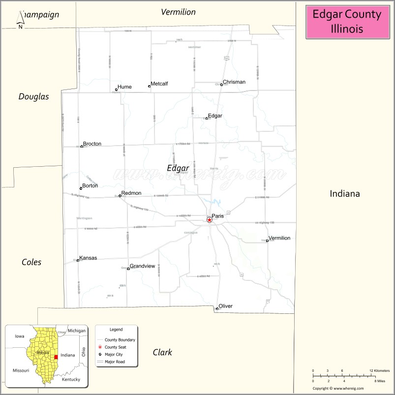
About Edgar County Map, Illinois: The map showing the county boundary, county seat, major cities, highways, water bodies and neighbouring counties.
Most Viewed Illinois Links
Edgar County, Illinois
Edgar County is a county located in the U.S. state of Illinois. It's county seat is Paris. As per 2020 census, the population of Edgar County is 16520 people and population density is square miles. According to the United States Census Bureau, the county has a total area of 623 sq mi (1,614 km2). Edgar County was established on 1823.
Facts about Edgar County, Illinois
| Country | United States |
| State | Illinois |
| Region | East Central Illinois |
| County Seat | Paris |
| Named After | John Edgar |
| Established | 1823 |
| Organized | 1823 |
| Coordinates | 39.68° N, 87.75° W |
| Total Area | ~623 sq mi |
| Land Area | ~622 sq mi |
| Water Area | ~1 sq mi |
| Population (2020) | ~16,925 |
| Population Rank | Small-to-mid-sized county in Illinois |
| Largest City | Paris |
| Main Industries | Agriculture, Manufacturing, Healthcare, Education |
| Major Highway | U.S. Route 150 |
| Time Zone | Central Time (UTC−06:00) |
| Known For | Paris–Edgar County Fair, rural farmland, historic communities |
| Website | https://www.edgarcountyillinois.com |
Ctities in Edgar county
| City Name | Type | Population (2020) | Pop. Density | Area |
|---|---|---|---|---|
| Brocton | Village | 273 | 477.3/sq mi (184.3/km2) | 0.572 sq mi (1.48 km2) |
| Chrisman | City | 1,312 | 1,824.8/sq mi (704.5/km2) | 0.719 sq mi (1.86 km2) |
| Hume | Village | 325 | 574.2/sq mi (221.7/km2) | 0.566 sq mi (1.47 km2) |
| Kansas | Village | 670 | 655.6/sq mi (253.1/km2) | 1.022 sq mi (2.65 km2) |
| Metcalf | Village | 139 | 234.0/sq mi (90.4/km2) | 0.594 sq mi (1.54 km2) |
| Paris | City | 8,291 | 1,460.7/sq mi (564.0/km2) | 5.676 sq mi (14.7 km2) |
| Redmon | Village | 137 | 944.8/sq mi (364.8/km2) | 0.145 sq mi (0.38 km2) |
| Vermilion | Village | 203 | 371.8/sq mi (143.6/km2) | 0.546 sq mi (1.41 km2) |
Roads and Highways in Edgar County, Illinois
Edgar County is connected by several key highways that provide access to eastern Illinois and neighboring Indiana.
- U.S. Route 150 – runs east-west through the county, connecting Paris to Champaign and Terre Haute
- Illinois Route 1 – runs north-south, linking Paris to Marshall and Lawrenceville
- Illinois Route 133 – connects Paris to Clinton and surrounding communities
- Illinois Route 16 – runs east-west, linking Paris to Charleston and Marshall
Neighboring Counties of Edgar County
- Vermilion County (north)
- Clark County (south)
- Coles County (west)
- Douglas County (northwest)
- Vigo County, Indiana (east)
Top Attractions in Edgar County, Illinois
Edgar County offers a mix of historic sites, small-town charm, and outdoor recreation centered around the city of Paris.
- Edgar County Courthouse – A historic landmark located in downtown Paris.
- Paris Twin Lakes Park – A popular park with lakes, trails, and picnic areas.
- Bicentennial Art Center – Features local art exhibits and cultural events.
- Edgar County Historical Society Museum – Showcases the county’s history and heritage.
- Sycamore Hills Golf Club – Offers a relaxing golf experience with scenic surroundings.
- Horizon Health Fitness Center Area – Provides recreational and wellness facilities.
- Downtown Paris Square – A charming area with shops, dining, and historic buildings.
Distance from Edgar County to Nearby Cities
- Paris to Terre Haute – 20 mi (32 km)
- Paris to Champaign – 55 mi (89 km)
- Paris to Charleston – 25 mi (40 km)
- Paris to Springfield – 120 mi (193 km)
- Paris to Indianapolis – 90 mi (145 km)
FAQs about Edgar County
Edgar County is located in eastern Illinois along the Indiana border.
The county is known for its historic town of Paris, parks, and local cultural attractions.
Paris is the county seat and the largest city in Edgar County.
Yes, visitors can enjoy parks, lakes, and outdoor recreational areas throughout the county.
Edgar County is accessible via U.S. Route 150 and several Illinois state highways including Routes 1, 133, and 16.
- Adams County Map
- Alexander County Map
- Bond County Map
- Boone County Map
- Brown County Map
- Bureau County Map
- Calhoun County Map
- Carroll County Map
- Cass County Map
- Champaign County Map
- Christian County Map
- Clark County Map
- Clay County Map
- Clinton County Map
- Coles County Map
- Cook County Map
- Crawford County Map
- Cumberland County Map
- DeKalb County Map
- DeWitt County Map
- Douglas County Map
- DuPage County Map
- Edgar County Map
- Edwards County Map
- Effingham County Map
- Fayette County Map
- Ford County Map
- Franklin County Map
- Fulton County Map
- Gallatin County Map
- Greene County Map
- Grundy County Map
- Hamilton County Map
- Hancock County Map
- Hardin County Map
- Henderson County Map
- Henry County Map
- Iroquois County Map
- Jackson County Map
- Jasper County Map
- Jefferson County Map
- Jersey County Map
- Jo Daviess County Map
- Johnson County Map
- Kane County Map
- Kankakee County Map
- Kendall County Map
- Knox County Map
- Lake County Map
- LaSalle County Map
- Lawrence County Map
- Lee County Map
- Livingston County Map
- Logan County Map
- McDonough County Map
- McHenry County Map
- McLean County Map
- Macon County Map
- Macoupin County Map
- Madison County Map
- Marion County Map
- Marshall County Map
- Mason County Map
- Massac County Map
- Menard County Map
- Mercer County Map
- Monroe County Map
- Montgomery County Map
- Morgan County Map
- Moultrie County Map
- Ogle County Map
- Peoria County Map
- Perry County Map
- Piatt County Map
- Pike County Map
- Pope County Map
- Pulaski County Map
- Putnam County Map
- Randolph County Map
- Richland County Map
- Rock Island County Map
- St Clair County Map
- Saline County Map
- Sangamon County Map
- Schuyler County Map
- Scott County Map
- Shelby County Map
- Stark County Map
- Stephenson County Map
- Tazewell County Map
- Union County Map
- Vermilion County Map
- Wabash County Map
- Warren County Map
- Washington County Map
- Wayne County Map
- White County Map
- Whiteside County Map
- Will County Map
- Williamson County Map
- Winnebago County Map
- Woodford County Map
- Alabama Counties
- Alaska boroughs
- Arizona Counties
- Arkansas Counties
- California County Map
- Colorado Counties
- Connecticut Counties
- Delaware Counties
- Florida County Map
- Georgia County Map
- Hawaii Counties
- Idaho Counties
- Illinois Counties
- Indiana Counties
- Iowa Counties
- Kansas Counties
- Kentucky Counties
- Louisiana Counties
- Maine Counties
- Maryland Counties
- Massachusetts Counties
- Michigan County Map
- Minnesota Counties
- Mississippi Counties
- Missouri Counties
- Montana Counties
- Nebraska Counties
- Nevada Counties
- New York Counties
- New Hampshire Counties
- New Jersey Counties
- New Mexico Counties
- North Carolina Counties
- North Dakota Counties
- Ohio County Map
- Oklahoma Counties
- Oregon Counties
- Pennsylvania Counties
- Rhode Island Counties
- South Carolina Counties
- South Dakota Counties
- Map of Tennessee
- Texas County Map
- Utah Counties
- Vermont Counties
- Virginia Counties
- Washington Counties
- West Virginia Counties
- Wisconsin Counties
- Wyoming Counties