Map of Woodford County - Woodford County is a county located in the U.S. state of Illinois. Woodford County Map showing cities, highways, important places and water bodies. Get Where is Woodford County located in the map, major cities in Woodford county, population, areas, and places of interest.
Woodford County Map, Illinois
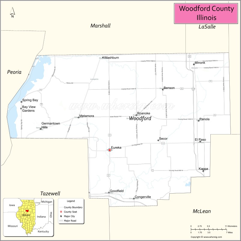
About Woodford County Map, Illinois: The map showing the county boundary, county seat, major cities, highways, water bodies and neighbouring counties.
Most Viewed Illinois Links
Woodford County, Illinois
Woodford County is a county located in the U.S. state of Illinois. It's county seat is Eureka. As per 2020 census, the population of Woodford County is 38225 people and population density is square miles. According to the United States Census Bureau, the county has a total area of 527 sq mi (1,365 km2). Woodford County was established on 1841.
Facts about Woodford County, Illinois
| Country | United States |
| State | Illinois |
| Region | Central Illinois |
| County Seat | Eureka |
| Named After | Woodford County, Kentucky |
| Established | 1841 |
| Organized | 1841 |
| Coordinates | 40.78° N, 89.22° W |
| Total Area | ~528 sq mi |
| Land Area | ~528 sq mi |
| Water Area | <1 sq mi |
| Population (2020) | ~38,664 |
| Population Rank | Mid-sized county in Illinois |
| Largest City | El Paso |
| Main Industries | Agriculture, Manufacturing, Healthcare |
| Major Highways | Interstate 39, Illinois Route 116 |
| Time Zone | Central Time (UTC−06:00) |
| Known For | Rural farmland, Eureka community, proximity to Bloomington–Normal |
| Website | https://www.woodfordcountyil.gov |
Ctities in Woodford county
| City Name | Type | Population (2020) | Pop. Density | Area |
|---|---|---|---|---|
| Peoria Heights | Village | 5,908 | 2,370.8/sq mi (915.4/km2) | 2.492 sq mi (6.45 km2) |
| Bay View Gardens | Village | 354 | 622.1/sq mi (240.2/km2) | 0.569 sq mi (1.47 km2) |
| Benson | Village | 412 | 2,527.6/sq mi (975.9/km2) | 0.163 sq mi (0.42 km2) |
| Congerville | Village | 497 | 516.1/sq mi (199.3/km2) | 0.963 sq mi (2.49 km2) |
| El Paso | City | 2,756 | 1,284.8/sq mi (496.1/km2) | 2.145 sq mi (5.56 km2) |
| Eureka | City | 5,227 | 1,947.5/sq mi (751.9/km2) | 2.684 sq mi (6.95 km2) |
| Germantown Hills | Village | 3,412 | 2,085.6/sq mi (805.2/km2) | 1.636 sq mi (4.24 km2) |
| Kappa | Village | 229 | 641.5/sq mi (247.7/km2) | 0.357 sq mi (0.92 km2) |
| Metamora | Village | 3,904 | 1,725.1/sq mi (666.1/km2) | 2.263 sq mi (5.86 km2) |
| Minonk | City | 1,928 | 803.3/sq mi (310.2/km2) | 2.4 sq mi (6.22 km2) |
| Panola | Village | 47 | 109.6/sq mi (42.3/km2) | 0.429 sq mi (1.11 km2) |
| Roanoke | Village | 1,960 | 2,087.3/sq mi (805.9/km2) | 0.939 sq mi (2.43 km2) |
| Secor | Village | 342 | 1,179.3/sq mi (455.3/km2) | 0.29 sq mi (0.75 km2) |
| Spring Bay | Village | 474 | 694.0/sq mi (268.0/km2) | 0.683 sq mi (1.77 km2) |
| Washburn | Village | 1,032 | 1,433.3/sq mi (553.4/km2) | 0.72 sq mi (1.86 km2) |
| Goodfield | Village | 936 | 577.1/sq mi (222.8/km2) | 1.622 sq mi (4.2 km2) |
Roads and Highways in Woodford County, Illinois
Woodford County is well-connected by highways that provide access to central Illinois and nearby cities.
- Interstate 39 – runs north-south through the county, connecting El Paso to Bloomington and LaSalle
- Interstate 74 – runs east-west, linking the county to Peoria and Bloomington
- U.S. Route 24 – runs east-west, connecting Eureka to Peoria and Washington
- Illinois Route 116 – runs east-west, linking Metamora to Pontiac and Farmington
- Illinois Route 117 – runs north-south, connecting Eureka to Goodfield and Roanoke
Neighboring Counties of Woodford County
- Marshall County (north)
- Livingston County (northeast)
- McLean County (east)
- Tazewell County (south)
- Peoria County (west)
Top Attractions in Woodford County, Illinois
Woodford County offers parks, historic sites, and small-town charm near the Peoria area.
- Eureka College – A historic college known for its connection to Ronald Reagan.
- Metamora Courthouse State Historic Site – A preserved 19th-century courthouse.
- Woodford County Courthouse – A historic landmark located in Eureka.
- Coal Hollow Park – Offers trails, playgrounds, and outdoor recreation.
- Roanoke Park District – Provides community parks and facilities.
- Metamora Downtown Area – Features shops, dining, and historic buildings.
- Woodford County Fairgrounds – Hosts fairs and community events.
Distance from Woodford County to Nearby Cities
- Eureka to Peoria – 20 mi (32 km)
- Metamora to Bloomington – 35 mi (56 km)
- Eureka to Springfield – 90 mi (145 km)
- Metamora to Chicago – 140 mi (225 km)
- Eureka to Champaign – 85 mi (137 km)
FAQs about Woodford County
Woodford County is located in central Illinois, northeast of Peoria.
The county is known for its historic sites, small towns, and proximity to Peoria.
Eureka is the county seat and a central community in Woodford County.
Yes, visitors can enjoy parks, trails, and outdoor recreation throughout the county.
Woodford County is accessible via Interstates 39 and 74, along with several U.S. and state highways.
- Adams County Map
- Alexander County Map
- Bond County Map
- Boone County Map
- Brown County Map
- Bureau County Map
- Calhoun County Map
- Carroll County Map
- Cass County Map
- Champaign County Map
- Christian County Map
- Clark County Map
- Clay County Map
- Clinton County Map
- Coles County Map
- Cook County Map
- Crawford County Map
- Cumberland County Map
- DeKalb County Map
- DeWitt County Map
- Douglas County Map
- DuPage County Map
- Edgar County Map
- Edwards County Map
- Effingham County Map
- Fayette County Map
- Ford County Map
- Franklin County Map
- Fulton County Map
- Gallatin County Map
- Greene County Map
- Grundy County Map
- Hamilton County Map
- Hancock County Map
- Hardin County Map
- Henderson County Map
- Henry County Map
- Iroquois County Map
- Jackson County Map
- Jasper County Map
- Jefferson County Map
- Jersey County Map
- Jo Daviess County Map
- Johnson County Map
- Kane County Map
- Kankakee County Map
- Kendall County Map
- Knox County Map
- Lake County Map
- LaSalle County Map
- Lawrence County Map
- Lee County Map
- Livingston County Map
- Logan County Map
- McDonough County Map
- McHenry County Map
- McLean County Map
- Macon County Map
- Macoupin County Map
- Madison County Map
- Marion County Map
- Marshall County Map
- Mason County Map
- Massac County Map
- Menard County Map
- Mercer County Map
- Monroe County Map
- Montgomery County Map
- Morgan County Map
- Moultrie County Map
- Ogle County Map
- Peoria County Map
- Perry County Map
- Piatt County Map
- Pike County Map
- Pope County Map
- Pulaski County Map
- Putnam County Map
- Randolph County Map
- Richland County Map
- Rock Island County Map
- St Clair County Map
- Saline County Map
- Sangamon County Map
- Schuyler County Map
- Scott County Map
- Shelby County Map
- Stark County Map
- Stephenson County Map
- Tazewell County Map
- Union County Map
- Vermilion County Map
- Wabash County Map
- Warren County Map
- Washington County Map
- Wayne County Map
- White County Map
- Whiteside County Map
- Will County Map
- Williamson County Map
- Winnebago County Map
- Woodford County Map
- Alabama Counties
- Alaska boroughs
- Arizona Counties
- Arkansas Counties
- California County Map
- Colorado Counties
- Connecticut Counties
- Delaware Counties
- Florida County Map
- Georgia County Map
- Hawaii Counties
- Idaho Counties
- Illinois Counties
- Indiana Counties
- Iowa Counties
- Kansas Counties
- Kentucky Counties
- Louisiana Counties
- Maine Counties
- Maryland Counties
- Massachusetts Counties
- Michigan County Map
- Minnesota Counties
- Mississippi Counties
- Missouri Counties
- Montana Counties
- Nebraska Counties
- Nevada Counties
- New York Counties
- New Hampshire Counties
- New Jersey Counties
- New Mexico Counties
- North Carolina Counties
- North Dakota Counties
- Ohio County Map
- Oklahoma Counties
- Oregon Counties
- Pennsylvania Counties
- Rhode Island Counties
- South Carolina Counties
- South Dakota Counties
- Map of Tennessee
- Texas County Map
- Utah Counties
- Vermont Counties
- Virginia Counties
- Washington Counties
- West Virginia Counties
- Wisconsin Counties
- Wyoming Counties