Map of Jo Daviess County - Jo Daviess County is a county located in the U.S. state of Illinois. Jo Daviess County Map showing cities, highways, important places and water bodies. Get Where is Jo Daviess County located in the map, major cities in Jo Daviess county, population, areas, and places of interest.
Jo Daviess County Map, Illinois
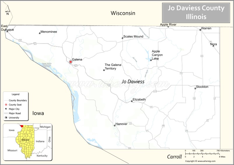
About Jo Daviess County Map, Illinois: The map showing the county boundary, county seat, major cities, highways, water bodies and neighbouring counties.
Most Viewed Illinois Links
Jo Daviess County, Illinois
Jo Daviess County is a county located in the U.S. state of Illinois. It's county seat is Galena. As per 2020 census, the population of Jo Daviess County is 21939 people and population density is square miles. According to the United States Census Bureau, the county has a total area of 600 sq mi (1,554 km2). Jo Daviess County was established on 1827.
Facts about Jo Daviess County, Illinois
| Country | United States |
| State | Illinois |
| Region | Northwestern Illinois |
| County Seat | Galena |
| Named After | Joseph Hamilton Daviess |
| Established | 1827 |
| Organized | 1831 |
| Coordinates | 42.36° N, 90.21° W |
| Total Area | ~601 sq mi |
| Land Area | ~599 sq mi |
| Water Area | ~2 sq mi |
| Population (2020) | ~22,035 |
| Population Rank | Small-to-mid-sized county in Illinois |
| Largest City | Galena |
| Main Industries | Tourism, Agriculture, Manufacturing |
| Major River | Mississippi River |
| Time Zone | Central Time (UTC−06:00) |
| Known For | Historic Galena, Ulysses S. Grant Home, rolling hills and tourism |
| Website | https://www.jodaviess.org |
Ctities in Jo Daviess county
| City Name | Type | Population (2020) | Pop. Density | Area |
|---|---|---|---|---|
| Apple River | Village | 347 | 492.2/sq mi (190.0/km2) | 0.705 sq mi (1.83 km2) |
| East Dubuque | City | 1,505 | 548.9/sq mi (211.9/km2) | 2.742 sq mi (7.1 km2) |
| Elizabeth | Village | 694 | 771.1/sq mi (297.7/km2) | 0.9 sq mi (2.33 km2) |
| Galena | City | 3,308 | 736.4/sq mi (284.3/km2) | 4.492 sq mi (11.63 km2) |
| Hanover | Village | 863 | 769.2/sq mi (297.0/km2) | 1.122 sq mi (2.91 km2) |
| Menominee | Village | 211 | 110.2/sq mi (42.6/km2) | 1.914 sq mi (4.96 km2) |
| Nora | Village | 107 | 128.9/sq mi (49.8/km2) | 0.83 sq mi (2.15 km2) |
| Scales Mound | Village | 436 | 694.3/sq mi (268.1/km2) | 0.628 sq mi (1.63 km2) |
| Stockton | Village | 1,728 | 920.6/sq mi (355.5/km2) | 1.877 sq mi (4.86 km2) |
| Warren | Village | 1,323 | 1,280.7/sq mi (494.5/km2) | 1.033 sq mi (2.68 km2) |
Roads and Highways in Jo Daviess County, Illinois
Jo Daviess County is served by scenic highways that connect it to northwestern Illinois, Iowa, and Wisconsin.
- U.S. Route 20 – runs east-west through the county, connecting Galena to Freeport and Dubuque, Iowa
- Illinois Route 84 – runs north-south along the Mississippi River, linking Galena to Savanna and Fulton
- Illinois Route 78 – runs north-south, connecting Stockton to Mount Carroll and Jacksonville
- Illinois Route 73 – connects Lena to Winslow and surrounding areas
Neighboring Counties of Jo Daviess County
- Stephenson County (east)
- Carroll County (south)
- Jackson County, Iowa (west)
- Dubuque County, Iowa (northwest)
- Lafayette County, Wisconsin (north)
Top Attractions in Jo Daviess County, Illinois
Jo Daviess County is known for its rolling hills, historic towns, and scenic beauty, especially around Galena.
- Galena Historic District – A charming area with preserved 19th-century buildings, shops, and restaurants.
- Ulysses S. Grant Home – The former home of the U.S. president, now a historic site.
- Chestnut Mountain Resort – A popular destination for skiing, zip-lining, and river views.
- Apple River Canyon State Park – Offers hiking, camping, and scenic natural landscapes.
- Dowling House – One of the oldest homes in Galena, showcasing early history.
- Galena River Trail – A scenic trail for walking, biking, and enjoying nature.
- Mississippi River Overlooks – Provide panoramic views of the river and surrounding countryside.
Distance from Jo Daviess County to Nearby Cities
- Galena to Dubuque – 15 mi (24 km)
- Galena to Freeport – 45 mi (72 km)
- Galena to Rockford – 80 mi (129 km)
- Galena to Madison – 90 mi (145 km)
- Galena to Chicago – 160 mi (257 km)
FAQs about Jo Daviess County
Jo Daviess County is located in northwestern Illinois, bordering Iowa and Wisconsin.
The county is known for Galena’s historic district, scenic hills, and outdoor recreation.
Galena is the county seat and a major tourist destination in Jo Daviess County.
Yes, visitors can enjoy hiking, skiing, river views, and scenic parks throughout the county.
Jo Daviess County is accessible via U.S. Route 20 and several Illinois state highways.
- Adams County Map
- Alexander County Map
- Bond County Map
- Boone County Map
- Brown County Map
- Bureau County Map
- Calhoun County Map
- Carroll County Map
- Cass County Map
- Champaign County Map
- Christian County Map
- Clark County Map
- Clay County Map
- Clinton County Map
- Coles County Map
- Cook County Map
- Crawford County Map
- Cumberland County Map
- DeKalb County Map
- DeWitt County Map
- Douglas County Map
- DuPage County Map
- Edgar County Map
- Edwards County Map
- Effingham County Map
- Fayette County Map
- Ford County Map
- Franklin County Map
- Fulton County Map
- Gallatin County Map
- Greene County Map
- Grundy County Map
- Hamilton County Map
- Hancock County Map
- Hardin County Map
- Henderson County Map
- Henry County Map
- Iroquois County Map
- Jackson County Map
- Jasper County Map
- Jefferson County Map
- Jersey County Map
- Jo Daviess County Map
- Johnson County Map
- Kane County Map
- Kankakee County Map
- Kendall County Map
- Knox County Map
- Lake County Map
- LaSalle County Map
- Lawrence County Map
- Lee County Map
- Livingston County Map
- Logan County Map
- McDonough County Map
- McHenry County Map
- McLean County Map
- Macon County Map
- Macoupin County Map
- Madison County Map
- Marion County Map
- Marshall County Map
- Mason County Map
- Massac County Map
- Menard County Map
- Mercer County Map
- Monroe County Map
- Montgomery County Map
- Morgan County Map
- Moultrie County Map
- Ogle County Map
- Peoria County Map
- Perry County Map
- Piatt County Map
- Pike County Map
- Pope County Map
- Pulaski County Map
- Putnam County Map
- Randolph County Map
- Richland County Map
- Rock Island County Map
- St Clair County Map
- Saline County Map
- Sangamon County Map
- Schuyler County Map
- Scott County Map
- Shelby County Map
- Stark County Map
- Stephenson County Map
- Tazewell County Map
- Union County Map
- Vermilion County Map
- Wabash County Map
- Warren County Map
- Washington County Map
- Wayne County Map
- White County Map
- Whiteside County Map
- Will County Map
- Williamson County Map
- Winnebago County Map
- Woodford County Map
- Alabama Counties
- Alaska boroughs
- Arizona Counties
- Arkansas Counties
- California County Map
- Colorado Counties
- Connecticut Counties
- Delaware Counties
- Florida County Map
- Georgia County Map
- Hawaii Counties
- Idaho Counties
- Illinois Counties
- Indiana Counties
- Iowa Counties
- Kansas Counties
- Kentucky Counties
- Louisiana Counties
- Maine Counties
- Maryland Counties
- Massachusetts Counties
- Michigan County Map
- Minnesota Counties
- Mississippi Counties
- Missouri Counties
- Montana Counties
- Nebraska Counties
- Nevada Counties
- New York Counties
- New Hampshire Counties
- New Jersey Counties
- New Mexico Counties
- North Carolina Counties
- North Dakota Counties
- Ohio County Map
- Oklahoma Counties
- Oregon Counties
- Pennsylvania Counties
- Rhode Island Counties
- South Carolina Counties
- South Dakota Counties
- Map of Tennessee
- Texas County Map
- Utah Counties
- Vermont Counties
- Virginia Counties
- Washington Counties
- West Virginia Counties
- Wisconsin Counties
- Wyoming Counties