Map of Peoria County - Peoria County is a county located in the U.S. state of Illinois. Peoria County Map showing cities, highways, important places and water bodies. Get Where is Peoria County located in the map, major cities in Peoria county, population, areas, and places of interest.
Peoria County Map, Illinois
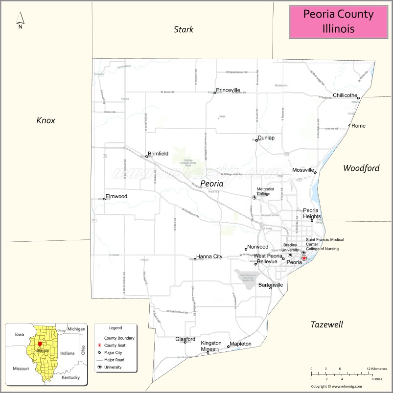
About Peoria County Map, Illinois: The map showing the county boundary, county seat, major cities, highways, water bodies and neighbouring counties.
Most Viewed Illinois Links
Peoria County, Illinois
Peoria County is a county located in the U.S. state of Illinois. It's county seat is Peoria. As per 2020 census, the population of Peoria County is 179432 people and population density is square miles. According to the United States Census Bureau, the county has a total area of 618 sq mi (1,601 km2). Peoria County was established on 1825.
Facts about Peoria County, Illinois
| Country | United States |
| State | Illinois |
| Region | Central Illinois |
| County Seat | Peoria |
| Named After | Peoria tribe |
| Established | 1825 |
| Organized | 1825 |
| Coordinates | 40.79° N, 89.76° W |
| Total Area | ~631 sq mi |
| Land Area | ~619 sq mi |
| Water Area | ~12 sq mi |
| Population (2020) | ~181,830 |
| Population Rank | Fourth-most populous county in Illinois |
| Largest City | Peoria |
| Main Industries | Manufacturing, Healthcare, Education, Logistics |
| Major Highways | Interstate 74, Interstate 474, U.S. Route 24 |
| Time Zone | Central Time (UTC−06:00) |
| Known For | Caterpillar headquarters, Illinois River bluffs, medical research |
| Website | https://www.peoriacounty.gov |
Ctities in Peoria county
| City Name | Type | Population (2020) | Pop. Density | Area |
|---|---|---|---|---|
| Bartonville | Village | 5,945 | 738.5/sq mi (285.1/km2) | 8.05 sq mi (20.85 km2) |
| Bellevue | Village | 1,878 | 844.4/sq mi (326.0/km2) | 2.224 sq mi (5.76 km2) |
| Brimfield | Village | 778 | 947.6/sq mi (365.9/km2) | 0.821 sq mi (2.13 km2) |
| Chillicothe | City | 6,128 | 1,161.9/sq mi (448.6/km2) | 5.274 sq mi (13.66 km2) |
| Dunlap | Village | 1,603 | 694.5/sq mi (268.2/km2) | 2.308 sq mi (5.98 km2) |
| Elmwood | City | 2,058 | 1,474.2/sq mi (569.2/km2) | 1.396 sq mi (3.62 km2) |
| Glasford | Village | 866 | 953.7/sq mi (368.2/km2) | 0.908 sq mi (2.35 km2) |
| Hanna City | Village | 1,253 | 980.4/sq mi (378.5/km2) | 1.278 sq mi (3.31 km2) |
| Kingston Mines | Village | 266 | 184.2/sq mi (71.1/km2) | 1.444 sq mi (3.74 km2) |
| Mapleton | Village | 261 | 294.9/sq mi (113.9/km2) | 0.885 sq mi (2.29 km2) |
| Norwood | Village | 437 | 1,423.5/sq mi (549.6/km2) | 0.307 sq mi (0.8 km2) |
| Peoria | City | 113,150 | 2,359.0/sq mi (910.8/km2) | 47.965 sq mi (124.23 km2) |
| Princeville | Village | 1,636 | 965.2/sq mi (372.7/km2) | 1.695 sq mi (4.39 km2) |
| West Peoria | City | 4,263 | 2,024.2/sq mi (781.6/km2) | 2.106 sq mi (5.45 km2) |
| Peoria Heights | Village | 5,908 | 2,370.8/sq mi (915.4/km2) | 2.492 sq mi (6.45 km2) |
Roads and Highways in Peoria County, Illinois
Peoria County is a major transportation hub in central Illinois with several highways connecting it to regional cities.
- Interstate 74 – runs east-west through the county, connecting Peoria to Bloomington and Galesburg
- U.S. Route 24 – runs east-west, linking Peoria to Washington and Lewistown
- U.S. Route 150 – runs east-west, connecting Peoria to Galesburg and Bloomington
- Illinois Route 6 – serves as a bypass around Peoria, connecting major highways
- Illinois Route 29 – runs north-south along the Illinois River, linking Peoria to Chillicothe and Pekin
- Illinois Route 40 – runs north-south, connecting Peoria to Lacon and Galesburg
Neighboring Counties of Peoria County
- Marshall County (north)
- Woodford County (east)
- Tazewell County (southeast)
- Fulton County (west)
- Knox County (northwest)
- Stark County (north)
Top Attractions in Peoria County, Illinois
Peoria County offers a mix of urban attractions, riverfront views, and cultural experiences centered around the city of Peoria.
- Peoria Riverfront Museum – Features exhibits on art, science, and history.
- Wildlife Prairie Park – A large park with native wildlife and outdoor activities.
- Peoria Zoo – A family-friendly attraction with animals from around the world.
- Grandview Drive – A scenic road with views of the Illinois River.
- Forest Park Nature Center – Offers trails and nature programs.
- Caterpillar Visitors Center – Highlights the history of the global equipment company.
- Downtown Peoria – Features dining, entertainment, and riverfront attractions.
Distance from Peoria County to Nearby Cities
- Peoria to Bloomington – 40 mi (64 km)
- Peoria to Springfield – 75 mi (121 km)
- Peoria to Chicago – 165 mi (266 km)
- Peoria to Galesburg – 50 mi (80 km)
- Peoria to Rockford – 130 mi (209 km)
FAQs about Peoria County
Peoria County is located in central Illinois along the Illinois River.
The county is known for its riverfront attractions, cultural institutions, and vibrant city of Peoria.
Peoria is the county seat and the largest city in Peoria County.
Yes, visitors can enjoy parks, trails, riverfront areas, and outdoor recreation throughout the county.
Peoria County is accessible via Interstate 74, U.S. Routes 24 and 150, and several Illinois state highways.
- Adams County Map
- Alexander County Map
- Bond County Map
- Boone County Map
- Brown County Map
- Bureau County Map
- Calhoun County Map
- Carroll County Map
- Cass County Map
- Champaign County Map
- Christian County Map
- Clark County Map
- Clay County Map
- Clinton County Map
- Coles County Map
- Cook County Map
- Crawford County Map
- Cumberland County Map
- DeKalb County Map
- DeWitt County Map
- Douglas County Map
- DuPage County Map
- Edgar County Map
- Edwards County Map
- Effingham County Map
- Fayette County Map
- Ford County Map
- Franklin County Map
- Fulton County Map
- Gallatin County Map
- Greene County Map
- Grundy County Map
- Hamilton County Map
- Hancock County Map
- Hardin County Map
- Henderson County Map
- Henry County Map
- Iroquois County Map
- Jackson County Map
- Jasper County Map
- Jefferson County Map
- Jersey County Map
- Jo Daviess County Map
- Johnson County Map
- Kane County Map
- Kankakee County Map
- Kendall County Map
- Knox County Map
- Lake County Map
- LaSalle County Map
- Lawrence County Map
- Lee County Map
- Livingston County Map
- Logan County Map
- McDonough County Map
- McHenry County Map
- McLean County Map
- Macon County Map
- Macoupin County Map
- Madison County Map
- Marion County Map
- Marshall County Map
- Mason County Map
- Massac County Map
- Menard County Map
- Mercer County Map
- Monroe County Map
- Montgomery County Map
- Morgan County Map
- Moultrie County Map
- Ogle County Map
- Peoria County Map
- Perry County Map
- Piatt County Map
- Pike County Map
- Pope County Map
- Pulaski County Map
- Putnam County Map
- Randolph County Map
- Richland County Map
- Rock Island County Map
- St Clair County Map
- Saline County Map
- Sangamon County Map
- Schuyler County Map
- Scott County Map
- Shelby County Map
- Stark County Map
- Stephenson County Map
- Tazewell County Map
- Union County Map
- Vermilion County Map
- Wabash County Map
- Warren County Map
- Washington County Map
- Wayne County Map
- White County Map
- Whiteside County Map
- Will County Map
- Williamson County Map
- Winnebago County Map
- Woodford County Map
- Alabama Counties
- Alaska boroughs
- Arizona Counties
- Arkansas Counties
- California County Map
- Colorado Counties
- Connecticut Counties
- Delaware Counties
- Florida County Map
- Georgia County Map
- Hawaii Counties
- Idaho Counties
- Illinois Counties
- Indiana Counties
- Iowa Counties
- Kansas Counties
- Kentucky Counties
- Louisiana Counties
- Maine Counties
- Maryland Counties
- Massachusetts Counties
- Michigan County Map
- Minnesota Counties
- Mississippi Counties
- Missouri Counties
- Montana Counties
- Nebraska Counties
- Nevada Counties
- New York Counties
- New Hampshire Counties
- New Jersey Counties
- New Mexico Counties
- North Carolina Counties
- North Dakota Counties
- Ohio County Map
- Oklahoma Counties
- Oregon Counties
- Pennsylvania Counties
- Rhode Island Counties
- South Carolina Counties
- South Dakota Counties
- Map of Tennessee
- Texas County Map
- Utah Counties
- Vermont Counties
- Virginia Counties
- Washington Counties
- West Virginia Counties
- Wisconsin Counties
- Wyoming Counties