Map of Kane County - Kane County is a county located in the U.S. state of Illinois. Kane County Map showing cities, highways, important places and water bodies. Get Where is Kane County located in the map, major cities in Kane county, population, areas, and places of interest.
Kane County Map, Illinois
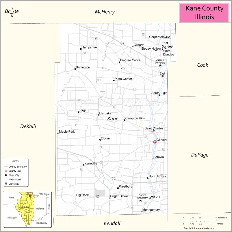
About Kane County Map, Illinois: The map showing the county boundary, county seat, major cities, highways, water bodies and neighbouring counties.
Most Viewed Illinois Links
Kane County, Illinois
Kane County is a county located in the U.S. state of Illinois. It's county seat is Geneva. As per 2020 census, the population of Kane County is 515588 people and population density is square miles. According to the United States Census Bureau, the county has a total area of 519 sq mi (1,344 km2). Kane County was established on 1836.
Facts about Kane County, Illinois
| Country | United States |
| State | Illinois |
| Region | Northeastern Illinois |
| County Seat | Geneva |
| Named After | Elias Kane |
| Established | 1836 |
| Organized | 1836 |
| Coordinates | 41.94° N, 88.43° W |
| Total Area | ~524 sq mi |
| Land Area | ~521 sq mi |
| Water Area | ~3 sq mi |
| Population (2020) | ~516,522 |
| Population Rank | One of the most populous counties in Illinois |
| Largest Cities | Aurora, Elgin |
| Main Industries | Manufacturing, Healthcare, Education, Retail, Technology |
| Major River | Fox River |
| Time Zone | Central Time (UTC−06:00) |
| Known For | Fox River Valley, Chicago suburbs, historic downtowns |
| Website | https://www.countyofkane.org |
Ctities in Kane county
| City Name | Type | Population (2020) | Pop. Density | Area |
|---|---|---|---|---|
| Bartlett | Village | 41,105 | 2,613.8/sq mi (1,009.2/km2) | 15.726 sq mi (40.73 km2) |
| Barrington Hills | Village | 4,114 | 152.3/sq mi (58.8/km2) | 27.004 sq mi (69.94 km2) |
| Wayne | Village | 2,286 | 399.0/sq mi (154.0/km2) | 5.73 sq mi (14.84 km2) |
| Batavia | City | 26,098 | 2,458.4/sq mi (949.2/km2) | 10.616 sq mi (27.5 km2) |
| Big Rock | Village | 1,104 | 255.7/sq mi (98.7/km2) | 4.318 sq mi (11.18 km2) |
| Burlington | Village | 535 | 78.0/sq mi (30.1/km2) | 6.855 sq mi (17.75 km2) |
| Campton Hills | Village | 10,885 | 644.5/sq mi (248.8/km2) | 16.89 sq mi (43.74 km2) |
| Carpentersville | Village | 37,983 | 4,818.3/sq mi (1,860.4/km2) | 7.883 sq mi (20.42 km2) |
| Elburn | Village | 6,175 | 1,711.5/sq mi (660.8/km2) | 3.608 sq mi (9.34 km2) |
| Geneva | City | 21,393 | 2,156.8/sq mi (832.7/km2) | 9.919 sq mi (25.69 km2) |
| Gilberts | Village | 8,366 | 1,524.1/sq mi (588.5/km2) | 5.489 sq mi (14.22 km2) |
| Hampshire | Village | 7,667 | 806.6/sq mi (311.4/km2) | 9.505 sq mi (24.62 km2) |
| Kaneville | Village | 452 | 1,586.0/sq mi (612.3/km2) | 0.285 sq mi (0.74 km2) |
| Lily Lake | Village | 1,032 | 379.8/sq mi (146.7/km2) | 2.717 sq mi (7.04 km2) |
| North Aurora | Village | 18,261 | 2,416.4/sq mi (933.0/km2) | 7.557 sq mi (19.57 km2) |
| Pingree Grove | Village | 10,365 | 2,849.9/sq mi (1,100.3/km2) | 3.637 sq mi (9.42 km2) |
| Sleepy Hollow | Village | 3,214 | 1,591.9/sq mi (614.6/km2) | 2.019 sq mi (5.23 km2) |
| South Elgin | Village | 23,865 | 3,380.3/sq mi (1,305.1/km2) | 7.06 sq mi (18.29 km2) |
| Sugar Grove | Village | 9,278 | 789.8/sq mi (304.9/km2) | 11.748 sq mi (30.43 km2) |
| Virgil | Village | 289 | 132.4/sq mi (51.1/km2) | 2.183 sq mi (5.65 km2) |
| West Dundee | Village | 7,686 | 2,113.3/sq mi (815.9/km2) | 3.637 sq mi (9.42 km2) |
| East Dundee | Village | 3,152 | 1,110.3/sq mi (428.7/km2) | 2.839 sq mi (7.35 km2) |
| Elgin | City | 114,797 | 3,018.8/sq mi (1,165.6/km2) | 38.027 sq mi (98.49 km2) |
| Maple Park | Village | 1,433 | 665.3/sq mi (256.9/km2) | 2.154 sq mi (5.58 km2) |
| St. Charles | City | 33,081 | 2,297.1/sq mi (886.9/km2) | 14.401 sq mi (37.3 km2) |
| Aurora | City | 180,542 | 4,010.0/sq mi (1,548.3/km2) | 45.023 sq mi (116.61 km2) |
| Montgomery | Village | 20,262 | 2,178.9/sq mi (841.3/km2) | 9.299 sq mi (24.08 km2) |
| Algonquin | Village | 29,700 | 2,414.2/sq mi (932.1/km2) | 12.302 sq mi (31.86 km2) |
| Huntley | Village | 27,740 | 1,941.4/sq mi (749.6/km2) | 14.289 sq mi (37.01 km2) |
Roads and Highways in Kane County, Illinois
Kane County is well-connected by major highways that link it to Chicago and the western suburbs.
- Interstate 88 – runs east-west through the county, connecting Aurora to Chicago and the Quad Cities
- U.S. Route 20 – runs east-west, linking Elgin to Rockford and Chicago
- Illinois Route 31 – runs north-south along the Fox River, connecting Elgin, Geneva, and Aurora
- Illinois Route 25 – parallels Route 31, linking several Fox River communities
- Illinois Route 47 – runs north-south, connecting Huntley to Sugar Grove and beyond
Neighboring Counties of Kane County
- McHenry County (north)
- Cook County (east)
- DuPage County (southeast)
- Kendall County (south)
- DeKalb County (west)
Top Attractions in Kane County, Illinois
Kane County offers a mix of suburban attractions, historic sites, and outdoor recreation along the Fox River.
- Fabyan Forest Preserve – Features trails, gardens, and a historic windmill.
- Chicago Premium Outlets – A popular shopping destination in Aurora.
- Elgin Public Museum – Showcases natural history and local exhibits.
- Fox River Trail – A scenic path for biking and walking along the river.
- Arcada Theatre – A historic venue hosting concerts and live performances.
- Geneva Historic District – Known for charming shops, dining, and historic buildings.
- Kane County Fairgrounds – Hosts events, markets, and the annual county fair.
Distance from Kane County to Nearby Cities
- Aurora to Chicago – 40 mi (64 km)
- Elgin to Rockford – 60 mi (97 km)
- Aurora to Naperville – 10 mi (16 km)
- Elgin to Waukegan – 40 mi (64 km)
- Aurora to Joliet – 35 mi (56 km)
FAQs about Kane County
Kane County is located in northeastern Illinois, west of Chicago.
The county is known for its Fox River communities, parks, shopping areas, and historic districts.
Geneva is the county seat of Kane County.
Yes, visitors can enjoy forest preserves, trails, and riverfront recreation throughout the county.
Kane County is accessible via Interstate 88, U.S. Route 20, and several Illinois state highways.
- Adams County Map
- Alexander County Map
- Bond County Map
- Boone County Map
- Brown County Map
- Bureau County Map
- Calhoun County Map
- Carroll County Map
- Cass County Map
- Champaign County Map
- Christian County Map
- Clark County Map
- Clay County Map
- Clinton County Map
- Coles County Map
- Cook County Map
- Crawford County Map
- Cumberland County Map
- DeKalb County Map
- DeWitt County Map
- Douglas County Map
- DuPage County Map
- Edgar County Map
- Edwards County Map
- Effingham County Map
- Fayette County Map
- Ford County Map
- Franklin County Map
- Fulton County Map
- Gallatin County Map
- Greene County Map
- Grundy County Map
- Hamilton County Map
- Hancock County Map
- Hardin County Map
- Henderson County Map
- Henry County Map
- Iroquois County Map
- Jackson County Map
- Jasper County Map
- Jefferson County Map
- Jersey County Map
- Jo Daviess County Map
- Johnson County Map
- Kane County Map
- Kankakee County Map
- Kendall County Map
- Knox County Map
- Lake County Map
- LaSalle County Map
- Lawrence County Map
- Lee County Map
- Livingston County Map
- Logan County Map
- McDonough County Map
- McHenry County Map
- McLean County Map
- Macon County Map
- Macoupin County Map
- Madison County Map
- Marion County Map
- Marshall County Map
- Mason County Map
- Massac County Map
- Menard County Map
- Mercer County Map
- Monroe County Map
- Montgomery County Map
- Morgan County Map
- Moultrie County Map
- Ogle County Map
- Peoria County Map
- Perry County Map
- Piatt County Map
- Pike County Map
- Pope County Map
- Pulaski County Map
- Putnam County Map
- Randolph County Map
- Richland County Map
- Rock Island County Map
- St Clair County Map
- Saline County Map
- Sangamon County Map
- Schuyler County Map
- Scott County Map
- Shelby County Map
- Stark County Map
- Stephenson County Map
- Tazewell County Map
- Union County Map
- Vermilion County Map
- Wabash County Map
- Warren County Map
- Washington County Map
- Wayne County Map
- White County Map
- Whiteside County Map
- Will County Map
- Williamson County Map
- Winnebago County Map
- Woodford County Map
- Alabama Counties
- Alaska boroughs
- Arizona Counties
- Arkansas Counties
- California County Map
- Colorado Counties
- Connecticut Counties
- Delaware Counties
- Florida County Map
- Georgia County Map
- Hawaii Counties
- Idaho Counties
- Illinois Counties
- Indiana Counties
- Iowa Counties
- Kansas Counties
- Kentucky Counties
- Louisiana Counties
- Maine Counties
- Maryland Counties
- Massachusetts Counties
- Michigan County Map
- Minnesota Counties
- Mississippi Counties
- Missouri Counties
- Montana Counties
- Nebraska Counties
- Nevada Counties
- New York Counties
- New Hampshire Counties
- New Jersey Counties
- New Mexico Counties
- North Carolina Counties
- North Dakota Counties
- Ohio County Map
- Oklahoma Counties
- Oregon Counties
- Pennsylvania Counties
- Rhode Island Counties
- South Carolina Counties
- South Dakota Counties
- Map of Tennessee
- Texas County Map
- Utah Counties
- Vermont Counties
- Virginia Counties
- Washington Counties
- West Virginia Counties
- Wisconsin Counties
- Wyoming Counties