Map of Henry County - Henry County is a county located in the U.S. state of Illinois. Henry County Map showing cities, highways, important places and water bodies. Get Where is Henry County located in the map, major cities in Henry county, population, areas, and places of interest.
Henry County Map, Illinois
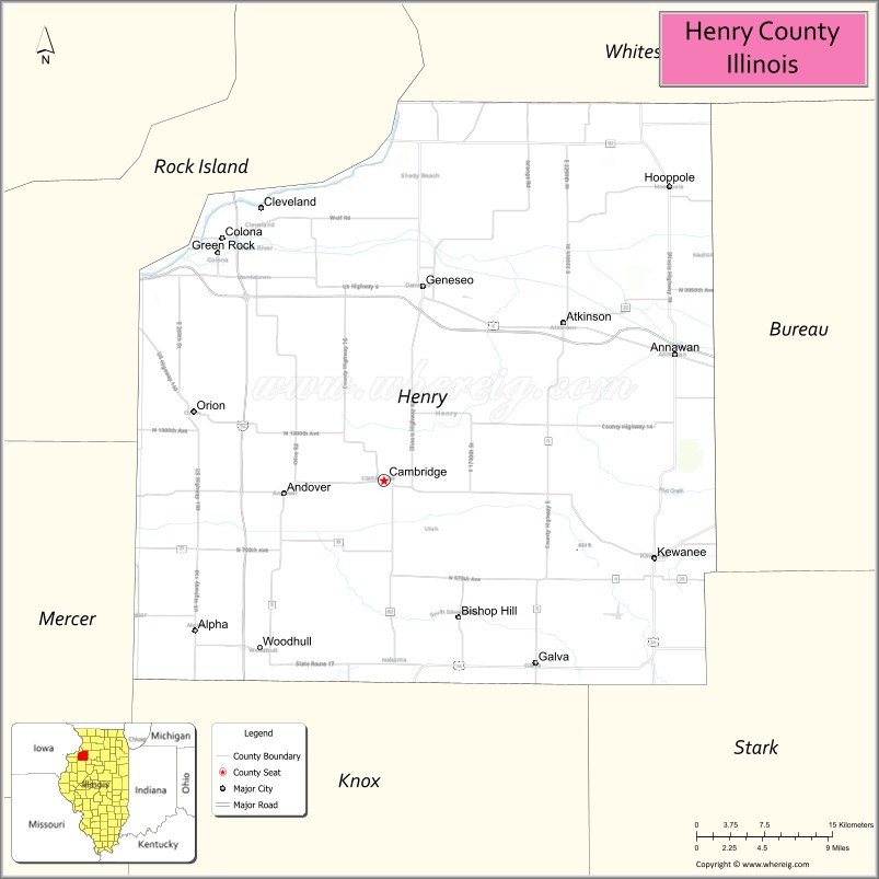
About Henry County Map, Illinois: The map showing the county boundary, county seat, major cities, highways, water bodies and neighbouring counties.
Most Viewed Illinois Links
Henry County, Illinois
Henry County is a county located in the U.S. state of Illinois. It's county seat is Cambridge. As per 2020 census, the population of Henry County is 48907 people and population density is square miles. According to the United States Census Bureau, the county has a total area of 822 sq mi (2,129 km2). Henry County was established on 1825.
Facts about Henry County, Illinois
| Country | United States |
| State | Illinois |
| Region | Northwestern Illinois |
| County Seat | Cambridge |
| Named After | Patrick Henry |
| Established | 1825 |
| Organized | 1825 |
| Coordinates | 41.35° N, 90.13° W |
| Total Area | ~826 sq mi |
| Land Area | ~826 sq mi |
| Water Area | ~1 sq mi |
| Population (2020) | ~49,284 |
| Population Rank | Mid-sized county in Illinois |
| Largest City | Kewanee |
| Main Industries | Manufacturing, Agriculture, Healthcare, Education |
| Major Highways | Interstate 80, U.S. Route 34 |
| Time Zone | Central Time (UTC−06:00) |
| Known For | Kewanee Boiler Company history, farming, small-town communities |
| Website | https://www.henrycountyillinois.com |
Ctities in Henry county
| City Name | Type | Population (2020) | Pop. Density | Area |
|---|---|---|---|---|
| Alpha | Village | 675 | 2,184.5/sq mi (843.4/km2) | 0.309 sq mi (0.8 km2) |
| Andover | Village | 555 | 560.0/sq mi (216.2/km2) | 0.991 sq mi (2.57 km2) |
| Annawan | Town | 884 | 414.1/sq mi (159.9/km2) | 2.135 sq mi (5.53 km2) |
| Atkinson | Town | 965 | 502.3/sq mi (194.0/km2) | 1.921 sq mi (4.98 km2) |
| Bishop Hill | Village | 113 | 212.4/sq mi (82.0/km2) | 0.532 sq mi (1.38 km2) |
| Cambridge | Village | 2,086 | 1,047.7/sq mi (404.5/km2) | 1.991 sq mi (5.16 km2) |
| Cleveland | Village | 163 | 554.4/sq mi (214.1/km2) | 0.294 sq mi (0.76 km2) |
| Colona | City | 5,045 | 1,321.4/sq mi (510.2/km2) | 3.818 sq mi (9.89 km2) |
| Galva | City | 2,470 | 896.6/sq mi (346.2/km2) | 2.755 sq mi (7.14 km2) |
| Geneseo | City | 6,539 | 1,407.4/sq mi (543.4/km2) | 4.646 sq mi (12.03 km2) |
| Hooppole | Village | 180 | 483.9/sq mi (186.8/km2) | 0.372 sq mi (0.96 km2) |
| Kewanee | City | 12,509 | 1,896.2/sq mi (732.1/km2) | 6.597 sq mi (17.09 km2) |
| Orion | Village | 1,754 | 1,858.1/sq mi (717.4/km2) | 0.944 sq mi (2.44 km2) |
| Woodhull | Village | 754 | 854.9/sq mi (330.1/km2) | 0.882 sq mi (2.28 km2) |
| Coal Valley | Village | 3,873 | 1,244.5/sq mi (480.5/km2) | 3.112 sq mi (8.06 km2) |
Roads and Highways in Henry County, Illinois
Henry County is well-connected by major highways that link it to the Quad Cities, Peoria, and surrounding parts of western Illinois.
- Interstate 80 – runs east-west through the northern part of the county, connecting Geneseo to the Quad Cities and Ottawa
- U.S. Route 6 – parallels I-80, linking Geneseo to Moline and Princeton
- U.S. Route 34 – runs east-west, connecting Kewanee to Galesburg and Princeton
- Illinois Route 78 – runs north-south, linking Kewanee to Cambridge and Jacksonville
- Illinois Route 81 – runs east-west, connecting Kewanee to Galva and Alpha
Neighboring Counties of Henry County
- Rock Island County (northwest)
- Bureau County (east)
- Stark County (south)
- Knox County (southwest)
- Mercer County (west)
- Whiteside County (north)
Top Attractions in Henry County, Illinois
Henry County offers a mix of small-town charm, parks, and local history across its communities.
- Johnson Sauk Trail State Recreation Area – A popular park for camping, fishing, and hiking.
- Bishop Hill Historic Site – A preserved 19th-century Swedish settlement with museums and shops.
- Geneseo Downtown Historic District – Features shops, restaurants, and historic architecture.
- Windmont Park – A community park in Kewanee with playgrounds and open space.
- Ryan’s Round Barn – A historic barn and event venue with unique architecture.
- Hennepin Canal Parkway State Park (nearby) – Offers trails, boating, and scenic views.
- Henry County Fairgrounds – Hosts annual fairs and community events.
Distance from Henry County to Nearby Cities
- Geneseo to Moline – 20 mi (32 km)
- Kewanee to Galesburg – 30 mi (48 km)
- Geneseo to Peoria – 55 mi (89 km)
- Geneseo to Rockford – 110 mi (177 km)
- Geneseo to Chicago – 140 mi (225 km)
FAQs about Henry County
Henry County is located in northwestern Illinois, near the Quad Cities region.
The county is known for Bishop Hill Historic Site, parks, and its small-town communities.
Cambridge is the county seat, while Kewanee and Geneseo are among the largest cities in Henry County.
Yes, visitors can enjoy parks, trails, lakes, and outdoor recreation areas throughout the county.
Henry County is accessible via Interstate 80, U.S. Routes 6 and 34, and several Illinois state highways.
- Adams County Map
- Alexander County Map
- Bond County Map
- Boone County Map
- Brown County Map
- Bureau County Map
- Calhoun County Map
- Carroll County Map
- Cass County Map
- Champaign County Map
- Christian County Map
- Clark County Map
- Clay County Map
- Clinton County Map
- Coles County Map
- Cook County Map
- Crawford County Map
- Cumberland County Map
- DeKalb County Map
- DeWitt County Map
- Douglas County Map
- DuPage County Map
- Edgar County Map
- Edwards County Map
- Effingham County Map
- Fayette County Map
- Ford County Map
- Franklin County Map
- Fulton County Map
- Gallatin County Map
- Greene County Map
- Grundy County Map
- Hamilton County Map
- Hancock County Map
- Hardin County Map
- Henderson County Map
- Henry County Map
- Iroquois County Map
- Jackson County Map
- Jasper County Map
- Jefferson County Map
- Jersey County Map
- Jo Daviess County Map
- Johnson County Map
- Kane County Map
- Kankakee County Map
- Kendall County Map
- Knox County Map
- Lake County Map
- LaSalle County Map
- Lawrence County Map
- Lee County Map
- Livingston County Map
- Logan County Map
- McDonough County Map
- McHenry County Map
- McLean County Map
- Macon County Map
- Macoupin County Map
- Madison County Map
- Marion County Map
- Marshall County Map
- Mason County Map
- Massac County Map
- Menard County Map
- Mercer County Map
- Monroe County Map
- Montgomery County Map
- Morgan County Map
- Moultrie County Map
- Ogle County Map
- Peoria County Map
- Perry County Map
- Piatt County Map
- Pike County Map
- Pope County Map
- Pulaski County Map
- Putnam County Map
- Randolph County Map
- Richland County Map
- Rock Island County Map
- St Clair County Map
- Saline County Map
- Sangamon County Map
- Schuyler County Map
- Scott County Map
- Shelby County Map
- Stark County Map
- Stephenson County Map
- Tazewell County Map
- Union County Map
- Vermilion County Map
- Wabash County Map
- Warren County Map
- Washington County Map
- Wayne County Map
- White County Map
- Whiteside County Map
- Will County Map
- Williamson County Map
- Winnebago County Map
- Woodford County Map
- Alabama Counties
- Alaska boroughs
- Arizona Counties
- Arkansas Counties
- California County Map
- Colorado Counties
- Connecticut Counties
- Delaware Counties
- Florida County Map
- Georgia County Map
- Hawaii Counties
- Idaho Counties
- Illinois Counties
- Indiana Counties
- Iowa Counties
- Kansas Counties
- Kentucky Counties
- Louisiana Counties
- Maine Counties
- Maryland Counties
- Massachusetts Counties
- Michigan County Map
- Minnesota Counties
- Mississippi Counties
- Missouri Counties
- Montana Counties
- Nebraska Counties
- Nevada Counties
- New York Counties
- New Hampshire Counties
- New Jersey Counties
- New Mexico Counties
- North Carolina Counties
- North Dakota Counties
- Ohio County Map
- Oklahoma Counties
- Oregon Counties
- Pennsylvania Counties
- Rhode Island Counties
- South Carolina Counties
- South Dakota Counties
- Map of Tennessee
- Texas County Map
- Utah Counties
- Vermont Counties
- Virginia Counties
- Washington Counties
- West Virginia Counties
- Wisconsin Counties
- Wyoming Counties