Map of Stark County - Stark County is a county located in the U.S. state of Illinois. Stark County Map showing cities, highways, important places and water bodies. Get Where is Stark County located in the map, major cities in Stark county, population, areas, and places of interest.
Stark County Map, Illinois
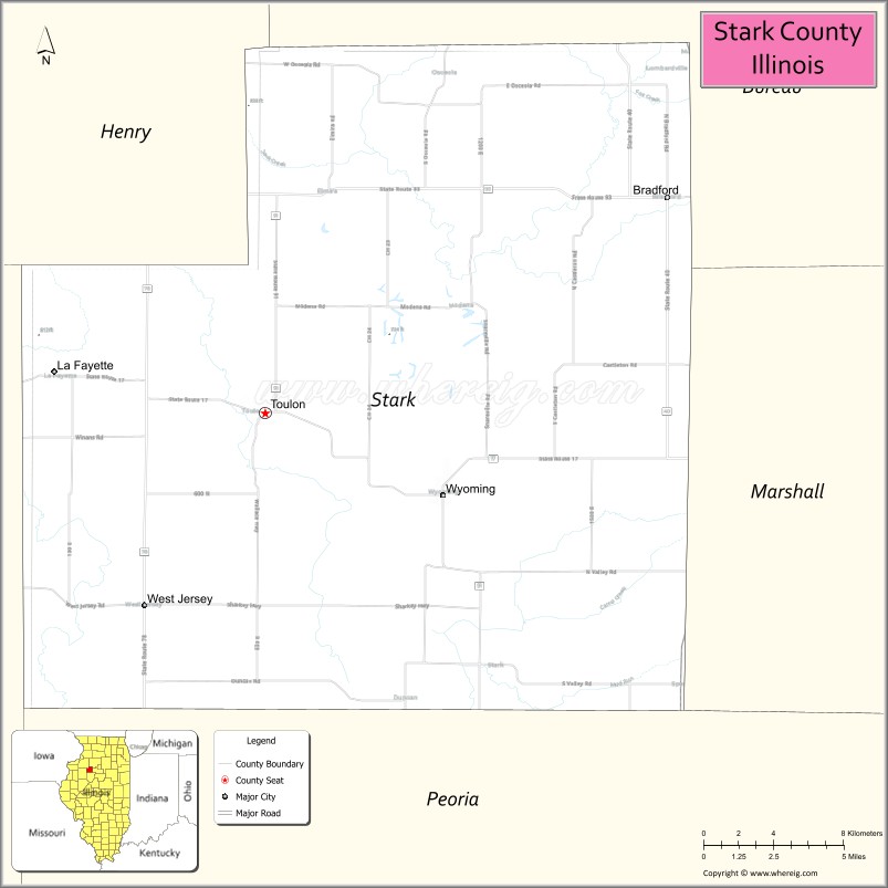
About Stark County Map, Illinois: The map showing the county boundary, county seat, major cities, highways, water bodies and neighbouring counties.
Most Viewed Illinois Links
Stark County, Illinois
Stark County is a county located in the U.S. state of Illinois. It's county seat is Toulon. As per 2020 census, the population of Stark County is 5294 people and population density is square miles. According to the United States Census Bureau, the county has a total area of 288 sq mi (746 km2). Stark County was established on 1839.
Facts about Stark County, Illinois
| Country | United States |
| State | Illinois |
| Region | North Central Illinois |
| County Seat | Toulon |
| Named After | John Stark |
| Established | 1839 |
| Organized | 1839 |
| Coordinates | 41.09° N, 89.80° W |
| Total Area | ~288 sq mi |
| Land Area | ~288 sq mi |
| Water Area | <1 sq mi |
| Population (2020) | ~5,796 |
| Population Rank | One of the smallest counties in Illinois |
| Largest City | Toulon |
| Main Industries | Agriculture, Manufacturing |
| Major Highways | Illinois Route 17, Illinois Route 78 |
| Time Zone | Central Time (UTC−06:00) |
| Known For | Rural farmland, small-town communities, agricultural heritage |
| Website | https://www.starkcoillinois.com |
Ctities in Stark county
| City Name | Type | Population (2020) | Pop. Density | Area |
|---|---|---|---|---|
| Bradford | Village | 676 | 1,698.5/sq mi (655.8/km2) | 0.398 sq mi (1.03 km2) |
| La Fayette | Village | 160 | 846.6/sq mi (326.9/km2) | 0.189 sq mi (0.49 km2) |
| Toulon | City | 1,193 | 1,173.1/sq mi (452.9/km2) | 1.017 sq mi (2.63 km2) |
| Wyoming | City | 1,300 | 1,522.2/sq mi (587.7/km2) | 0.854 sq mi (2.21 km2) |
Roads and Highways in Stark County, Illinois
Stark County is connected by several highways that provide access to central Illinois and surrounding rural communities.
- Illinois Route 17 – runs east-west through the county, connecting Toulon to Lacon and Kewanee
- Illinois Route 40 – runs north-south, linking Toulon to Galesburg and Peoria
- Illinois Route 91 – runs north-south, connecting the county to Kewanee and Peoria
- Illinois Route 78 – runs north-south nearby, linking the county to Canton and Jacksonville
Neighboring Counties of Stark County
- Knox County (north)
- Peoria County (east)
- Marshall County (southeast)
- Henry County (northwest)
- Fulton County (south)
Top Attractions in Stark County, Illinois
Stark County offers small-town charm, scenic landscapes, and outdoor recreation in a rural setting.
- Lake Toulon – A local destination for fishing, boating, and relaxation.
- Stark County Courthouse – A historic landmark located in Toulon.
- Toulon Downtown Area – Features shops, dining, and historic architecture.
- Stark County Fairgrounds – Hosts fairs and community events.
- Johnson Sauk Trail State Recreation Area (nearby) – Offers hiking, camping, and scenic views.
- Rural Scenic Drives – Provide views of farmland and countryside landscapes.
- Local Parks and Recreation Areas – Offer outdoor activities and community spaces.
Distance from Stark County to Nearby Cities
- Toulon to Peoria – 45 mi (72 km)
- Toulon to Galesburg – 35 mi (56 km)
- Toulon to Kewanee – 25 mi (40 km)
- Toulon to Rock Island – 80 mi (129 km)
- Toulon to Springfield – 110 mi (177 km)
FAQs about Stark County
Stark County is located in central Illinois, centered around the city of Toulon.
The county is known for its rural landscapes, small-town charm, and outdoor recreation.
Toulon is the county seat and the largest community in Stark County.
Yes, visitors can enjoy parks, lakes, and outdoor recreation throughout the county.
Stark County is accessible via Illinois Routes 17, 40, and 91, along with nearby highways.
- Adams County Map
- Alexander County Map
- Bond County Map
- Boone County Map
- Brown County Map
- Bureau County Map
- Calhoun County Map
- Carroll County Map
- Cass County Map
- Champaign County Map
- Christian County Map
- Clark County Map
- Clay County Map
- Clinton County Map
- Coles County Map
- Cook County Map
- Crawford County Map
- Cumberland County Map
- DeKalb County Map
- DeWitt County Map
- Douglas County Map
- DuPage County Map
- Edgar County Map
- Edwards County Map
- Effingham County Map
- Fayette County Map
- Ford County Map
- Franklin County Map
- Fulton County Map
- Gallatin County Map
- Greene County Map
- Grundy County Map
- Hamilton County Map
- Hancock County Map
- Hardin County Map
- Henderson County Map
- Henry County Map
- Iroquois County Map
- Jackson County Map
- Jasper County Map
- Jefferson County Map
- Jersey County Map
- Jo Daviess County Map
- Johnson County Map
- Kane County Map
- Kankakee County Map
- Kendall County Map
- Knox County Map
- Lake County Map
- LaSalle County Map
- Lawrence County Map
- Lee County Map
- Livingston County Map
- Logan County Map
- McDonough County Map
- McHenry County Map
- McLean County Map
- Macon County Map
- Macoupin County Map
- Madison County Map
- Marion County Map
- Marshall County Map
- Mason County Map
- Massac County Map
- Menard County Map
- Mercer County Map
- Monroe County Map
- Montgomery County Map
- Morgan County Map
- Moultrie County Map
- Ogle County Map
- Peoria County Map
- Perry County Map
- Piatt County Map
- Pike County Map
- Pope County Map
- Pulaski County Map
- Putnam County Map
- Randolph County Map
- Richland County Map
- Rock Island County Map
- St Clair County Map
- Saline County Map
- Sangamon County Map
- Schuyler County Map
- Scott County Map
- Shelby County Map
- Stark County Map
- Stephenson County Map
- Tazewell County Map
- Union County Map
- Vermilion County Map
- Wabash County Map
- Warren County Map
- Washington County Map
- Wayne County Map
- White County Map
- Whiteside County Map
- Will County Map
- Williamson County Map
- Winnebago County Map
- Woodford County Map
- Alabama Counties
- Alaska boroughs
- Arizona Counties
- Arkansas Counties
- California County Map
- Colorado Counties
- Connecticut Counties
- Delaware Counties
- Florida County Map
- Georgia County Map
- Hawaii Counties
- Idaho Counties
- Illinois Counties
- Indiana Counties
- Iowa Counties
- Kansas Counties
- Kentucky Counties
- Louisiana Counties
- Maine Counties
- Maryland Counties
- Massachusetts Counties
- Michigan County Map
- Minnesota Counties
- Mississippi Counties
- Missouri Counties
- Montana Counties
- Nebraska Counties
- Nevada Counties
- New York Counties
- New Hampshire Counties
- New Jersey Counties
- New Mexico Counties
- North Carolina Counties
- North Dakota Counties
- Ohio County Map
- Oklahoma Counties
- Oregon Counties
- Pennsylvania Counties
- Rhode Island Counties
- South Carolina Counties
- South Dakota Counties
- Map of Tennessee
- Texas County Map
- Utah Counties
- Vermont Counties
- Virginia Counties
- Washington Counties
- West Virginia Counties
- Wisconsin Counties
- Wyoming Counties