Map of Grundy County - Grundy County is a county located in the U.S. state of Illinois. Grundy County Map showing cities, highways, important places and water bodies. Get Where is Grundy County located in the map, major cities in Grundy county, population, areas, and places of interest.
Grundy County Map, Illinois
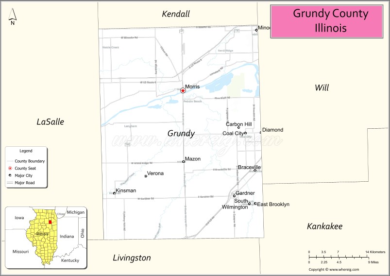
About Grundy County Map, Illinois: The map showing the county boundary, county seat, major cities, highways, water bodies and neighbouring counties.
Most Viewed Illinois Links
Grundy County, Illinois
Grundy County is a county located in the U.S. state of Illinois. It's county seat is Morris. As per 2020 census, the population of Grundy County is 52989 people and population density is square miles. According to the United States Census Bureau, the county has a total area of 418 sq mi (1,083 km2). Grundy County was established on 1841.
Facts about Grundy County, Illinois
| Country | United States |
| State | Illinois |
| Region | Northeastern Illinois |
| County Seat | Morris |
| Named After | Felix Grundy |
| Established | 1841 |
| Organized | 1841 |
| Coordinates | 41.29° N, 88.42° W |
| Total Area | ~430 sq mi |
| Land Area | ~418 sq mi |
| Water Area | ~12 sq mi |
| Population (2020) | ~51,421 |
| Population Rank | Mid-sized county in Illinois |
| Largest City | Morris |
| Main Industries | Manufacturing, Energy, Logistics, Agriculture |
| Major Rivers | Illinois River, Kankakee River |
| Time Zone | Central Time (UTC−06:00) |
| Known For | Illinois River corridor, industrial growth, proximity to Chicago suburbs |
| Website | https://www.grundyco.org |
Ctities in Grundy county
| City Name | Type | Population (2020) | Pop. Density | Area |
|---|---|---|---|---|
| Braceville | Village | 724 | 232.7/sq mi (89.9/km2) | 3.111 sq mi (8.06 km2) |
| Carbon Hill | Village | 372 | 2,089.9/sq mi (806.9/km2) | 0.178 sq mi (0.46 km2) |
| Coal City | Village | 5,705 | 1,015.7/sq mi (392.2/km2) | 5.617 sq mi (14.55 km2) |
| East Brooklyn | Village | 80 | 1,538.5/sq mi (594.0/km2) | 0.052 sq mi (0.13 km2) |
| Gardner | Village | 1,366 | 469.1/sq mi (181.1/km2) | 2.912 sq mi (7.54 km2) |
| Kinsman | Village | 90 | 1,323.5/sq mi (511.0/km2) | 0.068 sq mi (0.18 km2) |
| Mazon | Village | 979 | 1,626.2/sq mi (627.9/km2) | 0.602 sq mi (1.56 km2) |
| Morris | City | 14,163 | 1,429.3/sq mi (551.9/km2) | 9.909 sq mi (25.66 km2) |
| South Wilmington | Village | 710 | 1,443.1/sq mi (557.2/km2) | 0.492 sq mi (1.27 km2) |
| Verona | Village | 208 | 1,260.6/sq mi (486.7/km2) | 0.165 sq mi (0.43 km2) |
| Diamond | Village | 2,640 | 1,389.5/sq mi (536.5/km2) | 1.9 sq mi (4.92 km2) |
| Minooka | Village | 12,758 | 1,356.5/sq mi (523.8/km2) | 9.405 sq mi (24.36 km2) |
| Dwight | Village | 4,032 | 1,222.9/sq mi (472.2/km2) | 3.297 sq mi (8.54 km2) |
| Channahon | Village | 13,383 | 856.7/sq mi (330.8/km2) | 15.622 sq mi (40.46 km2) |
| Godley | Village | 566 | 522.6/sq mi (201.8/km2) | 1.083 sq mi (2.8 km2) |
Roads and Highways in Grundy County, Illinois
Grundy County is well-connected by major highways that link it to Chicago and other parts of northeastern Illinois.
- Interstate 80 – runs east-west through the county, connecting Morris to Joliet and Ottawa
- Interstate 55 – runs north-south nearby, providing access to Chicago and Bloomington
- Illinois Route 47 – runs north-south through the county, connecting Morris to Yorkville and Dwight
- Illinois Route 71 – runs east-west, linking Morris to Ottawa and Yorkville
- Illinois Route 113 – follows the Illinois River, connecting Morris to Wilmington and Kankakee
Neighboring Counties of Grundy County
- Kendall County (north)
- Will County (east)
- Kankakee County (southeast)
- Livingston County (south)
- LaSalle County (west)
Top Attractions in Grundy County, Illinois
Grundy County offers a mix of riverfront scenery, parks, and small-town charm centered around the city of Morris.
- Gebhard Woods State Park – A scenic park along the Illinois & Michigan Canal with trails and picnic areas.
- Illinois & Michigan Canal Trail – A popular path for biking, walking, and exploring history.
- Goold Park – A community park in Morris with playgrounds and open green space.
- Grundy County Courthouse – A historic landmark located in downtown Morris.
- Heidecke Lake – A popular destination for fishing, boating, and birdwatching.
- Nettle Creek Country Club – Offers golf and scenic surroundings.
- Downtown Morris – Features local shops, dining, and riverfront views.
Distance from Grundy County to Nearby Cities
- Morris to Joliet – 20 mi (32 km)
- Morris to Chicago – 60 mi (97 km)
- Morris to Ottawa – 25 mi (40 km)
- Morris to Kankakee – 40 mi (64 km)
- Morris to Bloomington – 90 mi (145 km)
FAQs about Grundy County
Grundy County is located in northeastern Illinois, southwest of Chicago.
The county is known for its riverfront scenery, parks, and access to the Illinois & Michigan Canal.
Morris is the county seat and the largest city in Grundy County.
Yes, visitors can enjoy parks, trails, lakes, and riverfront areas for outdoor recreation.
Grundy County is accessible via Interstate 80, Illinois Routes 47, 71, and 113, and nearby Interstate 55.
- Adams County Map
- Alexander County Map
- Bond County Map
- Boone County Map
- Brown County Map
- Bureau County Map
- Calhoun County Map
- Carroll County Map
- Cass County Map
- Champaign County Map
- Christian County Map
- Clark County Map
- Clay County Map
- Clinton County Map
- Coles County Map
- Cook County Map
- Crawford County Map
- Cumberland County Map
- DeKalb County Map
- DeWitt County Map
- Douglas County Map
- DuPage County Map
- Edgar County Map
- Edwards County Map
- Effingham County Map
- Fayette County Map
- Ford County Map
- Franklin County Map
- Fulton County Map
- Gallatin County Map
- Greene County Map
- Grundy County Map
- Hamilton County Map
- Hancock County Map
- Hardin County Map
- Henderson County Map
- Henry County Map
- Iroquois County Map
- Jackson County Map
- Jasper County Map
- Jefferson County Map
- Jersey County Map
- Jo Daviess County Map
- Johnson County Map
- Kane County Map
- Kankakee County Map
- Kendall County Map
- Knox County Map
- Lake County Map
- LaSalle County Map
- Lawrence County Map
- Lee County Map
- Livingston County Map
- Logan County Map
- McDonough County Map
- McHenry County Map
- McLean County Map
- Macon County Map
- Macoupin County Map
- Madison County Map
- Marion County Map
- Marshall County Map
- Mason County Map
- Massac County Map
- Menard County Map
- Mercer County Map
- Monroe County Map
- Montgomery County Map
- Morgan County Map
- Moultrie County Map
- Ogle County Map
- Peoria County Map
- Perry County Map
- Piatt County Map
- Pike County Map
- Pope County Map
- Pulaski County Map
- Putnam County Map
- Randolph County Map
- Richland County Map
- Rock Island County Map
- St Clair County Map
- Saline County Map
- Sangamon County Map
- Schuyler County Map
- Scott County Map
- Shelby County Map
- Stark County Map
- Stephenson County Map
- Tazewell County Map
- Union County Map
- Vermilion County Map
- Wabash County Map
- Warren County Map
- Washington County Map
- Wayne County Map
- White County Map
- Whiteside County Map
- Will County Map
- Williamson County Map
- Winnebago County Map
- Woodford County Map
- Alabama Counties
- Alaska boroughs
- Arizona Counties
- Arkansas Counties
- California County Map
- Colorado Counties
- Connecticut Counties
- Delaware Counties
- Florida County Map
- Georgia County Map
- Hawaii Counties
- Idaho Counties
- Illinois Counties
- Indiana Counties
- Iowa Counties
- Kansas Counties
- Kentucky Counties
- Louisiana Counties
- Maine Counties
- Maryland Counties
- Massachusetts Counties
- Michigan County Map
- Minnesota Counties
- Mississippi Counties
- Missouri Counties
- Montana Counties
- Nebraska Counties
- Nevada Counties
- New York Counties
- New Hampshire Counties
- New Jersey Counties
- New Mexico Counties
- North Carolina Counties
- North Dakota Counties
- Ohio County Map
- Oklahoma Counties
- Oregon Counties
- Pennsylvania Counties
- Rhode Island Counties
- South Carolina Counties
- South Dakota Counties
- Map of Tennessee
- Texas County Map
- Utah Counties
- Vermont Counties
- Virginia Counties
- Washington Counties
- West Virginia Counties
- Wisconsin Counties
- Wyoming Counties